
News
Il Consiglio nazionale delle ricerche e la gestione delle emergenze. Il caso dell’Emilia-Romagna

Domani 27 settembre 2023 alle 17, nell’ambito dell’evento “Il Consiglio nazionale delle ricerche e la gestione delle emergenze. Il caso dell’Emilia-Romagna”, i rappresentanti degli istituti Irpi e Igag riceveranno dal Capo Dipartimento Protezione Civile Fabrizio Curcio una targa di ringraziamento per l’impegno profuso in occasione dell’alluvione che ha colpito la regione Emilia-Romagna lo scorso maggio. Per IRPI, Federica Fiorucci presenterà “L’esperienza di Cnr-Irpi per le attività di supporto all’emergenza Emilia-Romagna 2023”.
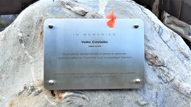
Una targa in memoria di Velio Coviello
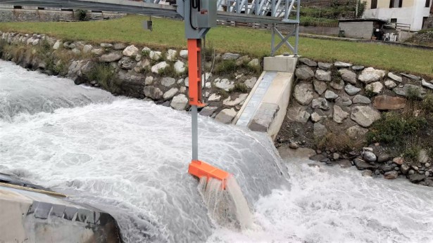
Venerdì 21 luglio, presso la stazione di misura delle portate e del trasporto solido di Ponte Stelvio sul Rio Solda (Alto Adige), è stata scoperta una targa in memoria di Velio Coviello, ricercatore del CNR IRPI tragicamente scomparso nell’aprile di quest’anno.
La stazione di Ponte Stelvio è stata realizzata ed è gestita dall’Agenzia per la Protezione civile della Provincia Autonoma di Bolzano Alto Adige – Autonome Provinz Bozen Südtirol. Con il suo lavoro e la sua competenza, Velio ha dato un contributo determinante al lavoro del consorzio impegnato nella gestione di questo sito di monitoraggio.
L’evento si è svolto a valle di una riunione del Comitato Glaciologico Italiano, nel corso della quale è stata deliberata la cooptazione postuma di Velio Coviello nel comitato stesso.
targa in memoria di Velio Coviello
stazione di misura
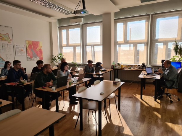
Conclusa la seconda edizione del workshop Cnr-Irpi
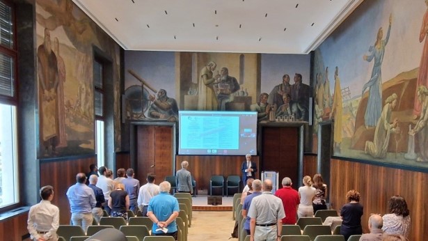
Si sono conclusi ieri i lavori della seconda edizione del workshop dell’Istituto di ricerca per la protezione idrogeologica (Irpi) del Cnr, dal titolo “La mitigazione dei rischi geo-idrologici in un contesto di cambiamento globale: quali risposte dalla comunità scientifica”, organizzato presso la Sala Marconi della sede centrale del Cnr in piazzale Aldo Moro a Roma. I lavori sono stati aperti dal direttore dell’Istituto, Tommaso Moramarco e dal direttore del Dipartimento scienze del sistema terra e tecnologie per l’ambiente del Cnr, Fabio Trincardi, che hanno evidenziato il ruolo chiave dell’IRPI sui dissesti geo-idrologici, a livello nazionale ed internazionale. A seguire è stato osservato un minuto di silenzio in ricordo della ricercatrice del Cnr-Stems, Maria Vittoria Prati, e del suo tirocinante, Fulvio Filace, vittime del tragico incidente durante lo svolgimento del loro lavoro. La presidente Maria Chiara Carrozza si è unita nel pomeriggio ai lavori ricordando nel suo intervento di saluto l’importanza della ricerca scientifica che viene quotidianamente svolta dal Cnr nell’affrontare le sfide estremante attuali dovute al cambiamento globale e alle sue complesse conseguenze. Ha inoltre ribadito la necessità di diffondere la cultura del rischio attraverso la sinergia tra i ricercatori e gli stakeholder attivi sul territorio. Argomenti questi approfonditi ed analizzati nel dettaglio durante l’occasione di confronto offerta dalla tavola rotonda che ha visto la partecipazione del Dott. Carlo Cacciamani di Italia Meteo, della Dott.ssa Martina Bussettini di Ispra e del Dott. Giulio Fancello del Dipartimento della Protezione Civile nazionale.
Il minuto di silenzio in ricordo della ricercatrice del Dnr-Stems Maria Vittoria Prati e del suo tirocinante Fulvio Filace
Il workshop è stato una occasione di incontro tra i ricercatori Irpi e di altri Istituti Cnr/EPR/Università, su tematiche estremamente attuali e concernenti il rischio geo-idrologico in termini di prevenzione, previsione e mitigazione in un contesto di cambiamento globale. Gli interventi che si sono susseguiti, anche da remoto, durante le 7 sessioni tematiche hanno messo in luce le recenti innovazioni tecnologiche nel campo del monitoraggio nonché delle tecniche per la determinazione del loro impatto al suolo fino alle geo-scienze planetarie. Trasversalmente a queste tematiche si è discusso dell’importanza e necessità di intraprendere strategie comunicative e informative per una maggiore diffusione della cultura della percezione del rischio. Una sessione del workshop è stata interamente dedicata al ricordo del collega Velio Coviello, ricercatore Irpi presso la sede di Padova, prematuramente scomparso ad Aprile di quest’anno in un incidente di montagna. Gli interventi hanno ricordato le tematiche di ricerca che negli anni Velio aveva promosso e attivamente condotto collaborando con vari enti di ricerca e colleghi delle sedi dell’istituto, ma soprattutto hanno voluto ripercorrere la storia di un amico, collega e giovane e promettente ricercatore.
II° Workshop IRPI – PROGRAMMA
La IIa Edizione del Workshop IRPI (3-5 luglio 2023) si propone di stabilire una occasione di incontro su tematiche di immediata rilevanza concernenti il rischio geo-idrologico in termini di prevenzione, previsione e mitigazione in un contesto di cambiamento globale. A tal fine, il Workshop intende far luce sui recenti progressi dell’attività scientifica del CNR IRPI nel campo dei fenomeni geo-idrologici, proiettati anche nel Piano di Rilancio del CNR. Sono state individuate sette Sessioni.
Il WORKSHOP ha promosso la partecipazione anche di Ricercatori di altri Istituti CNR/EPR/Università, che costituiscono la rete di collaborazioni scientifiche dell’IRPI.
Template per le presentazioni orali dei relatori del Workshop »
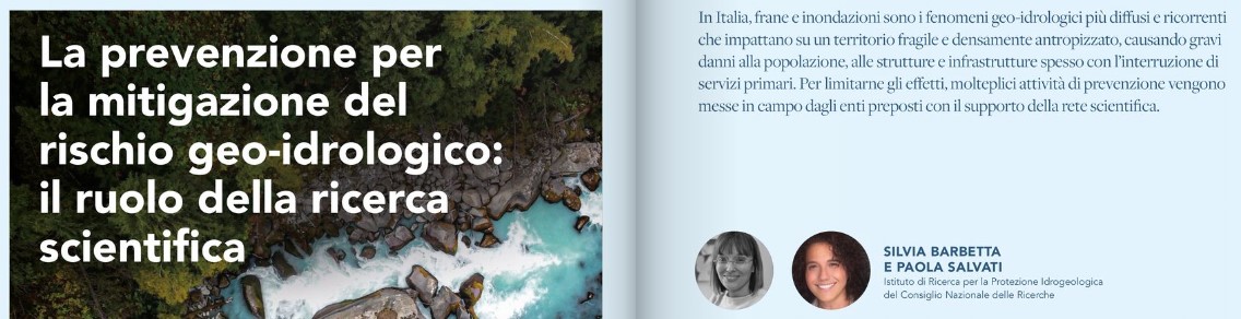
La prevenzione per la mitigazione del rischio geo-idrologico
Contributo IRPI a cura di Silvia Barbetta e Paola Salvati pubblicato sulla rivista dell’Ente Italiano di Normazione “STANDARD – Il magazine di UNI per un mondo fatto bene” numero 3/2023.
Il focus principale di quest’ultima edizione è il tema della tutela e cura del territorio. Il contributo di IRPI tratta del ruolo della ricerca per la mitigazione del rischio geo-idrologico.
l’articolo è disponibile a pagina 28 del link https://bit.ly/3oV0sFb
Special Issue of Frontiers in remote sensing journal on “small, Uncrewed Aircraft Systems (sUAS)”
The Special Issue of Frontiers in remote sensing journal on “small, Uncrewed Aircraft Systems (sUAV)” (abstract submission deadline: 06 November 2023, manuscript submission deadline 04 December 2023) is opened.
The Guest Editors are: Dr John Fulton (United States Geological Survey (USGS), US); Dr. Silvia Barbetta (National Research Council, Research Institute for Geo-hydrological Protection, Italy), Dr. Tommaso Moramarco (National Research Council, Research Institute for Geo-hydrological Protection, Italy); Dr. Carl J. Legleiter (United States Geological Survey (USGS), US and Dr. Cian Dawson (United States Geological Survey (USGS), US).
d
For information: jwfulton@usgs.gov; silvia.barbetta@irpi.cnr.it; tommaso.moramarco@irpi.cnr.it; cjl@usgs.gov ; cbdawson@usgs.gov
The goal of this Research Topic is to establish a repository of sUAS research and operations that advance the utility of sUAS and various sensors used to address challenging earth science topics.
Link: https://www.frontiersin.org/research-topics/52585/small-uncrewed-aircraft-systems-suas#main-content
Italian Tripartite Assembly on the European Open Science Cloud
L’evento “Italian Tripartite Assembly on the European Open Science Cloud” (ITAEOSC2023), si terrà a Roma il 5 giugno, promosso dal MUR nell’ambito degli eventi nazionali tripartiti dell’EOSC-Association, European Commission e EOSC Steering Board.
L’evento avrà luogo presso la Sala Convegni della sede centrale del Consiglio Nazionale delle Ricerche. A dare il via all’assemblea, saranno la Presidente del CNR Maria Chiara Carrozza e il Ministro del MUR Anna Maria Bernini.
Il programma metterà a fuoco le iniziative, opportunità e necessità di collaborazione nazionale, europea e internazionale per perseguire in modo coordinato la transizione verso il paradigma Open Science e la costruzione dello European Open Science Cloud: una piattaforma trasversale per la ricerca europea che realizzerà un internet dei dati e dei servizi scientifici, al fine di sostenere una collaborazione scientifica aperta e trasparente.
La sessione mattutina si aprirà con i messaggi dei rappresentanti della governance: MUR, Commissione Europea, Associazione EOSC, Consiglio Direttivo EOSC. La sessione proseguirà con una tavola rotonda di EOSC “Doers” sulle azioni in corso e prospettiche per la realizzazione del Piano Nazionale per la Scienza Aperta (PNSA).
La sessione pomeridiana coinvolgerà la comunità di ricerca nazionale per discutere l’implementazione del PNSA e le sinergie con EOSC. I rappresentanti delle iniziative in corso che contribuiscono agli obiettivi di questo piano saranno invitati a condividere le loro esperienze e ad identificare gli elementi per un’azione coerente verso l’implementazione dell’Open Science in Italia.
L’agenda, la registrazione e ulteriori dettagli sono disponibili alla pagina: https://open-science.it/itaeosc2023 .
Special Issue of Remote Sensing journal on “State-of-the-Art on Satellite and UAV Remote Sensing in Geoscience Research”
The Special Issue of Remote Sensing journal on “State-of-the-Art on Satellite and UAV Remote Sensing in Geoscience Research” (deadline: 30 November 2023) is opened.
The Guest Editors are: Dr Gabriella Caroti (Department of Civil and Industrial Engineering, Università di Pisa, Pisa, Italy); Dr. Yuankun Xu (Department of Earth and Planetary Science, University of California, Berkeley, 201 McCone Hall, Berkeley, CA 94720, USA) and Dr Francesca Ardizzone (National Research Council of Italy, Research Institute of Geo-Hydrological Protection (CNR IRPI), Via della Madonna Alta 126, 06128 Perugia, Italy.
For information: gabriella.caroti@unipi.it; yuankunx@berkeley.edu; francesca.ardizzone@irpi.cnr.it
This Special Issue focuses on the studies that utilize state-of-the-art remote sensing techniques to advance our knowledge in geosciences across a broad range of spectrums.
Link: https://www.mdpi.com/journal/remotesensing/special_issues/RU0HJ8R69F
Venticinque anni fa il disastro di Sarno: un evento chiave per la riduzione del rischio geo-idrologico in Italia
Sono trascorsi 25 anni da quel 5 maggio 1998, quando Sarno ed altri quattro comuni della Campania furono interessati da una serie di colate di fango che determinarono la perdita di 160 vite umane, e danni materiali quantificati in circa 30 milioni di euro. Si trattò di un evento molto complesso, sia dal punto di vista dei fenomeni che della gestione dell’emergenza, risultando tra quelli più impattanti nella lunga serie dei disastri geo-idrologici in Italia. La reazione emotiva fu molto forte nell’opinione pubblica così come nella classe politica, al punto da disporre una fitta serie di attività di prevenzione non-strutturale a scala nazionale confluite nella legge 267/1998, che riprendeva in parte quanto già inserito nella Legge 183/1989. Oltre a favorire interventi finalizzati alla riduzione del rischio geo-idrologico, il disastro del 1998 portò ad una notevole implementazione dell’intero sistema della Protezione Civile italiana, sia in termini di prevenzione dei rischi naturali che di risposta all’emergenza. Sebbene i progressi fatti in questi 25 anni siano notevoli anche in termini di conoscenze scientifiche, il 93.9% dei comuni italiani permane in condizioni di rischio per frane, alluvioni e/o erosione costiera, con danni alle persone ogni anno (https://polaris.irpi.cnr.it/report/).
Per ulteriori approfondimenti sul disastro del 1998 si rimanda all’articolo di Esposito et al. (2023) pubblicato sulla rivista scientifica “International Journal of Disaster Risk Reduction”, che fornisce una dettagliata descrizione dell’evento ed i progressi raggiunti dopo di esso, mettendo in evidenza le questioni ancora aperte per migliorare le attività di prevenzione. Si consiglia, inoltre, la consultazione dei seguenti focus pubblicati sul sito Polaris-IRPI:
Special Issue “Wind and Precipitation – Climatic Influence on the Mediterranean Basin”
Il bacino del Mediterraneo è un ambiente caratterizzato da una complessa dinamica meteoclimatica e rappresenta un sistema particolarmente sensibile e stimolante da studiare, sia per quel che riguarda la modellistica previsionale, sia per la ricostruzione di eventi e l’analisi di scenari d’impatto sul territorio e sulle articolate attività antropiche ivi presenti.
Questo Special Issue vuole essere l’occasione per fare il punto sia sullo stato dell’arte della modellistica, meteorologica e non solo, finalizzata alla previsione di eventi precipitativi e vento in ambito mediterraneo alle diverse scale temporali (dal nowcasting alla climatologia), sia per presentare casi studio e proiezioni anche per evidenziare variabilità stagionale o a lungo termine.
Obbiettivo principale dell’edizione è dunque quello di migliorare la conoscenza degli eventi fenomenologici nell’ambito del clima che caratterizza il bacino del Mediterraneo, anche alla luce dei cambiamenti climatici.
Gli articoli inviati possono riguardare, ma non sono limitati a questi, i seguenti argomenti scientifici:
- numerical weather prediction modeling
- precipitation forecast
- nowcasting
- wind forecast
- severe weather
- impact of extreme weather events
- trend analysis
La ricerca incontra i giovani
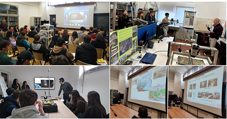 Oggi, 13 aprile, nell’ambito delle celebrazioni per il Centenario della fondazione del Consiglio Nazionale delle Ricerche, i sei Istituti del CNR (IBBR, IOM, IRET, IRPI, ISAFOM, SCITEC) che hanno sede in Umbria hanno organizzato alcune attività dedicate agli allievi delle scuole superiori all’insegna dell’inclusività e della partecipazione.
Gli obiettivi principali dell’iniziativa “La ricerca incontra i giovani” sono stati quelli di far conoscere ai ragazzi la rete scientifica operante nel loro territorio e di stimolare la curiosità sui progressi scientifici, tecnologici e applicativi raggiunti dai diversi Istituti.
A Perugia, i ricercatori di IRPI e degli altri Istituti che operano in città hanno dato vita all’iniziativa “Laboratori aperti”, accogliendo nelle rispettive sedi gli studenti dell’Istituto tecnico tecnologico statale ‘Alessandro Volta’ e dell’Istituto di istruzione superiore ‘Giordano Bruno’.
Nel nostro Istituto, i ricercatori del gruppo di geomorfologia hanno interagito con i giovani ospiti offrendo loro l’opportunità di visualizzare alcune immagini aeree con gli strumenti del laboratorio di fotointerpretazione che consentono la visione tridimensionale del territorio, e di riconoscere alcune forme tipiche dei movimenti franosi. Durante la visita al laboratorio di idrologia i ricercatori hanno invece illustrato ai ragazzi le strumentazioni installate sul territorio, e visionato le immagini e i segnali trasmessi dai satelliti costruiti e lanciati dalle principali agenzie spaziali Europee e Americane per il monitoraggio delle principali componenti del ciclo dell’acqua: la pioggia, la neve, l’evaporazione e il deflusso dei fiumi.
Dopo essersi alternati nelle visite ai diversi laboratori, l’attività si è conclusa presso l’Aula Florisa Melone di IRPI, dove il direttore Tommaso Moramarco ha brevemente descritto la storia del CNR e i ricercatori hanno riassunto alcune attività dei rispettivi Istituti e risposto alle domande dei partecipanti.
Alcuni colleghi dell’IRPI ricordano Velio così
Per i tanti che non l’hanno conosciuto, o lo hanno fatto solo marginalmente, vorremmo tratteggiare un breve ricordo di Velio, che all’IRPI di Torino ha mosso i suoi primi passi nella ricerca.
Velio è arrivato all’IRPI nel 2006 per la sua tesi triennale (“Fenomeni di instabilità in ambiente d’alta montagna. Studio e modellazione della valanga di ghiaccio del 25 agosto 2005 sulla parete nord-orientale del Monte Rosa”). L’introduzione inizia così “Alla base del lavoro svolto in questa tesi, ci sono, da un lato la mia grande passione per la montagna, dall’altro il mio assoluto bisogno di sentirmi in qualche modo utile alla “causa ambientale”. In queste parole è racchiuso il senso di tutta la sua attività futura…
Ha proseguito poi, sempre con noi, con una tesi magistrale dal titolo “Monitoraggio di emissioni acustiche in roccia nell’ambito di indagini relative agli effetti dei cambiamenti climatici sulla degradazione del permafrost alpino Applicazione al sito della Capanna Carrel (3835 m), M. Cervino “: è stato in questa occasione che Velio ha iniziato ad occuparsi di sismica e a lavorare con i sensori di vibrazione (cominciando con i geofoni e i sismografi per arrivare ai sensori infrasonici, tutti strumenti che ha continuato ad utilizzare con intelligenza e fantasia in tanti ambiti diversi). Il destino ha voluto che la sua vita si sia chiusa proprio nei luoghi intorno a Cervinia dove era iniziata la sua avventura scientifica.
A partire dal 2010 Velio ha iniziato a lavorare all’IRPI come assegnista di ricerca, occupandosi del rilevamento sismico delle colate detritiche e conseguendo il suo dottorato al Politecnico di Torino nel 2015. Nel 2016 la decisione di cogliere la sfida di un post-doc in Messico per lavorare sui lahar. Tornato in Italia nel 2017 ha lavorato come ricercatore a tempo determinato presso l’Università di Bolzano e, finalmente, nel 2020 è entrato di ruolo all’IRPI, scegliendo la sede di Padova per essere più vicino ai siti di monitoraggio sui quali ormai lavorava da anni, in primis quello del torrente Gadria a Lasa (BZ). Negli anni più recenti ha continuato le sue ricerche sull’uso di sensori sismici per il monitoraggio delle colate detritiche, estendendole alla più ampia tematica della sismicità ambientale applicata allo studio dei processi di trasporto solido e di piena. Grazie alla presenza in Alto Adige di stazioni idrometriche e di monitoraggio del sedimento tecnologicamente avanzate ha anche avviato, in collaborazione con la Provincia autonoma di Bolzano – Alto Adige e la Libera Università di Bolzano, studi sul trasporto solido in sospensione e al fondo, con l’obiettivo di pervenire a bilanci del sedimento a scala di bacino.
Persona concreta e fattiva, non si tirava indietro di fronte a nessuna sfida, mettendo tutto se stesso in quello che faceva. Intelligente, propositivo, critico, fortemente indipendente, aperto al confronto e pronto anche allo scontro, se riteneva di dover difendere le proprie idee e la propria autonomia.
Al CNR e all’IRPI vengono a mancare un ricercatore brillante, competente e appassionato; un collega che non si accontentava di portare avanti le proprie ricerche, ma che, come ricordato dal Direttore, voleva contribuire attivamente alla vita dell’istituto e dell’Ente. Sapeva fare rete e sapeva essere, oltre che collega, amico.
Ci mancherà; ci manca già, tantissimo.
Marta, Massimo, Lorenz
Velio Coviello, Cnr-Irpi researcher, victim of the avalanche in Valle d’Aosta
Velio Coviello, researcher at the Hydrogeological Protection Research Institute in Padua since the end of 2020, passed away suddenly in the avalanche that broke out on the afternoon of April 1 in Valle d’Aosta.
He graduated cum laude in 2009 in Environmental Engineering at the Polytechnic University of Turin and received his PhD in 2015, at the same university, with a thesis entitled “Debris flow seismic monitoring and warning” and spending a period abroad at the landslide research centre at the USGS Golden (Colorado, USA); he then developed post-doctoral research in Mexico (UNAM Geoscience Center) studying debris flows in volcanic environments (lahar) and was, between 2017 and 2020, a fixed-term researcher at the Free University of Bozen/Bolzano.
His research interests concerned the characterisation of mass movements and solid transport through ground surveys and monitoring data. In particular, Velio conducted research on the use of environmental seismology for the automatic identification of landslide and torrential processes and the development of warning systems.
Velio was a passionate researcher with great intellectual vivacity and honesty.
His dedication to understanding environmental processes by integrating modelling approaches with intense and continuous field work remains a valuable legacy for the scientific world in the field of geo-hydrological hazards in mountain environments.
See also:
- Interview with Velio Coviello on TG2 Dossier of 10/15/2022 (between 2.10 and 3.30). Excerpts of this video were widely taken in the regional Rai services:
https://www.rainews.it/rubriche/tg2dossier/video/2022/10/TG2-Dossier-del-15102022-6a2019e4-1795-4ccc-b379-80d24417ff9c.html - https://www.ansa.it/piemonte/notizie/2023/04/02/scialpinisti-morti-in-valtournenche-identificati-i-corpi_64d7ba92-fd7b-4d6b-963b-146b7aa7e68c.html
Two IRPI researchers won best poster award at National Congress of Planetary Science
From February 6-10, 2023, the 18th National Congress of Planetary Sciences was held in Perugia, Italy, at the historic Sala dei Notari. Maria Teresa Brunetti and Silvia Peruccacci, CNR researchers at the Research Institute for Hydrogeological Protection (IRPI) in Perugia, presented a work titled “Ubiquity of landslides in the Solar System,” which won them the award for best poster.
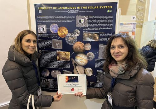
Da sinistra: Silvia Peruccacci e Teresa Brunetti
The research is the result of interdisciplinary work applying techniques from geomorphology and landslide recognition to the field of planetary science. Specifically, the poster shows the state of the art related to the observation and study of landslides on solid bodies in the Solar System. This review of the scientific literature is being published by Oxford University Press.
Aggiornato il catasto delle frane di alta quota nelle Alpi
Attualmente il catasto contiene informazioni relative a 772 processi di instabilità naturale (frane, colate detritiche, instabilità glaciale), avvenuti nelle Alpi italiane ad una quota superiore ai 1500 metri durante il periodo 2000-2022. Fra le tipologie di processi più frequenti si segnalano 279 crolli di roccia, pari al 36 % del totale e 191 colate detritico-torrentizie, pari al 25 % del totale dei processi censiti. Le regioni maggiormente colpite risultano essere la Valle d’Aosta (311 processi, pari al 40,3 % del totale), La Lombardia (147 processi, pari al 19,1 % del totale) e il Piemonte (126 processi, pari al 16,3 % del totale), seguito a breve distanza dal Trentino Alto Adige con 121 processi, pari al 15,7 % del totale. L’anno record per il periodo considerato è sicuramente il 2022, per il quale sono documentati 71 processi di instabilità e di questi, ben 60 (85 %) sono avvenuti in estate. L’analisi su base annuale ha fatto emergere anche una evidente tendenza all’aumento degli eventi con il passare degli anni, con ogni probabilità un effetto dell’aumento delle temperature alle quote più elevate ed alla conseguente degradazione del permafrost. La stagione in cui questi processi si manifestano con maggior frequenza è quella estiva (giugno, luglio ed agosto), con 434 eventi documentati, pari al 56 % del totale. L’attività di incremento della casistica presente è indirizzata verso l’inserimento degli eventi di frana ante-2000 e verso un aggiornamento periodico dipendente dal numero di eventi accaduti e censiti. Inoltre, particolare importanza verrà data alla ricerca di soluzioni informatiche in grado di migliorare la fruibilità del prodotto nel suo complesso. Mediante la realizzazione di questo semplice webgis si vuole fornire, da un lato, un concreto strumento alla comunità scientifica impegnata nello studio degli effetti del cambiamento climatico e agli enti di governo del territorio e, dall’altro, un elemento di stimolo verso la realizzazione di un Catasto delle frane di alta quota nelle Alpi europee.


Opportunità per una borsa di Dottorato di Ricerca in collaborazione con il CNR-IRPI
Nell’ambito del progetto “ Tech4You – Technologies for climate change adaptation and quality of life improvement” finanziato con fondi PNRR – Ecosistemi dell’Innovazione, il CNR-IRPI ha promosso l’attivazione di una borsa di dottorato di ricerca in collaborazione con la Scuola di Dottorato in Scienze e Ingegneria dell’Ambiente, delle Costruzioni e dell’Energia, dell’Università della Calabria. La tematica di ricerca riguarda lo sviluppo di sistemi di monitoraggio in-situ o da remoto per la misurazione delle proprietà geotecniche e l’erosione idrica dei suoli in bacini idrografici interessati da incendi boschivi. Il bando con le relative informazioni è consultabile al seguente link:
La domanda di ammissione potrà essere presentata online entro le ore 12:00 (mezzogiorno ora italiana) del giorno 30 gennaio 2023.
Masso ad Ischia, un recente lavoro aveva classificato quel tratto di strada come possibile bersaglio di crolli
Il 24 dicembre scorso ad Ischia, in via Nuovo Montevico, località Lacco Ameno, un grosso masso si è staccato da un costone roccioso colpendo la strada e danneggiando uno scooter e la segnaletica. Fortunatamente non ci sono stati danni a persone.
I ricercatori del CNR IRPI ed IREA hanno recentemente pubblicato un lavoro nella rivista “Geomatics, Natural Hazards and Risk” (Taylor & Francis online) in cui discutono la realizzazione di una mappa di suscettibilità per crolli in roccia in tutta l’isola, utilizzando un modello tridimensionale che simula la caduta dei blocchi, studiando il possibile impatto sulla rete stradale e sugli edifici.
I risultati del lavoro mostrano che il tratto di strada in cui si è verificato l’evento era classificato come possibile bersaglio di crolli. Sebbene molte delle strade dell’isola fossero state classificate in maniera simile, o molto spesso con probabilità maggiore di essere colpite, la corrispondeza trovata è importante per la validazione dei risultati del lavoro e fornisce una buona indicazione per continuare a studiare i fenomeni di crollo con questo metodo, e migliorarne ancora le capacità predittive con la raccolta di dati di alta precisione.
Sebbene la tragica frana che recentemente si è verificata ad Ischia abbia coinvolto massi rocciosi, precisiamo che il fenomeno di dissesto in quel caso era di tipo molto diverso, trattandosi di una colata di fango. I massi erano stati trasportati dalla colata, ed i risultati del lavoro indicato qui sono solo molto parzialmente confrontabili con quanto accaduto a Casamicciola.
Link al lavoro pubblicato: https://doi.org/10.1080/19475705.2022.2131472
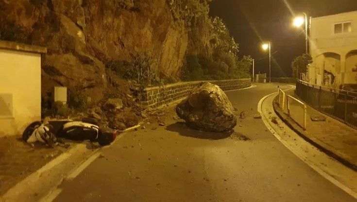
Fonte repubblica.it
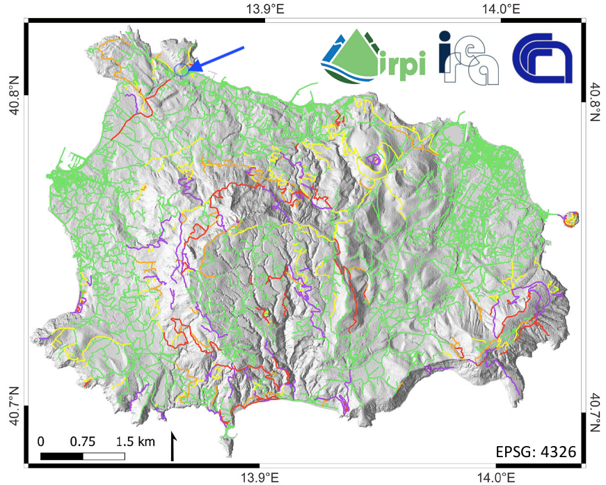
La figura si riferisce ai risultati pubblicati nel lavoro descritto; la zona in cui si è verificato l’evento è evidenziata con una freccia
La Montagna di Ghiaccio
Domenica 11 dicembre, in occasione della Giornata Internazionale della Montagna, la Cabina di Regia dei Ghiacciai Valdostani, cui l’IRPI partecipa, organizza in collaborazione con il Forte di Bard un evento divulgativo intitolato “La Montagna di Ghiaccio”, che si svolgerà in presenza presso il Forte di Bard (AO) ed in streaming. Il programma dettagliato e le informazioni per la partecipazione sono disponibili nella locandina allegata.
Topographic thresholds for gully head formation in badlands. A new study published on “Earth Surface Processes and Landforms”
The article, titled “Topographic thresholds for gully head formation in badlands” has been recently published in the journal “Earth Surface Processes and Landforms”: The study was co-authored by Mauro Rossi & Dino Torri from Cnr Irpi and Jean Poesen, Sofie De Geeter & Cati Cremer from the Department of Earth and Environmental Sciences, KU Leuven, Heverlee, Belgium.
In synthesis
The study extends the gully topographic threshold model to badlands on the basis of data collected in the Mediterranean environment in Italy and Spain, characterized by diversified climatic, lithological, geological and anthropogenic settings. Criteria for the attribution of Curve Number values has been more objectively defined in order to reduce arbitrariness in threshold applications. Physical basics behind the gully head threshold concept have been revised requiring a description of the soil resistance in terms of frictional and cohesive components.
In detail
Gully erosion is a particularly damaging process which is not yet sufficiently understood and parameterized. Gully head topographic threshold relative to Hortonian runoff have been studied in cropland, rangeland and forest. This study extends such modelling approach to badlands. Different badlands (eight sites) have been studied in the Mediterranean environment in Italy and Spain, characterized by diversified climatic, lithological, and geological settings under different anthropogenic conditioning. Many badlands have been characterized by their specific human history in addition to their geomorphological properties. Land use, as part of the human history, strongly affected the formation many badlands and their development, through extremely impacting land exploitation (usually overgrazing). The effect of geological and geomorphological processes is usually particularly well visible. While the weakening effect of joints is confirmed, the different geological layer bedding orientation with respect to the slope aspect generates a different development of badland morphologies and different values of gully head thresholds values (as shown in two badlands sites on the same geological material and climate.
The selection of Curve Number values, at the base of the introduction of land use into the gully head thresholds, has been more objectively defined in order to reduce arbitrariness in threshold application. The study additionally revises some of the physical basics behind the gully head threshold concept, requiring a description of the soil resistance in terms of frictional and cohesive components. This implies the explicit inclusion of rock fragment into the grain size distribution, which cannot be limited to fine grains. It results into an enriched threshold formulation that allows to describe the condition for gully head initiation and retreat as the result of the trade-off between the frictional and cohesive components of the soil resistance forces. Eventually, the gully head threshold concept is confirmed and extended to include badlands.
Citation:
Rossi, M., Torri, D., De Geeter, S., Cremer, C. and Poesen, J., Topographic thresholds for gully head formation in badlands. Earth Surface Processes and Landforms. https://doi.org/10.1002/esp.5473
Web link: https://onlinelibrary.wiley.com/doi/10.1002/esp.5473
Additional references:
Rossi, M., Torri, D., Santi, E., 2015. Bias in topographic thresholds for gully heads. Nat Hazards 79, 51–69. https://doi.org/10.1007/s11069-015-1701-2
Torri, D., Poesen, J., 2014. A review of topographic threshold conditions for gully head development in different environments. Earth-Science Reviews 130, 73–85. https://doi.org/10.1016/j.earscirev.2013.12.006
Torri, D., Poesen, J., Rossi, M., Amici, V., Spennacchi, D., Cremer, C., 2018a. Gully head modelling: A Mediterranean badland case study: Gully head topographic threshold for badlands. Earth Surface Processes and Landforms 43, 2547–2561. https://doi.org/10.1002/esp.4414
Torri, D., Rossi, M., Brogi, F., Marignani, M., Bacaro, G., Santi, E., Tordoni, E., Amici, V., Maccherini, S., 2018b. Chapter 4 – Badlands and the Dynamics of Human History, Land Use, and Vegetation Through Centuries, in: Nadal-Romero, E., Martínez-Murillo, J.F., Kuhn, N.J. (Eds.), Badlands Dynamics in a Context of Global Change. Elsevier, pp. 111–153. https://doi.org/10.1016/B978-0-12-813054-4.00004-6
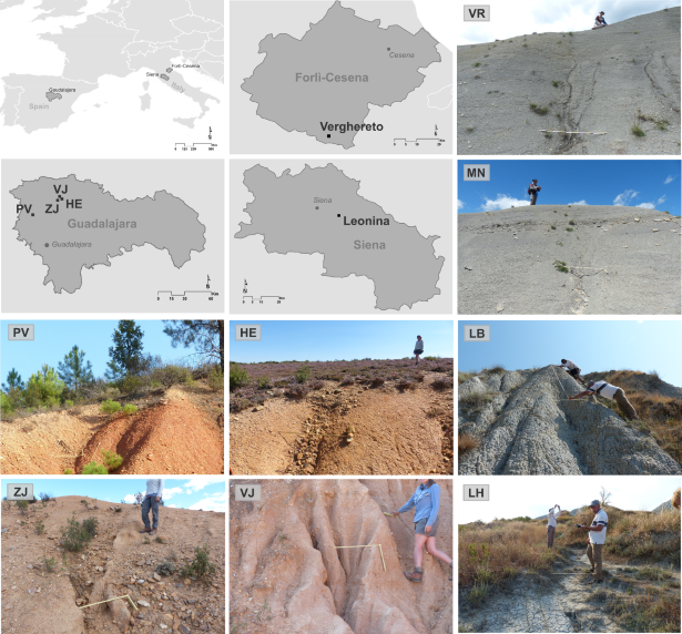
Location of study sites. Site codes in Italy: Verghereto VR, Montione MN; Leonina Biancana LH; Leonina Hillslope LB. Site codes in Spain: Puebla de Valles PV; Hiendelaencina HE; Villares de Jadraque VJ, Zarzuela de Jadraque ZJ.
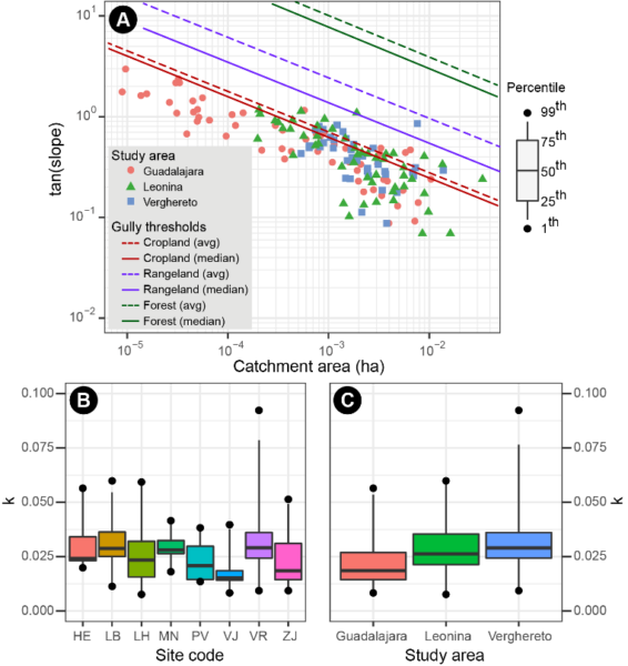
Soil surface slopes (tan slope) at the gully heads and their corresponding catchment areas (A) measured in the different badland study areas; solid and dashed coloured lines show respectively the median and average threshold trends determined for cropland (dark red), rangeland (purple), and forest (green) (Torri and Poesen. 2014). Variability of k values (equation 10) for the different badland study sites (B) and study areas (C).
Convegno sul progetto CARG: Strumento di Prevenzione dei Rischi Naturali
Lunedì 10 ottobre alle ore 9.30, dalla Sala Zuccari del Palazzo Giustiniani in Roma, sarà trasmesso in diretta streaming su https://webtv.senato.it e sul canale YouTube del Senato Italiano https://www.youtube.com/user/SenatoItaliano, il Convegno che affronta il tema del completamento del Progetto CARG (Cartografia Geologica d’Italia). Uno degli scopi dell’evento è quello di evidenziare che il Progetto è da considerarsi alla stregua di una sofisticata infrastruttura di ricerca, di fatto strategica per l’Italia, in particolare per perseguire lo sviluppo ecosostenibile e la pianificazione consapevole del territorio, per la mitigazione, riduzione e prevenzione dei rischi naturali (sismici, idrogeologici, vulcanici e geochimici), per la tutela dell’ambiente e per la gestione delle georisorse, a partire dalle quelle idriche. L’IRPI CNR sarà presente a tale iniziativa con Maurizio Polemio ricercatore presso la sede di Bari, che interverrà nel corso della diretta.
IRPI of Cosenza has participated to the event “European Researchers’ Night 2022/2023”
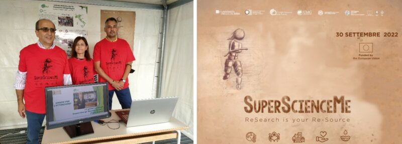
CNR-IRPI of Cosenza has participated to the European Researchers’ Night event also in the current year. The event was held in attendance on Friday, September 30, as part of the “SuperScienceMe – REsearch is your Re-source” Project, coordinated by the University of Calabria and with the participation of the CNR Institutes of Calabria and Basilicata, the University of Catanzaro “Magna Graecia”, the University of Reggio Calabria “Mediterranea” and the Calabria and Basilicata Regions.
The numerous activities planned for the event were divided into the five thematic areas inspired by the five EU Missions: Climate Change, including Societal Transformation; Cancer; Healthy Ocean, Seas, Coastal and Inland Waters; Climate-Neutral and Smart Cities; Soil Health and Food.
CNR-IRPI of Cosenza took part to the “Climate Change” thematic area by promoting two activities. The first, mainly informative, was aimed at providing information on geo-hydrological risk, also related to climate change, and how to deal with this risk. The second activity was directed to analyse how young people perceive climate change and deal with the main risks induced by it through a questionnaire downloaded via QR Code. It is possible to participate to the online questionnaire, present in the project web site, through the link www.superscienceme.it/questionario-cambiamenti-climatici-percezione-sociale.
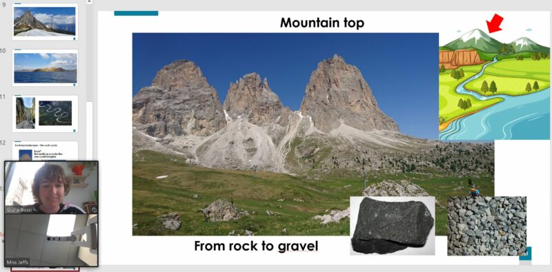
Skype a Scientist e IRPI
‘Skype a Scientist’ è un progetto internazionale di divulgazione scientifica che mira a portare brevi lezioni di studiosi di svariate materie nelle scuole. A ogni ricercatore viene assegnata una scuola a cui tenere brevi talk con discussione su temi affini alla propria ricerca, in base all’età degli alunni.
In questa cornice Giulia Bossi, ricercatrice IRPI, ha tenuto due lezioni per bambini di 7-8 anni della St Peter’s Catholic Primary School (Londra). La presentazione “From rocks to soil to rocks again” trattava del “ciclo della roccia” e dell’evoluzione del paesaggio parlando di frane, alluvioni e trasporto solido.
Researcher of CNR-IRPI elected Vice-president of IAEG
The 2022 election of the Officers of IAEG (International Association for Engineering Geology and the Environment) Executive Committee for the term 2023-2026 were held during the online International Council meeting on September 14th. Janusz Wasowski, endorsed by the Italian National Group, was elected the new Vice-president of IAEG for Europe.
Founded in 1964, IAEG is a worldwide scientific society with more than 4,500 members, 69 National Groups and 19 Technical Commissions. Currently, the Italian National Group of IAEG has 91 members, and about 20% of them are CNR Researchers, including the President of the Group, Daniele Giordan.
Can the quality of a landslide inventory be related to the visibility of the territory from the roads?
CNR/IRPI researchers in collaboration with the Geological Survey of India (GSI) and the University of the Basque Country (UPV/EHU) elaborated an experiment for the quality assessment of existing landslide inventories. The results show that inventories prepared using field survey and/or historic legacy data systematically underestimate the presence of landslides in poorly visible areas respect to the road network. This study, which can be easily replicated using the software released by the researchers, has clear implications on the procedures that, in the literature, are used to define and validate the landslide susceptibility of a territory.
More details in the the following research paper.
https://doi.org/10.5194/nhess-22-2929-2022
Due Ricercatori dell’IRPI co-autori di un recente lavoro pubblicato sulla prestigiosa rivista scientifica “NATURE”
L’articolo, intitolato “The challenge of unprecedented floods and droughts in risk management” pubblicato sulla rivista “NATURE”, presenta l’analisi di 26 coppie di eventi alluvionali e 19 di siccità occorsi in diverse parti del mondo con differenti contesti idroclimatici e socioeconomici. L’obiettivo è stato quello di valutare se e come l’occorrenza di un primo evento avesse condizionato l’impatto del secondo verificatosi a distanza di anni, utilizzando indicatori di pericolosità, vulnerabilità, esposizione, impatto e gestione del rischio.
I risultati dimostrano che quando due eventi colpiscono la stessa zona a distanza di anni, il secondo tende ad avere un impatto uguale o maggiore del primo, nonostante la realizzazione di interventi di prevenzione anche economicamente onerosi. Questa conclusione, per certi versi in controtendenza, è legata al verificarsi di eventi sempre più estremi, caratterizzati da magnitudo mai documentate in precedenza, che rappresentano ormai un allarme a scala globale soprattutto in considerazione degli scenari futuri. Solamente in due dei 45 casi analizzati, il secondo evento ha avuto un impatto più basso del primo nonostante una magnitudo più elevata, grazie al successo degli interventi di mitigazione del rischio.
L’unico caso italiano incluso nello studio, documentato dai due Ricercatori dell’IRPI Olga Petrucci e Giuseppe Esposito, è relativo ad una coppia di eventi alluvionali verificatisi in Calabria (Rossano-Corigliano). Questo caso ha evidenziato come l’impatto di un evento possa essere incrementato non solo da una maggiore magnitudo, ma anche dall’aumento di popolazione nelle zone a rischio. I due Ricercatori dell’IRPI sottolineano l’importanza di continuare a documentare gli eventi geo-idrologici, in quanto le informazioni raccolte, se adeguatamente trattate e sintetizzate sotto forma di indicatori, rappresentano validi strumenti sia per monitorare gli effetti del cambiamento climatico che per contribuire alla gestione delle azioni di adattamento e di mitigazione del rischio.
Link all’articolo: https://www.nature.com/articles/s41586-022-04917-5#MOESM1
Citazione: Kreibich, H., Van Loon, A.F., Schröter, K. et al. The challenge of unprecedented floods and droughts in risk management. Nature 608, 80–86 (2022). https://doi.org/10.1038/s41586-022-04917-5
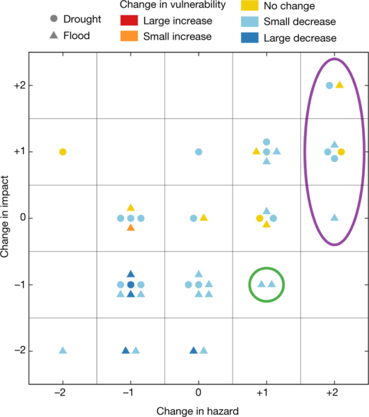
Relazione tra le variazioni di pericolosità e di impatto delle coppie di eventi alluvionali e siccitosi. Il colore dei simboli indica le variazioni della vulnerabilità, come indicato in legenda. Il cerchio verde evidenzia gli unici due casi in cui l’impatto si è ridotto nonostante l’aumento della pericolosità. Il cerchio viola evidenzia i casi associati ad impatti senza precedenti nonostante la riduzione di vulnerabilità.
Nationwide groundwater recharge evaluation for a sustainable water withdrawal over Italy. A new study published on “Journal of Hydrology: Regional Studies”
The article, titled “Nationwide groundwater recharge evaluation for a sustainable water withdrawal over Italy” has been recently published in the Journal of Hydrology: Regional Studies. The study was co-authored by Mauro Rossi & Marco Donnini from Cnr Irpi and Giulio Beddini from the University of Perugia.
In synthesis
The study evaluates over Italy the groundwater recharge, that is the amount of water that infiltrates into the soil recharging aquifers. The estimated groundwater recharge is compared with the water withdrawals for the mineral water industry and for civil use in specified years. The results show that the groundwater recharge varies regionally, mostly influenced by the precipitation distribution, elevation, and soil characteristics. Overall, the water withdrawals in Italy are sustainable in the analysed years, but not-negligible being approximately 10-15% of groundwater recharge.
In detail
The analyses were performed using the open source water balance model tool (HYDRO-BM) developed by Rossi & Donnini (2018) over a grid of 10 km × 10 km and the following gratis/libre open access data: (i) soil elevation data from the digital elevation model TINITALY/01 (https://tinitaly.pi.ingv.it/); (ii) precipitation (cumulative daily) and temperature (minimum and maximum daily) from 1981 to 2010 from the SCIA database of ISPRA (http://www.scia.isprambiente.it); (iii) soil and lithology data from the European Soil Database (https://esdac.jrc.ec.europa.eu/). The model was calibrated and validated with reference to literature data available for the area of Apennines (Central Italy). Groundwater recharge values were compared with the most recent water withdrawals data available in the scientific literature: (i) water withdrawn during 1992 for mineral water industry; and (ii) water withdrawn during 2015 for civil use.
The results shows that groundwater recharge estimated in the 1981-2010 period is on average 110 billion of cubic meters per year showing significant yearly variation. In 1992 and 2015 the groundwater recharge exceeded the average value by 3% and 27%, respectively. In 1992, the withdrawal for the mineral water industry was approximately 0.01% of the groundwater recharge and that for civil use was approximately 10% in 2015. Overall, the results show (i) that the 1981–2010 average groundwater withdrawals for civil, industrial, and agricultural use were sustainable, but not-negligible, being approximately 14% of the averaged groundwater recharge for the same period; (ii) the sustainability of water withdrawals varied regionally.
The proposed methodology allows for the evaluation of the sustainability of water withdrawals at the regional and national scale, in line with the Goal 6 of the 2030 Agenda for Sustainable Development of United Nations (“Ensure availability and sustainable management of water and sanitation for all”, see https://sdgs.un.org). Moreover, the proposed approach may have strategic importance for developing countries, which are affected by water limited availability and have sustainability issues, especially in the context of climate change.
Citation: Rossi M., Donnini M., Beddini G. (2022). Nationwide groundwater recharge evaluation for a sustainable water withdrawal over Italy. Journal of Hydrology: Regional Studies, Volume 43, 101172, ISSN 2214-5818, https://doi.org/10.1016/j.ejrh.2022.101172.
Web link: https://doi.org/10.1016/j.ejrh.2022.101172
Additional references: Rossi, M., & Donnini, M. (2018). Estimation of regional scale effective infiltration using an open source hydrogeological balance model and free/open data. Environmental Modelling & Software, 104, 153-170. https://doi.org/10.1016/j.envsoft.2018.03.005
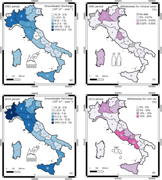
Groundwater recharge estimated in 1992 (a) and 2015 (b) and percentage of water withdrawn for mineral water industry in 1992 (c) and for civil use in 2015 (d).
IRPI is present at the 2022 IEEE International Symposium on Measurements and Networking
IRPI is present at the 2022 IEEE International Symposium on Measurements and Networking (Padova, Botanical Garden, July 18-20, 2022) with a talk entitled “Distributed optical fiber sensors for the soil temperature measurement in river embankments” presented by Luca Schenato from the Padova Branch.
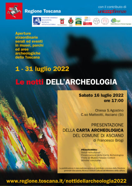
Carta Archeologica del comune di Asciano
La nuova Carta Archeologica del comune di Asciano (Siena) e le relative note, alla quale stesura hanno collaborato i tre ricercatori dell’IRPI CNR di Perugia, Mauro Rossi, Dino Torri e Giulia Margaritelli sarà presentata presso la chiesa di Sant’Agostino, Corso Matteotti, Asciano, durante la serie di eventi “Le notti dell’Archeologia”. La partecipazione è gratuita.
Luca Schenato at the international workshop on optical fiber monitoring
IRPI has attended the international workshop “SISTEMI INNOVATIVI DI MONITORAGGIO GEOTECNICO MEDIANTE SENSORI IN FIBRA OTTICA”, which has taken place in Padova, at the Botanical Garden on June 28, 2022.
In particular, Luca Schenato from the Padova Branch has presented a talk on “OPTICAL FIBER SENSORS: BASIC PRINCIPLES AND APPLICATIONS”.
Premiato Velio Coviello all’ Euromediterranean Network of Experimental and Representative Basins (ERB)
Velio COVIELLO ha ricevuto il premio “best oral presentation award” dall’Euromediterranean Network of Experimental and Representative Basins (ERB) per la presentazione “Continuous monitoring of bedload transport in a glacierized Alpine basin”. Il premio è stato assegnato in occasione della 18th Biennial Conference ERB 2022 svoltasi a Portoferraio, Isola d’Elba, dal 7 al 10 June 2022 ed organizzata dal Dipartimento di Scienze e Tecnologie Agrarie, Alimentari, Ambientali e Forestali dell’Università degli Studi Firenze. La ricerca presentata alla conferenza ERB riguarda lo studio del trasporto solido al fondo nel bacino glaciale di Solda (BZ) ed è realizzata in collaborazione con il River Basin Group della Libera Università di Bozen-Bolzano. Link al sito web della conferenza: https://www.dagri.unifi.it/p562.html
Special Issue “Atmospheric Rivers from Modeling and Remote Sensing”
This Special Issue aims to improve the current knowledge of atmospheric rivers (ARs) through the publication of groundbreaking papers that focus on innovative and original approaches to that research. From first pioneering studies, the interest of the scientific community progressively grew, as demonstrated by several funded projects on this subject, many field and numerical experiments, and the large number of scientific publications. However, despite this improvement in the knowledge of ARs in terms of their dynamics, evolution, and impact on the precipitation rate, several scientific questions remain unexplored. An example is an evaluation of the effects of AR-forced rainfall on small–medium-sized hydrological basins.
Submitted articles may address, but are not limited to, the following scientific topics:
- Impact of ARs on heavy rainfall, heavy snowfall and associated floods over the midlatitude areas.
- Changes in the hydrological response of complex terrain due to Ars.
- A special focus on the Mediterranean basin: the features, occurrence, seasonality, and effects of ARs in this complex domain.
- AR-related storms in the contest of climate change.
- ARs as a key operational product for nowcasting applications and flood risk management.
Guest Editors
Dr. Sante Laviola (CNR-ISAC), Dr. Francesco Chiaravalloti (CNR-IRPI), Dr. Annalina Lombardi (CETEMPS), Dr. Barbara Tomassetti (CETEMPS).
Deadline for manuscript submissions: 31 March 2023.
Further details can be found at the Special Issue web page
The aerial LiDAR of CNR IRPI now operational after an aerial camera and navigation system major upgrade
The CNR IRPI aerial LiDAR, (Responsible Marco Baldo of GMG – Geohazard Monitoring Group – group, based at Turin office), is operational after a major upgrade that has significantly improved its performance in terms of flight efficiency and orthophotogrammetric product resolution.
In fact, the existing aerial camera has been replaced with a new PhaseOne iXM-150Mpixel full frame (50mm focal lenght).
At the same time, the navigation and control system was updated with the new IGI CCNS5 (Computer Controlled Navigation System) model.
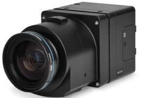
PhaseOne iXM-150 aerial camera
The medium format sensor with a pixel size of 3,76 mm, is able to shoot raw frames at a resolution of 14204X10652 pixels, corresponding to a GSD (Ground Sampling Distance) of about 6 cm / pixel at 900 meters above ground level.
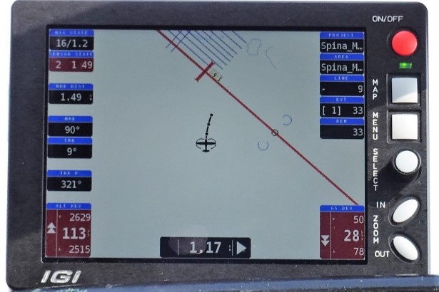
The aerial hardware control system, fully manageable with a toughpasd equipped with IGIVisu software, allows real-time viewing of stereoscopic and laser footprint coverage.
Finally, the CCNS5 flight assistance system, equipped with a full anti-reflection color display, is programmable for the aircraft on witch the system is onboarded and can predict the standard turn aerial procedures (taking into account environmental factors like direction and wind intensity), allowing a more effective entering-mode strip and saving flight time.
CCNS5 during aerial operations
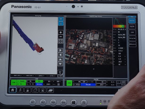
ToughPad with IGIVisu software running: real-time lidar and camera footprint
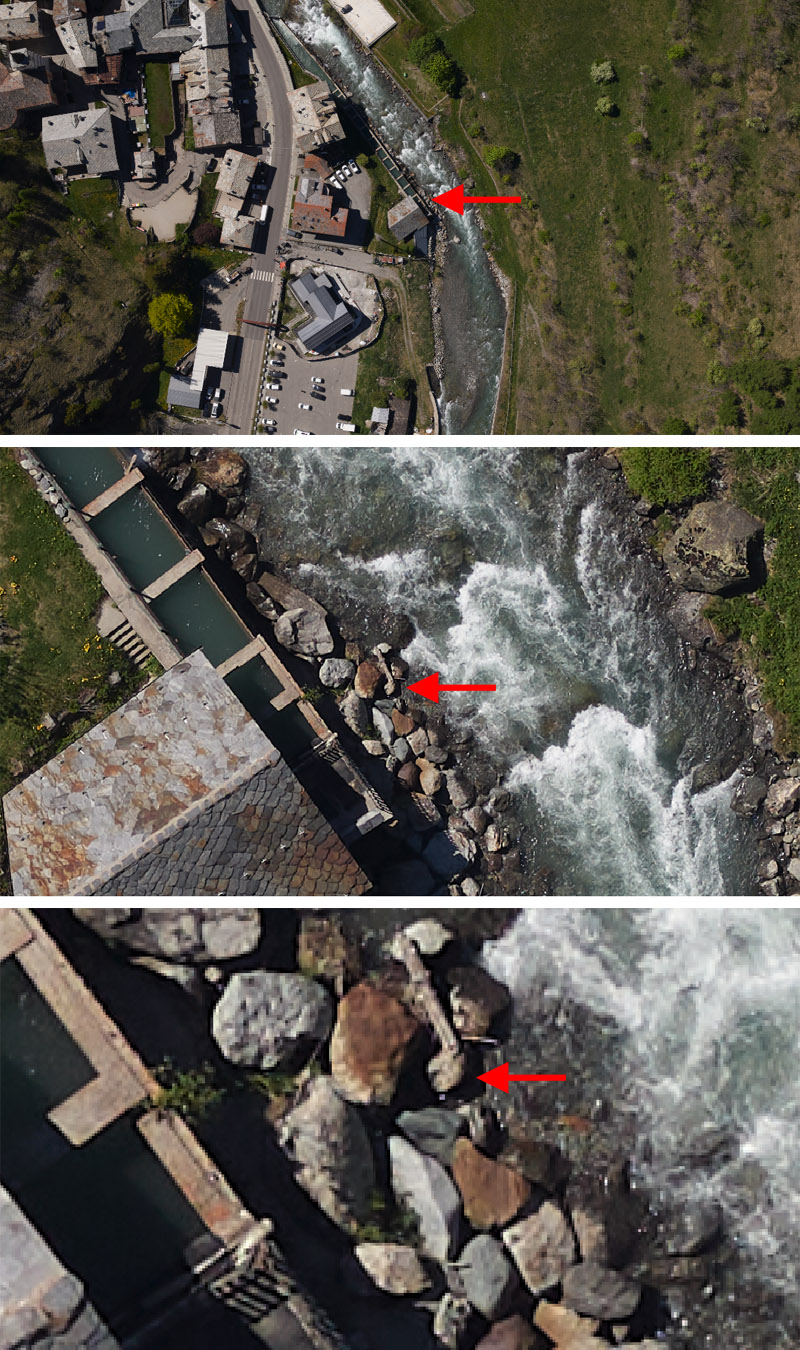
Ground resolution of an aerial shoot over Dora di Verney torrent, La Thuile village (Valle d’Aosta Region).
Per informazioni: Marco Baldo (marco.baldo@irpi.cnr.it)
Special Issue of ‘Remote Sensing’ focuses on the latest research advances in remote sensing
The Special Issue of Remote Sensing journal (IF:4.84, Cite score Scopus 6.6) on “Remote Sensing for Geohazards: Status, New Challenges and Opportunities” is currently open for submissions of full research papers and comprehensive review articles for peer review and possible publication (deadline: 30 December 2022).
The Guest Editors are: Federica Fiorucci (CNR-IRPI) e Silvia Bianchini (Dipartimento di Scienze della Terra, Università degli Studi di Firenze).
For information: francesca.ardizzone@irpi.cnr.it, federica.fiorucci@irpi.cnr.it, silvia.bianchini@unifi.it
This Special Issue focuses on the latest research advances in remote sensing technologies applied for observing, monitoring, mapping and modelling geohazards.
For further information, please follow the link to the Special Issue Website at:
https://www.mdpi.com/journal/remotesensing/special_issues/Remote_Sensing_for_Geohazards
IRPI researchers at the “Progressive Workshop on Statistical Analysis of Landslide Susceptibility”
Paola REICHENBACH and Mauro ROSSI participated to the “Progressive Workshop on Statistical Analysis of Landslide Susceptibility” at the Faculty of Mining, Geology and Petroleum Engineering of the University of Zagreb. Paola REICHENBACH and Mauro ROSSI gave lectures on topics related to landslide susceptibility modelling and carried out field surveys in the Croatian study areas. The workshop, which lasted 3 days (April 4-7, 2022), was attended by professors and PhD students from the Zagreb University. The collaborative activities were carried out within the framework of the scientific projects LandSlidePlan funded by the Croatian Science Foundation (https://landslideplan.eu/en/home/) and pri-mjer (https://pri-mjer.hr/).
Published the first dataset of flood fatalities for territories in the Euro-Mediterranean region
Scientific Data, a scientific journal of the Nature.com portfolio, yesterday (12/04/2022) published Developing a large-scale dataset of flood fatalities for territories in the Euro-Mediterranean region, FFEM-DB (https://doi.org/10.1038/s41597-022-01273-x).
The paper describes the multinational Database of Flood Fatalities from the Euro-Mediterranean region, FFEM-DB, that hosts data of 2,875 flood fatalities from 12 territories in Europe and the broader Mediterranean region from 1980 to 2020. The FFEM-DB database provides data on fatalities’ profiles, location, and contributing circumstances, allowing researchers and flood risk managers to explore demographic, behavioral, and situational factors, as well as environmental features of flood-related mortality.
The project started on 2019 after the initiative of Olga Petrucci, a researcher working at IRPI section of Cosenza, and currently it involves 24 researchers working in 12 study areas.
In the light of FAIR Principles for scientific data management, which declare that research data should be Findable, Accessible, Interoperable and Reusable, the database is freely accessible in 4TU.ResearchData, an international data repository for science, engineering and design at: https://data.4tu.nl/articles/dataset/EUFF_2_0_European_Flood_Fatalities_database_/14754999.
The future plan is to extend the database to all the European countries. Researchers working on the impact of floods on countries of the Euro-Mediterranean region can participate to the enlargement of the database with data about flood fatalities occurred in their country in the period 1980-2020.
contact: olga.petrucci@irpi.cnr.it.
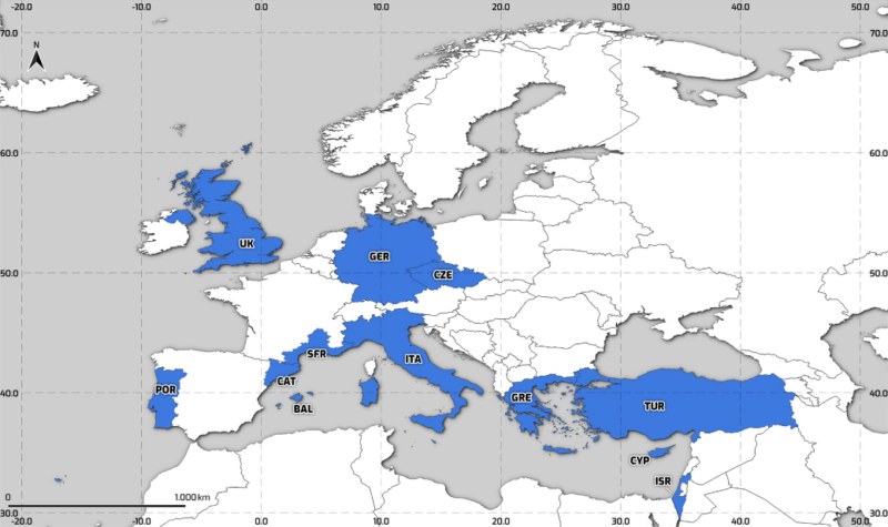
FFEM-DB study areas, in blue. BAL: Balearic Islands; CAT: Catalonia; CYP: Cyprus; CZE: Czech Republic; SFR: Southern France; GER: Germany; GRE: Greece; ISR: Israel; ITA: Italy; POR: Portugal; TUR: Turkey; and UK: United Kingdom.
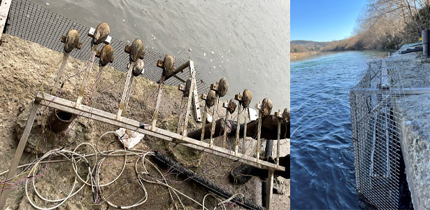
Monitoring systems with mussels in cages operative at the Orvieto river section, Paglia River (ENTERPRISING PRIN project)
Two monitoring systems with mussels in cages have been made operative at Orvieto gauged site on March 31st and on April 7th 2022 (Paglia River) in the context of the PRIN ENTERPRISING project.
One system is installed on the pile of the bridge and one is in a lateral pool under the bridge. The systems allow to compare the mussels’ opening with the water level, conductivity and temperature with the main aim to identify the interactions between hydrodynamics and biotic communities.
Launching of the executive program for scientific and technological cooperation between Italy and India (2022-2024)
IRPI-CNR participates in the bilateral program as an Italian partner of the ‘Significant Research Project’: Probabilistic floods and sediment transport forecasting in the Himalayas during the extreme events.
PI: Dr Silvia Barbetta
Un minuto di silenzio, guardandoci negli occhi
Nella giornata dell’8 marzo, il Cnr-Irpi si è unito al minuto di silenzio a seguito delle parole della presidente del Cnr, Maria Chiara Carrozza: “Martedì 8 marzo, alle ore 13, tutta la comunità del Cnr è invitata ad osservare un minuto di silenzio ritrovandosi negli spazi antistanti la propria sede lavorativa. Un minuto nel quale, oltre ad esprimere solidarietà per il popolo ucraino – e per tutti i popoli attualmente vittime di guerre e ingiustizie – ci si possa riconoscere come parti di un tutto, come compagni di viaggio, uniti nella pace e nella fiducia per il progresso dell’umanità. Con un pensiero solidale in più in occasione della Giornata Internazionale dei diritti della donna”. Si riportano le foto delle sedi di Perugia, Cosenza e Padova. Le Sedi di Bari e Torino hanno partecipato al momento insieme agli Istituti afferenti alle rispettive Aree di Ricerca.


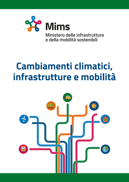
SANF-RFI prototipo di sistema di allertamento per le infrastrutture di trasporto riconosciuto dal Mims
Il sistema di allertamento da frana SANF-RFI, sviluppato da Irpi Cnr per l’infrastruttura ferroviaria gestita da RFI, citato nel rapporto “Cambiamenti climatici, infrastrutture e mobilità” del Mims.
SANF-RFI è un sistema di allerta per la previsione di frane pluvio-indotte lungo l’infrastruttura ferroviaria gestita da RFI. Il sistema utilizza misure e previsioni quantitative di pioggia per prevedere l’occorrenza spaziale e temporale di frane lungo l’infrastruttura.
Il sistema è stato sviluppato a partire dalle precedenti esperienze che hanno portato alla implementazione di prototipi sia a scala nazionale, per conto del Dipartimento di Protezione Civile, che a scala regionale per le regioni Liguria, Sardegna e Puglia. SANF-RFI rappresenta un ulteriore sforzo, che mette a sistema le competenze di mappatura, modellazione e sviluppo tecnologico che il gruppo di ricerca ha maturato nel suo pluridecennale impegno istituzionale. Il sistema, in quest’ultima configurazione, prevede non solo l’occorrenza delle frane ma ne stima il possibile impatto sulla rete ferroviaria.
Nel rapporto “Cambiamenti climatici, infrastrutture e mobilità: soluzioni e strategie per gli investimenti infrastrutturali in un contesto di adattamento ai cambiamenti climatici e di mitigazione delle emissioni di gas-serra” redatto dalla Commissione cambiamenti climatici infrastrutture e mobilità sostenibili del Mims (Ministero delle Infrastrutture e della mobilità sostenibile), il SANF-RFI è stato citato come un “primo passo verso la definizione di interventi di early warning per le infrastrutture di trasporto”.
In particolare tali strumenti, anche secondo quanto specificato nel rapporto, sono da considerarsi come misure di adattamento di tipo soft ai cambiamenti climatici, in quanto utili a ridurre gli impatti che i fenomeni geo-idrologici pongono sulle infrastrutture e sulla popolazione.
Quanto riportato dal rapporto riconosce l’impegno decennale dei ricercatori del gruppo di Geomorfologia dell’Irpi di Perugia, e in particolare del team di sviluppo dei sistemi di allertamento territoriale, finalizzato alla previsione di fenomeni geo-idrologici di versante, combinando competenze scientifiche e di innovazione ai fini di Protezione Civile.
RIFERIMENTI SITO MIMS
https://www.mit.gov.it/nfsmitgov/files/media/notizia/2022-02/Rapporto_Carraro_Mims.pdf
Il Gruppo Gestione dei Rischi Geologici partecipa ad un nuovo progetto
Il Geo-Risk Management Group partecipa al progetto “Numerical simulation and risk analysis of landslide hazard chains in high-mountain Asia considering the effects of global climate change” finanziato dall’ANSO (Alliance of International Science Organizations) e coordinato dal Prof. Gongdan Zhou dell’Insitute of Mountain Hazard and Environment (IMHE), CAS e del Sino-Italian Joint Laboratory on Geological and Hydrological Hazard di Chengdu. Oltre all’IRPI e all’IMHE partecipano al consorzio di ricerca l’ICIMOD (Centre for Integrated Mountain Development, Pakistan) con la dott.ssa Mandira Singh Shrestha e la Technical University of Munich con il Prof. Shiva P. Pudasaini.
Il progetto si ripropone di investigare i processi di instabilità in ambiente proglaciale e periglaciale con particolare attenzione ai fenomeni di sbarramento e ai possibili conseguenti “outburst floods” nelle regioni più elevate dell’Asia, attraverso rilievi diretti, modellazione fisica e numerica. Il risultato finale sarà un modello dinamico multirischio con lo sviluppo di un software per l’analisi del rischio e la sua mitigazione nei settori interessati dal progetto “Belt and Road Initiative”.
Il contributo del Cnr-Irpi al sistema paese per la mitigazione dei rischi geo-idrologici
Venerdì 26 novembre si è concluso il workshop dell’Istituto di ricerca per la protezione idrogeologica, Cnr-Irpi, dal titolo “Il contributo del Cnr-Irpi al sistema paese per la mitigazione dei rischi geo-idrologici”, organizzato presso la Sala convegni della sede del Cnr in piazzale Aldo Moro a Roma in occasione dei 50 anni di attività dell’Istituto. A seguito dell’alluvione di Firenze del 1966, nel novembre del 1970, vennero istituite le prime tre sedi autonome del Cnr-Irpi, a Perugia, Torino e Cosenza, e alle quali si sono aggiunte negli anni successivi quelle di Bari e di Padova. Dal 2001 le sedi autonome sono state riunite in un unico istituto con sede centrale a Perugia alla quale si affiancano le altre quattro sedi.
Il workshop, inaugurato ieri 25 novembre, si è articolato in 4 sessioni tematiche che, tra interventi in presenza e in remoto, si sono susseguite nelle due giornate. La prima è stata dedicata alle tecnologie e ai sistemi per il monitoraggio e la previsione dei fenomeni geo-idrologici, la seconda alle ricerche svolte per la caratterizzazione e l’analisi dei processi che sono alla base della formazione dei fenomeni geo-idrologici. La terza e corposa sessione ha indirizzato gli avanzamenti fatti nei settori che abbracciano la valutazione della pericolosità geo-idrologica, la stima dei possibili impatti e la definizione delle misure di mitigazione dei rischi in un contesto di cambiamento globale. La quarta sessione è stata dedicata al tema della comunicazione dei rischi geo-idrologici e delle relative incertezze, comunicazione che si rivolge non solo agli addetti ai lavori, ma anche a un più ampio pubblico con la finalità di sensibilizzare i cittadini alle problematiche del dissesto geo-idrologico.
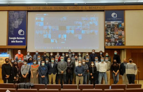
Alcuni dei ricercatori e dei tecnologi Irpi protagonisti dell’evento
Le sessioni hanno rappresentato le molteplici attività svolte dall’Istituto, la cui missione è quella di promuovere l’avanzamento della conoscenza sui processi che sono alla base della formazione dei rischi geo-idrologici al fine di individuare misure adeguate per la protezione territoriale e ambientale, e nonché per lo sfruttamento sostenibile delle geo-risorse. Sono stati presentati i risultati finora ottenuti dall’Istituto nel campo del monitoraggio e della previsione dei fenomeni geo-idrologici, nella determinazione del loro impatto al suolo e della mitigazione e nonché dell’effetto del cambiamento climatico su tali fenomeni.
I lavori sono stati aperti nella mattina del 25 novembre dal direttore dell’Istituto, Tommaso Moramarco, che ha poi lasciato la parola ai suoi predecessori, Lucio Ubertini, Fausto Guzzetti e Alessandro Pasuto. Gli interventi successivi del presidente della Commissione grandi rischi, Gabriele Scarascia Mugnozza, e del direttore del Dipartimento scienze del sistema terra e tecnologie per l’ambiente del Cnr, Fabio Trincardi, hanno evidenziato il ruolo chiave dell’istituto nella ricerca sui rischi geo-idrologici, a livello nazionale ed internazionale.
“Nei suoi 50 anni di attività l’Irpi ha contribuito alla sicurezza geo-idrologica del nostro Paese favorendo adeguate misure di mitigazione del rischio, mediante l’avanzamento della conoscenza sui processi che sono alla base dei fenomeni naturali potenzialmente pericolosi”, queste le parole con le quali il Direttore ha aperto il discorso di inaugurazione. Il discorso ha poi toccato i vari momenti della vita dell’istituto e il suo ruolo nella ricerca internazionale, ricordando anche gli sforzi messi in campo a supporto delle amministrazioni impegnate sia nella pianificazione che nella gestione territoriale. Infine l’ingegnere Moramarco ha sottolineato il ruolo centrale dell’istituto quale Centro di competenza del Dipartimento nazionale della protezione civile sui rischi geo-idrologici, ed in particolare sul rischio da frana e da inondazione.
Modelling seasonal variation of gully erosion at the catchment scale. A new study published on “Earth Surface Processes and Landforms” Journal
The article, titled “Modelling seasonal variation of gully erosion at the catchment scale” has been recently published in the journal Earth Surface Processes and Landforms. The study proposes a method for integrating remote sensing data from the ESA Sentinel-2 mission and the LANDPLANER modelling tool developed by Mauro Rossi, to predict the spatial and temporal occurrence of gully erosion phenomena. The study investigates the seasonal conditions responsible for the triggering of such phenomena at the basin scale using different erosion modelling schemas. The results show how the occurrence of erosion phenomena in the studied region changes seasonally, and that the proposed method was able to effectively discriminate the spatial and temporal occurrences of such phenomena. The proposed method can be applied to regions with similar characteristics around the world, even where there is limited data availability. The study was developed under the Project “SAPERE – Space Advanced projectExcellence in Research and Enterprise” and Project BIOESSaNS “Biodiversity and ecosystem services in SacredNatural Sites”, both funded by the Italian Ministry of Education, University and Research (MIUR).
Citation: Agostini, M., Mondini, A.C., Torri, D. & Rossi, M. (2021) Modelling seasonal variation of gully erosionat the catchment scale. Earth Surface Processes and Landforms,1–23. Available from: https://doi.org/10.1002/esp.5259.
Web links: https://doi.org/10.1002/esp.5259
50 anni di attività dell’Istituto di Ricerca par la Protezione Idrogeologica
In occasione del suo cinquantesimo anno di attività, l’Istituto di Ricerca par la Protezione Idrogeologica del CNR (IRPI CNR), ha deciso di realizzare un Workshop dal titolo “Il contributo del Cnr-Irpi al sistema paese per la mitigazione dei rischi geo-idrologici”.
L’evento avrà luogo dal 25/11/2021 ore 10.00 al 26/11/2021 ore 17.00 presso la Sala convegni della sede del CNR – Piazzale Aldo Moro, Roma – ed interesserà la gran parte dei Ricercatori e Tecnologi delle varie sedi dell’Istituto. Il workshop si svolgerà in presenza con l’opportunità di seguirlo in videoconferenza per coloro che saranno opportunamente registrati.
Memorandum of Understanding between IRPI CNR and the Institute of Earth Exploration and Sensing, Najing University (China)
On November 19 (2021), a Memorandum of Understanding (MoU) between IRPI CNR and the Institute of Earth Exploration and Sensing, Najing University (China), a collaborative project that involves the two Parties for a period of five years, has been signed. The objective of the MoU is to establish a collaborative framework for joint R&D activities in the areas of interest of the two Parties, and specifically for the development of (i) fiber optic sensing technologies for engineering geological and geotechnical problems; (ii) real-time monitoring, early warning, and risk assessment systems for geohazards mitigation; (iii) artificial intelligence technologies in geotechnical and geological engineering.
The Institute of Earth Exploration and Sensing appointee: dr. Hong-Hu Zhu (zhh@nju.edu.cn)
CNR-IRPI appointee: dr. Luca Schenato (schenato@cnr.it)
CNR IRPI attends, in presence, to the Kick-Off of the I-CHANGE project
CNR IRPI attends, in presence, to the Kick-Off of the I-CHANGE project (Individual Change of HAbits Needed for Green European transition – 25-26 November 2021). The event takes place in Savona, at CIMA Foundation headquarters. The 3.5 years project is funded by the European Union (HORIZON 2020), is led by the University of Bologna and CIMA Research Foundation and involves 16 partners from 12 different countries. IRPI represents the CNR together with other institutes (IAA, IMATI, IGAG). Researchers Ivan Marchesini, Paola Salvati, Giuseppe Esposito and Alessando Mondini are involved in the project.
(In the photo presentation of Ivan Marchesini researcher of the IRPI CNR)
Conferenza Bilaterale tra il Cnr-Irpi e il Ministero dell’Ambiente, Infrastrutture, Trasporti e Turismo del Giappone
Mercoledì 24 novembre dalle 8:00 alle 12:00 si terra la XII conferenza Bilaterale tra Italia e Giappone sulla previsione e prevenzione dei rischi naturali nell’ambito della collaborazione, che dal 1998 lega l’Istituto di Ricerca per la Protezione Idrogeologica del Consiglio Nazionale delle Ricerche (CNR-IRPI) ed il Ministero dell’Ambiente, Infrastrutture, Trasporti e Turismo (MLIT) del Giappone.
I temi di tale collaborazione sono essenzialmente correlati al dissesto idrogeologico e ai possibili interventi di mitigazione. L’incontro intende rappresentare un momento di confronto tra ricercatori e tecnici giapponesi e italiani su tre specifici temi: i cambiamenti climatici e le frane; la gestione delle opere di mitigazione strutturale e la gestione del rischio vulcanico. Quest’ultima tematica, espressamente introdotta per la prima volta dalla controparte giapponese rappresenta un importante occasione per un allargamento della cooperazione con il coinvolgimento di ricercatori dell’INGV.
Ricercatori IRPI al convegno “Il monitoraggio delle frane per la gestione dei rischi naturali”
I ricercatori del CNR IPRI Velio Coviello e Daniele Giordan sono fra i relatori del convegno “Il monitoraggio delle frane per la gestione dei rischi naturali” organizzato da ARPA Lombardia, dove verranno affrontati gli aspetti legati ai sistemi di monitoraggio delle frane e di allertamento oggetto delle nuove Linee Guida Snpa. L’accesso alla sala sarà consentito ad un numero limitato di partecipanti ma l’evento sarà trasmesso in diretta streaming.
Paola Reichenbach nominata componente del Comitato nazionale per la valutazione della ricerca
Paola Reichenbach è stata nominata dal Ministro del MUR, Prof.ssa Maria Cristina Messa, componente del Comitato nazionale per la valutazione della ricerca (CNVR), istituito ai sensi dell’art. 64, decreto legge 31 maggio 2021, n. 77.
Il CNVR esercita le seguenti funzioni principali:
a) indica i criteri generali per le attività di selezione e valutazione dei progetti di ricerca, secondo canoni di imparzialità e tenendo nella massima considerazione le raccomandazioni approvate da organizzazioni internazionali di cui l’Italia è parte, nonché ispirandosi alle migliori pratiche applicate nei programmi dell’Unione europea;
b) nomina i componenti dei comitati di valutazione, ove previsti dai decreti attuativi applicabili ai fondi per il finanziamento di progetti di ricerca;
c) provvede allo svolgimento, anche parziale, delle procedure di selezione dei progetti o programmi di ricerca di altri enti, pubblici o privati, previo accordo o convenzione con essi;
d) definisce i criteri per l’individuazione e l’aggiornamento di liste di esperti tecnico-scientifici e professionali per l’affidamento di incarichi di valutazione tecnico-scientifica dei progetti di ricerca, istituite con decreto del Ministro dell’università e della ricerca;
e) predispone rapporti specifici sull’attività svolta ed una relazione annuale in materia di valutazione della ricerca, che trasmette al Ministro, il quale cura la pubblicazione e la diffusione dei rapporti e delle relazioni del CNVR.
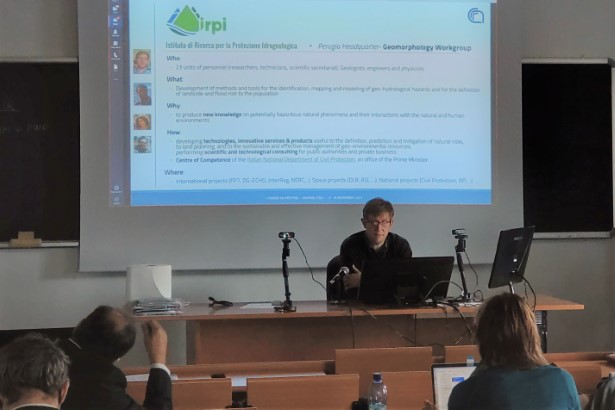
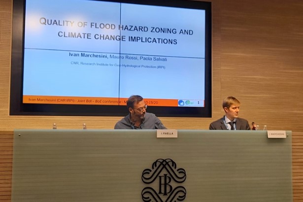
L’IRPI alla conferenza di ricerca congiunta Banca d’Italia-Bank of England
I ricercatori Ivan Marchesini, Mauro Rossi e Paola Salvati del CNR-IRPI, sede di Perugia, partecipano alla Conferenza di ricerca congiunta Banca d’Italia-Bank of England “The macro-financial impacts of climate change and the net-zero transition”, che in questi giorni si sta tenendo a Milano, con la presentazione Quality of flood hazard and climate change implicaton.
Nella foto Ivan Marchesini al tavolo dei relatori.
European Geosciences Union General Assembly 2022: parallel session convened by CNR IRPI staff
Next European Geosciences Union – EGU – General Assembly will be held in Vienna, April 3-8, 2022. The EGU General Assembly 2022 brings together geoscientists from all over the world to one meeting covering all disciplines of the Earth, planetary, and space sciences. The EGU aims to provide a forum where scientists, especially early career scientists, can present their work and discuss their ideas with experts in all fields of geoscience.
The session convende by researchers of CNR IRPI, in collabration with scientists of different Istitutions from various countries, is entitled Novel data, methods and applications in Geomorphometry. Geomorphometry, a science of quantitative land surface analysis, gathers various mathematical, statistical and image processing techniques to quantify morphological, hydrological, ecological and other aspects of a land surface. The typical input to geomorphometric analysis is a square-grid representation of the land surface: a digital elevation model (DEM) or one of its derivatives. DEMs provide the backbone for many studies in Geo sciences, hydrology, land use planning and management, Earth observation and natural hazards.
The session is aimed at gathering contributions in the following main topics:
1 – Compromises between the use of global DEMs at 1-3 arc second, ~30-90 m grid spacing, and local LiDAR/structure from motion (SFM) elevation models at 1 m or finer grid spacing. We would like to investigate the tradeoff between the employment of the two kinds of data, and applications which can benefit from data at both (local and global) scales.
2 – New analytical methods and advanced geo-computation techniques, necessary to cope with diverse application contexts. We aim at investigating new methods of analysis and advanced geo-computation techniques, including high-performance and parallel computing implementations of specific approaches.
3 – Commercial anmd industrial applications of DEM data and of geomorphometric techniques. We would like to survey and investigate professional, commercial and industrial applications, including software packages, from small enterprises to large companies, to ascertain how academic researchers and industry can work together.
Details on the session at EGU 22 are available here: https://meetingorganizer.copernicus.org/EGU22/session/43941
The latest topical Geomorphometry conference: http://geomorphometry2021.org
Contacts: Massimiliano Alvioli (massimiliano.alvioli [AT] irpi.cnr.it)


