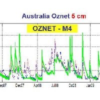
The service aims to assess the potential of different satellite products (from active and passive micro-waves, optical, SAR, spectroradiometers, radiometers sensors) in retrieving the main hydrological-hydraulic variables such as rainfall, soil moisture, water level, flow velocity and discharge. This is pursued through a comprehensive validation analysis by using in-situ observed or modelled data for several sited located ...
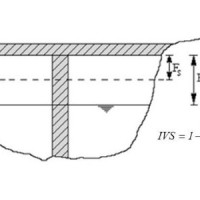
Assessment of bridge piers/abutments vulnerability to scour and overtopping hazard, assessment of levee vulnerability to seepage and overtopping hazard. The analysis is based on clearly identified criteria. Specifically, overtopping (IVS) and erosion (IVE) vulnerability indices are evaluated for each selected bridge, and the overtopping (IVsorm) and seepage vulnerability indices (IVsif) are calculated for the ...
The study of the evolution of the territory and especially of the of geo-hydrological instabilities can be often based on the use of high resolution digital terrain models. The possibility to make ad hoc surveys and repeat them over time can be useful for the identification and measurement of the topographic effects of a particular morphological process. LiDAR can be usually considered the best solution for the creation of high resolution DEM. ...
