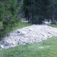
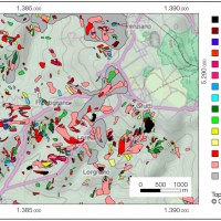
This catalog presents a dataset of 809 debris flows that occurred in 537 basins in mountainous areas of northeastern Italy between the mid-19th century and 2016. The region considered covers an area of approximately 22,000 km2.
For each record, debris-flow volume, date of occurrence, drainage basin area, and the geographical coordinates of the basin outlet are reported.
The sources of debris-flow volume data are classified into four classes: ...

Making reports of rockfall in the area affected by the earthquake in central Italy in ...
The dataset includes precipitation, temperature and discharge data recorded in the Missiaga catchment (Dolomites). The Missiaga catchment was monitored by CNR IRPI from 1983 to ...
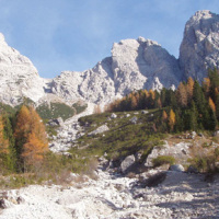
This dataset consists of rainfall data and debris-flow hydrographs recorded in the Moscardo Torrent (Carnic Alps, northeastern Italy).
The Moscardo Torrent was instrumented for debris-flow monitoring by CNR IRPI (Torino office) in 1989; the research was then continued in collaboration with the Padova office. Since 2010 the monitoring activities are carried on in collaboration with the University of Udine (Dept. of Agricultural and ...

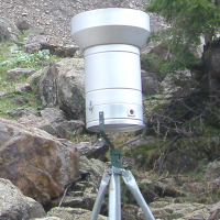
The 3DA software is a new procedure that allows retrieving in near-real-time 3D surface deformation models starting from data acquired via robotized total stations or others system that acquire the surface displacements. The measurements are first pre-processed and then implemented on 3D maps that include vector arrows representative of the intensities and of the real directions of motion in a given system of coordinates. The 3D surface ...
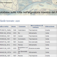
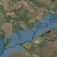
This is the web-based relational database on the main levee breaches of the Po River (Italy), which have occurred since the year 1800.
The database contains more than 200 fact sheets that show the information for each levee failure. For each fact sheet are attached documents and maps. The access is free of charge.
This database may provide a valid support in the design of defense interventions directed at the prevention and mitigation of ...
The database includes annual maximum rainfall corresponding to durations of 1, 3, 6, 12, 24 hours and 1, 2, 3, 4, 5 days for approximately 800 raingauges in north-eastern Italy (Trentino, Alto Adige, Veneto and Friuli Venezia Giulia). The database contains data until 1997 for the Autonomous Province of Bozen-Bolzano, 1990 for the Autonomous Province of Trento, and 1996 for Veneto and Friuli Venezia ...
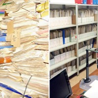
ARCO is the historical archive concerning the geo-hydrological events that occurred in Calabria (south Italy) between 1850 and 1990. The archive is made of 506 folders. 45 folders contain projects of land reclamation, management works of fluvial basins and refunding requests carried out after earthquakes. 461 folders, sorted per municipality, contain refunding requests due to geo-hydrological events, communications between citizens and public ...
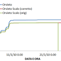
The analysis of hydro-meteorological data is required to verify the correct sensors functioning and possible presence of non-operational periods with missing data. When non-operational periods or malfunction occur, it could be possible to apply procedures for missing data reconstructions and wrong data ...
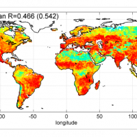
The rainfall dataset provides rainfall estimates obtained through the application of an inversion algorithm to soil moisture data. The algorithm has been applied to ground and satellite data, obtained through various satellite ...
Hydraulic hazard maps for return periods of 50, 100, 200 and 500 ...

The study of the evolution of the territory and especially of the of geo-hydrological instabilities can be often based on the use of high resolution digital terrain models. The possibility to make ad hoc surveys and repeat them over time can be useful for the identification and measurement of the topographic effects of a particular morphological process. LiDAR can be usually considered the best solution for the creation of high resolution DEM. ...
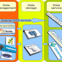
We provide maps and layers through standard OGC services and WebGIS applications.
Our aim is to disseminate information on landslides and floods hazards and the related risk.
More specifically the services focus on thematic data concerning landslides and floods, including: (i) landslide inventory maps at different scales and covering different geographical areas, (ii) landslide susceptibility, hazard and risk maps, and (iii) information on ...
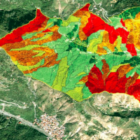
A landslide susceptibility map forecasts where landslides are expected to occur in the future based on terrain conditions, including local morphological, geological, and land use settings. Using different colors, a landslide susceptibility map shows forecasted levels of landslide susceptibility in a region. Using specific software, LSMMs can be prepared whene new landslides or new environmental (e.g., morphological, geological, land use) data ...
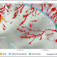
An Event Landslide Inventory Map (ELIM) shows the location and extent of landslides caused by a specific natural trigger, such as an intense rainfall event, a period of prolonged rainfall, a rapid snowmelt event, or an earthquake. The methods and tools developed by CNR-IRPI allow preparation of an ELIM anywhere recent landslides have left discernible ...
A Landslide Inventory Map (LIM) shows the location, spatial extent and type of landslides in a ...
