Description
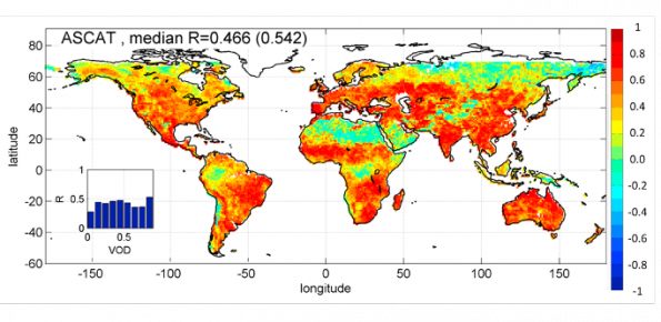
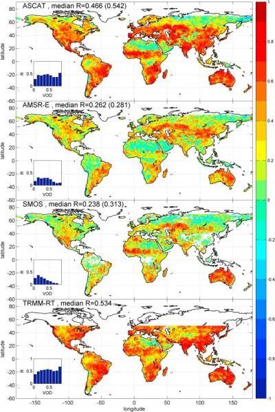
The rainfall dataset provides rainfall estimates obtained through the application of an inversion algorithm to soil moisture data. The algorithm has been applied to ground and satellite data, obtained through various satellite sensors.
Users/Purpose
- Local Civil Protection authorities (municipal, regional, functional centers) and the National Department of Civil Protection as input for the hydrological modeling for the daily geo-hydrological risk assessment.
- National and international universities and research institutes interested in developing, improving and comparison of satellite rainfall data and in using satellite data as input for forecasting models (landslide events, flooding phenomena…)
- Developers and providers of meteorological data interested in improving of the retrieval and assessment procedures with respects to the provided product.
Methods and technologies
The algorithm is based on the inversion of the soil water balance equation. As input, it uses soil moisture time series and three parameters to be estimated through calibration. From the knowledge of the soil moisture difference between two measures, it is possible to estimate the rainfall depth in the time interval of interest.
Products
The dataset is provided with different spatial resolution (0.125°, 0.25°, 0.5°, 1°).
http://hydrology.irpi.cnr.it/repository/public/files/sm2rain-global-rainfall-datasets
Link to the new dataset »