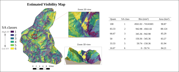
Can the quality of a landslide inventory be related to the visibility of the territory from the roads?

CNR/IRPI researchers in collaboration with the Geological Survey of India (GSI) and the University of the Basque Country (UPV/EHU) elaborated an experiment for the quality assessment of existing landslide inventories. The results show that inventories prepared using field survey and/or historic legacy data systematically underestimate the presence of landslides in poorly visible areas respect to the road network. This study, which can be easily replicated using the software released by the researchers, has clear implications on the procedures that, in the literature, are used to define and validate the landslide susceptibility of a territory.
More details in the the following research paper.
https://doi.org/10.5194/nhess-22-2929-2022