Remotely Piloted Aircraft Systems for emergency response
Use of Remotely Piloted Aircraft Systems (RPAS) during seismic emergency for the evaluation of road exposure due rockfalls

The use of remotely piloted aircraft systems (RPASs) in geosciences is often aimed at the acquisition of an image sequence to produce digital models and orthophotographs of the topographic surface. Such photogrammetric technique can be applied for rockfall hazard and risk assessment. To study rockfalls, an approach consists in the application of numerical models for the computation of rockfall trajectories. Data required for such simulations include digital terrain models, location of the instability source areas, and the mechanical properties of the terrain. In this work, it is carried out an analysis of the earthquake-triggered rockfall that occurred along the SP18 in Villanova di Accumoli (Lazio, central Italy) during the seismic sequence that started on 24 August 2016.
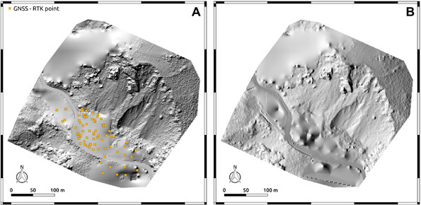
A survey with a multicopter was carried out to obtain a surface model of the terrain and identify and characterize the source areas and other instable blocks in areas not accessible in the field. The investigated area extends for 6500 m2 and was covered by 161 photographs that were used to obtain an orthophoto with a ground resolution of 2.5 cm and a digital surface model with a ground resolution of 20 cm × 20 cm. Vegetation and anthropic artifacts were filtered out from the DSM, obtaining a DEM through the integration of radiometric filters and a manual cleaning. In the wooded area between the cliff and the road, where no data was available through the RPAS acquisition, real time kinematic GNSS (RTK) data were collected and then merged to the DEM. The final DEM was then resampled at a ground resolution of 1 m. To obtain a map of potential rockfall trajectories, we run the numerical model STONE, using as origin of the boulders both source areas mapped in the field and DEM cells with a slope angle greater than 60°, according to field observations. To take into account possible errors in the GNSS point measurements, the elevation values were altered according to a Gaussian distribution (with an average of 0 and a standard deviation of 0.25) to obtain 100 sets of points. Each set was interpolated obtaining 100 DEMs of the wooded area. The simulation using STONE was then performed 100 times (one for each DEM) initiating 100 trajectories from each “source” cell.
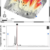
Results showed that only the part of the road SP18 already affected by the rockfall was exposed to further rockfall impacts. In particular, it was observed that 29.2 % (12,123) of the 41,500 simulated trajectories may potentially reach or cross this tract of the road. Based on these data, limited protection measures were suggested. The combined use of RPAS data, fused with ground GPS points, an accurate geomorphological survey, and terrain static and dynamic parameters from the literature allows fast, low-cost, and replicable rockfall numerical modelling useful for emergency response and adoption of proper protection measures.
Results
The activity, carried out during the 2016 earthquake sequence in Accumoli (central Italy), made it possible to establish safe reopening conditions for a portion of a road close to a cliff. Due to earthquake shaking, blocks of about one cubic meter detached and reached the SP18 close to the hamlet of Villanova. Although the technologies and models used for the study were already well established, results are relevant because the tight time schedule during the seismic emergency phase led to the implementation of a procedure that integrates different methods usually not jointly applied.
Granting institutions
The work was partly funded by the Italian National Department of Civil Protection.
To know more
Santangelo M., Alvioli M., Baldo M., Cardinali M., Giordan D., Guzzetti F., Marchesini I., Reichenbach P. (2019). Brief communication: Remotely piloted aircraft systems for rapid emergency response: road exposure to rockfall in Villanova di Accumoli (central Italy). Nat. Hazards Earth Syst. Sci., 19, 325–335. https://doi.org/10.5194/nhess-19-325-2019.


 Contact person: michele santangelo -