Filters
43 focus found

Surface–groundwater interactions in mountain catchments
Surface–groundwater interactions represent a key component in understanding hydrogeological systems, particularly in mountain catchments, where groundwater contributions to streamflow are often dominant and play an increasingly important role in water...
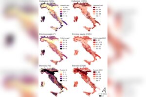
Geotechnical Parameterisation of the Lithological Map of Italy
The dataset of geotechnical parameters for Italian lithotypes was created through a systematic review of international literature. Researchers compiled over 2300 geotechnical records by analyzing peer-reviewed articles from databases like...

The mechanism triggering landslides on Ceres has been identified
A collaborative study by CNR IRPI, Geoservizi Srl and the universities of Trento and Chieti-Pescara has revealed the mechanisms that trigger landslides on Ceres, a dwarf planet in the asteroid...

Landslide susceptibility zoning through physically-based limit equilibrium method modelling
The work introduces an innovative physically based framework for large-scale landslide susceptibility assessment, combining limit equilibrium analysis with spatialisation strategies and statistical classification techniques. The methodology, applied to a case...
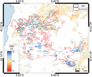
Large-scale observation of reduced soil permeability in areas affected by extreme wildfires
A team of female and male researchers from the Institute for Research on Hydrogeological Protection (Cnr-Irpi) analyzed the effects of an extreme wildfire on soils and low vegetation using multitemporal...

The exceptional ice-rock avalanche of Blatten in Valais (CH)
On 28 May 2025, at15:24 (CEST), the frontal part of the Birch Glacier in Valais (CH), estimated at around 3 million m3, collapsed, dragging with it over 6 million m3...

Which characteristics should optical satellite images have to detect and map landslides? It depends …
Landslides leave discernible signs on the land surface, most of which can be captured in remote sensing images. On the images the signs appear as modification of the photographic characteristics...

Effects of climate change on landslides
Worldwide, landslides pose a serious threat to the population, causing fatalities, widespread damages, and significant economic losses. Different phenomena influence the stability of slopes and can cause landslides, among which...

Remotely Piloted Aircraft Systems for emergency response
The use of remotely piloted aircraft systems (RPASs) in geosciences is often aimed at the acquisition of an image sequence to produce digital models and orthophotographs of the topographic surface....

Aerial LiDAR for research activities
The LiDAR sensor available to the institute has recently turned seven years since the first survey executed on November 2, 2011, in the aftermath of the flood event that affected...

River discharge estimation from satellite
River discharge is defined as the amount of water flowing through a river over a specified period of time. Its estimate is crucial for all the operations of hydraulic structures...

The improvement of the expressive and learning abilities of the adult
The researches and the experimentations carried out, in the learning field, by the IRPI Institute during the last years, started out initially in the field of geoethics, have allowed to...

What’s underneath?
When soil behaviour is studied, whether landslide soils are concern, levee materials or foundations, the problem regarding how much and how reliable information about the soil properties we have available...

Damaging geo-hydrological events in Calabria from 1990 to 1999
We published a book entitled “Eventi alluvionali in Calabria nel periodo 1990-1999” (Alluvial events in Calabria from 1990 to 1999) Link to the Book» The volume is the result of...

Historical landslides and floods in Calabria
Landslides and floods tend to hit places that by their nature and geographic location are more likely than others to be damaged. Knowing the location of these places, and how...
Home »