River discharge estimation from satellite
Different satellite sensors are used for river flow quantification

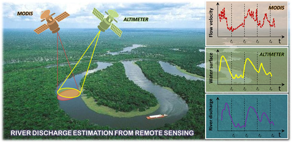
River discharge is defined as the amount of water flowing through a river over a specified period of time. Its estimate is crucial for all the operations of hydraulic structures design, the territorial planning and the flood risk assessment and management. River discharge at a specific river cross-section is not a direct measurement, but it is calculated by measuring other hydraulic quantities such as the flow velocity and the water depth, i.e. the water surface elevation with respect to the riverbed. Generally, these quantities are measured on site, but the increasing dismantling of gauged sites, caused by the high maintenance costs, and the scarce (sometimes total absence) presence of monitoring stations along the rivers in the developing countries, have generated the interest towards the use of an additional source of measurement represented by satellite sensors. Although not properly designed for this purpose, the sensors on satellite platforms are increasingly used for hydrological and hydraulic purposes with convincing results, especially at sites not adequately monitored. Specifically, the passive multispectral sensors (as the Moderate Resolution Imaging Spectroradiometer, MODIS) able to provide daily images in different bands of the electromagnetic spectrum, have demonstrated a high potential for estimating the river flow velocity. These sensors are able to identify the different behavior of the physical parameters between the water bodies and the surrounding land. This difference is used to evaluate the variations in the flow velocity in the rivers and tests over different water course in the world has confirmed its effectiveness.
Further information is obtained from radar altimeters, which allow to measure the water surface elevation of the river section. In this case, topographic surveys in situ (or alternatively specifically dedicated approaches) are required to estimate the river bottom in order to calculate the water depth. The remote measurements of these hydraulic quantities are used jointly to estimate the river discharge according to the traditional methods of the classical hydraulic. The use of satellite sensors therefore becomes fundamental not only to guarantee a temporal continuum in the river monitoring and to integrate the ground measurements, but also to provide an estimation of river discharge in developing countries, where a monitoring network often is totally missing.
Results
The procedure that uses satellite sensors, both passive and radar altimeters, to estimate the river discharge, was initially implemented along the Po River in northern Italy, where numerous gauged stations useful for the validation are located. Successively, it was also implemented along the Danube River, to test its validity even in larger river basins and with a higher river regime (the river discharge of the Danube is higher than those of the Po River). The results demonstrate that the procedure is able to provide reliable and accurate estimates of the river discharge in the two case studies. The procedure is currently being tested for the Sentinel-3 satellite mission, in which the two types of sensors are on the same satellite platform. Co-presence fosters spatial and temporal sampling of earth observations, since measurements are acquired at the same time and at the same location of the river. These preliminary tests, supports the next NASA SWOT mission, in which the on-board sensor has an improved technology for river monitoring, and it will be able to measure at global level rivers over 100 m wide.
Granting institutions
- International Water Management Institute, IWMI
- European Space Agency, ESA
To know more
Link to the project “RIDESAT” in IRPI website »
Tarpanelli A., Santi E., Tourian M.J., Filippucci P., Amarnath G., Brocca L. (2019). Daily river discharge estimates by merging satellite optical sensors and radar altimetry through artificial neural network. IEEE Transactions on Geoscience and Remote Sensing, 57(1), 329-341. doi:10.1109/TGRS.2018.2854625. https://doi.org/ 10.1109/TGRS.2018.2854625
Tarpanelli A., Amarnath G., Brocca L., Massari C., Moramarco T. (2017). Discharge estimation and forecasting by MODIS and altimetry data in Niger-Benue River, Remote Sensing of Environment, 195, 96-106. doi:10.1016/j.rse.2017.04.015. http://dx.doi.org/10.1016/j.rse.2017.04.015
Tarpanelli A., Brocca L., Barbetta S., Faruolo M., Lacava T., Moramarco T. (2014) Coupling MODIS and radar altimetry data for discharge estimation in poorly gauged river basin. IEEE Journal of Selected Topics in Applied Earth Observations and Remote Sensing, http://dx.doi.org/10.1109/JSTARS.2014.2320582.
Tarpanelli A., Brocca L., Barbetta S., Lacava T., Faruolo M., Moramarco T. Integration of MODIS and radar altimetry data for river discharge estimation from space. Proceedings of the IAEG 2014 Congress, Springer, 15-19 September 2014, Turin, Italy, 6 pp.
Tarpanelli A., Barbetta S., Brocca L., Lacava T., Faruolo M., Balint G., Di Baldassarre G. and Moramarco T. (2013). River Discharge Estimation By Using Remote Sensing Data: The Case Study Of The Danube River. Proceedings of Hydro 2013 International, 4-6 Dec 2013, IIT Madras, India.
http://www.egu.eu/awards-medals/union-osp-award/2014/angelica-tarpanelli/


 Contact person: angelica tarpanelli -