
Topographic thresholds for gully head formation in badlands. A new study published on “Earth Surface Processes and Landforms”

The article, titled “Topographic thresholds for gully head formation in badlands” has been recently published in the journal “Earth Surface Processes and Landforms”: The study was co-authored by Mauro Rossi & Dino Torri from Cnr Irpi and Jean Poesen, Sofie De Geeter & Cati Cremer from the Department of Earth and Environmental Sciences, KU Leuven, Heverlee, Belgium.
In synthesis
The study extends the gully topographic threshold model to badlands on the basis of data collected in the Mediterranean environment in Italy and Spain, characterized by diversified climatic, lithological, geological and anthropogenic settings. Criteria for the attribution of Curve Number values has been more objectively defined in order to reduce arbitrariness in threshold applications. Physical basics behind the gully head threshold concept have been revised requiring a description of the soil resistance in terms of frictional and cohesive components.
In detail
Gully erosion is a particularly damaging process which is not yet sufficiently understood and parameterized. Gully head topographic threshold relative to Hortonian runoff have been studied in cropland, rangeland and forest. This study extends such modelling approach to badlands. Different badlands (eight sites) have been studied in the Mediterranean environment in Italy and Spain, characterized by diversified climatic, lithological, and geological settings under different anthropogenic conditioning. Many badlands have been characterized by their specific human history in addition to their geomorphological properties. Land use, as part of the human history, strongly affected the formation many badlands and their development, through extremely impacting land exploitation (usually overgrazing). The effect of geological and geomorphological processes is usually particularly well visible. While the weakening effect of joints is confirmed, the different geological layer bedding orientation with respect to the slope aspect generates a different development of badland morphologies and different values of gully head thresholds values (as shown in two badlands sites on the same geological material and climate.
The selection of Curve Number values, at the base of the introduction of land use into the gully head thresholds, has been more objectively defined in order to reduce arbitrariness in threshold application. The study additionally revises some of the physical basics behind the gully head threshold concept, requiring a description of the soil resistance in terms of frictional and cohesive components. This implies the explicit inclusion of rock fragment into the grain size distribution, which cannot be limited to fine grains. It results into an enriched threshold formulation that allows to describe the condition for gully head initiation and retreat as the result of the trade-off between the frictional and cohesive components of the soil resistance forces. Eventually, the gully head threshold concept is confirmed and extended to include badlands.
Citation:
Rossi, M., Torri, D., De Geeter, S., Cremer, C. and Poesen, J., Topographic thresholds for gully head formation in badlands. Earth Surface Processes and Landforms. https://doi.org/10.1002/esp.5473
Web link: https://onlinelibrary.wiley.com/doi/10.1002/esp.5473
Additional references:
Rossi, M., Torri, D., Santi, E., 2015. Bias in topographic thresholds for gully heads. Nat Hazards 79, 51–69. https://doi.org/10.1007/s11069-015-1701-2
Torri, D., Poesen, J., 2014. A review of topographic threshold conditions for gully head development in different environments. Earth-Science Reviews 130, 73–85. https://doi.org/10.1016/j.earscirev.2013.12.006
Torri, D., Poesen, J., Rossi, M., Amici, V., Spennacchi, D., Cremer, C., 2018a. Gully head modelling: A Mediterranean badland case study: Gully head topographic threshold for badlands. Earth Surface Processes and Landforms 43, 2547–2561. https://doi.org/10.1002/esp.4414
Torri, D., Rossi, M., Brogi, F., Marignani, M., Bacaro, G., Santi, E., Tordoni, E., Amici, V., Maccherini, S., 2018b. Chapter 4 – Badlands and the Dynamics of Human History, Land Use, and Vegetation Through Centuries, in: Nadal-Romero, E., Martínez-Murillo, J.F., Kuhn, N.J. (Eds.), Badlands Dynamics in a Context of Global Change. Elsevier, pp. 111–153. https://doi.org/10.1016/B978-0-12-813054-4.00004-6
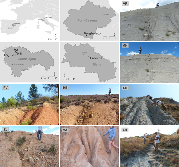
Location of study sites. Site codes in Italy: Verghereto VR, Montione MN; Leonina Biancana LH; Leonina Hillslope LB. Site codes in Spain: Puebla de Valles PV; Hiendelaencina HE; Villares de Jadraque VJ, Zarzuela de Jadraque ZJ.
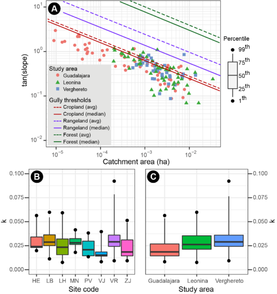
Soil surface slopes (tan slope) at the gully heads and their corresponding catchment areas (A) measured in the different badland study areas; solid and dashed coloured lines show respectively the median and average threshold trends determined for cropland (dark red), rangeland (purple), and forest (green) (Torri and Poesen. 2014). Variability of k values (equation 10) for the different badland study sites (B) and study areas (C).


