
Projects
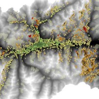
Integration of hydrometric measurements for river discharge monitoring and channel roughness coefficients assessment
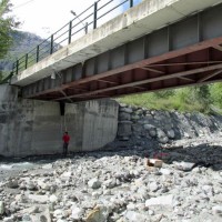
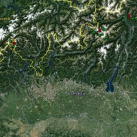
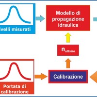 River discharge monitoring is fundamental for the study of the hydraulic regime of river flow and for the validation and calibration of rainfall-runoff models. The assessment of channel roughness coefficients associated with the measured discharges is fundamental for the calibration of flood routing models that can be used to address civil protection activities in real time. Unfortunately, the number of river flow monitoring stations in the ...
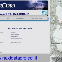
 Experimental Hydrological Database for Apennine Basins
 The main activities of the project, developed in the context of the program Nextdata funded by the Italian Ministry of Education, University and Research (MIUR), are:
collection, organization and analysis of the available hydro-meteorological and climate data for the characterization of the meteo-climate evolution in Apennine mountain areas;
extensive experimental campaigns for soil moisture monitoring in hillslope portions and ...
The main activities of the project, developed in the context of the program Nextdata funded by the Italian Ministry of Education, University and Research (MIUR), are:
collection, organization and analysis of the available hydro-meteorological and climate data for the characterization of the meteo-climate evolution in Apennine mountain areas;
extensive experimental campaigns for soil moisture monitoring in hillslope portions and ... EUMETSAT Satellite Application Facility on Support to Operational Hydrology and Water Management
 The H-SAF generates and archives high-quality data sets and products for operational hydrological applications starting from the acquisition and processing of data from Earth observation satellites in geostationary and polar orbits operated both by EUMETSAT and other satellite organization. The retrieval of products uses data from microwave and infrared instruments and aims at reaching the best possible accuracy compatible with satellite ...
 Hydrological and hydraulic studies to assess dam safety
 The artificial reservoirs are fundamental for water resources management, by regulating releases to meet the different users request (industrial, irrigation, hydropower, etc.), and for downstream territories floods defence through lamination of critical flood waves.
The main objective of the project concerns the review of hydrological-hydraulic studies carried out for the Montedoglio dam, on Tiber River, Casanuova dam, on Chiascio River, ...
The artificial reservoirs are fundamental for water resources management, by regulating releases to meet the different users request (industrial, irrigation, hydropower, etc.), and for downstream territories floods defence through lamination of critical flood waves.
The main objective of the project concerns the review of hydrological-hydraulic studies carried out for the Montedoglio dam, on Tiber River, Casanuova dam, on Chiascio River, ... Hydrological study of the Paglia river basin
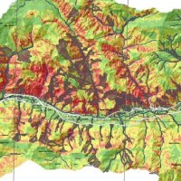
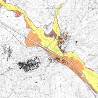 The Tiber River Basin Authority (ABT) and the Umbria Region (Service Water Resources and Hydraulic Risk), considering the verified underestimation of the flood-prone areas in the Paglia River basin provided by the Italian PAI (hydro-geological management plan) and the update of rating curves, decided to revise the hydrological study of the drainage basin in order to re-estimate the flood hazard maps for the Paglia River reach bounded upstream ...
 Modelling for real-time flood forecasting
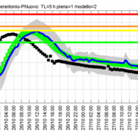 The project activities concern:
development and implementation of: 1) a semi-distributed continuous hydrological model (MISDc) for real-time soil moisture estimate and river discharge prediction in the Upper-Middle Tiber River basin; 2) a flood wave routing model (STAFOM-RCM) for stage hydrograph forecasting at some selected hydrometric stations in the Tiber River basin;
support for installation of soil moisture sensors in the ...
The project activities concern:
development and implementation of: 1) a semi-distributed continuous hydrological model (MISDc) for real-time soil moisture estimate and river discharge prediction in the Upper-Middle Tiber River basin; 2) a flood wave routing model (STAFOM-RCM) for stage hydrograph forecasting at some selected hydrometric stations in the Tiber River basin;
support for installation of soil moisture sensors in the ... ESA Climate Change Initiative Soil Moisture
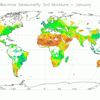 The CCI Programme wants to contribute to the data bases collecting ECVs required by GCOS (Global Climate Observing System) and other international parties. In particular, the Soil Moisture CCI will analyse the needs of the climate research community in terms of soil moisture data, adapt soil moisture satellite measurements for their use by the climate research community and create a long-term consistent soil moisture time series, based on ...
 Upper-middle Tiber river basin: the flood event of 25-28 november 2005
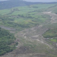
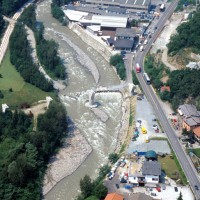
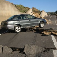
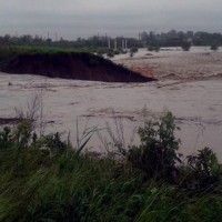
 On 25-27 November 2005, the territory of central Italy was affected by heavy rainfall that hit the Tiber River basin and, mainly, the province of Perugia. The meteoric event had a significant phase with a duration of approximately 48 hours with widespread precipitation up to a maximum accumulated value higher than 100 mm. Significant increases in water levels occurred in most rivers of Upper-Middle Tiber
causing extended flooding in ...
On 25-27 November 2005, the territory of central Italy was affected by heavy rainfall that hit the Tiber River basin and, mainly, the province of Perugia. The meteoric event had a significant phase with a duration of approximately 48 hours with widespread precipitation up to a maximum accumulated value higher than 100 mm. Significant increases in water levels occurred in most rivers of Upper-Middle Tiber
causing extended flooding in ... Investigation of the Montaguto Landslide
 In the spring of 2006, a large failure started moving in the Montaguto municipality, Campania, southern Italy, 40 km ENE of Benevento and 35 km SW of Foggia. The movement was a partial reactivation of an older mass movement in the same general area. In April 2010, the earthflow reached the Cervaro River valley, advancing at a maximum rate of approximately 5 ...
 Advanced Environment Monitoring System (SMAT) – F2
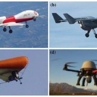 The environment monitoring has several purposes, including the prevention of geo-hydrogeological risks, forest fires, or prevention and suppression of illegal activities. The SMAT-F2 main objective is to define, design and develop an advanced monitoring system of the territory based on innovative unmanned air systems, coordinated by a supervision and coordination station (SSC). The first phase of the project, called SMAT-F1, finished at ...
 Monitoraggio del Rischio da Frane con tecnologie EO
 Le frane sono eventi del tutto naturali nell’evoluzione di un territorio, in particolare in Italia. Esse pongono un problema e diventano un pericolo allorché interagiscono con l’uomo e l’ambiente antropico. I movimenti franosi presentano una grande varietà fenomenologia. Le notevoli differenze nella tipologia, dimensione, e velocità di spostamento delle frane, rendono difficile e complessa la definizione della loro pericolosità, per ...
 Civil Protection Competence Centre on Geo-Hydrological Risk
 In Italy landslides and floods are frequent, widespread and dangerous phenomena, that cause fatalities and serious economic damage. In our country, landslides and floods pose major problems of scientific interest and of social and economic relevance.
The Institute is a Competence Centre for the Italian national Civil Protection Department, an Office of the Prime Minister. For the Department of Civil Protection we execute research and ...
In Italy landslides and floods are frequent, widespread and dangerous phenomena, that cause fatalities and serious economic damage. In our country, landslides and floods pose major problems of scientific interest and of social and economic relevance.
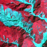
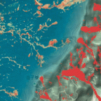
The Institute is a Competence Centre for the Italian national Civil Protection Department, an Office of the Prime Minister. For the Department of Civil Protection we execute research and ... Land cover change detection and monitoring methodologies based on the combined use of S1 and S2 for natural resources and hazard management
 ESA Sentinels missions will provide enhanced capabilities in the revisit frequency, and the coverage. Their complete exploitation is in the combination of the two to advantage of a further increased revisiting time and in the use of different wavelenght domains. This reflects in the capabilities to detect features of changes induced by different factors including natural hazards and crop ...
 H-SAF and GPM: precipitation algorithm development and validation activity
 The proposal intends to contribute towards the establishment of a long-term partnership between the EUMETSAT Satellite Application Facility on support to Operational Hydrology and Water Management (H-SAF, or Hydrology SAF) and the NASA/JAXA Global Precipitation Measurement (GPM) ...
 Innovative technologies at high environmental sustainability in the forest-based sector
 Millennium Ecosystems Assessment (ONU). Intergovernmental Convention on Climate and European Convention on the Protection of Forests. Integration of ground and remote technologies for Earth Observation and development of multi-resolution (spectral, spatial and temporal). Sustainable Forest Management (Ministerial Conference on the Protection of Forests in Europe). Decision support systems in the forest sector. Industrial technologies of the ...
 Spectral signatures library for semi-automatic event landslide recognition and mapping
 Earthquakes and strong rainfall precipitations, cause worldwide landslide. Inventories of the ground effects of an event must be prepared in a few days or less for the residual risk management. Satellite images and image analysis techniques have started to back up traditional mapping methods. Purpose of this project is to increase the automatization of image ...
 Connecting European Connectivity Research
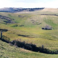
 Water and sediment connectivity has emerged in recent years as a significant conceptual framework for understanding the transfer of surface water and sediment through landscapes. Connectivity can be seen both as a driver of hydrological and geomorphic processes within a catchment and as an emergent catchment property that is the result of processes acting at different ...
 Investigations for the mitigation of geo-hydrological risk along the railway “Eccellente – Rosarno”
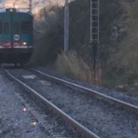 Large part of the territory is affected by geomorphological instability, often threatening the anthropic environment. Technical and socio-economic reasons often impose coexistence with the risks. Therefore, appropriate risk mitigation and/or reduction strategies must be implemented. Field and laboratory investigations, monitoring, modelling techniques and cartographic analyses are essential tools to acquire the necessary ...
 Space advanced project for excellence in research and enterprise
The project SAPERE is an Industrial Research oriented project (PON and FAR funds) focused on promoting the competitiveness of the National Aerospace Technology Cluster. The participants to the project include 8 private firms of the Cluster (industrial component), with Thales Alenia Space Italia being the leader, as well as academic (University) and research (CNR-National Research Council) ...
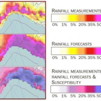
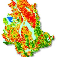
Rainfall thresholds for the possible initiation of rainfall-induced landslides in Apulia
 In Italy rainfall are among the main causes of trigger of shallow landslides, that yearly cause fatalities, damage, and severe economic losses. Identification of the amount of rainfall needed to trigger landslides, and the forecasting of rainfall-induced landslides, are of interest for the scientific community, as well as for the whole ...
 Instability problems related to man-made cavities in the Municipality of Ginosa
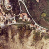
 The territory of Ginosa was severely affected by flood and instability problems in October and in December 2013, as many other municipalities at the boundary between Apulia and Basilicata. In particular, on October 7, 2013, four fatalities and serious damage had to be registered. Following these events, other instabilities have occurred, including the collapse of a stretch of Via Matrice, above artificial cavities, on January 21, ...
 RelationsHips between meteo-climAtic paraMeters and ground surface deforMation time sEries in mountain enviRonments
 There is a systematic lack of information on the effects of the climate and environmental changes on the frequency and the intensity of landslides and their triggering phenomena (Huggel et al., 2012). The problem is particular severe in mountain area, where natural and human-driven climatic and environmental changes may alter significantly the frequency and the intensity of the slope processes, with largely unknown short and long-term effects ...
 Ventennale dell’Alluvione in Piemonte del 1994
 Nel 2014 ricorrono vent’anni dalla tragica alluvione che nel novembre 1994 colpì gran parte del territorio piemontese, con perdita di vite umane, di beni mobili ed immobili. L’alluvione 1994 costituì altresì un momento storico nel campo della pianificazione territoriale, prevenzione e gestione della pericolosità e rischio geologico-idraulico, che si tradusse in dettami normativi, per l’epoca avanzati e lungimiranti. Da quell’evento ...
 Gestione dei Sedimenti Fluviali
 Il progetto GeSeFlu nasce dalla necessità della Regione Lombardia mediante il Piano Operativo Regionale (Direttiva Comunitaria 2000/60/CE) di disporre di specifici Programmi di Gestione dei sedimenti per i sottobacini redatti in attuazione della Direttiva del Comitato Istituzionale dell’Autorità di Bacino del fiume Po (deliberazione n. 9 del 5 aprile ...
 Analysis of instabilities in the historical centre of Mesagne
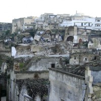
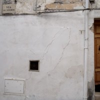 The instabilities that affected the historical part of Mesagne (Brindisi province, Apulia) since January 21, 2014, induced the local Authority to issue evacuation decrees for 18 families, corresponding to a total of 26 people. CNR IRPI was asked to provide scientific support for the identification of the processes at the origin of the ...
 Mobile Application for Emergency Response and Support
 The responsibilities within natural hazards involve citizens and volunteers as first actors of civil protection. The prevention implicates technical volunteers, but the priority implies now awareness of local citizens. The involvement of population creates context-specific strategies of territorial surveillance and management. MAppERS empowers “crowd-sourced mappers” through smart phone applications and sensors, with geo-tagged information, ...
 The 3 December 2013 Montescaglioso landslide
 On December 3, 2013, a large landslide activated on the SW slope of Montescaglioso (Matera province, Basilicata), affecting an area with evidence of past instability. The landslide involved some 500 m of the main road to the village, and also interested several houses and other ...
 SANF Liguria
 In Italy, landslides are triggered by intense and/or prolonged rainfall. The spatial and temporal forecast of multiple landslides triggered by rainfall in wide areas relies primarily on empirical rainfall thresholds. It is widely believed that the thresholds are influenced by the local topographic (morphological), lithological, soil, and climatic settings. For this reason, it is necessary to define local rainfall thresholds. Reliable local ...
 Cost of Natural Hazards in Italy
 Economic analysis has produced a set of analysis on natural disasters to measure the impacts of the events, the possibility of insurance schemes, and the optimization of prevention policies. In Italy these economic analysis are not widespread and the information on damage is limited. The available estimates are limited to the public money spent for post-event reconstruction and do not correspond to the total social ...
 Advanced and Integrated Monitoring of Earth DAMS
 The project AIM-DAMS is aimed at developing a laboratory of integrated and advanced environmental monitoring for the control of the behavior of the earth-dams due to the different factors acting on the dams during their lifetime. Based on the integration of innovative and non-invasive sensors, as well as recent monitoring techniques and numerical modelling, the project is intended to fulfill the need of the dam management agencies of using ...
 Analysis and monitoring of Planpincieux Glacier, Monte Bianco massif (AO)
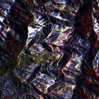
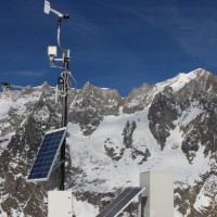 The Planpincieux Glacier is one of the glaciers that characterize the Italian side of the massif of the Grandes Jorasses. It is considered a temperate glacier and its front is currently located near a morphological step that determines a strong propensity to the activation of frequent ice falls in particular during the summer. These phenomena are typical of this glacier, but its particular asset may cause, as already occurred in the past, to ...
 Stability analysis in the Fantiano quarries
 The Fantiano quarries at Grottaglie (Taranto province) are an ancient sector of extraction of the local calcarenite rock, that is now used for concerts and shows. The instability phenomena observed in the quarries forced the Municipality of Grottaglie to ask to CNR-IRPI to perform stability analyses in the ...
 Spatial-temporal evolution of glacial resources in the Italian Alps over the last 100 years
 Glaciers are widely recognized as the best terrestrial indicator of climate change. Nevertheless, occurred changes, even in recent times, are often poorly known. Italy has a unique, secular history of glaciological documentation that, jointly with a rich wealth of spatial, multitemporal data, allows an accurate reconstruction of recent glacier evolution. Unfortunately, these data are dispersed and/or difficult to ...
 Landslide maps for the Castelfranci municipality
 Castelfranci (Avellino, Campania) is located in the catchment of the Calore River, in correspondence of a N-S oriented stretch of the river. This territory is intensely affected by landslide development, which more than once was in the past at the origin of severe damage to the local community, and heavy losses to ...
 Landslide Modelling and tools for vulnerability assessment Preparedness and REcovery management
 Il progetto FP7 LAMPRE - Landslide Modelling and tools for vulnerability assessment Preparedness and Recovery management svolge attività di ricerca innovative e di sviluppo tecnologico per migliorare le capacità del sistema Copernicus di far fronte a eventi di frana e alle loro conseguenze, in Europa e in altre parti del mondo. LAMPRE migliora il rischio di frana sforzi di mitigazione / preparazione e le attività di recupero e di ...
 SAR change detection methodologies for event landslide mapping
 The project explores and implements multi-scale and multi-sensor SAR change detection methodologies for event landslide mapping. Automated analysis for change detection is a challenging task due
to the inherent noisiness of SAR imagery and also to the high sensitivity to texture variability due to different acquisition angles. Moreover, pre-processing (de-speckling) may lead to the degradation
of the geometrical details and affect the ...
The project explores and implements multi-scale and multi-sensor SAR change detection methodologies for event landslide mapping. Automated analysis for change detection is a challenging task due
to the inherent noisiness of SAR imagery and also to the high sensitivity to texture variability due to different acquisition angles. Moreover, pre-processing (de-speckling) may lead to the degradation
of the geometrical details and affect the ... Alarm and monitoring systems for debris and mud flows
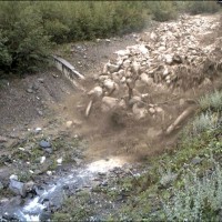
 Monitoring of debris flows in instrumented areas is carried out since many years in different Countries worldwide. It is still missing, however, an adequate standardization of methodologies, instrumentations and procedures. The instrumented areas are also employed for testing warning systems. Even though these latter have been more and more employed, a systematic experimentation of these systems has not yet been carried ...
 Increasing Resilience through Earth Observation
 To significantly contribute to the operational capacities in the context of Global Monitoring for Environment and Security (GMES)/ Copernicus by developing customised mapping and geo-information products addressing risk, vulnerability and assets ready for deployment in the prevention and preparedness phases – complementary to the GMES/Copernicus Emergency Management Service. Solutions to be provided are based for the most part on Earth ...
 RIVERbank Surveillance bAsed on Fiber optic sEnsors
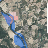
 In the last decades Europe and Italy suffered many damaging floods, causing thousands of deaths, the displacement of millions of people and billions of euros in insured economic losses. Veneto Region has been also strongly stricken in 2010. The European Commission has identified the need for adaptation of risk management in several documents in order to reduce the likelihood and/or the impact of floods [1]. Starting from these remarks, the main ...
 Analysis of the Mt. de La Saxe landslide
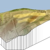
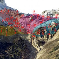
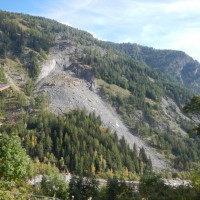 The Mont de La Saxe landslide affects the south-western side of Mont de La Saxe near Courmayeur, Valle d'Aosta. This landslide at present can be considered one of the most critical active landslides in the Italian Alps. The estimated unstable mass is more than eight millions of cubic meters and the main elements at risk are the hamlets of La Palud and Entreves, and the motorway access to the international tunnel of the Mont ...
 FLoods and fIre Risk assessment and managEment
 FLIRE is a demonstration project aiming to the development of an integrated Decision Support System (DSS) for both flash floods and forest fires risk assessment and management. The DSS tool will be designed by using state of art tools, technologies and methods and taking into account prevention, adaptation and interaction issues. The final model will be online available to key stakeholders and relevant authorities (local and national) for the ...
 Geo-hydrological hazards in the Pogliaschina catchment
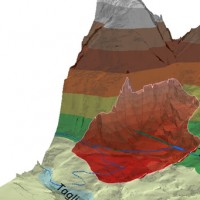
 The occurrence of flash floods in mountainous catchments is often associated to relevant geomorphic effects, both in the channel network (channel changes and transport of large wood), and on the hillslopes (landslides and soil erosion). The concomitance of flash floods, channel changes and landslides enhances hazards and risk associated to individual ...
 Climate change on slope failures initiation in the Italian Alps
 Climate change in the Greater Alpine Region is seriously affecting glacial and periglacial areas, with relevant consequences on slope stability. Cryosphere degradation, changes of the precipitation and temperature patterns and of the hydrological regimes, are some of the main terrestrial indicators of climatic change. Moreover, the increasing number of tourists and human activities rise the level of ...
 Sediment management in Alpine basins
 The understanding of the changing equilibrium between sediment supply from upstream and sediment transport capability of a river is important for the success of integrated water resource management. In Alpine river basins, intensive sediment transport processes and sediment continuity have a notable impact on several water management issues posing multiple use conflicts related to hydropower, ecology, flood control ...
 Monitoring system for the Hahnebaum test site
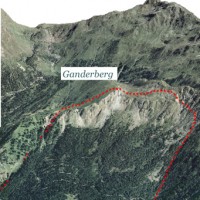 A Deep-seated Gravitational Slope Deformation (DGSD) affects the south-west flank of mount Ganderberg (Moso in Passiria – BZ). The continuous displacements of the landslide induce secondary hazardous phenomena. A 800.000 m3 rock slab shows signs of incipient movement; a detachment could create a natural barrier on the river ...
 Real-time monitoring of the “San Lorenzo” tunnel, Passo della Morte
 The entrance of the tunnel "San Lorenzo" in Forni di Sotto (UD) has built over a an active landslide body. The gravitational deformations of the slope are damaging the lining of the tunnel and creating a hazardous ...
 Spatially distributed modelling of landslide phenomena
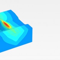
 The application of distributed physically based models is possible on relatively small areas, typically hundreds or few thousands of km2. Distributed modelling of slope dynamics requires many sufficiently detailed information. Knowledge of geotechnical parameters and land use, digital terrain models, medium/high resolution cartography, temporal evolution of soil moisture conditions, are ...
 Study and monitoring of the Rotolon landslide
 At the beginning of November 2010 exceptional rainfall events stroke the Veneto Region causing the re-activation of the Rotolon landslide which is a serious threat to the town of Recoaro Terme, Vicenza, ...
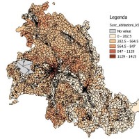
 Zonazione della suscettibilità da frana si scorrimento in Umbria
 Realizzazione di modelli e carte di suscettibilità da frana tipo scorrimento per il territorio della Regione ...
 Topographic monitoring of the Costa Concordia vessel wreck
 Following the run aground off near the "Isola del Giglio" (Tuscany, Italy, January 13, 2012) of the cruise vessel "Costa Concordia", a monitoring system for handling the security of the SAR (Search and Rescue) operations and for the control of the ships' movements/deformations during the subsequent defueling and recovery phases has been progressively installed and ...

