
Landslide Modelling and tools for vulnerability assessment Preparedness and REcovery management
Background
Il progetto FP7 LAMPRE – Landslide Modelling and tools for vulnerability assessment Preparedness and Recovery management svolge attività di ricerca innovative e di sviluppo tecnologico per migliorare le capacità del sistema Copernicus di far fronte a eventi di frana e alle loro conseguenze, in Europa e in altre parti del mondo. LAMPRE migliora il rischio di frana sforzi di mitigazione / preparazione e le attività di recupero e di ricostruzione post-evento – frana , in aree geografiche e geologiche altamente vulnerabili. Il progetto migliora la capacità di individuare e mappare frane, di valutare e prevedere l’impatto degli eventi di frana sugli elementi vulnerabili, e le modifiche del modello del paesaggio causati da errori di pendenza .
Purpose
The scope of LAMPRE is to enhance landslide risk mitigation & preparedness efforts and post-event-landslide recovery & reconstruction activities, in vulnerable geographic and geologic regions. LAMPRE improves the ability of stakeholders to:
- detect and map landslides,
- assess and forecast the impact of triggered landslide events on vulnerable elements, and
- model landscape changes caused by slope failures.
Methods
LAMPRE
- exploits innovative image processing techniques to improve the ability to detect and map landslides, exploiting HR and VHR satellite images,
- uses modern visualization tools to help detect and map landslides from VHR stereoscopic satellite images,
- uses new software to determine the statistics of landslide size (area, volume) and to determine landslide susceptibility using statistically-based methods,
- prepares 3D surface deformation models (3DSMs) combining advanced space-borne DInSAR products, in-situ monitoring data, and geological, geotechnical and groundwater information, and
- evaluates the potential vulnerability to event landslides through innovative Montecarlo simulations.
Results
LAMPRE has:
- experimented new methods and techniques for preparing and for updating existing landslide inventory maps (LIMs), exploiting very-high resolution (VHR) stereoscopic satellite images.
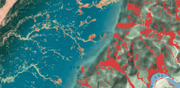
- prepared event landslide inventory maps (ELIMs) for different test sites ranging in areas from 25 to 80 square kilometres, including two ELIMs for the Kaopin area (Taiwan), an ELIM for the Pogliaschina area (Liguria, Italy) and an ELIM for the Giampilieri area (Sicily, Italy).
- prepared landslide susceptibility models and maps (LSMMs) for areas ranging from a few to several thousands square kilometres, including the Briga catchment (Messina, Italy), and the Umbria region (Italy).
- determined the statistics of landslide areas for a number of existing inventories, including a geomorphological inventory in Umbria and event inventories in Italy and Taiwan, and for a new inventory of sub-marine landslides offshore Israel.
- prepared 3D surface deformation models (3DSMs) for the El Portalet active landslide (Huesca, Spain) and the Ivancich active landslide (Assisi, Umbria, Italy).
Products
LAMPRE has developed the following products & services:
- Landslide inventory maps
- Event landslide inventory maps
- Software for landslide susceptibility modelling
- Software to determine the statistics of landslide sizes
- 3D Surface deformation models of slow-moving landslides
- Models for the vulnerability to landslides of infrastructures
- Educational materials
LAMPRE has published papers in international journals, including:
Mondini, A. C. and Chang, K.-T. (2014) Combining spectral and geoenvironmental information for probabilistic event landslide mapping, Geomorphology, 213(C), 183–189, doi:10.1016/j.geomorph.2014.01.007.
Mondini A.C., Viero A., Cavalli M., Marchi L., Herrera G., Guzzetti F. (2014) Comparison of event landslide inventories: the Pogliaschina catchment test case, Italy. Natural Hazards and Earth System Sciences, 14, 1749-1759, doi:10.5194/nhess-14-1749-2014,
Mondini A.C., Marchesini I., Rossi M., Chang K-T., Pasquariello G., Guzzetti F. (2013) Bayesian framework for mapping and classifying shallow landslides exploiting remote sensing and topographic data. Geomorphology, 201, 135-147, doi:10.1016/j.geomorph.2013.06.015.