RelationsHips between meteo-climAtic paraMeters and ground surface deforMation time sEries in mountain enviRonments
A project conducted in the larger NextData Italian project of national interest. (HAMMER)
Background
There is a systematic lack of information on the effects of the climate and environmental changes on the frequency and the intensity of landslides and their triggering phenomena (Huggel et al., 2012). The problem is particular severe in mountain area, where natural and human-driven climatic and environmental changes may alter significantly the frequency and the intensity of the slope processes, with largely unknown short and long-term effects on the landscape and the environment. HAMMER project intends to collect time series of ground deformation, and analyse eventual changes of the deformation trend/style associated with meteorological and climatic variables over time.
Reference: Huggel C., Clague J.J., Korup O., 2012 – Is climate change responsible for changing landslide activity in high mountains? Earth Surf. Process. Landforms, 37, 77-91.
Purpose
Main objectives of the project are:
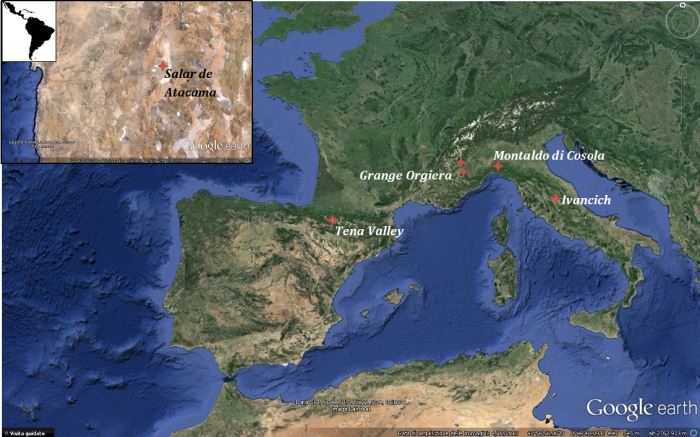
- Collect time series of surface and sub-surface ground deformations in landslide areas in the Alps, the Apennines, the Pyrenees and the Andes (Figure 1).
Figure 1. Test sites location.
- Collect time series of meteorological parameters for the same areas for which the ground deformations data will be collected.
- Demonstrate the capability of DInSAR techniques to provide multi-decadal time series of ground deformations in different physiographical and climatic environments.
- Attempt statistical correlations between time series of meteorological parameters and time series of the ground deformations, for selected test sites.
Methods
The analysis of surface movements aims to define the geomorphological evolution of single or multiple landslides. The short-term analysis of surface movements is obtained through quantitative or semi-quantitative analysis of three-dimensional topographic data and high accuracy measurements obtained exploiting different monitoring techniques (Giordan et al., 2013) In the HAMMER project, the analysis of surface movements are primarily carried by traditional in situ monitoring techniques (Total station; GPS receivers; Terrestrial LiDAR; Ground Bases Radar; extensometers; inclinometer), which provide ground deformation time series with very high temporal sampling, allowing for the reconstruction of the evolution of single landslide phenomena over time. The data has been obtained from previous internal studies of CNR-IRPI Torino, in particular of GMG group (http://gmg.irpi.cnr.it) and of CNR-IRPI Perugia (http://geomorphology.irpi.cnr.it/). Have been also used the relatively recent Differential SAR Interferometry techniques, which has significantly increased the information available on surface movements, especially in terms of spatial resolution, and are particularly suitable to monitor ground surface at the regional scale. In the framework of the HAMMER project, ERS-1/2 and ENVISAT ASAR earth observation missions of ESA supply a very large number of SAR images, generating a huge archive of information relevant to the period 1992-2010. The time series of ground deformation obtained allowing to following the evolution of surface displacement over time for the most part of the World, with a monthly temporal sampling.
Reference:
Calò F., Ardizzone F., Castaldo R., Lollino P., Guzetti F., Lanari R., Angeli M-G., Pontoni F., Manunta M., 2014 – Enhanced landslide investigations through advanced DInSAR techniques: the Ivancich case stuty, Assisi, Itlay. Remote Sensing of Environment, 142, 69-82.
Results
The main expected results of the project are:
- Analysis of the scientific and technical literature to determine where quantitative surface and sub-surface information on ground deformations in landslide areas is available, and for which periods.
- Combined time series of surface and/or subsurface ground deformations and of meteorological parameters.
- Critical analysis of the possibility of using space-borne DInSAR techniques to prepare multi-decadal time series of ground deformations for landslide areas, and their correlation with meteorological and climatic variables.
- Correlations of the time series available for selected test sites.
- Assessment of the feasibility and costs for a systematic extension of the activities conduced in HAMMER in Italy and in other mountain areas in the World.
Products
Le attività svolte nel primo anno di lavoro sono state:
- Gathering of deformation time series provided by in-situ measurements and meteorological data in two test sites located in the Alps: Gardiola Landslide and Grange Orgiera Landslide and 2 sites in Apennine environment: Montaldo Cosola Landslide and Ivancich Landslide.
- Gathering of meteorological/climate data recorded in meteorolgoical stations close to the study areas by using websites: http://www.regione.piemonte.it/ambiente/aria/rilev/ariaday/annali/meteorologici, e http://www.idrografico.regione.umbria.it/annali/default.aspx.
- metadata compiling according to NextData requests (http://geonetwork.evk2cnr.org). Metadata were compiled according to the INSPIRE rules (http://essi-lab.eu/do/view/GIcat/InspireMetadata).
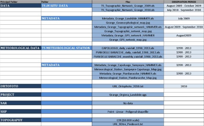
- Implementation of a FTP site dedicated to the maintenance of the data and to the internal data exchange (Table 1).
Table 1. FTP structure.
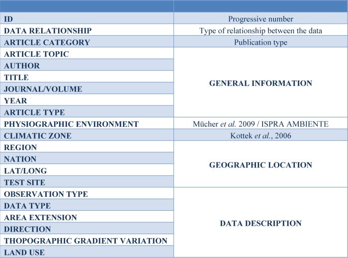
- Analysis of the scientific and technical literature to determine where quantitative surface and sub-surface information on ground deformations in landslide areas is available, and for which period has A database of scientific and technical papers been compiled. An excel file was produced and that lists about 100 records have been classified base on different criteria (Table 2). The file reports general information, such as authors, title, journal/volume, year, keywords and article type.
Table 2. LITERATURE REVIEW.
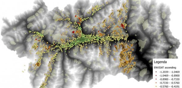
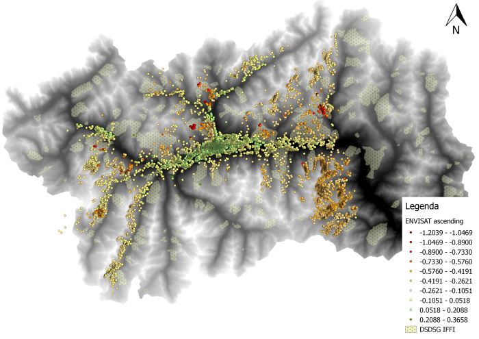
- Processing of SAR images (provided by ERS-1/2 and ENVISAT ASAR earth observation mission of ESA), relevant to the period 1992-2010. The ESA’s Grid Processing On Demand (G-POD, http://gpod.eo.esa.int/) was used. It is a service based on the recent Parallel-SBAS technique (Casu et al., 2014), to generate mean velocity maps, as well as deformation time series. The processing regarded the Valle d’Aosta Region (Figure 2).
Figure 2. VdA SBAS result.
Reference:
Casu F., Elefante S., Imperatore P., Zinno I., Manunta M., De Luca C. Lanari R. (2014) SBAS-DInSAR Parallel Processing for Deformation Time-Series Computation. IEEE JSTARS, doi: 10.1109/JSTARS.2014.2322671.
Kottek M., Grieser J., Beck C., Rudolf B. and Rubel F. (2006) – World Map of the Köppen-Geiger climate classification updated. Meteorologische Zeitshrift, Vol 15, No. 3, 259-261.
Mücher C.A., Klijn J.A., Wascher D.M. and Schaminée J.H.J. (2009) – A new European Landscaper Classification (LANMAP): A transparent, flexible and user-oriented methodology to distinguish landscapes. Ecological Indicators, 10, 87-103.
Conclusions
The HAMMER project was integrated into the NEXTDATA project from September 2016. The results of the work are described in the deliverables available at http://www.nextdataproject.it, while the metadata and collected data are available at http://geonetwork.nextdataproject.it/.



 Internal contact person: francesca ardizzone -