Analysis of the Mt. de La Saxe landslide
Analysis and Monitoring of the Mt. de La Saxe landslide, Courmayeur, Aosta Valley

Background
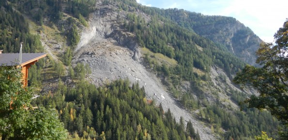
The Mont de La Saxe landslide affects the south-western side of Mont de La Saxe near Courmayeur, Valle d’Aosta. This landslide at present can be considered one of the most critical active landslides in the Italian Alps. The estimated unstable mass is more than eight millions of cubic meters and the main elements at risk are the hamlets of La Palud and Entreves, and the motorway access to the international tunnel of the Mont Blanc.
Purpose
Since 2009, a landslide-monitoring network has gradually been expanded and enhanced. In 2012, the CNR IRPI has been involved in the landslide management team to analyze the previous data and to define a kinematic model of the phenomenon. From 2013, the CNR IRPI started to support the Geological Survey of Valle d’Aosta for the management of the landslide-monitoring network and the early warning system.
Methods
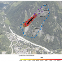
All the monitoring network dataset is managed using ADVICE (ADVanced Displacement Monitoring System for Early warning). This application is able to handle multi-instrument monitoring networks and to control any overcoming of predefined deformation thresholds. Using the application 3DA, we produced deformation maps and plots that are published on a dedicated web site page at the following link: http://gmg.irpi.cnr.it
Terrestrial and airborne LiDAR surveys were performed to support the study of the evolution of the landslide.
Results
CNR IRPI supported the Geological Survey of Valle d’Aosta region in the interpretation of the landslide and in the management of the most critical emergency phases. The disclosure system of monitoring data based on web platform and the emission of periodic bulletins allowed an easier and more effective access to the data by decision makers.
Products
The study and monitoring of the landslide allowed both the increasing of the degree of knowledge of the gravitational phenomenon and the development of a multi-level platform for the management and dissemination of multi-instrumental monitoring networks. The developed web based application is also able, in near real time, to manage a system of alert thresholds, and to publish a series of graphs and maps of deformation. Two distinct types of periodic bulletins with different levels of detail that correspond to a specific strategy for the dissemination of monitoring data were also developed and published.
Conclusions
The project included a phase of technical and scientific support to the Valle d’Aosta region for the understanding and management of the landslide and also the development of a strategy for the management and dissemination of landslide-monitoring dataset based on a web platform and periodical bulletins. The developed system was able to support decision makers during the emergency of 2014 and can be exported to other similar contexts.


 Internal contact person: -