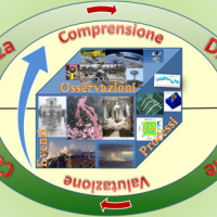
Il progetto prevede un’attività di servizio e di supporto tecnico scientifico per la realizzazione di progetti standard che affrontano i temi della pianificazione comunale di protezione civile e degli strumenti che possono rendere maggiore la sua efficacia. Il progetto propone uno schema che consente di definire, con metodologia rigorosa e omogenea, le attività da svolgere e il modo in cui svolgerle, per la realizzazione di un modello di ...
The Apulia region is affected by multiple types of geo-hydrological instability processes such as sinkholes, flash floods and landslides.
Landsliding mainly affects the north-western sector of the Region (bordering with Apennine chain) and the sea rocky cliffs.
The sub-Appennine Daunia portion of the Region is exposed to landslide risk due to hydro-geological setup of the soil/rock deposits, the poor mechanical properties of the ...
The project is focused on monitoring geohazard-associated ground deformations, a key prevention action specifically addressed to urban areas and critical infrastructures. The project will propose a procedure to produce maps to assess continuously the potential impact of geohazard activity. These maps will provide inputs to support early warning, giving information on the stability of the monitored areas and to evaluate the expected ...
The R&D project SMoRI starts from two needs to be reconciled. The first, coming from the scientific community, concerns a best definition of integrated monitoring systems aimed at controlling the conditions of high geo-hydrological risk. The second need is to acquire by the industrial partners a specialized know-how on new technologies related to Cloud Computing and I.o.T. and on the environmental ...
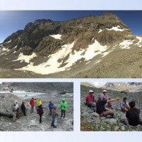
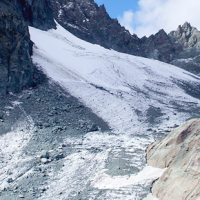
The researches at high-elevation sites continues, thanks to the RiST2 project (co-financed by Fondazione CRT of Torino). The study area is the Bessanese glacial basin. The Alpine environment and in particular the cryosphere, is responding quickly and with great intensity to climate change. The air temperature increase observed in the Alps urge the scientific communities involved in natural instability studies to consider not only air ...
The project focuses on climate predictions from seasonal-to-decadal timescales for the Mediterranean region (here defined as the domain encompassing the Mediterranean basin and the surrounding areas), and their applications in different sectors. The IRPI contribution will cover this aspect of the project, with specific reference to the conditions and evolution of cryosphere resources (WP4, Task ...
Climate change strongly impacts the whole European territory. Drought severely affects agriculture; precipitation extremes are associated with flooding, severe damage to properties and lives; temperature extremes can increase mortality; the seasonality and availability of snow affects water resources and winter tourism; wind speed or sunshine hours affect the production of renewable energy. These relations can be studied through the computation ...
Critical and depositional friction angles are characteristic for the deposition of a granular mass; the wrong angle adoption determines the ineffectiveness of a containment basin. The term is used with different meanings and measured by various procedures. The numerical simulation is a useful tool for the hazard assessment, but the definition of friction needed parameters requires insights on their ...
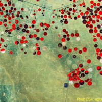
Irrigation is one of the greatest human intervention in the hydrological cycle. The knowledge of the distribution, the extent of irrigated areas and the amount of water used by irrigation is needed for different purposes: 1) modelling irrigation water requirements at the global scale, 2) assessing irrigated food production, 3) quantifying the impact of irrigation on climate, river discharge and groundwater depletion. Notwithstanding its ...
The improved understanding of the underlying physical processes of extreme events is closely linked to the development and verification of procedures to better control, analysis and validation of hydrological data for the description and visualization of meteorological events creating an operational "database of event" which enables to better identify under what conditions hazards ...
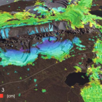
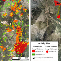
Space-borne radar interferometry or DInSAR (Differential Interferometric Synthetic Aperture Radar) is one of the latest techniques used for the detection and measurement of ground surface deformations caused by natural and / or man-made events. The DInSAR technique has been successfully used in the measurement of seismic deformations and of the effects of subsidence, unstable slopes and inflation of magma in volcanoes. The growth of space ...
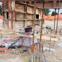
Application of optical fibers is generally aimed at large bandwidth transmission. Few people know that the proposal of optical fibers as sensing elements is almost as old as their proposal as transmission media, and over the last two decades fibre optic sensor (FOS) technology has assumed a dominant role in several fields of application. As a matter of fact, FOSs offer many advantages with respect to legacy electronic and mechanic sensors. ...
Environmental sensor monitoring is continuously developing, both in terms of quantity (i.e. measurement sites), and quality (i.e. technological innovation). Environmental monitoring is carried out by either public or private entities for their own specific purposes, such as scientific research, civil protection, support to industrial and agricultural activities, services for citizens, security, education and information.
The left Cenischia ...
The STRESS project is intended to design, implement and test a prototype of a Spatial Information Infrastructure (SII) enabling the provision to spatial planners and risk managers of new data and tools to improve hydro-geological susceptibility, hazard and impact assessment as well as to experiment alternative decision making ...
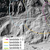
L’area del "Passo della Morte" (UD) è interessata da una situazione di grave dissesto a causa della presenza di più movimenti franosi. Questi sono caratterizzati da elevata pericolosità in relazione alle caratteristiche intrinseche dei fenomeni (volumetrie e velocità di spostamento), alla morfologia del versante ed alla geologia dell'area. La loro presenza mette a rischio la rete stradale che collega la Carnia con il Cadore e l’asta ...
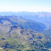
The Aosta Valley region presents a landscape almost totally occupied by mountain. In this context, a number of meaningful landslides is present, which vary from rock falls to deep-seated gravitational slope deformation (DsGSD), passing for the complex landslides. The study of these phenomena, finalized to guarantee suitable standard of safety and to facilitate a compatible development, results a fundamental necessity for this ...
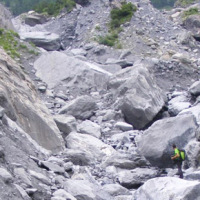
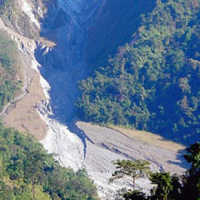
The study of the dynamics of large landslide is a heuristic process based on the integration of multiple investigation techniques: geological and geomorphological analysis, monitoring systems (traditional and innovative) and numerical models. Risk mitigation may require major interventions that call for detailed studies on the specific ...
The landslide monitoring represents a strategic activity, especially for those phenomena for which it is not possible (for technical or financial reasons) to realize stabilization interventions of the landslide. Nevertheless, the data acquisition is only the first part of the project, to which it is necessary to couple an on line management of the processed data and to realize monitoring ...
The research topics involve the consideration of geological, geomorphological, hydrological, hydrogeological, and technology and the use of innovative methodologies to achieve the sustainability of the natural balance inherent inland waters, with a focus on groundwater and river water. Finally, we consider the effects of climate change on the hydrological cycle and anthropogenic modifications to emphasize the contribution of these modifications ...
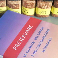
Producing knowledge implies the responsibility to divulge it with quality, making it available for everyone. With the advent of the Internet the possibilities to retransmit knowledge have grown, but the danger is also grown of a deterioration of its quality, as the Nobel prize Gell-mann already denounced in the nineties. The project intends to propose solutions to this kind of problem, contributing to improve the expressive capacity of thesis ...
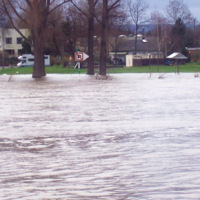
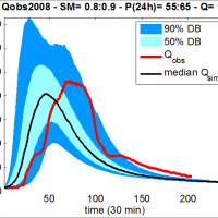
The project is focused on flood forecasting and hydraulic risk, i.e. the assessment of the effects of flooding in flood-prone areas also involving the vulnerability assessment of the hydraulic structures (dams, leaves, bridges, etc.).
The effects of flood events are not completely eliminated by structural measures, therefore it is necessary to develop complementary non-structural measures, such as real-time Flood Forecasting and Warning ...
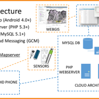
The management of natural hazards tends radically to distribute responsibilities at the local level, as the first civil protection actors. Prevention and preparedness are long-term goals, rooted in volunteer expertise, and awareness of local citizens, using solutions of "crowd-sourced mappers". The objective is designing mobile applications, sensors and dashboard for citizens and volunteers of civil protection, with pilot study cases selected ...
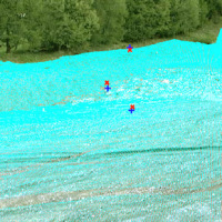
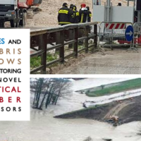
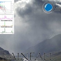
Usually the video cameras installed within a debris-flow monitoring site have the role of recording videos to better understand the behavior of the event for an improved interpretation of its dynamic. The use of such cameras for Image Velocimetry purpose is still nowadays a ...
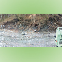
The aim of the geomorphometric analysis is to derive indices capable of characterizing the spatial variability of specific hydro-geomorphological processes (e.g., sediment connectivity, erosion and deposit). The growing availability of high-resolution topographic data has increased the interest in geomorphometry and its applications. Debris-flow monitoring in instrumented areas and flash-flood documentation are invaluable ways to gather field ...
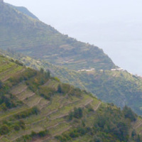
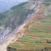
The project aims at defining the type of expected natural hazards, the modeling approaches relevant for their evaluation, and possible monitoring tools in specific areas prone to landslide risk within the "UNESCO site Portovenere, Cinque Terre and the Islands (Palmaria, Tino and Tinetto)" along the "Blue Trail" from Monterosso through ...
Both China and Italy are characterized by large mountainous areas, where natural hazards (e.g., geological and hydrological hazards such as debris flows, landsides, flash floods) are widespread and seriously threatening local society. It is noted that, almost 67% and 76% of the territories are covered by mountains in China and Italy, respectively and the youngest chains in the Eurasia, namely the Alps and the Tibetan Plateau, are characterized ...
In Italy, landslides are triggered by intense and/or prolonged rainfall. The spatial and temporal forecast of multiple landslides triggered by rainfall in wide areas relies primarily on empirical rainfall thresholds. It is widely believed that the thresholds are influenced by the local topographic (morphological), lithological, soil, and climatic settings. For this reason, it is necessary to define local rainfall thresholds. Reliable local ...
In India, as in many other areas in Asia and in the world, landslides are abundant and frequent, and they represent a serious hazard to the local population. The aim of LANDSLIP is to develop tools, including operational systems, to contribute to reducing impacts of hydrologically related landslide multi-hazards and to building resilience to landslides in vulnerable and hazard-prone areas of ...
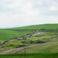
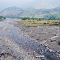
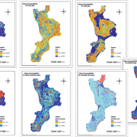
In international literature, it is now widely recognized that alluvial fans are areas of high geomorphic activity. Debris flows and flash floods occur episodically in these environments, and place many communities at high risk. Calabria (southern Italy) is a region where alluvial fans widely occur. In this region, the presence of mountain fronts/alluvial and/or coastal plain, or deep and narrow valleys debouching into larger valleys are key ...
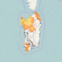
Calabria is part of the 27% of the Italian territory deemed at desertification risk from the Plan of the National Area with Puglia, Sicilia and Sardegna. This project had a realization in an area called Valle dell’Esaro, close to Crotone, that is an area with high desertification risk. In fact, this area for its soil, climate, morphology characteristics and for the agricultural procedures represents the best site to test a model of good ...
The Calabria region, because of its climatic, geomorphological and anthropic characteristics, is one of the regions most exposed to the risk of desertification in the Mediterranean basin. Methods already known in the literature and new approaches were applied at a basin scale on an area of the Ionian side, that, for rainfall and climatic characteristics, is one of the most exposed to this ...
EPSILON Italia, the leader of the partnership proposing the project, is a SME, located in Calabria, specializing in the delivery of advanced services for the protection and management of natural resources, with a high standard of quality and technological content. The SME is also actively involved in the development and implementation of new technologies and in R&D activities conducted both in their own and in partnership with universities ...
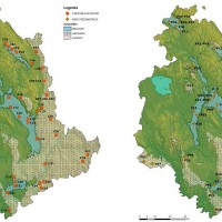
The purpose of Convention contracted between the Research Institute for Geo-Hydrologic Protection (Rende) and the Department of Physics of the University of Calabria for partnership in the Program CE INTERREG IIIB – ARCHIMED – SyNaRMa is to provide: i) the landslide-susceptibility maps for the different rock complexes of Calabria, ii) the definition of some important unstable slopes that can damage urban areas and main roads and railways of ...
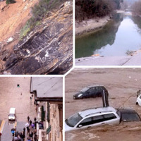
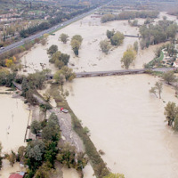
With more than 5 million people affected, more than 1000 killed, and with estimated total damages exceeding 4.5 billion Euros just in Europe and during the last decade, floods are among the most disruptive natural events threatening our Society. Due to increase in extreme weather events and rapid socio-economic developments in vulnerable locations, the risks connected to floods in general are growing rapidly, and the awareness of these risks ...
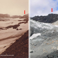
The Alpine environment, and in particular the high-altitude one, is responding quickly and with great intensity to climate change, through evidences of geomorphological, hydrological and ecological type. Mountain glacier shrinkage and related outcropping of rock walls and debris, changes of the precipitation and temperature patterns, are some of the main terrestrial indicators of climatic ...
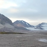
This project is embedded within the framework of the three Ny-Ålesund flagships: ‘Kongsfjorden system’, ‘Glaciology’ and ‘Terrestrial system’. The study of slopes and landscape modifications under a changing climate, is needed to understand the dynamic interaction between the cryosphere, hydrosphere, geosphere and biosphere, and how geosuccession and biosuccession (colonisation) processes develop over time. Records of landscape ...
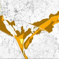
SAFETY aims at providing Civil Protection Authorities with the capability of periodically evaluating and assessing the potential impact of geohazards (volcanic activity, landslides and subsidence) on urban areas. The project improves the effort to detect and map geohazards, assess their activity and evaluate their impact on built-up areas and infrastructures ...
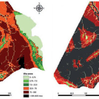
Some areas mapped in the Piani di Assetto Idrogeologico (Watershed Management Plan) of Piave, Brenta-Bacchiglione and Livenza Rivers require specific studies aimed at assigning a degree of hazard. Among the warning areas, there are numerous alluvial fans. The Soil Conservation Division of Veneto Region, in charge of the inquiry, identified the need to find an objective method for assessing the hazard of such ...
Italy has a tradition of scientific research and technological development on hazardous natural phenomena in general, and specifically on geo-hydrological hazards. Within the CNR, the “Progetti Finalizzati” Soil Conservation and Geodynamics (in the ’70s and ’80s), and GNDCI – the National Group for the Defence from Hydrogeological Disasters (in the ’80s and ’90s), have contributed to the advancement of knowledge ...
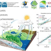
Monitoring the water cycle from satellite observations is one of the major goals of the EO community and closing the water budget has been a long-standing objective of international programs. After years of hard work, calibrating satellite data, improving inversion techniques, and facilitating the coherency of retrievals, it is admitted that the water cycle budget can now be ...
Quantitative information about precipitation is one vital input to meteorologists, hydrologic scientists, water resources managers, and environmental legislators. Yet, accurate measurement of precipitation over the relevant space and time scales remains a challenge. Soil moisture can be seen as the trace of the precipitation and, consequently, can be useful for providing a way to estimate rainfall accumulation or at least a new constrain to ...
State-of-the-art satellite rainfall products are often the only way for measuring rainfall in remote areas of the world. However, these products may fail in properly reproducing the amount of precipitation reaching the ground, which is needed for hydrological applications. The integration of satellite soil moisture products is expected to significantly improve rainfall ...
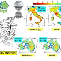
Recently, IRPI-CNR has developed an innovative approach for estimating rainfall from satellite soil moisture data, named SM2RAIN. The ESA funded project “Climate Change Initiative - Soil Moisture“ (CCI-SM) offers a valuable opportunity for testing SM2RAIN algorithm to a continuous, homogenous, long-term (>30 years) soil moisture time series. Indeed, SM2RAIN has the chance to be tested not only for rainfall estimation but also as a ...
The exploitation of innovative methods of SAR and optical data processing, combined to the use of ancillary data, is able to provide useful products for the landslide and seismic hazard ...
The project aims at using Soil Moisture Active and Passive (SMAP) soil moisture (SM) products at different spatial resolution (3, 9, and 36 km) for hydrological applications in Europe (mainly in ...
SECLI Project is aimed to assess the combined effects of processes related to natural and anthropogenic climate change on water resources, both surface and groundwater, in the Umbrian territory, identifying the possible consequences of such effects on drinking water policy, and on how these may affect the existing system of withdrawals and ...
The project activities were carried out in two phases:
"dynamic scenarios of flood risk" identification through hydrologic-hydraulic modeling addressed to Civil Protection activities (2009-2011);
operational implementation of developed dynamic scenarios of flood risk and results dissemination trough web-GIS technologies, also within the context of Floods Directive 2007/60 /EC (2012-203); flood forecasting models implementation; ...
The project activities were carried out in two phases:
delineation of flooding-prone areas for many river reaches selected in the secondary hydrographic network of Tiber River basin (2009-2011);
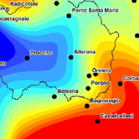
analysis of the severe flood event that affected the Paglia river basin on November ...
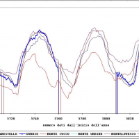
The activities of the project concerns the analysis and processing of hydro-meteorological data collected by the monitoring network of the Umbria Region for the period 1994-2014. In particular, the study regards the rainfall, temperature and water level time series. In addition, the discharge series corresponding to observed water levels are estimated for at hydrometric station through the rating curve estimated on the basis of flow velocity ...
The activities of the project concern the delineation of hazard maps for return periods of 50, 100, 200 and 500 years for many reaches of interest identified in the secondary hydrographic network of Tiber ...


