
Database of landslides in Calabria to be uploaded in the SyNaRMa computerized archives
Scientific agreement between the Research Institute for Geo-Hydrologic Protection (Rende) of National Research Council and the Department of Physics of the University of Calabria for partnership in the Program CE INTERREG IIIB – ARCHIMED – SyNaRMa Project “Development of an Information System for Natural Risk Management in the Mediterranean” (SyNaRMa)
Background
The purpose of Convention contracted between the Research Institute for Geo-Hydrologic Protection (Rende) and the Department of Physics of the University of Calabria for partnership in the Program CE INTERREG IIIB – ARCHIMED – SyNaRMa is to provide: i) the landslide-susceptibility maps for the different rock complexes of Calabria, ii) the definition of some important unstable slopes that can damage urban areas and main roads and railways of the region.
Purpose
The scientific activity carried out by the Institute for the “SyNaRMa” Project has regarded:
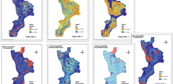
- the production of a mass movement susceptibility maps for the different rock complexes of Calabria at 1:250.000 scale;
- a detailed study of mass movement susceptibility in five sample zones of Calabria (1:10.000 scale);
- the implementation of a database which lists information on landslides that involved urban areas and main roads and railways of Calabria.
Methods
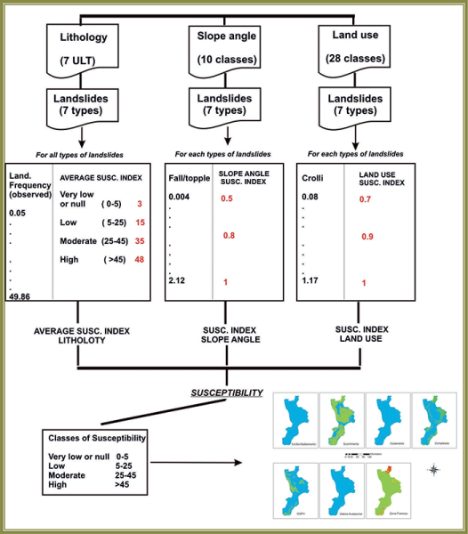
For the development of the first and second step of the project, it was adopted an expert-evaluation based procedure with the help of GIS techniques for obtaining a DEM-derivate variable (slope gradient), and to process data in a rapid and reliable way (package Arc-Gis9). Expert-evaluation is actually based on experience and deep knowledge of the Calabria territory gained by Authors in previous studies. In particular, in these studies, it is confirmed that the territorial frequency of mass movement is strictly associated, in the following order of importance, by lithology, slope angle, and land use. It was carried out an evaluation of mass movement susceptibility for each relevant type of mass-movement, using the observed frequency of each type of mass movement according to the lithology, and then weighting the average using the other two variables. The weigh for the other two variables – slope angle and land use – has been assigned based on expert evaluation. The third step of activity has regarded the implementation of a database. For each urban area of Calabria, it is possible to have information about the landslides that involve the slope as type, area, activity state, etc. As regards the main roads and railways, it is possible to have information about the segments of infrastructures involved by landslides.
Products
Maps of territorial distribution of susceptibility for each relevant type of mass-movement for the whole Calabria territory (1:250.000 scale) and for five sample areas (1:10.000 scale); data base.
 Internal contact person: loredana antronico -