
SLOPES
Late-glacial and present landscape evolution following deglaciation in a climate-sensitive High Arctic region
Background
This project is embedded within the framework of the three Ny-Ålesund flagships: ‘Kongsfjorden system’, ‘Glaciology’ and ‘Terrestrial system’. The study of slopes and landscape modifications under a changing climate, is needed to understand the dynamic interaction between the cryosphere, hydrosphere, geosphere and biosphere, and how geosuccession and biosuccession (colonisation) processes develop over time. Records of landscape change constitute one important element to our understanding of past and present environmental conditions, and constitute a key element to these three flagships.
Purpose
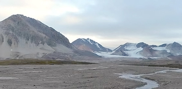
The project will quantify slope landscape evolution during the Holocene following climate change, focusing on the effects of Late-glacial to Holocene versus Little Ice Age to present deglaciation at selected sites along the Kongsfjorden area (NW Spitsbergen, Svalbard Archipelago). The main aim is to test the conceptual model for paraglacial adjustment in permafrost region focusing on timescales of rock slope evolotuion, development of rock glaciers, and the stability of ice-cored moraines. The results will provide a contribution to the contested question of long-term periglacial landscape evolution.
Methods
- Overview mapping of slope systems of the Kongsfjorden area from aerial photographs and field investigations. Fieldwork and sample collecting will be carried out according to current regulations and requirements for Svalbard, Ny-Ålesund and protected areas.
- Field analysis of selected slopes (i.e. detailed geomorphological mapping of surface-cover deposits and active processes), and glacial, periglacial, slope and fluvial landforms; geomechanical analysis; geomorphometric and geophysical investigations of sediment source (terrestrial laser scanner, GPS, ERT and GPR geophysical investigation), and related drainage systems.
- Remote sensing analysis of the selected slopes, interferometric analysis of SAR imagery, rock fall and debris 2D-3D numerical modelling.