
Methodology for the estimation of environmental risk indicators, using satellite remote sensing techniques
(MIRASAT)
Background
EPSILON Italia, the leader of the partnership proposing the project, is a SME, located in Calabria, specializing in the delivery of advanced services for the protection and management of natural resources, with a high standard of quality and technological content. The SME is also actively involved in the development and implementation of new technologies and in R&D activities conducted both in their own and in partnership with universities and research centers. Within the MIRASAT Project, EPSILON Italia has launched a partnership with the Department of Soil Protection of the University of Calabria and the CNR-IRPI of Cosenza, with the intent to further specialize in satellite remote sensing, using the know-how in areas related to environmental risk management.
Purpose
The main goal of the “MIRASAT” project was to develop a methodology based on the processing of remote sensing data from satellite, for the identification and the estimation of environmental risk indicators, with particular attention to the risks related to geo-hydrological phenomena and to soil degradation, caused by both natural and anthropogenic factors. By means of the project it was possible: a) to acquire knowledge for the development of a service sector in the use of innovative technologies for environmental protection and territory management/development; b) to improve the strategic positioning of the enterprise, leader of the partnership, within the regional and national market of high-tech services; c) to increase the technological know-how of the enterprise; d) to qualify the human resources employed in the project.
Methods
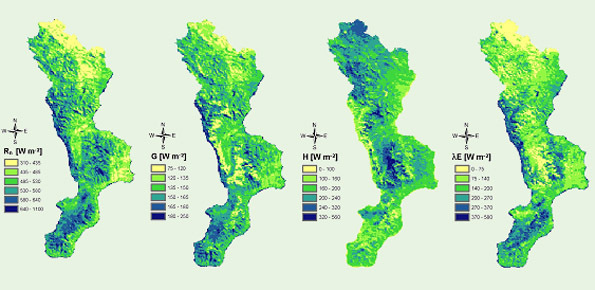
During the project it has been made an extensive use of vegetation indices and of their various combinations. In particular, the VI (Vegetation Idex) and its derivatives (NDVI – Normalised Difference Index – and TVI – Transformed Vegetation Idex), being easily correlated to the biomass content, represent good indexes of the crop vigor. In addition, the index LAI (Leaf Area Index), together with the mentioned vegetation indices, can also be correlated to the deficiencies of water and of plant nitrogen.
Results
The results can be summarized as: a) identification of the geo-bio-physical variables related to soil degradation, estimated from satellite data; b) identification of soil degradation indicators that, starting from environmental variables estimated by remote sensing data, allow the identification of sensitive areas to degradation phenomena; c) definition of the specifications of the satellite data processing phases; d) data processing in order to estimate the most sensitive areas to degradation processes; e) validation and calibration methods through in situ measurement campaigns.
Products
The products are several technical and scientific reports with the major results of the various project phases. The results were also presented by the project partners in Workshops, Conferences and Meetings.
Conclusions
The results achieved in the “MIRASAT” project can be considered an excellent base for the creation of geographic databases and thematic information on the environmental risk. These may be usable in web-based GIS applications and advanced data analysis systems, which also provide simulations of possible time evolutions of the phenomena. In addition, the project has enabled the EPSILON Italia to improve its strategic positioning in the context of the high-tech services market (regional, national and international).
 Internal contact person: roberto coscarelli -