Spatially distributed modelling of landslide phenomena
Background
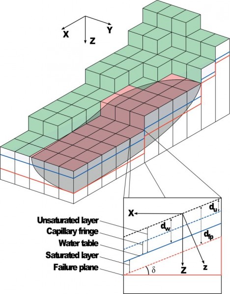
The application of distributed physically based models is possible on relatively small areas, typically hundreds or few thousands of km2. Distributed modelling of slope dynamics requires many sufficiently detailed information. Knowledge of geotechnical parameters and land use, digital terrain models, medium/high resolution cartography, temporal evolution of soil moisture conditions, are mandatory.
Purpose
The goal of the project is the development of a number of software tools aimed at modeling slope stability at the regional scale. Such a development involves both existing software and original ones, or innovative ways of using existing models. This effort is aimed to apply the models to real settings and also to actively contribute to the activities of the scientific community.
Methods
The activities involve two main aspects. First, the uncertainty related to geotechnical, environmental and geometrical parameters is handled with statistical methods, based on field data. Second, advanced (parallel) computing techniques are used to develop scalable algorithms on high performance hardware, to allow improved accuracy and deal with increasingly large areas.
Results
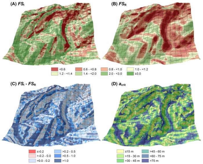
The project is ongoing. Existing results are: possibility of using probabilistic inputs and completely parallel implementation of the well knows computer code TRIGRS; development of a new code for the assessment of slope stability against rotational landslides; development of a model for the assessment of the effects of land use change on soil erodibility and stability; development of a model for the definition mapping units (Slope Units) for the statistical modelling of landslide susceptibility.
Products
Alvioli, M. and Baum, R. L. (2016). “Parallelization of the TRIGRS model for rainfall-induced landslides using the message passing interface” Environ. Model. Soft. 81, 122-135. doi:10.1016/j.envsoft.2016.04.002
Alvioli, F. Guzzetti, M. Rossi “Scaling Properties Of Rainfall-Induced Landslides Predicted by a Physically Based Model”;
Geomorphology 213 (2014) 38-47. doi:10.1016/j.geomorph.2013.12.039
Raia, M. Alvioli, M. Rossi, R.L. Baum, J.W. Godt, F. Guzzetti
“Improving Predictive Power Of Physically Based Rainfall-Induced Shallow Landslide Models: A Probabilistic Approach”;
Geoscientific Model Dev. 7 (2014) 495-514. doi:10.5194/gmd-7-495-2014
Mergili, I. Marchesini, M. Rossi, F. Guzzetti, W. Fellin., “Spatially distributed threedimensional slope stability modelling in a raster GIS”. Geomorphology, 206 (1) (2014), pp. 178–195. doi:10.1016/j.geomorph.2013.10.008
M. Mergili, I. Marchesini, M. Alvioli, M. Metz, B. Schneider-Muntau, M. Rossi, F. Guzzetti “A Strategy For GIS-Based 3-D Slope Stability Modelling Over Large Aareas”;
Geosci. Model Dev. Discuss., 7, 5407-5445, 2014. doi:10.5194/gmdd-7-5407-2014
Mergili, M., Marchesini, I., Alvioli, M., Rossi, M., Santangelo, M., Cardinali, M., … & Guzzetti, F. (2015). GIS-Based Deterministic Analysis of Deep-Seated Slope Stability in a Complex Geological Setting. In Engineering Geology for Society and Territory-Volume 2 (pp. 1437-1440). Springer International Publishing. doi:10.1007/978-3-319-09057-3_254
Rossi, M., Torri, D., Santi, E., Bacaro, G., Marchesini, I., Mondini, A. C., & Felicioni, G. (2015). Slope Dynamics and Climatic Change Through Indirect Interactions. In Engineering Geology for Society and Territory-Volume 1 (pp. 551-555). Springer International Publishing. doi:10.1007/978-3-319-09300-0_103
Marchesini, I., Mergili, M., Rossi, M., Santangelo, M., Cardinali, M., Ardizzone, F., … & Guzzetti, F. (2014). A GIS Approach to Analysis of Deep-Seated Slope Stability in Complex Geology. In Landslide Science for a Safer Geoenvironment(pp. 483-489). Springer International Publishing. doi:10.1007/978-3-319-05050-8_75
Rossi, M., Torri, D., Santi, E., Bacaro, G., & Marchesini, I. (2013). BIO_SOS Modelling Activities: Modelling Runoff-Sediment Connectivity. Proceedings of the GI_Forum 2013 – Creating the GISociety. 2013, 566 pages Print edition is available at Wichmann-Verlag, Berlin. doi:10.1553/giscience2013
–http://www.slopestability.org
Conclusions
The project is ongoing and a few goals have been met. The most relevant ones are the inclusion of probabilistic Monte-Carlo techniques to deal with of input data and the generalization of the codes, which are now suitable to be run on multi-processor machines and PC clusters, with a sensible gain in term of computing time and increased allowance for study area sizes. One of the next goals is the implementation of a few of the models in “real-time” mode, which is the repeated execution at given time intervals, taking into account the hourly variations of soil moisture conditions.