The Copernicus Sentinel-3 Surface Topography Mission (STM) provides extremely valuable surface elevation information over inland waters, sea ice and land ice, thanks to its SAR altimeter which retrieves high-resolution along-track elevation measurements, and to its orbit that covers high-latitude polar regions.
To ensure that these measurements can be used with confidence, and to maximize the return on investment of the Copernicus Sentinel-3 ...
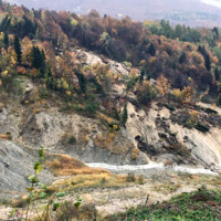
The Aosta Valley is a small alpine region affected by numerous landslides, varying in size and type, ranging from isolated rock falls to rotational/translational slides up to extensive deep landslides. The study of such landslides, functional to a more effective risk management and to guarantee adequate safety standards, represents a primary necessity for a mountain territory like this ...
Geological-geotechnical monitoring systems are one of the most effective tools for landslide characterization, both in terms of landslide detection and for monitoring purposes. The regional monitoring network of Regione Lombardia represents an exemplary case in Italy, with as many as 44 landslides monitored, of which more than half in real time.
The management of monitoring networks and early warning systems represents a complex component, in ...
Climate change has a powerful impact on high-altitude Alpine sectors and glaciers. This impact often turns into an increase in instability processes that can lead to very high-risk conditions. These risk conditions can significantly affect the usability of areas characterized by intense tourist flows, making risk management very ...
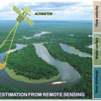
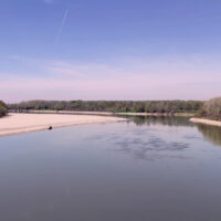
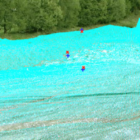
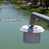
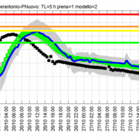
River discharge is defined as the amount of water flowing through a river over a specified period of time. Its estimate is crucial for all the operations of hydraulic structures design, the territorial planning and the flood risk assessment and management. River discharge at a specific river cross-section is not a direct measurement, but it is calculated by measuring other hydraulic quantities such as the flow velocity and the water depth, i.e. ...
When soil behaviour is studied, whether landslide soils are concern, levee materials or foundations, the problem regarding how much and how reliable information about the soil properties we have available has to be addressed.
Understanding “what’s beneath” the visible surface is fundamental, yet complicated. Drillings are performed to analyse the stratigraphy of soils (the order and the thickness of the different soil levels) and ...
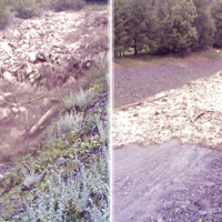
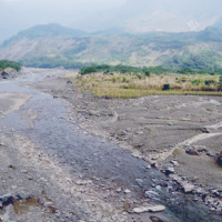
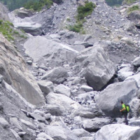
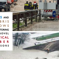
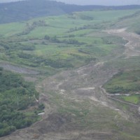
Not all that flows in creeks is water. Debris flows i.e., surges in which solid particles move together with little water, may occur in steep mountain streams, mainly as a consequence of intense rainfall. Debris flows have a high kinetic energy, and may cause major damage if they encroach buildings, roads and bridges. They are also a primary cause of landslide casualties. The video below shows an example of debris flows.
The low ...
Landslides and earthquakes are important geological hazards in Italy, where mountains and hills dominate a landscape characterized by the presence of weak geological materials. The geological and morphological settings result in high susceptibility to landslides under seismic conditions. Italy is also one of the most active tectonic regions in Europe; and seismic shaking is known to have caused landslides in Italy.
Numerous historical ...
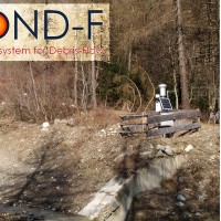
ALMOND-F is an innovative unit for the microseismic detection of debris flows using a network of geophones.
The microseismic detection of debris flows is more complex than other types of monitoring. Use of the geophones requires: (1) the selection of the level of amplification of the signal, which depends on the distance from the stream; (2) the selection of the sampling frequency of the seismic signal, which must be sufficiently high; (3) ...
The development of an innovative system for monitoring river flows during extreme events and the impact of hydrodynamic pressures on ecosystems are two important challenges identified by the World Meteorological Organization for flood event control and by the European Commission for the European Biodiversity Strategy for the protection of ecosystems and ...
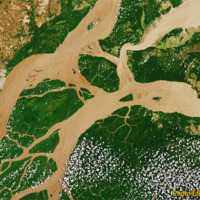
Although representing less than 1% of the total amount of water on Earth, the freshwater is essential for terrestrial life and human needs. Despite the existing in-situ gauging networks represent a tool for quantifying the instantaneous water volume in many river channels, we have surprisingly poor knowledge of the spatial and temporal dynamics of surface river discharge. Developing new procedures for river discharge estimation based on ...
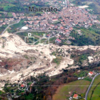
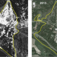
The Maierato landslide (Vibo Valentia Province) is a complex movement, which involved a significant thickness of geomaterials (rocks and soils) and rapidly flowed away for one kilometre. Owing that, the surrounding zone is interested by the same geological settings that predisposed the Maierato landslide, it is useful to identify any elements indicative of the presence of instabilities that can be triggered and evolved as the Maierato ...
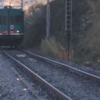
In recent years, following short and intense meteoric events, along the railway line of the Department of Reggio Calabria, there have been a series of interruptions in correspondence of basins below 3-4 km2. Based on the current procedures for risk mitigation in RFI, in the event of a "red alert" issued by the Civil Protection, RFI management locate along the railway line personal in correspondence of the area in question. This procedure is ...
L'IRPI è da molti anni impegnato nel monitoraggio di variabili idrologiche (umidità del suolo, pioggia, portata e velocità dei corsi d'acqua) che è risultato fondamentale per la rappresentazione del processo di formazione del deflusso e quindi per lo studio delle piene e delle ...
The IRPI Aerialphotografical archive consists of about 170000 aerial photographs of Northern Italy (1954-2005) useful for a stereoscopic vision. It also includes military flights (Royal Air Force) carried out during the Second World War. For some areas there are also rare aerial shots of the years 20, 30 and 40, often in diachronic form (5-10 years). The documentation refers to geo-hydrological events occurring on large areas and characterized ...
The knowledge of the geo-hydrological hazard of a territory and of the risk conditions for people, are essential for the implementation of civil protection activities. The monitoring activity by personnel, voluntary or not, is a strategic resource for all phases of civil ...
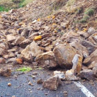
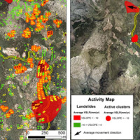
Among all types of landslide phenomena present in Alpine environment, the rockfalls are certainly the most impacting, because they also are extremely widespread. Rockfall are very difficult to monitor and they are often managed exclusively through the execution of active or passive works aimed at risk mitigation. Due to the rockfalls impulsive behavior, it is a difficult task to locate them a priori. The problem of rockfalls can be approached ...
The development of new systems for monitoring of landslides is often the synthesis of geomatics and applied geology. In particular, the development of innovative low-cost systems must have a strong geomatics and technological component supported by the definition of required elements done by end users (engineering geologists). The development of low-cost monitoring systems can represent a strategic choice, above all, to guarantee an increasing ...
The Tessina Landslide has been, almost continuously, monitored by IRPI, Padova Unit, since its main reactivation in April 1992. Therefore the Veneto Region entrusted IRPI with the continuation of such activity to be extended to the Lamosano landslide too, in order to identify the most effective countermeasure to mitigate the induced ...
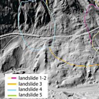
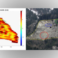
The Municipality of Ne (GE) is involved by an important landslide in the Arzeno and Prato di Reppia areas. The phenomenon is monitored using standard techniques for some years. The goals of this study is increasing the knowledge of the phenomenon using automatic monitoring ...
The company "Progetto Gestione Bacino Bari Cinque srl" has entrusted at the Research Institute for Geo-Hydrological Protection of the CNR the “Hydrogeological study for the risk analysis of the site where the plant of the treatment and disposal of solid urban waste of the same company is located in Contrada Martucci, municipality of Conversano ...
The project concerns the mitigation of natural hazards (mainly the effects on the territory and the anthropic environment caused by rains, earthquakes, volcanism, and Radon gas). The geological characterization is essential to frame the contexts and the expected phenomena. Numerical modeling and monitoring allow to predict the spatio-temporal evolution of the phenomena, and therefore to evaluate the risk for mitigation ...
The project is focused on monitoring geohazard-associated ground deformations, a key prevention action specifically addressed to urban areas and critical infrastructures. The project will propose a procedure to produce maps to assess continuously the potential impact of geohazard activity. These maps will provide inputs to support early warning, giving information on the stability of the monitored areas and to evaluate the expected ...
The R&D project SMoRI starts from two needs to be reconciled. The first, coming from the scientific community, concerns a best definition of integrated monitoring systems aimed at controlling the conditions of high geo-hydrological risk. The second need is to acquire by the industrial partners a specialized know-how on new technologies related to Cloud Computing and I.o.T. and on the environmental ...
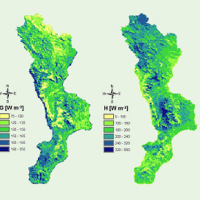
Climate change strongly impacts the whole European territory. Drought severely affects agriculture; precipitation extremes are associated with flooding, severe damage to properties and lives; temperature extremes can increase mortality; the seasonality and availability of snow affects water resources and winter tourism; wind speed or sunshine hours affect the production of renewable energy. These relations can be studied through the computation ...
The improved understanding of the underlying physical processes of extreme events is closely linked to the development and verification of procedures to better control, analysis and validation of hydrological data for the description and visualization of meteorological events creating an operational "database of event" which enables to better identify under what conditions hazards ...
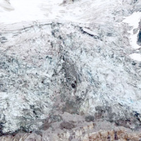
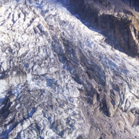
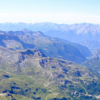
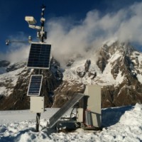
Glaciers are typical of the Alpine landscape, and an important source of water. Undoubtedly fascinating, glaciers are very complex and yet surprisingly poorly known. In the Alps, many studies focus on the volumetric changes of glaciers, proving their almost systematic reduction in the current climatic period. Little is known about the daily behaviour of Alpine glaciers. This is partly due to the inhospitable and not easily accessible ...
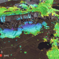
Space-borne radar interferometry or DInSAR (Differential Interferometric Synthetic Aperture Radar) is one of the latest techniques used for the detection and measurement of ground surface deformations caused by natural and / or man-made events. The DInSAR technique has been successfully used in the measurement of seismic deformations and of the effects of subsidence, unstable slopes and inflation of magma in volcanoes. The growth of space ...
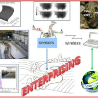
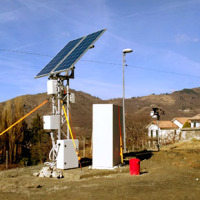
Environmental sensor monitoring is continuously developing, both in terms of quantity (i.e. measurement sites), and quality (i.e. technological innovation). Environmental monitoring is carried out by either public or private entities for their own specific purposes, such as scientific research, civil protection, support to industrial and agricultural activities, services for citizens, security, education and information.
The left Cenischia ...
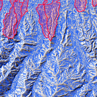
L’area del "Passo della Morte" (UD) è interessata da una situazione di grave dissesto a causa della presenza di più movimenti franosi. Questi sono caratterizzati da elevata pericolosità in relazione alle caratteristiche intrinseche dei fenomeni (volumetrie e velocità di spostamento), alla morfologia del versante ed alla geologia dell'area. La loro presenza mette a rischio la rete stradale che collega la Carnia con il Cadore e l’asta ...
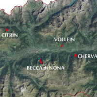
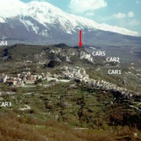
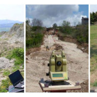
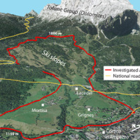
The Aosta Valley region presents a landscape almost totally occupied by mountain. In this context, a number of meaningful landslides is present, which vary from rock falls to deep-seated gravitational slope deformation (DsGSD), passing for the complex landslides. The study of these phenomena, finalized to guarantee suitable standard of safety and to facilitate a compatible development, results a fundamental necessity for this ...
The study of the dynamics of large landslide is a heuristic process based on the integration of multiple investigation techniques: geological and geomorphological analysis, monitoring systems (traditional and innovative) and numerical models. Risk mitigation may require major interventions that call for detailed studies on the specific ...
The landslide monitoring represents a strategic activity, especially for those phenomena for which it is not possible (for technical or financial reasons) to realize stabilization interventions of the landslide. Nevertheless, the data acquisition is only the first part of the project, to which it is necessary to couple an on line management of the processed data and to realize monitoring ...
Usually the video cameras installed within a debris-flow monitoring site have the role of recording videos to better understand the behavior of the event for an improved interpretation of its dynamic. The use of such cameras for Image Velocimetry purpose is still nowadays a ...
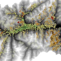
The aim of the geomorphometric analysis is to derive indices capable of characterizing the spatial variability of specific hydro-geomorphological processes (e.g., sediment connectivity, erosion and deposit). The growing availability of high-resolution topographic data has increased the interest in geomorphometry and its applications. Debris-flow monitoring in instrumented areas and flash-flood documentation are invaluable ways to gather field ...
This dataset consists of rainfall data and debris-flow hydrographs recorded in the Moscardo Torrent (Carnic Alps, northeastern Italy).
The Moscardo Torrent was instrumented for debris-flow monitoring by CNR IRPI (Torino office) in 1989; the research was then continued in collaboration with the Padova office. Since 2010 the monitoring activities are carried on in collaboration with the University of Udine (Dept. of Agricultural and ...
EPSILON Italia, the leader of the partnership proposing the project, is a SME, located in Calabria, specializing in the delivery of advanced services for the protection and management of natural resources, with a high standard of quality and technological content. The SME is also actively involved in the development and implementation of new technologies and in R&D activities conducted both in their own and in partnership with universities ...
With more than 5 million people affected, more than 1000 killed, and with estimated total damages exceeding 4.5 billion Euros just in Europe and during the last decade, floods are among the most disruptive natural events threatening our Society. Due to increase in extreme weather events and rapid socio-economic developments in vulnerable locations, the risks connected to floods in general are growing rapidly, and the awareness of these risks ...

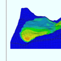
The 3DA software is a new procedure that allows retrieving in near-real-time 3D surface deformation models starting from data acquired via robotized total stations or others system that acquire the surface displacements. The measurements are first pre-processed and then implemented on 3D maps that include vector arrows representative of the intensities and of the real directions of motion in a given system of coordinates. The 3D surface ...
The hydro-meteorological monitoring is the operational tool for the measures of atmospheric, hydrologic ad hydraulic variables characterizing the hydrological cycle and it represents the grounds of IRPI’s research activities finalized to forecast, prevention and mitigation of natural hazards. Indeed, an accurate knowledge of processes at basis of natural phenomenon cannot disregard the direct measure of hydrological quantities, considering ...
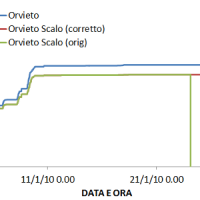
The analysis of hydro-meteorological data is required to verify the correct sensors functioning and possible presence of non-operational periods with missing data. When non-operational periods or malfunction occur, it could be possible to apply procedures for missing data reconstructions and wrong data ...
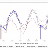
The activities of the project concerns the analysis and processing of hydro-meteorological data collected by the monitoring network of the Umbria Region for the period 1994-2014. In particular, the study regards the rainfall, temperature and water level time series. In addition, the discharge series corresponding to observed water levels are estimated for at hydrometric station through the rating curve estimated on the basis of flow velocity ...
The project activities concern:
development and implementation of: 1) a semi-distributed continuous hydrological model (MISDc) for real-time soil moisture estimate and river discharge prediction in the Upper-Middle Tiber River basin; 2) a flood wave routing model (STAFOM-RCM) for stage hydrograph forecasting at some selected hydrometric stations in the Tiber River basin;
support for installation of soil moisture sensors in the ...
In the spring of 2006, a large failure started moving in the Montaguto municipality, Campania, southern Italy, 40 km ENE of Benevento and 35 km SW of Foggia. The movement was a partial reactivation of an older mass movement in the same general area. In April 2010, the earthflow reached the Cervaro River valley, advancing at a maximum rate of approximately 5 ...
Following the recent technological development, the role of landslides monitoring has become increasingly important, especially for the study and management of large landslides in emergency scenarios. In the last decades, CNR IRPI developed a range of skills dedicated to the design, installation and management of monitoring systems that can be considered for a technical and scientific support in many national emergencies. CNR IRPI can apply ...
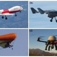
The environment monitoring has several purposes, including the prevention of geo-hydrogeological risks, forest fires, or prevention and suppression of illegal activities. The SMAT-F2 main objective is to define, design and develop an advanced monitoring system of the territory based on innovative unmanned air systems, coordinated by a supervision and coordination station (SSC). The first phase of the project, called SMAT-F1, finished at ...
In Italy landslides and floods are frequent, widespread and dangerous phenomena, that cause fatalities and serious economic damage. In our country, landslides and floods pose major problems of scientific interest and of social and economic relevance.
The Institute is a Competence Centre for the Italian national Civil Protection Department, an Office of the Prime Minister. For the Department of Civil Protection we execute research and ...
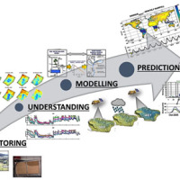
Large part of the territory is affected by geomorphological instability, often threatening the anthropic environment. Technical and socio-economic reasons often impose coexistence with the risks. Therefore, appropriate risk mitigation and/or reduction strategies must be implemented. Field and laboratory investigations, monitoring, modelling techniques and cartographic analyses are essential tools to acquire the necessary ...
There is a systematic lack of information on the effects of the climate and environmental changes on the frequency and the intensity of landslides and their triggering phenomena (Huggel et al., 2012). The problem is particular severe in mountain area, where natural and human-driven climatic and environmental changes may alter significantly the frequency and the intensity of the slope processes, with largely unknown short and long-term effects ...
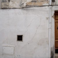
The instabilities that affected the historical part of Mesagne (Brindisi province, Apulia) since January 21, 2014, induced the local Authority to issue evacuation decrees for 18 families, corresponding to a total of 26 people. CNR IRPI was asked to provide scientific support for the identification of the processes at the origin of the ...
