
We monitor the Planpincieux Glacier, along the Italian side of the Grandes Jorasses, Aosta Valley
We use a high-resolution optical-based system to study the evolution of the Planpincieux glacier located on the eastern slope of the Grandes Jorasses, in the Mont Blanc massif.
Glaciers are typical of the Alpine landscape, and an important source of water. Undoubtedly fascinating, glaciers are very complex and yet surprisingly poorly known. In the Alps, many studies focus on the volumetric changes of glaciers, proving their almost systematic reduction in the current climatic period. Little is known about the daily behaviour of Alpine glaciers. This is partly due to the inhospitable and not easily accessible environment of the Alpine glaciers, that complicates their investigation.
The lower (terminal) part of an Alpine glacier can be very active, and characterized by the presence of crevasses and seracs, and collapse phenomena that make these areas difficult to access and very dangerous. The difficulty of access is greater if the glacier front is suspended, or placed along a steep slope.
To better understand the evolution of the front of an Alpine glacier, in collaboration with Fondazione Montagna Sicura, we designed and developed an experimental station to monitor the Planpincieux glacier, in the Grandes Jorasses, on the Italian side of the Mont Blanc massif.
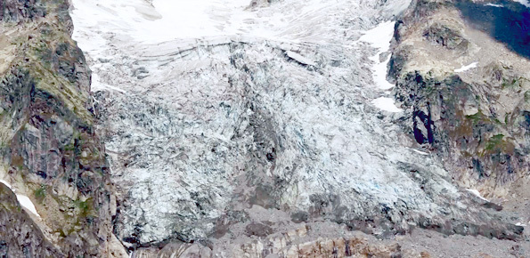
Planpincieux is a hanging glacier, with the front placed at a steep break in slope. The location, the very steep morphology of the front, and frequent local instabilities, make it impractical to install monitoring systems and tools on the front of the glacier. For this reason, before our project the information available on the rate of movement and the dynamics of the Planpincieux glacier was limited, fragmented and qualitative.
Video 1: Evolution of the Planpincieux Glacier in the Summer of 2015.
We designed and deployed a low-cost monitoring station capable of operating throughout the year at more than 2000 meters of elevation and in difficult climatic conditions. The monitoring station measures the movement of the front of the Planpincieux glacier, allowing for a better understanding of the processes governing the evolution of the glacier.
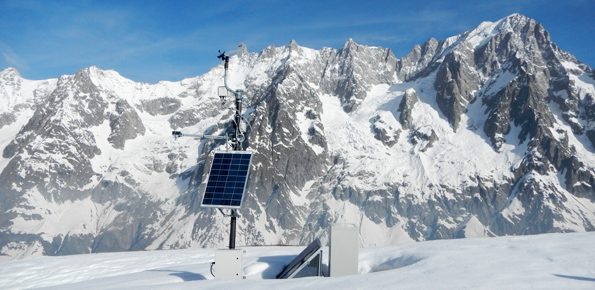
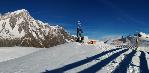
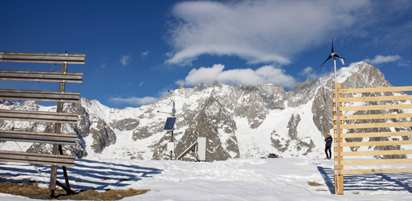
In September of 2013 we installed the monitoring station on the summit of Mont de La Saxe, facing the glacier at a distance of over 3.5 km from the Planpincieux glacier. The station consists of a meteorological station, a camera with zoon capability for the acquisition of optical images, and a second camera for the acquisition of high resolution optical images.
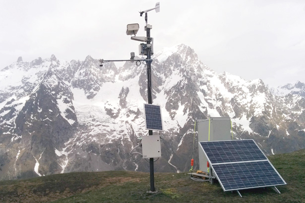
Figure 1: The monitoring station; in the background the Grandes Jorasses.
The monitoring station is powered by solar panels, and connected via UMTS to our lab in Turin. During the day, the system acquires a picture of Planpincieux glacier every hour. The images are transmitted to Turin where they are treated with “pixel offset” and “change detection” processing techniques that allow us to recognize and measure displacements of the glacier front.
Video 2: Displacements of the Planpincieux glacier.
The “pixel offset” technique allows to identify small variations between two successive images, and to measure the differences, allowing for the monitoring of the glacier over time.
The “change detection” technique allows to recognize sectors of the front of the glacier that have undergone changes in shape or color, giving us the ability to identify accurately areas which were subject of collapses.
Results
Between September 2013 and October 2015, we acquired more than 30,800 photographs of the front of the Planpincieux glacier. This unique sequence of images has allowed us to recognize and measure the processes governing the evolution of the glacier.
One of the most interesting and most spectacular characteristics of the Planpincieux glacier is the collapse of ice blocks.
Video 3: Collapse of a large ice block from the front of the Planpincieux glacier.
The collapse of ice blocks is particularly noticeable and frequent in this glacier because the frontal part of the Planpincieux glacier is resting on a very steep rocky slope that ends on an almost vertical rock wall. The glacier slides on the underlying rock and at the edge of the ravine it fragments into blocks that fall to the valley.
Video 4: Evolution of the front of the Planpincieux glacier.
Our monitoring station was able to acquire a long sequence of images useful for the recognition of the collapses, and to measure the displacements of the glacier, which are larger in the Summer. The movements measured with the “pixel offset” technique allowed us to prepare deformation maps like the one shown at Figure 2. The resolution of the system is about 5 cm/pixel. During Summer, the displacement rates have exceeded 30 cm per day.
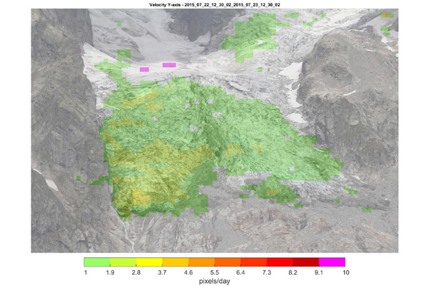
Figure 2: Map showing vertical displacements of the Planpincieux glacier.
With the support of the Valle d’Aosta Autonomous Region, the project that we have conducted in collaboration with Fondazione Montagna Sicura has allowed us to develop an innovative, low cost system to monitor the front of the Planpincieux glacier.
The technologies we have tested in the Planpincieux glacier can be exported for monitoring of other glaciers in the Alps and in other mountain ranges, and for monitoring of other gravitational phenomena.
Granting institutions
Project developed in cooperation with Fondazione Montagna Sicura, and co-founded by the Regione Autonoma Valle d’Aosta Regione Autonoma Valle d’Aosta.
 Contact person: daniele giordan -