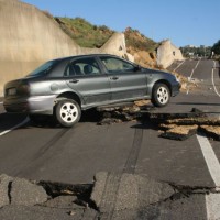
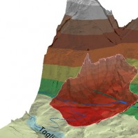
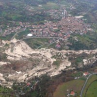
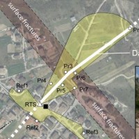
On December 3, 2013, a large landslide activated on the SW slope of Montescaglioso (Matera province, Basilicata), affecting an area with evidence of past instability. The landslide involved some 500 m of the main road to the village, and also interested several houses and other ...
The project AIM-DAMS is aimed at developing a laboratory of integrated and advanced environmental monitoring for the control of the behavior of the earth-dams due to the different factors acting on the dams during their lifetime. Based on the integration of innovative and non-invasive sensors, as well as recent monitoring techniques and numerical modelling, the project is intended to fulfill the need of the dam management agencies of using ...
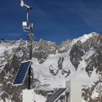
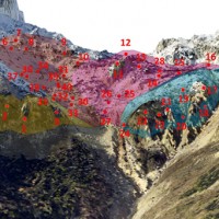
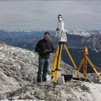
The Planpincieux Glacier is one of the glaciers that characterize the Italian side of the massif of the Grandes Jorasses. It is considered a temperate glacier and its front is currently located near a morphological step that determines a strong propensity to the activation of frequent ice falls in particular during the summer. These phenomena are typical of this glacier, but its particular asset may cause, as already occurred in the past, to ...
The project explores and implements multi-scale and multi-sensor SAR change detection methodologies for event landslide mapping. Automated analysis for change detection is a challenging task due
to the inherent noisiness of SAR imagery and also to the high sensitivity to texture variability due to different acquisition angles. Moreover, pre-processing (de-speckling) may lead to the degradation
of the geometrical details and affect the ...
Monitoring of debris flows in instrumented areas is carried out since many years in different Countries worldwide. It is still missing, however, an adequate standardization of methodologies, instrumentations and procedures. The instrumented areas are also employed for testing warning systems. Even though these latter have been more and more employed, a systematic experimentation of these systems has not yet been carried ...
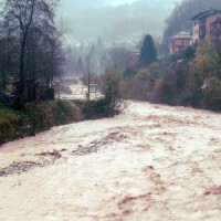
In the last decades Europe and Italy suffered many damaging floods, causing thousands of deaths, the displacement of millions of people and billions of euros in insured economic losses. Veneto Region has been also strongly stricken in 2010. The European Commission has identified the need for adaptation of risk management in several documents in order to reduce the likelihood and/or the impact of floods [1]. Starting from these remarks, the main ...
The Mont de La Saxe landslide affects the south-western side of Mont de La Saxe near Courmayeur, Valle d'Aosta. This landslide at present can be considered one of the most critical active landslides in the Italian Alps. The estimated unstable mass is more than eight millions of cubic meters and the main elements at risk are the hamlets of La Palud and Entreves, and the motorway access to the international tunnel of the Mont ...
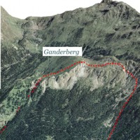
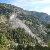
A Deep-seated Gravitational Slope Deformation (DGSD) affects the south-west flank of mount Ganderberg (Moso in Passiria – BZ). The continuous displacements of the landslide induce secondary hazardous phenomena. A 800.000 m3 rock slab shows signs of incipient movement; a detachment could create a natural barrier on the river ...
The entrance of the tunnel "San Lorenzo" in Forni di Sotto (UD) has built over a an active landslide body. The gravitational deformations of the slope are damaging the lining of the tunnel and creating a hazardous ...
At the beginning of November 2010 exceptional rainfall events stroke the Veneto Region causing the re-activation of the Rotolon landslide which is a serious threat to the town of Recoaro Terme, Vicenza, ...
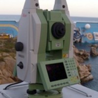
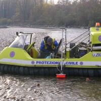
Following the run aground off near the "Isola del Giglio" (Tuscany, Italy, January 13, 2012) of the cruise vessel "Costa Concordia", a monitoring system for handling the security of the SAR (Search and Rescue) operations and for the control of the ships' movements/deformations during the subsequent defueling and recovery phases has been progressively installed and ...
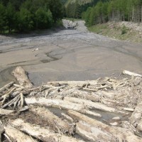
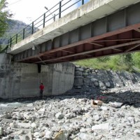
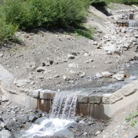
Sediment transport in small mountain catchments (drainage area < 10-20 km2) is a fundamental process for the equilibrium and the dynamics of the whole channel network. At the same time, sediment transport can create high-risk conditions due to the occurrence of extreme phenomena such as debris flow, hyperconcentrated flow, and flood with intense bedload, usually triggered by intense and short duration rainfall. In order to properly manage ...
Sinkholes are in Apulia among the main geohazards, and are at the origin of severe interactions with the anthropogenic environment, and heavy losses to society. Since several years the territory of Marina di Lesina is diffusely affected by development of sinkholes (that have caused an emergency state to be declared), mostly concentrated near the Acquarotta Channel, linking the Lesina Lake to the Adriatic ...
In the winter of 2009-2010, after the previous winter 2008-2009 when widespread hydrogeological instabilities had affected the whole of Calabria, the same area was still hardly hit by numerous and heavier instability phenomena, punctual and areal. In the context outlined it was ordered by the Italian Government to draft a "Plan excerpt for urgent action" which covered, in particular, the main city of the region, Catanzaro (Ianò district), and ...
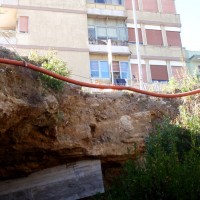
Sinkholes occur as sudden collapses of the ground, related to natural cavities produced by karst processes in soluble rocks, or to man-made cavities deriving from different types of human activities in different historical ages. Sinkholes are widespread all over the world, and the related hazard is extremely high, with very severe damage to built-up areas and human infrastructures, and heavy losses to the ...
The permafrost degradation is a probable cause of the increase of rock instabilities and rock falls observed in recent years in high mountain areas. It causes the thaw of the ice filling rock discontinuities producing water that subsequently freezes again, inducing stresses that lead to rock falls. Rock-falls are among the most hazardous instability processes in high mountain environments because of their velocity and the difficulty to ...
Debris-flow monitoring in instrumented areas is an invaluable way to gather field data that may improve the understanding of these hazardous phenomena, as well as for the development of warning systems. The number of monitoring sites and the amount of recorded data on debris flows, however, still remain limited if compared to landslides and fluvial sediment transport. This motivated the Autonomous Province of Bozen-Bolzano to implement a new ...
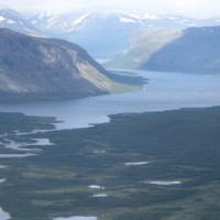
Fennoscandia bears witness of the Pleistocene glaciation in the form of a series of large geological faults. Pärvie which is the longest runs for 150 km. No information is available on its state of activity and no surface deformations data have ever been collected. The length of the fault and its location, make the traditional monitoring techniques unfeasible and ...

One of the main challenges in the field of engineering geology is the comprehension of the triggering mechanisms of landslides and the forecast of possible evolutionary scenarios in order to assess the correct mitigation measures. Landslides can be initiated by a variety of triggers: from earthquakes to meteorological events, including intense or prolonged rainfall, rapid snow melting, and variations of the surface temperature conditions. ...
The territory of Calabria is affected by numerous landslides and, more generally, has a strong propensity to develop hydrogeological instability. A measure of this condition is provided by the data of the current PAI, limited to the examined areas (villages and households with more than 200 inhabitants), that identifies over 1700 high-risk situations and more than 700 at very high risk: a total of over 2,400 situations in which a hazard to the ...
The L’Aquila earthquake occurred the 6th April 2009, causing several casualties and damages to a large number of buildings and infrastructures. The event was a 6.3 moment magnitude (Mw). In the days following the earthquake, several aftershocks with Mw>4 affected the same general area. In total, within an area of about 50 km radius from L’Aquila town, the seismic sequence counted ca. 2×10⁴ events in about one year. Among the severely ...
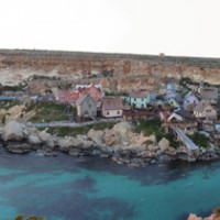
The research project can be included within the context of increasing hydrogeological instability also due to climate change and aims at investigating coastal instability in the island of Malta. This aspect has been until now slightly dealt with, despite significant risk issues, as evidenced from a series of accidents/damages recorded after landslide ...
Permafrost is very sensitive to climate change and the risks associated with its degradation affect traffic routes, settlements and infrastructure. Data on the distribution of permafrost are inconsistent and there is no common strategy to tackle this problem. Local administrators should have the means to manage the risks associated with the degradation of the ...
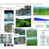
The Strategic Project PS_119 was aimed at developing a methodology for the landslide risk assessment, applicable at the regional scale and based on the most advanced knowledge in the fields of geology, geotechnics, structural engineering and urban planning. This assessment was based on a deterministic approach of the landslide processes and the risks related to them. The failure slope mechanisms, the structural damages due to landsliding and ...
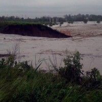
Flash-floods develop at space and time scales that conventional observation systems for rainfall and river discharge are not able to monitor. Consequently, the atmospheric and hydrological generating mechanisms of flash-floods are poorly understood, leading to highly uncertain forecasts of these ...
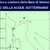
The project CISM faces problems related to marine Albanian waters in view of the Adriatic basin, which must meet various environmental problems in other portions of the Adriatic Sea, which are still influenced by the contribution of Albanian waters. CISM is not only a time of growth of the scientific culture of Albania, but also a landmark in the international scenario of the Adriatic ...
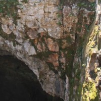
Evolution of cave and karst system occurs also by means of successive detachments of blocks from both the vault and the walls of the underground spaces. In show caves, this poses problems for the safety of visitors, and the issue must be carefully ...
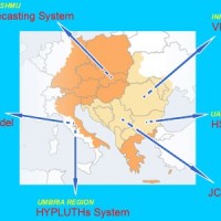
Hydrometeorological monitoring and flood forecasting are indispensable in preventing hydraulic hazard and ensuring civil protection. Implementing a sustainable plan to combat floods requires further activities, such as best practices for agricultural, forestry and land use management in flood risk areas. Methodologies must be developped within a transnational context, transending local ...
The study of the evolution of the watercourses is traditionally based on the use of historical maps and aerial photographs for the comprehension of the planimetric changes and on the use of topographical sections in order to have also the measure of the altimetric change occurred in the considered time interval.
Through this approach it is possible, for the Po basin, to have the first indications of the main watercourses evolution starting ...
