
In Italy
The coloured circles represent the total number of activities (project, products and services, outreach, collaborations) that we have in the corresponding geographical zone
Map data: © OpenStreetMap contributors
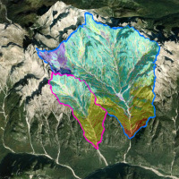
EGMS data in PAI planning tools
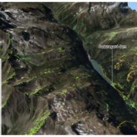 In recent decades, InSAR data has been extremely helpful in identifying and delineating active landslides, as well as enhancing our understanding of geo-hydrological instability. However, due to the complexity and limitations of interpreting InSAR data, there is a need for guidelines to facilitate its operational use in detecting slow landslide ...
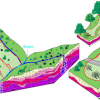
 Full cOveRage, Multi-scAle and multi-sensor geomorphological map: a practical tool for TerrItOrial plaNning
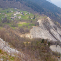
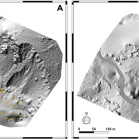
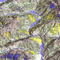
 Italy is an extremely fragile territory, widely exposed to hydrogeological hazards affecting anthropic infrastructures and the natural environment. In this scenario, geomorphological maps, including the representation of the spatial distribution of landforms, have been used for a long time for the description of processes acting on the Earth’s surface. Geomorphological maps should represent the basic tool for the assessment of ...
 Resilienza Strutture Alpine
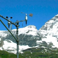
 Climate changes affecting the planet need to pay great attention to evaluate the related effects, primarily in mountain territories, first sentinels of climate change. The actively involvement of high-altitude refuges, a precious asset for weather and climate surveillance of the Italian mountains, need to increase and improve knowledges about climate change effects on these infrastructures, requiring specific assessment and investigation ...
 URban GEodiversity for a Resilient Environment
 Geodiversity refers to the variety of natural abiotic features, as the natural variety of geological (rocks, minerals), geomorphological (landforms, physical processes), hydrological and soil properties. The parameter “geomorphodiversity” is a measure of the dynamics of the Earth's surface and it has a key role in conservation of biodiversity and sustainability of ecosystems. Thus, it affects evolution of the biotic world and of human life. ...
 Prediction of Rainfall-INduced landslides – Improving multi-scale TerritoriAL Early warning through aRTificial intelligence
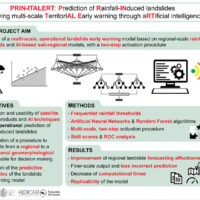 Predicting the occurrence of rainfall-induced landslides is a crucial task for civil protection purposes. Several landslide early warning systems are currently operating worldwide at different spatial scales. In Italy, landslide alerts are issued for territorial units named Alert Zones, covering a few thousand km². Usually, regional-scale warning models rely on rainfall thresholds, which require a few parameters and provide clear results in ...
 Sentinel-3 Topography mission Assessment through Reference Techniques
 The Copernicus Sentinel-3 Surface Topography Mission (STM) provides extremely valuable surface elevation information over inland waters, sea ice and land ice, thanks to its SAR altimeter which retrieves high-resolution along-track elevation measurements, and to its orbit that covers high-latitude polar regions.
To ensure that these measurements can be used with confidence, and to maximize the return on investment of the Copernicus Sentinel-3 ...
The Copernicus Sentinel-3 Surface Topography Mission (STM) provides extremely valuable surface elevation information over inland waters, sea ice and land ice, thanks to its SAR altimeter which retrieves high-resolution along-track elevation measurements, and to its orbit that covers high-latitude polar regions.
To ensure that these measurements can be used with confidence, and to maximize the return on investment of the Copernicus Sentinel-3 ... Gestione delle Monografie Operative relative ai grandi fenomeni franosi inseriti nella rete di monitoraggio della regione autonoma Valle d’Aosta
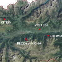 The Aosta Valley is a small alpine region affected by numerous landslides, varying in size and type, ranging from isolated rock falls to rotational/translational slides up to extensive deep landslides. The study of such landslides, functional to a more effective risk management and to guarantee adequate safety standards, represents a primary necessity for a mountain territory like this ...
 I-CHANGE project
Marta Chiarle, la geologa che cataloga le frane: «Sulle Alpi tanti cedimenti, ne abbiamo mappati 508»
 Dal sito del Corriere della Sera, intervista (del 1 luglio 2021, articolo pubblicato il 7 luglio 2021) a Marta Chiarle, ricercatrice presso l’IRPI CNR di Torino, che presenta il “Catasto delle frane di alta quota nelle Alpi” recentemente pubblicato a cura del gruppo di ricerca ...
 Which characteristics should optical satellite images have to detect and map landslides? It depends …
 Landslides leave discernible signs on the land surface, most of which can be captured in remote sensing images. On the images the signs appear as modification of the photographic characteristics as tone, colour, mottling and texture, or/and as modification of morphological characteristics including shape, curvature, convexity and concavity. These signs are the landslide signature. Trained geomorphologists analyse remote sensing images and map ...
 Laboratorio a Cielo aperto delle Grandes Jorasses per lo sviluppo di tecniche di monitoraggio di processi di instabilità in ambito glaciale
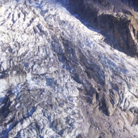 Climate change has a powerful impact on high-altitude Alpine sectors and glaciers. This impact often turns into an increase in instability processes that can lead to very high-risk conditions. These risk conditions can significantly affect the usability of areas characterized by intense tourist flows, making risk management very ...
 Effects of climate change on landslides
 Worldwide, landslides pose a serious threat to the population, causing fatalities, widespread damages, and significant economic losses. Different phenomena influence the stability of slopes and can cause landslides, among which the main factor is rainfall. Rainfall is strongly controlled and influenced by climate and its variations. Therefore, it is to be expected that climate changes influence slope stability at different temporal and ...
 Remotely Piloted Aircraft Systems for emergency response
 The use of remotely piloted aircraft systems (RPASs) in geosciences is often aimed at the acquisition of an image sequence to produce digital models and orthophotographs of the topographic surface. Such photogrammetric technique can be applied for rockfall hazard and risk assessment. To study rockfalls, an approach consists in the application of numerical models for the computation of rockfall trajectories. Data required for such simulations ...
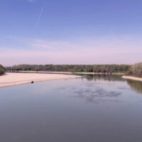
 River discharge estimation from satellite
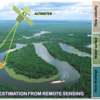 River discharge is defined as the amount of water flowing through a river over a specified period of time. Its estimate is crucial for all the operations of hydraulic structures design, the territorial planning and the flood risk assessment and management. River discharge at a specific river cross-section is not a direct measurement, but it is calculated by measuring other hydraulic quantities such as the flow velocity and the water depth, i.e. ...
 The improvement of the expressive and learning abilities of the adult
 The researches and the experimentations carried out, in the learning field, by the IRPI Institute during the last years, started out initially in the field of geoethics, have allowed to set up principles and didactic tools that offer today practical and usable tools to significantly improve, in a relatively short period of time, the expressive, learning and assimilation capacities of students and adults.
The researches have been originally ...
The researches and the experimentations carried out, in the learning field, by the IRPI Institute during the last years, started out initially in the field of geoethics, have allowed to set up principles and didactic tools that offer today practical and usable tools to significantly improve, in a relatively short period of time, the expressive, learning and assimilation capacities of students and adults.
The researches have been originally ... What’s underneath?
 When soil behaviour is studied, whether landslide soils are concern, levee materials or foundations, the problem regarding how much and how reliable information about the soil properties we have available has to be addressed.
Understanding “what’s beneath” the visible surface is fundamental, yet complicated. Drillings are performed to analyse the stratigraphy of soils (the order and the thickness of the different soil levels) and ...
When soil behaviour is studied, whether landslide soils are concern, levee materials or foundations, the problem regarding how much and how reliable information about the soil properties we have available has to be addressed.
Understanding “what’s beneath” the visible surface is fundamental, yet complicated. Drillings are performed to analyse the stratigraphy of soils (the order and the thickness of the different soil levels) and ... Damaging geo-hydrological events in Calabria from 1990 to 1999
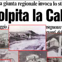 We published a book entitled “Eventi alluvionali in Calabria nel periodo 1990-1999” (Alluvial events in Calabria from 1990 to 1999)
Link to the Book»
The volume is the result of a study that lasted more than a year, and was part of long-lasting research effort to investigate historical landslide and flood events in Calabria, which started in the ‘70s of last century.
To search the information, we went to the Public Provincial ...
We published a book entitled “Eventi alluvionali in Calabria nel periodo 1990-1999” (Alluvial events in Calabria from 1990 to 1999)
Link to the Book»
The volume is the result of a study that lasted more than a year, and was part of long-lasting research effort to investigate historical landslide and flood events in Calabria, which started in the ‘70s of last century.
To search the information, we went to the Public Provincial ... Historical landslides and floods in Calabria
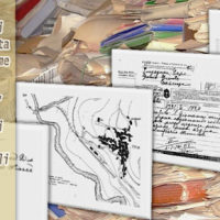 Landslides and floods tend to hit places that by their nature and geographic location are more likely than others to be damaged. Knowing the location of these places, and how they have been affected in the past by landslides and floods, allows to draw damage scenarios for possible future events.
For years, we have studied historical landslide and flood events in Calabria. Our investigations have allowed us to reconstruct a unique historical ...
Landslides and floods tend to hit places that by their nature and geographic location are more likely than others to be damaged. Knowing the location of these places, and how they have been affected in the past by landslides and floods, allows to draw damage scenarios for possible future events.
For years, we have studied historical landslide and flood events in Calabria. Our investigations have allowed us to reconstruct a unique historical ... How much Mar Piccolo peculiarities are due to groundwater outflow
 The Mar Piccolo basin is an internal sea basin located along the Ionian coast (Southern Italy), and it is surrounded primarily by fractured carbonate karstic environment.
In primarily karstic environments, infiltration is greater than runoff; in the karstic coastal Apulian aquifers, the groundwater discharge to the sea is more than two-fold greater than the surface discharge, notwithstanding the high discharges by wells. In such ...
The Mar Piccolo basin is an internal sea basin located along the Ionian coast (Southern Italy), and it is surrounded primarily by fractured carbonate karstic environment.
In primarily karstic environments, infiltration is greater than runoff; in the karstic coastal Apulian aquifers, the groundwater discharge to the sea is more than two-fold greater than the surface discharge, notwithstanding the high discharges by wells. In such ... Chronological database of sinkholes in Italy
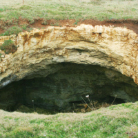 Sinkholes occurrence is related to the presence of an underground cavity, from which instability starts and propagate upwards until causing the collapse of the surface soil layer. The cavity may have a natural or artificial origin. Natural caves are due to presence of soluble rocks, and are typical of karst settings, where most of the sinkholes occur for dissolution processes. Man has excavated Anthropogenic cavities, for different purposes and ...
 Active alluvial fans in Calabria, Southern Italy
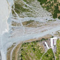 Alluvial fans are known to be areas of high geomorphic activity, where debris flows and flash floods caused by intense and prolonged rainfall are a major hazard. In Calabria, southern Italy, alluvial fans are numerous. The exact age of the alluvial fans is seldom known, but most of the fans in Calabria are considered recent in age (Holocene).
Due to the significant increase in urbanization in the last two centuries, many alluvial fans are ...
Alluvial fans are known to be areas of high geomorphic activity, where debris flows and flash floods caused by intense and prolonged rainfall are a major hazard. In Calabria, southern Italy, alluvial fans are numerous. The exact age of the alluvial fans is seldom known, but most of the fans in Calabria are considered recent in age (Holocene).
Due to the significant increase in urbanization in the last two centuries, many alluvial fans are ... Automated Inclinometer System (AIS) for deep-seated ground deformation measurements
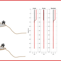 Our AIS (Automated Inclinometer System) allows for fully automatic inclinometer measurements in standard boreholes. The deep measurements have multiple applications, including (i) evaluating the rate of deep-seated ground deformation in landslide areas, (ii) evaluating the volume of deep-seated landslides, and (ii) assessing landslide hazards.
The AIS is composed of an electronic control manager, an inclinometer probe (with traditional ...
Our AIS (Automated Inclinometer System) allows for fully automatic inclinometer measurements in standard boreholes. The deep measurements have multiple applications, including (i) evaluating the rate of deep-seated ground deformation in landslide areas, (ii) evaluating the volume of deep-seated landslides, and (ii) assessing landslide hazards.
The AIS is composed of an electronic control manager, an inclinometer probe (with traditional ... Debris-flow monitoring in the Alps
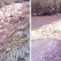 Not all that flows in creeks is water. Debris flows i.e., surges in which solid particles move together with little water, may occur in steep mountain streams, mainly as a consequence of intense rainfall. Debris flows have a high kinetic energy, and may cause major damage if they encroach buildings, roads and bridges. They are also a primary cause of landslide casualties. The video below shows an example of debris flows.
The low ...
Not all that flows in creeks is water. Debris flows i.e., surges in which solid particles move together with little water, may occur in steep mountain streams, mainly as a consequence of intense rainfall. Debris flows have a high kinetic energy, and may cause major damage if they encroach buildings, roads and bridges. They are also a primary cause of landslide casualties. The video below shows an example of debris flows.
The low ... Forecasting rainfall-induced landslides
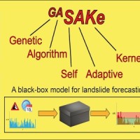 We developed GASAKe, Genetic Algorithm-based Self-Adaptive Kernel, a new model to predict the time of occurrence of rainfall induced landslides.
GASAKe predicts the time of occurrence of single landslides or groups of similar landslides, both shallow and deep-seated, using a threshold than when exceeded determines the initiation of the landslides. The triggering threshold is defined using historical information on rainfall and ...
We developed GASAKe, Genetic Algorithm-based Self-Adaptive Kernel, a new model to predict the time of occurrence of rainfall induced landslides.
GASAKe predicts the time of occurrence of single landslides or groups of similar landslides, both shallow and deep-seated, using a threshold than when exceeded determines the initiation of the landslides. The triggering threshold is defined using historical information on rainfall and ... Earthquake-induced landslides
 Landslides and earthquakes are important geological hazards in Italy, where mountains and hills dominate a landscape characterized by the presence of weak geological materials. The geological and morphological settings result in high susceptibility to landslides under seismic conditions. Italy is also one of the most active tectonic regions in Europe; and seismic shaking is known to have caused landslides in Italy.
Numerous historical ...
Landslides and earthquakes are important geological hazards in Italy, where mountains and hills dominate a landscape characterized by the presence of weak geological materials. The geological and morphological settings result in high susceptibility to landslides under seismic conditions. Italy is also one of the most active tectonic regions in Europe; and seismic shaking is known to have caused landslides in Italy.
Numerous historical ... Where we should not expect landslides?
 Landslide susceptibility is the propensity of a territory to generate landslides.
Many methods are available to determine landslide susceptibility, whereas only a few attempts were made to outline areas not likely to generate landslides i.e., non-susceptible landslide areas. This is surprising, because for planning purposes it is just as important (if not more important) to know where landslides are not expected than to know where landslides ...
Landslide susceptibility is the propensity of a territory to generate landslides.
Many methods are available to determine landslide susceptibility, whereas only a few attempts were made to outline areas not likely to generate landslides i.e., non-susceptible landslide areas. This is surprising, because for planning purposes it is just as important (if not more important) to know where landslides are not expected than to know where landslides ... The strong retreat of the Italian glaciers
 Between the late 19th and early 21st century, in the Alps the average air temperature has increased by about 2 °C, more than twice the increase in temperature in the northern hemisphere, of 0.8 °C. In the same period, precipitation showed a tendency towards an increase in the northern part of the Alps, and a tendency towards a decrease in the southern sector of the Alps.
Since the end of the Little Ice Age (about 1850), glaciers in the ...
Between the late 19th and early 21st century, in the Alps the average air temperature has increased by about 2 °C, more than twice the increase in temperature in the northern hemisphere, of 0.8 °C. In the same period, precipitation showed a tendency towards an increase in the northern part of the Alps, and a tendency towards a decrease in the southern sector of the Alps.
Since the end of the Little Ice Age (about 1850), glaciers in the ... ALMOND-F, an ALarm and MONitoring system for Debris-Flows
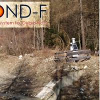 ALMOND-F is an innovative unit for the microseismic detection of debris flows using a network of geophones.
The microseismic detection of debris flows is more complex than other types of monitoring. Use of the geophones requires: (1) the selection of the level of amplification of the signal, which depends on the distance from the stream; (2) the selection of the sampling frequency of the seismic signal, which must be sufficiently high; (3) ...
ALMOND-F is an innovative unit for the microseismic detection of debris flows using a network of geophones.
The microseismic detection of debris flows is more complex than other types of monitoring. Use of the geophones requires: (1) the selection of the level of amplification of the signal, which depends on the distance from the stream; (2) the selection of the sampling frequency of the seismic signal, which must be sufficiently high; (3) ... POLARIS: POpuLutAtion at RIsk of geo-hydrological events in Italy
 Despite the large number and frequency of landslides and floods that affect our territories, and the information on landslides and floods available also online, the subject of geo-hydrological hazards remains poorly known to the Italian citizens. The lack of understanding reflects in the limited perception of the population on the geo-hydrological risks in Italy.
One reason for the lack of understanding is the way in which the subject of ...
Despite the large number and frequency of landslides and floods that affect our territories, and the information on landslides and floods available also online, the subject of geo-hydrological hazards remains poorly known to the Italian citizens. The lack of understanding reflects in the limited perception of the population on the geo-hydrological risks in Italy.
One reason for the lack of understanding is the way in which the subject of ... Droughts, desertification and climate change in Calabria, Southern Italy
 Using long-term rainfall records obtained by the rain gauge network of the former Italian Hydrographic Service, in cooperation with colleagues in other CNR Institutes (ISAC and ISAFOM), we have studied the changes in the rainfall regimes in Calabria, Southern Italy.
Applying appropriate statistical methods, we checked the completeness of the historical records, verifying consistency and missing values in the records. We used the obtained ...
Using long-term rainfall records obtained by the rain gauge network of the former Italian Hydrographic Service, in cooperation with colleagues in other CNR Institutes (ISAC and ISAFOM), we have studied the changes in the rainfall regimes in Calabria, Southern Italy.
Applying appropriate statistical methods, we checked the completeness of the historical records, verifying consistency and missing values in the records. We used the obtained ... Detecting rainfall from the bottom up
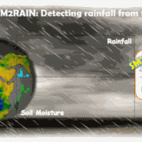 SM2RAIN is an innovative system for the estimation of the rainfall, based on measurements of the soil water content. SM2RAIN considers the soil as a natural rain gauge, and by measuring temporal variations of the soil water content, it estimates the rainfall falling on the soil, adopting a “bottom up” approach. Technically, SM2RAIN relies on the inversion of the soil water balance equation that computes the repartition of rainfall in ...
 Landslide susceptibility models and maps
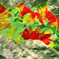 Landslide susceptibility is the likelihood of a landslide occurring in an area, given the local terrain conditions. It is the degree to which an area can be affected by future landslides i.e., an estimate of “where” landslides are more likely to occur.
Landslide susceptibility does not consider the temporal occurrence or the magnitude of the expected landslides. In mathematical language, landslide susceptibility can be expressed as the ...
Landslide susceptibility is the likelihood of a landslide occurring in an area, given the local terrain conditions. It is the degree to which an area can be affected by future landslides i.e., an estimate of “where” landslides are more likely to occur.
Landslide susceptibility does not consider the temporal occurrence or the magnitude of the expected landslides. In mathematical language, landslide susceptibility can be expressed as the ... Migliorare l’attenzione del pubblico per una più efficace comunicazione del rischio
 La sperimentazione ad ampio raggio condotta negli ultimi anni per testare sul campo la funzionalità e l’efficacia della procedura semplificata per la rielaborazione dei ricordi traumatici (RINOEL) ha consentito di evidenziare con sempre maggior chiarezza gli effetti esercitati da tali ricordi sull’attenzione di una persona. La capacità di concentrazione di un individuo, e dunque la sua abilità di focalizzare l’attenzione, risente ...
 Assessing sediment connectivity and availability in several mountain catchments in the Veneto Region
 Mass wasting is a threat to residential areas and infrastructure, causing widespread destabilization in alpine stream channels, also in relation to ongoing climatic changes. Although hillslope sediment supply represents a critical factor for stream channel stability during heavy rainstorms, there is a general lack of procedures for quantifying sediment availability and composition. Moreover, we lack validated empirical models for estimating ...
 Integrated multi-scale methods for seismically induced landslide hazard zonation
 The research activity aims at defining a coherent and unambiguous framework for the assessment and zonation of seismically induced landslides, at different geographical, temporal and management scales. To this end, the project works at the pre-event temporal scale, concerning spatial planning and soil protection and corresponding to years to decades time periods, and at the real-time or civil protection scale, corresponding to time periods ...
 MUltiHAzard framework for water related risks management
 The MUHA project is building upon the idea to address disaster management cycle consisting of preparedness-response-mitigation-rebuild components in the ADRION countries. It will connect the observed and modelled hazards and risks related to the integrated water cycle, by effectively join them with the existing and improved coping capacity developed by national, bilateral and EU Civil Protection ...
 Fiber optic sensors engineering for the monitoring of structural reinforcements on unstable slopes
 Geo-Hydrological risks are one of the main sources of economic losses for our country causing a huge number of victims and damages. From 1966 to 2015, landslides and floods caused 1948 casualties, 3524 injured and more than 412,000 displaced people. The Venetian mountain has always been subject to major landslides and, almost every year, new emergencies occur with the intensification of the autumn and spring rains, which are increasing due to ...
 Earth observation and climate change
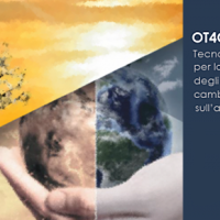 The OT4CLIMA project moves from the awareness that the impacts of climate change on the environment need to be better observed, understood, and modelled, especially at the local and regional scale, in order to put in place appropriate and effective risk mitigation ...
 IntEractions between hydrodyNamics and bioTic communities in fluvial Ecosystems: advancement in the knowledge and undeRstanding of PRocesses and ecosystem sustainability by the development of novel technologieS with fIeld monitoriNg and laboratory testinG
 The development of an innovative system for monitoring river flows during extreme events and the impact of hydrodynamic pressures on ecosystems are two important challenges identified by the World Meteorological Organization for flood event control and by the European Commission for the European Biodiversity Strategy for the protection of ecosystems and ...
 Valutazione del rischio idraulico finalizzata alla individuazione di interventi di mitigazione per la ricostruzione post-sisma
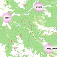 The seismic events that have affected central Italy since 24 August 2016 have caused extensive damage in the municipalities of Castelsantagelo sul Nera, Ussita and Visso (Marche Region). In order to proceed with the reconstruction, it is necessary to carry out interventions to reduce the hydraulic risk in urban ...
 Progetto ADAPT
 The ADAPT project, co-funded by the Interreg Italy-France Maritime Program 2014-2020, aims to adapt the Italian and French cities of the Upper Tyrrhenian to the consequences of climate change, with particular reference to the urban flash floods caused by intense meteorological ...
 Typify geo-hydrological events
 A Geo-hydrological event (EDId) (landslides, mass movements, floods, etc.) can result in a high social and economic impact, especially if it is generated by multiple simultaneous phenomena, when it is able to produce social hardships and economic damage characterized by important and lasting effects. The identification of the typical elements of the phenomena that can contribute to an EDId (typify) is essential to adequately define the risk ...
 Risk Management System (RMS)
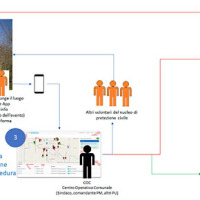 The management of emergencies, in particular those determined by natural events, is complex and must be able to use all the available cognitive elements. During emergencies, it is possible to acquire useful data regarding the processes that determine the same emergencies. These data can contribute to significantly improve planning and design of prevention ...
 Monitoring and landslides risk in the Maierato area
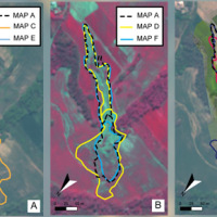
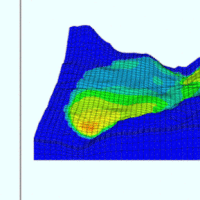
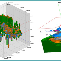
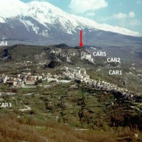
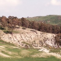
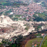 The Maierato landslide (Vibo Valentia Province) is a complex movement, which involved a significant thickness of geomaterials (rocks and soils) and rapidly flowed away for one kilometre. Owing that, the surrounding zone is interested by the same geological settings that predisposed the Maierato landslide, it is useful to identify any elements indicative of the presence of instabilities that can be triggered and evolved as the Maierato ...