
Projects
Geothermal Atlas of Southern Italy Project
 The Geothermal Atlas project is aimed at the characterization, classification and mapping of geothermal resources, conventional and unconventional types, for the production of electricity in the regions of Southern Italy. It also provides training and information stretched to increase the skills of the industry and the public's knowledge about the various aspects of geothermal energy, especially the unconventional, in order to promote the ...
 La Ricerca ITaliana per il MARE
 UK The Italian maritime cluster represents for Italy an important economic sector contributing to 2.6% of national GDP, 11% of production in the industry of transport, and using almost 1% of the units of work identified in the country, share as high as 2% including the impact of upstream and downstream, for a total of around 480,000 employees (Cluster and maritime development in Italy and in the regions CENSIS - September 2011). In the European ...
 Rainfall, seismicity, landslides and sediment discharge in mountain belts
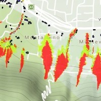
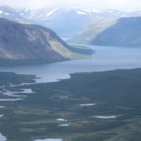
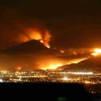
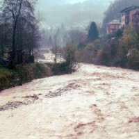
 Taiwan, an active orogenic belt with subtropical climate is characterized by a high uplift rate and several major typhoons each year. Italy is on one of the most seismically active regions in Europe because of the thrust of African plate on Eurasian continental one. Both experience numerous landslides along with earthquakes and intense rainfalls, causing heavy damages and casualties. The purpose of this project was to share scientific knowledge ...
 Assessment of water Balances and Optimisation based Target setting across EU River Basins
 ABOT is one of the Pilot projects on Development of Prevention Activities to Halt Desertification in Europe, partly funded by DG Environment of the European Commission. The objective of the pilot projects is to support the development of concrete pilot initiatives on innovative technologies, techniques or practices in order to contribute to the exchanges of good practice and innovation for halting the desertification in ...
 Management of sediment transport in small mountain catchments
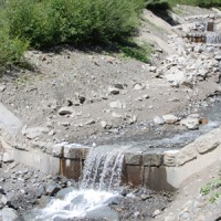
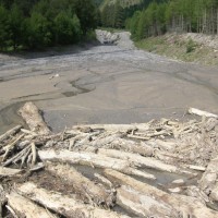 Sediment transport in small mountain catchments (drainage area < 10-20 km2) is a fundamental process for the equilibrium and the dynamics of the whole channel network. At the same time, sediment transport can create high-risk conditions due to the occurrence of extreme phenomena such as debris flow, hyperconcentrated flow, and flood with intense bedload, usually triggered by intense and short duration rainfall. In order to properly manage ...
 Sinkholes in the Marina di Lesina area
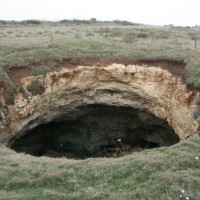
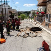
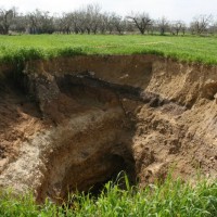
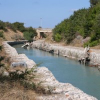 Sinkholes are in Apulia among the main geohazards, and are at the origin of severe interactions with the anthropogenic environment, and heavy losses to society. Since several years the territory of Marina di Lesina is diffusely affected by development of sinkholes (that have caused an emergency state to be declared), mostly concentrated near the Acquarotta Channel, linking the Lesina Lake to the Adriatic ...
 The Via Firenze Sinkhole of in the Municipality of Gallipoli
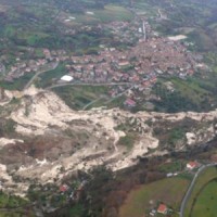
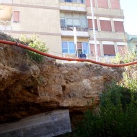
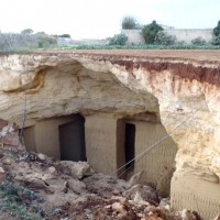
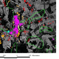
 Among the most recent sinkhole events, registered in Apulia region, that occurred in Via Firenze at Gallipoli on March 29, 2007, greatly raised the attention by public opinion, having affected (likely, without causing any fatalities) the built-up areas of one of the largest towns in Salento. The event pointed out to the need to carry out detailed studies on the sinkholes related to artificial ...
 Geomorphological studies on sectors of the Apulian territory
 Existing geomorphological maps on the Apulian territory show some inconsistencies, that might have effects as concerns the limits of restriction areas for the location of works. To have available an updated and scientifically sound product, TRE Spa asked CNR IRPI a scientific consultancy for the production of geomorphological ...
 Extraterrestrial landslides
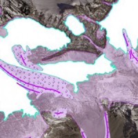
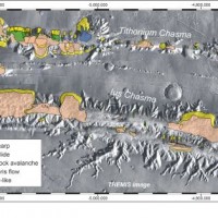 Landslides play an important role in the evolution of landscapes on Earth and on other solid planets of the Solar System. Surface gravity is the main factor driving landslides in solid planets. On Earth, landslides have been recognized in all continents, and in subaerial and submarine environments. The spatial and temporal range of the observed slope failures is extremely large on Earth. We are conducting a systematic mapping of landslides in ...
 Changing Hydro-meteorological Risks as Analyzed by a New Generation of European Scientists
 The European Commission has identified the need for adaptations in risk management as a consequence to climate and environmental changes in several documents. The implementation of risk management measures such as disaster preparedness programmes, land-use planning, regulatory zoning and early warning systems are considered essential. Further, multi-risk assessment approaches are not used in planning practice: risk indicators are hardly used ...
 Register of the caves and artificial cavities of Apulia
 Within the framework of the project “Register of the Caves and Artificial Cavities of Apulia Region” (PO FESR 2007-2016), committed by the Ecology Service to the Apulian Speleological Federation (FSP), this latter involved CNR-IRPI to guarantee high scientific value to the documents to be produced, and to work with the cavers in the different phases of the ...
 Decision matrices for the assessment of fluvial processes in mountain streams
 Decision matrices may contribute to mountain watershed management by defining coherent event scenarios that take into account the type of flow processes (e.g., water floods with bedload, debris flows), their geomorphic effects, and the interactions with hydraulic control ...
 Investigations of the Ianò and Maierato landslides, Calabria, southern Italy
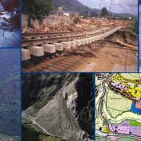
 In the winter of 2009-2010, after the previous winter 2008-2009 when widespread hydrogeological instabilities had affected the whole of Calabria, the same area was still hardly hit by numerous and heavier instability phenomena, punctual and areal. In the context outlined it was ordered by the Italian Government to draft a "Plan excerpt for urgent action" which covered, in particular, the main city of the region, Catanzaro (Ianò district), and ...
 Evaluating the geothermal potential in the Southern Regions of Italy
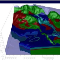
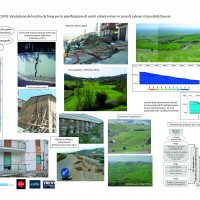
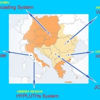
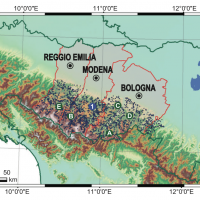
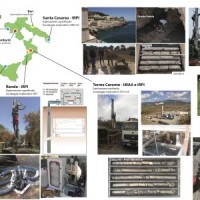 VIGOR contributed to increasing knowledge in exploitation of geothermal resources. It was aimed at providing information useful to start exploration and utilization of geothermal energy, through reconnaissance, analyses and studies, valorise geothermal resources in Calabria, Campania, Puglia and Sicily.
In particular, geological and geothermal characterization were carried both at regional scale (i.e. maps of geothermal potential) and at the ...
VIGOR contributed to increasing knowledge in exploitation of geothermal resources. It was aimed at providing information useful to start exploration and utilization of geothermal energy, through reconnaissance, analyses and studies, valorise geothermal resources in Calabria, Campania, Puglia and Sicily.
In particular, geological and geothermal characterization were carried both at regional scale (i.e. maps of geothermal potential) and at the ... Ground Deformations Risk Scenarios: an advanced assessment service
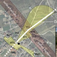
 DORIS - Ground Deformations Risk Scenarios: an advanced assessment service is an advanced downstream service for the detection, mapping, monitoring and forecasting of ground deformations, at different temporal and spatial scales and in various physiographic and climatic and environments. DORIS integrates traditional and innovative Earth Observation (EO) and ground based (non-EO) data and technologies to improve our understanding of the ...
 DInSAR techniques for the assessment of sinkhole hazard
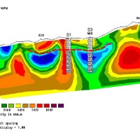
 Sinkholes occur as sudden collapses of the ground, related to natural cavities produced by karst processes in soluble rocks, or to man-made cavities deriving from different types of human activities in different historical ages. Sinkholes are widespread all over the world, and the related hazard is extremely high, with very severe damage to built-up areas and human infrastructures, and heavy losses to the ...
 Micro-seismic network at the Carrel Hut on the Matterhorn
 The permafrost degradation is a probable cause of the increase of rock instabilities and rock falls observed in recent years in high mountain areas. It causes the thaw of the ice filling rock discontinuities producing water that subsequently freezes again, inducing stresses that lead to rock falls. Rock-falls are among the most hazardous instability processes in high mountain environments because of their velocity and the difficulty to ...
 Monitoring system in the framewok of the Interreg IV Project “Monitor II”
 Debris-flow monitoring in instrumented areas is an invaluable way to gather field data that may improve the understanding of these hazardous phenomena, as well as for the development of warning systems. The number of monitoring sites and the amount of recorded data on debris flows, however, still remain limited if compared to landslides and fluvial sediment transport. This motivated the Autonomous Province of Bozen-Bolzano to implement a new ...
 Identification of the channel network in the Autonomous Province of Trento
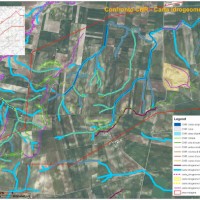
 The accurate representation of the channel network is fundamental in cartography. The increasing availability of high-resolution, LiDAR-derived DTMs provides an excellent topographic basis for the representation of the channel network, but requires innovative techniques for managing and processing ...
 GIS technologies for managing sinkhole hazard
 The widespread sinkholes that involve large sectors of the Apulian territory are related to natural cavities produced by karst processes in soluble rocks, or to man-made cavities deriving from different types of human activities in different historical ages. The related hazard is extremely high, with very severe damage to built-up areas and human infrastructures, and heavy losses to the ...
 Glacial hazards in the western Alps
 The project is included in Operative Program of the European cross-border territorial cooperation "Alcotra 2007-2013". It brings together specialized scientific expertise Italian and French that deal to study the mountain and its dangerousness. It is divided into a part of studies conducted on the entire framework of the Western Alps and in actions on the pilot sites identified by the ...
 Investigation of postglacial fault zones using DInSAR
 Fennoscandia bears witness of the Pleistocene glaciation in the form of a series of large geological faults. Pärvie which is the longest runs for 150 km. No information is available on its state of activity and no surface deformations data have ever been collected. The length of the fault and its location, make the traditional monitoring techniques unfeasible and ...
 Hazards in karst areas and mitigation strategies
 The high fragility of karst terrains, and the deriving vulnerability to a number of possible events, together with the presence of significant natural (first and foremost, groundwater), landscape and historical resources, are at the origin of the project activities, aimed at the safeguard of karst environments and the mitigation of the related ...
 Innovative System for Monitoring and assessment of hIgh risk LANDslides
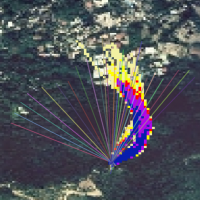
 One of the main challenges in the field of engineering geology is the comprehension of the triggering mechanisms of landslides and the forecast of possible evolutionary scenarios in order to assess the correct mitigation measures. Landslides can be initiated by a variety of triggers: from earthquakes to meteorological events, including intense or prolonged rainfall, rapid snow melting, and variations of the surface temperature conditions. ...
 Continuous monitoring of the seismogenic Paganica fault (AQ) after the April 6 2009 L’Aquila earthquake
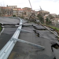
 The L’Aquila earthquake occurred the 6th April 2009, causing several casualties and damages to a large number of buildings and infrastructures. The event was a 6.3 moment magnitude (Mw). In the days following the earthquake, several aftershocks with Mw>4 affected the same general area. In total, within an area of about 50 km radius from L’Aquila town, the seismic sequence counted ca. 2×10⁴ events in about one year. Among the severely ...
 Triggering and evolution of the San Benedetto Ullano landslide
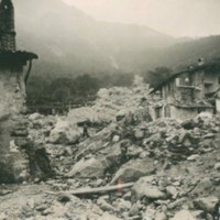
 With reference to landslides, Italy is exposed to high-risk conditions (Guzzetti, 2000). The abundant and prolonged rains fallen in the 2008-2009 and 2009-2010 wet seasons triggered numerous landslides in Calabria, mostly in its northernmost sector. Such geo-hydrological crises were severe enough to induce the Italian government to declare the State of Emergency on both ...
 Updating the list of Apulian municipalities with presence of man-made cavities
 The widespread occurrence of sinkholes related to man-made cavities in Apulia highlights the need to perform a careful reconnaissance of the artificial caves over the whole region, and of their stability conditions. Knowledge of the presence and typology of artificial cavity, and of its main features, is a mandatory step for the mitigation of the sinkhole ...
 Cassini Extended Mission
The project, funded by ASI under the coordination of INAF (Istituto di Astrofisica Spaziale), involved Italian research groups active in data analysis from Cassini-Huygens probe, orbiting around Saturn and its ...
Landslide hazard in coastal areas: the natural laboratory of the Malta island
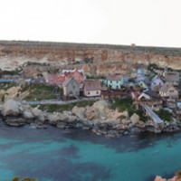 The research project can be included within the context of increasing hydrogeological instability also due to climate change and aims at investigating coastal instability in the island of Malta. This aspect has been until now slightly dealt with, despite significant risk issues, as evidenced from a series of accidents/damages recorded after landslide ...
 Design and restore underground
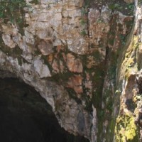
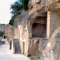 Puglia is one of the italian region with a higher density of hypogean sites of great value from the archaeological historical and artistic point of view. Many of them are in so precarious conditions that it is not possible to comprehend the precise history of the places and to define restoration interventions for their utilization and ...
 Long-term Permafrost Monitoring Network
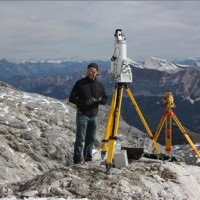 Permafrost is very sensitive to climate change and the risks associated with its degradation affect traffic routes, settlements and infrastructure. Data on the distribution of permafrost are inconsistent and there is no common strategy to tackle this problem. Local administrators should have the means to manage the risks associated with the degradation of the ...
 Prediction of rainfall-induced landslides and associated risk in Italy
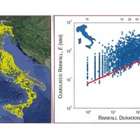 In Italy, slope failures occur every year, claiming lives, causing economic disruption, and producing different environmental problems. In Italy, intense or prolonged rainfall is the primary trigger of landslides. Predicting rainfall-induced slope failures is a challenging task of both scientific and societal interest. The forecast of single or multiple landslides triggered by rainfall in wide areas relies primarily on empirical rainfall ...
 Database of post-wildfire debris-flow activity in Mediterranean ecosystems
 Wildfires can have profound effects on the hydrologic response of watersheds, and debris-flow activity is among the most destructive consequences of these effects. The continued high likelihood of catastrophic wildfires in Mediterranean climates has created the need to develop methods to identify and quantify potential debris flow hazards from burned ...
 Mountain Risks: from prediction to management and governance
 The observed increase in disastrous events over the last decades, associated with a low perception of risk by the communities involved, along with the lack of efficient, socially accepted and environmentally sound remedial measures are amongst the motivation behind this research project. The adaptation of a combined multi-risk-oriented analysis, in which the investigations focus more on the interdependence of events rather than on single event, ...
 Progetto Presídi
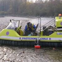
 Il progetto presidi soddisfa un’esigenza normativa (D.P.C.M. 27/02/2004) e conoscitiva della Protezione Civile Regionale del Piemonte; diventa uno strumento funzionale all’aggiornamento dei punti di criticità idrogeologica del territorio, individuati e verificati dopo una complessa indagine retrospettiva e lunga concertazione di diversi Enti territoriali competenti, e al loro monitoraggio durante le fasi parossistiche di eventi di piena o ...
 Landslide risk and urban planning in small settlements in Daunia
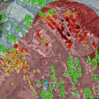
 The Strategic Project PS_119 was aimed at developing a methodology for the landslide risk assessment, applicable at the regional scale and based on the most advanced knowledge in the fields of geology, geotechnics, structural engineering and urban planning. This assessment was based on a deterministic approach of the landslide processes and the risks related to them. The failure slope mechanisms, the structural damages due to landsliding and ...
 Hydrometeorological data resources and technologies for effective flash flood forecasting
 Flash-floods develop at space and time scales that conventional observation systems for rainfall and river discharge are not able to monitor. Consequently, the atmospheric and hydrological generating mechanisms of flash-floods are poorly understood, leading to highly uncertain forecasts of these ...
 Albanian International Center on Marine Sciences
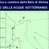 The project CISM faces problems related to marine Albanian waters in view of the Adriatic basin, which must meet various environmental problems in other portions of the Adriatic Sea, which are still influenced by the contribution of Albanian waters. CISM is not only a time of growth of the scientific culture of Albania, but also a landmark in the international scenario of the Adriatic ...
 Vulnerability maps for monitoring and management of groundwater resources in the Archimed area
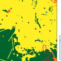 The project considered the strong demand of local institutions to select the best existing practices, in relation to different national and local characteristics, considering the regulatory ...
 Monitoring of the Castellana Caves
 Evolution of cave and karst system occurs also by means of successive detachments of blocks from both the vault and the walls of the underground spaces. In show caves, this poses problems for the safety of visitors, and the issue must be carefully ...
 Monitoring, Forecasting and Best Practices for FLOOD Mitigation & Prevention in the CADSES Region
 Hydrometeorological monitoring and flood forecasting are indispensable in preventing hydraulic hazard and ensuring civil protection. Implementing a sustainable plan to combat floods requires further activities, such as best practices for agricultural, forestry and land use management in flood risk areas. Methodologies must be developped within a transnational context, transending local ...
 Preliminary recognition of debris-flow hazard areas in Trentino
 The assessment debris-flow hazard is of utmost importance in the management of alpine catchments. The analysis of morphometric variables of drainage basins and channels can contribute to preliminary assessment of debris-flow hazard at regional ...
 Karst sinkholes in urban areas in Florida
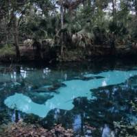 Sinkholes are among the main features of karst areas, and are extremely widespread in Florida, one of the sites most known for their occurrence and the likely interaction with the built-up environment. The Tampa area, in turn, shows an high frequency of events, which origin derives from different types of ...
 Landslide Early Warning Integrated System
 The focus on landslides results from the recognition that in many European countries slope instabilities affect urbanized areas and are a major threat to populations.
Through the integration of remotely sensed data with ground data we identify significant surface changes which are taking place on landslide susceptible slopes and this is used as input to the assessment of ...
The focus on landslides results from the recognition that in many European countries slope instabilities affect urbanized areas and are a major threat to populations.
Through the integration of remotely sensed data with ground data we identify significant surface changes which are taking place on landslide susceptible slopes and this is used as input to the assessment of ... Prevention, Information and Early Warning pre-operational services to support the management of risks
 PREVIEW is an integrated project by the European Commission 6th Framework Programme, led by the EURORISK Consortium, a multi-disciplinary European Team of committing Actors of the domain: Civil Protections and Environmental Bodies; Scientific communities and Service operators, at national and regional level, for Meteorology, Hydrology, Seismology, Volcanology and GIS services based on Space data; and Industry. The project was organized around a ...
 Extreme Events Causes and Consequences
 Extreme events are a key manifestation of complex systems, in both the natural and human world. Their economic and social consequences are a matter of enormous concern. Much of science has concentrated, until recently, on understanding the mean behaviour of physical, biological or social systems and their “normal” variability. Extreme events, due to their rarity, have been hard to study and even harder to predict. E2-C2 developed methods ...
 High pressure rheology
 Some geological phenomena of high pressure shearing show an unusual low friction during rock on rock slipping, like the abnormally long rock avalanches runout (hypermobility) or the slip of faults during earthquakes. The project aims to study the effect of the dynamic fragmentation of rock granules on the motion shear resistance, starting from the consideration that dynamic fragmentation is ubiquitous in geological processes subject to shearing ...
 Study of the riverbeds morphological evolution through the digital terrain models multi-temporal analysis
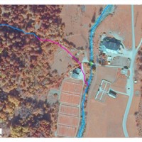
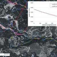
 The study of the evolution of the watercourses is traditionally based on the use of historical maps and aerial photographs for the comprehension of the planimetric changes and on the use of topographical sections in order to have also the measure of the altimetric change occurred in the considered time interval.
Through this approach it is possible, for the Po basin, to have the first indications of the main watercourses evolution starting ...
The study of the evolution of the watercourses is traditionally based on the use of historical maps and aerial photographs for the comprehension of the planimetric changes and on the use of topographical sections in order to have also the measure of the altimetric change occurred in the considered time interval.
Through this approach it is possible, for the Po basin, to have the first indications of the main watercourses evolution starting ... 

