Changing Hydro-meteorological Risks as Analyzed by a New Generation of European Scientists
(CHANGES)

Background
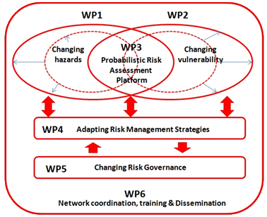
The European Commission has identified the need for adaptations in risk management as a consequence to climate and environmental changes in several documents. The implementation of risk management measures such as disaster preparedness programmes, land-use planning, regulatory zoning and early warning systems are considered essential. Further, multi-risk assessment approaches are not used in planning practice: risk indicators are hardly used and vulnerability indicators are not at all used. Therefore integrated approaches are needed for integrating spatial planning in disaster risk management. The CHANGES Network has been focused on the development of an integrated risk management approach applicable on both regional and local scales, which will combine the efforts undertaken so far.
Purpose
The CHANGES network will develop an advanced understanding of how global changes (related to environmental, climate and socio-economical change) will affect the temporal and spatial patterns of hydro-meteorological hazards and associated risks in Europe; how these changes can be assessed, modeled, and incorporated in sustainable risk management strategies, focusing on spatial planning, emergency preparedness and risk communication.
The main objectives are:
- To provide high-level training, teaching and research in the field of hazard and risk management in a changing environmental context to European young scientists.
- To reduce the fragmentation of research on natural processes, and
- To develop a methodological framework combined with modeling tools for probabilistic multi-hazard risk assessment taking into account changes in hazard scenarios (related to climate change) and exposed elements at risk.
Methods
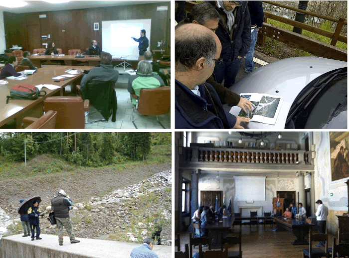
A Marie Curie Initial Training Network is inter-disciplinary and inter-sectorial project by nature. Therefore, the network consisted of 11 full partners and 6 associate partners of which 5 private companies, representing 10 European countries. It engaged 12 Early Stage Researchers (ESRs) as PhD candidates and 5 ESR for the development of the prototype decision support system of the project. Methods account for stakeholder involvement such as meetings, interviews, questionnaires, data collection exercises and feedback forms.
Results
- Analysis of the changes in the frequency, magnitude and extend of hydro-meteorological hazards, as a result of environmental changes.
- Analysis of the changes in exposed elements at risk and their vulnerabilities.
- Definition of probabilistic hazard scenarios.
- Definition of risk management strategies that will concentrate on spatial planning and emergency preparedness. The risk reduction measures are implemented in a Decision Support System (DSS).
Similarly to the other study areas, research activities have been carried out by a number of ESRs on the Fella area. Part of this work was done in combination with the INCREO project. The specific results for the Italian study area are:
- Comparing risk governance strategies, ESR Teresa Sprague (IRPUD, TU Dortmund, Germany)
- Risk information in spatial planning and SEA (Strategic Environmental Assessment), ESR Kathrin Prenger-Berninghoff (IRM, Institute of Urban Development, Poland)
- Land use change scenarios, ESR Ziga Màlek (IAASA and UNIVIE, Austria)
- Observed trends and future projections for rainfall debris flow and landslide events, ESR Thea Turkington (ITC Twente, The Netherlands)
- Debris flow hazard and risk assessment, ESR Haydar Hussin (CNR-IRPI, Perugia and ITC Twente, The Netherlands)
- Debris flows multi-scale vulnerability assessment with special focus on buildings, ESR Roxana Ciurean (UNIVIE, Austria)
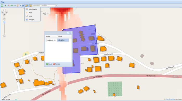
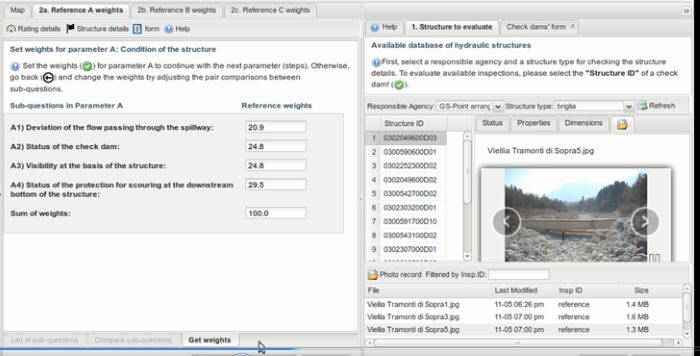
- Practical use of volunteers’ data for the inspection of hydraulic structures such a check dams: A pilot citizen science project. ESR Juliette Cortes (CNR-IRPI, Padova and TUDelft, The Netherlands)
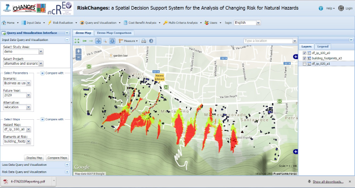
- A prototype web-based tool with modules for risk assessment and Collaborative decision making in selection of risk management strategies, ESR Zar-Chi Aye (University of Lausanne, Switzerland)
Products
Products and results are different in the test areas and are highly related to the work carried out by the Phd candidates. Products were presented to stakeholders with dissemination workshops. The goal was to provide information to the stakeholders whom had participated in early parts of the research process, to encourage discussion in order to incorporate their perspective, and to encourage more active involvement in the research results and their potential use.
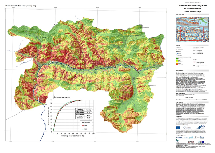
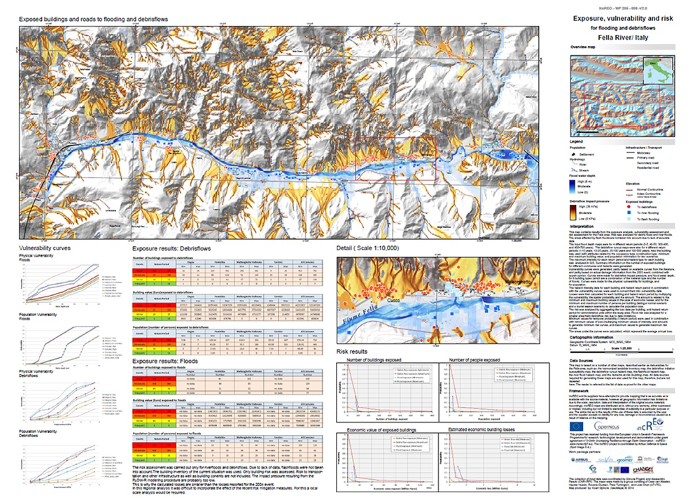
For the Fella area the following maps were produced:
- Maps for different land-use change scenarios
- Harmonized landslide inventory map;
- Debrisflow initiation susceptibility map;
- Debrisflow runout hazard map;
- Flood hazard map;
- Flashflood hazard modelling;
- Elements-at-risk map;
- Exposure and risk map.
Moreover, the following prototype tools we are produced:
- Inspection form and prototype web-based software for the first level inspections of check dams with the help of volunteers. (Initially developed for the Fella basin)
- A prototype web based tool for risk assessment and Collaborative decision making in selection of risk management strategies. (Developed for all study areas)
- Web based Changes-Spatial Decision Support System for Natural Risk Management. . (Developed for all study areas)
Pubblicazioni Journal:
- The connection between long-term and short-term risk management strategies for flood and landslide hazards: examples from land-use planning and emergency management in four European case studies (05 Dec 2014). K. Prenger-Berninghoff, V. J. Cortes, T. Sprague, Z. C. Aye, S. Greiving, W. Głowacki, and S. Sterlacchini. Nat. Hazards Earth Syst. Sci., 14, 3261-3278, 2014
- Cortes Arevalo, V. J., Charriere, M., Bossi, G., Frigerio, S., Schenato, L., Bogaard, T.,Bianchizza, C., Pasuto, A., and Sterlacchini, S.: Evaluating data quality collected by volunteers for first-level inspection of hydraulic structures in mountain catchments, Nat.Hazards Earth Syst. Sci., 14, 2681-2698, doi:10.5194/nhess-14-2681-2014, 2014.
Conclusions
The CHANGES network employed 17 Early Stage Researchers with the aims to:
- Develop the careers of young re¬searchers as experts in the field of natural risk assessment, management and mitigation;
- Increase the inter-sectorial mobility between academia and industry and international cooperation.
- Strengthen research capacity in multi¬-hazard risk assessment;
- Provide an e-learning package and open source tools.
Active stakeholders’ participation during research development stages and the dissemination of the project results are important features of the project. High-level training facilities as well as scientific and technological excellence were provided to the next generation of researchers in the field of hazard and risk management.