
Umbria
The coloured circles represent the total number of activities (project, products and services, outreach, collaborations) that we have in the corresponding geographical zone
Map data: © OpenStreetMap contributors
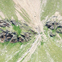
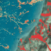
Which characteristics should optical satellite images have to detect and map landslides? It depends …
 Landslides leave discernible signs on the land surface, most of which can be captured in remote sensing images. On the images the signs appear as modification of the photographic characteristics as tone, colour, mottling and texture, or/and as modification of morphological characteristics including shape, curvature, convexity and concavity. These signs are the landslide signature. Trained geomorphologists analyse remote sensing images and map ...
 Landslide susceptibility models and maps
 Landslide susceptibility is the likelihood of a landslide occurring in an area, given the local terrain conditions. It is the degree to which an area can be affected by future landslides i.e., an estimate of “where” landslides are more likely to occur.
Landslide susceptibility does not consider the temporal occurrence or the magnitude of the expected landslides. In mathematical language, landslide susceptibility can be expressed as the ...
Landslide susceptibility is the likelihood of a landslide occurring in an area, given the local terrain conditions. It is the degree to which an area can be affected by future landslides i.e., an estimate of “where” landslides are more likely to occur.
Landslide susceptibility does not consider the temporal occurrence or the magnitude of the expected landslides. In mathematical language, landslide susceptibility can be expressed as the ... IntEractions between hydrodyNamics and bioTic communities in fluvial Ecosystems: advancement in the knowledge and undeRstanding of PRocesses and ecosystem sustainability by the development of novel technologieS with fIeld monitoriNg and laboratory testinG
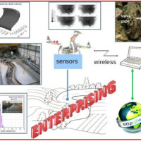 The development of an innovative system for monitoring river flows during extreme events and the impact of hydrodynamic pressures on ecosystems are two important challenges identified by the World Meteorological Organization for flood event control and by the European Commission for the European Biodiversity Strategy for the protection of ecosystems and ...
 Cartografia delle frane nell’area dell’invaso di Casanuova (PG)
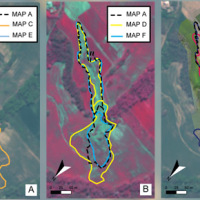
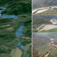
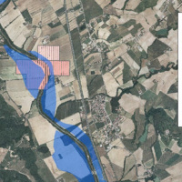
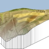
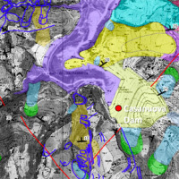 The reservoir of Casanuova on the Chiascio river, Central Umbria, occupies an area affected by numerous landslides, already identified in the regional cartographies. However, the potential interaction between the evolution of landslides and the reservoir is not evaluable because the available landslide inventories are not updated and do not contain information on the morphological evolution over time of the slopes that drain into the reservoir. ...
 Mappatura, Modellazione e Previsione Multiscala dei RIschi GEo-idroLogici
 Italy has a tradition of scientific research and technological development on hazardous natural phenomena in general, and specifically on geo-hydrological hazards. Within the CNR, the “Progetti Finalizzati” Soil Conservation and Geodynamics (in the ’70s and ’80s), and GNDCI – the National Group for the Defence from Hydrogeological Disasters (in the ’80s and ’90s), have contributed to the advancement of knowledge ...
 Multi Scale and Multi Hazard MApping Space Solutions
 The exploitation of innovative methods of SAR and optical data processing, combined to the use of ancillary data, is able to provide useful products for the landslide and seismic hazard ...
 Rafforzato il rapporto con il CNR
 Articolo del giorno 08/04/2015 del 'Corriere dell'Umbria' riguardante l'incontro del Presidente del CNR Luigi Nicolais e dei vari direttori del CNR di Perugia, con la Presidente della Regione Umbria Catiuscia Marini, avvenuto durante la mattinata del 7 aprile 2015 presso la sala conferenze ...
 Presidente Marini visita sedi e laboratori di Perugia
 Resoconto della visita del 7 aprile 2015 della Presidente della Regione Umbria Catiuscia Marini nei centri di ricerca del CNR di Perugia, tra i quali lo stesso IRPI, dove si è svolto per gran parte l'incontro con il Presidente del CNR Luigi Nicolais e i direttori dei vari ...
 Un ‘polo della ricerca’ in via del Giochetto con Università e Cnr
Articolo del quotidiano online 'Umbria24' sull'incontro, avvenuto il 7 aprile 2015, tra il presidente del CNR Luigi Nicolais e la presidente della Regione Umbria Catiuscia Marini, insieme con i diversi direttori degli istituti del CNR che operano in ... Control and validation of hydro-meteorological data
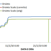 The analysis of hydro-meteorological data is required to verify the correct sensors functioning and possible presence of non-operational periods with missing data. When non-operational periods or malfunction occur, it could be possible to apply procedures for missing data reconstructions and wrong data ...
 Levees and bridges vulnerability
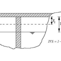 Assessment of bridge piers/abutments vulnerability to scour and overtopping hazard, assessment of levee vulnerability to seepage and overtopping hazard. The analysis is based on clearly identified criteria. Specifically, overtopping (IVS) and erosion (IVE) vulnerability indices are evaluated for each selected bridge, and the overtopping (IVsorm) and seepage vulnerability indices (IVsif) are calculated for the ...
 Flood events analysis
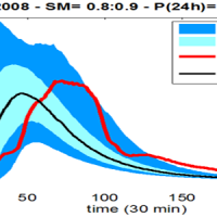
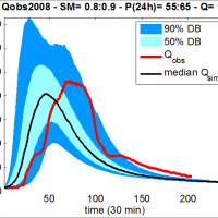
 The service is based on a procedure consisting of four main steps: the analysis of hydro-meteorological data for the reconstruction of flood event in terms of precipitations and saturation conditions of the soils; assessment of the hydrological response of the basin; runoff estimation in each hydrometric site of interest; flooded areas delineation and comparison with in-situ ...
 Climate change impact on extreme events
 The service analyzes the climate change impact on the main hydro-meteorological variables involved in the hydrological cycle and, in particular, on extreme events of rainfall and discharge (droughts and floods). The service allows to evaluate the combined effects of natural and human processes related to climate change on surface runoff and groundwater, analyzing the possible consequences of such effects on the strategic water ...
 Forecasting system for geo-hydrological risk
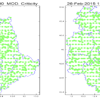 Real time evaluation of the rainfall and soil moisture conditions over the analysis grid point, and the combination with the available vulnerability and susceptibility information for the definition of the dynamic risk ...
 Hydraulic hazard maps
 Hydraulic hazard maps for return periods of 50, 100, 200 and 500 ...
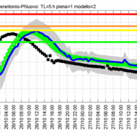
 Operational systems for flood wave forecasting (MISDc and STAFOM-RCM models) and flooding prediction (KS model)
 Semi-distributed continuous hydrological model (MISDc) for real-time soil moisture estimate and river discharge prediction in the Upper-Middle Tiber River basin; flood wave routing model (STAFOM-RCM) for stage hydrograph forecasting at some selected hydrometric stations in the Tiber River basin; Rainfall-runoff database coupled with the kinematic model KS for an expeditious estimate of probability flooding ...
 Siccità E Cambiamenti cLImatici
 SECLI Project is aimed to assess the combined effects of processes related to natural and anthropogenic climate change on water resources, both surface and groundwater, in the Umbrian territory, identifying the possible consequences of such effects on drinking water policy, and on how these may affect the existing system of withdrawals and ...
 Dynamic flooding scenarios
 The project activities were carried out in two phases:
"dynamic scenarios of flood risk" identification through hydrologic-hydraulic modeling addressed to Civil Protection activities (2009-2011);
operational implementation of developed dynamic scenarios of flood risk and results dissemination trough web-GIS technologies, also within the context of Floods Directive 2007/60 /EC (2012-203); flood forecasting models implementation; ...
The project activities were carried out in two phases:
"dynamic scenarios of flood risk" identification through hydrologic-hydraulic modeling addressed to Civil Protection activities (2009-2011);
operational implementation of developed dynamic scenarios of flood risk and results dissemination trough web-GIS technologies, also within the context of Floods Directive 2007/60 /EC (2012-203); flood forecasting models implementation; ... Flooding-prone areas delineation
 The project activities were carried out in two phases:
delineation of flooding-prone areas for many river reaches selected in the secondary hydrographic network of Tiber River basin (2009-2011);
analysis of the severe flood event that affected the Paglia river basin on November ...
The project activities were carried out in two phases:
delineation of flooding-prone areas for many river reaches selected in the secondary hydrographic network of Tiber River basin (2009-2011);
analysis of the severe flood event that affected the Paglia river basin on November ... Analysis, control and hydro-meteorological data processing – Rating curve estimate
 The activities of the project concerns the analysis and processing of hydro-meteorological data collected by the monitoring network of the Umbria Region for the period 1994-2014. In particular, the study regards the rainfall, temperature and water level time series. In addition, the discharge series corresponding to observed water levels are estimated for at hydrometric station through the rating curve estimated on the basis of flow velocity ...
 Flooding-prone areas delineation for hydraulic risk assessment for river reaches of the secondary hydrographic network in Tiber river basin
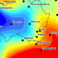
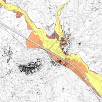
 The activities of the project concern the delineation of hazard maps for return periods of 50, 100, 200 and 500 years for many reaches of interest identified in the secondary hydrographic network of Tiber ...
 Hydrological and hydraulic studies to assess dam safety
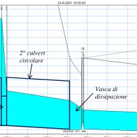 The artificial reservoirs are fundamental for water resources management, by regulating releases to meet the different users request (industrial, irrigation, hydropower, etc.), and for downstream territories floods defence through lamination of critical flood waves.
The main objective of the project concerns the review of hydrological-hydraulic studies carried out for the Montedoglio dam, on Tiber River, Casanuova dam, on Chiascio River, ...
The artificial reservoirs are fundamental for water resources management, by regulating releases to meet the different users request (industrial, irrigation, hydropower, etc.), and for downstream territories floods defence through lamination of critical flood waves.
The main objective of the project concerns the review of hydrological-hydraulic studies carried out for the Montedoglio dam, on Tiber River, Casanuova dam, on Chiascio River, ... Hydrological study of the Paglia river basin
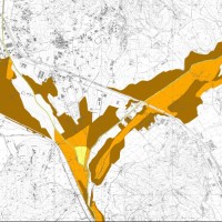
 The Tiber River Basin Authority (ABT) and the Umbria Region (Service Water Resources and Hydraulic Risk), considering the verified underestimation of the flood-prone areas in the Paglia River basin provided by the Italian PAI (hydro-geological management plan) and the update of rating curves, decided to revise the hydrological study of the drainage basin in order to re-estimate the flood hazard maps for the Paglia River reach bounded upstream ...
 Modelling for real-time flood forecasting
 The project activities concern:
development and implementation of: 1) a semi-distributed continuous hydrological model (MISDc) for real-time soil moisture estimate and river discharge prediction in the Upper-Middle Tiber River basin; 2) a flood wave routing model (STAFOM-RCM) for stage hydrograph forecasting at some selected hydrometric stations in the Tiber River basin;
support for installation of soil moisture sensors in the ...
The project activities concern:
development and implementation of: 1) a semi-distributed continuous hydrological model (MISDc) for real-time soil moisture estimate and river discharge prediction in the Upper-Middle Tiber River basin; 2) a flood wave routing model (STAFOM-RCM) for stage hydrograph forecasting at some selected hydrometric stations in the Tiber River basin;
support for installation of soil moisture sensors in the ... Upper-middle Tiber river basin: the flood event of 25-28 november 2005
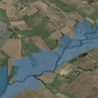
 On 25-27 November 2005, the territory of central Italy was affected by heavy rainfall that hit the Tiber River basin and, mainly, the province of Perugia. The meteoric event had a significant phase with a duration of approximately 48 hours with widespread precipitation up to a maximum accumulated value higher than 100 mm. Significant increases in water levels occurred in most rivers of Upper-Middle Tiber
causing extended flooding in ...
On 25-27 November 2005, the territory of central Italy was affected by heavy rainfall that hit the Tiber River basin and, mainly, the province of Perugia. The meteoric event had a significant phase with a duration of approximately 48 hours with widespread precipitation up to a maximum accumulated value higher than 100 mm. Significant increases in water levels occurred in most rivers of Upper-Middle Tiber
causing extended flooding in ... Monitoraggio del Rischio da Frane con tecnologie EO
 Le frane sono eventi del tutto naturali nell’evoluzione di un territorio, in particolare in Italia. Esse pongono un problema e diventano un pericolo allorché interagiscono con l’uomo e l’ambiente antropico. I movimenti franosi presentano una grande varietà fenomenologia. Le notevoli differenze nella tipologia, dimensione, e velocità di spostamento delle frane, rendono difficile e complessa la definizione della loro pericolosità, per ...
 20 years of continuous SAR observations benefit landslide studies
The European Space Agency (ESA), Earth Online web site (https://earth.esa.int/web/guest/pi-community/results) has picked and commented positively one of our latest papers published recently in the journal Remote Sensing of Environment 142 (2014), doi:10.1016/j.rse.2013.11.003. The paper deals with the exploitation of the ESA SAR data for the long-term monitoring of the Ivancich active landslide, Assisi, central ...
ITTS Volta e CNR IRPI per il futuro del monitoraggio idrogeologico
Articolo sulla Giornata di Studio CNR IRPI e ITTS A. Volta di Perugia tenutasi l'8 marzo 2014, pubblicato nel sito http://www.umbriajournal.com a firma Maria Cristina ... RelationsHips between meteo-climAtic paraMeters and ground surface deforMation time sEries in mountain enviRonments
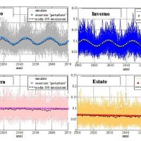
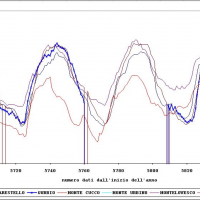
 There is a systematic lack of information on the effects of the climate and environmental changes on the frequency and the intensity of landslides and their triggering phenomena (Huggel et al., 2012). The problem is particular severe in mountain area, where natural and human-driven climatic and environmental changes may alter significantly the frequency and the intensity of the slope processes, with largely unknown short and long-term effects ...
 I sensori della Concordia per salvare San Giovanni
Articolo pubblicato nel Messaggero (Umbria) l'8 maggio 2013 che descrive le attività di monitoraggio della frana in località S. Giovanni Profiamma, nel Comune di Foligno (PG), che ha causato la chiusura della S.S. 3 Flaminia. Il Gruppo di Geomonitoraggio dell'Istituto ha installato una stazione totale robotizzata per il monitoraggio della ... Landslide Modelling and tools for vulnerability assessment Preparedness and REcovery management
 Il progetto FP7 LAMPRE - Landslide Modelling and tools for vulnerability assessment Preparedness and Recovery management svolge attività di ricerca innovative e di sviluppo tecnologico per migliorare le capacità del sistema Copernicus di far fronte a eventi di frana e alle loro conseguenze, in Europa e in altre parti del mondo. LAMPRE migliora il rischio di frana sforzi di mitigazione / preparazione e le attività di recupero e di ...
 Spatially distributed modelling of landslide phenomena
 The application of distributed physically based models is possible on relatively small areas, typically hundreds or few thousands of km2. Distributed modelling of slope dynamics requires many sufficiently detailed information. Knowledge of geotechnical parameters and land use, digital terrain models, medium/high resolution cartography, temporal evolution of soil moisture conditions, are ...
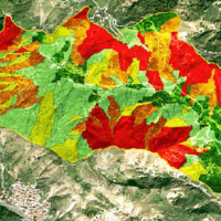
 Zonazione della suscettibilità da frana si scorrimento in Umbria
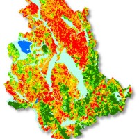 Realizzazione di modelli e carte di suscettibilità da frana tipo scorrimento per il territorio della Regione ...
 Ground Deformations Risk Scenarios: an advanced assessment service
 DORIS - Ground Deformations Risk Scenarios: an advanced assessment service is an advanced downstream service for the detection, mapping, monitoring and forecasting of ground deformations, at different temporal and spatial scales and in various physiographic and climatic and environments. DORIS integrates traditional and innovative Earth Observation (EO) and ground based (non-EO) data and technologies to improve our understanding of the ...