
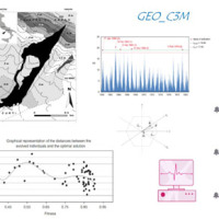
Calabria
The coloured circles represent the total number of activities (project, products and services, outreach, collaborations) that we have in the corresponding geographical zone
Map data: © OpenStreetMap contributors
Effects of climate change on landslides
 Worldwide, landslides pose a serious threat to the population, causing fatalities, widespread damages, and significant economic losses. Different phenomena influence the stability of slopes and can cause landslides, among which the main factor is rainfall. Rainfall is strongly controlled and influenced by climate and its variations. Therefore, it is to be expected that climate changes influence slope stability at different temporal and ...
 Damaging geo-hydrological events in Calabria from 1990 to 1999
 We published a book entitled “Eventi alluvionali in Calabria nel periodo 1990-1999” (Alluvial events in Calabria from 1990 to 1999)
Link to the Book»
The volume is the result of a study that lasted more than a year, and was part of long-lasting research effort to investigate historical landslide and flood events in Calabria, which started in the ‘70s of last century.
To search the information, we went to the Public Provincial ...
We published a book entitled “Eventi alluvionali in Calabria nel periodo 1990-1999” (Alluvial events in Calabria from 1990 to 1999)
Link to the Book»
The volume is the result of a study that lasted more than a year, and was part of long-lasting research effort to investigate historical landslide and flood events in Calabria, which started in the ‘70s of last century.
To search the information, we went to the Public Provincial ... Historical landslides and floods in Calabria
 Landslides and floods tend to hit places that by their nature and geographic location are more likely than others to be damaged. Knowing the location of these places, and how they have been affected in the past by landslides and floods, allows to draw damage scenarios for possible future events.
For years, we have studied historical landslide and flood events in Calabria. Our investigations have allowed us to reconstruct a unique historical ...
Landslides and floods tend to hit places that by their nature and geographic location are more likely than others to be damaged. Knowing the location of these places, and how they have been affected in the past by landslides and floods, allows to draw damage scenarios for possible future events.
For years, we have studied historical landslide and flood events in Calabria. Our investigations have allowed us to reconstruct a unique historical ... Active alluvial fans in Calabria, Southern Italy
 Alluvial fans are known to be areas of high geomorphic activity, where debris flows and flash floods caused by intense and prolonged rainfall are a major hazard. In Calabria, southern Italy, alluvial fans are numerous. The exact age of the alluvial fans is seldom known, but most of the fans in Calabria are considered recent in age (Holocene).
Due to the significant increase in urbanization in the last two centuries, many alluvial fans are ...
Alluvial fans are known to be areas of high geomorphic activity, where debris flows and flash floods caused by intense and prolonged rainfall are a major hazard. In Calabria, southern Italy, alluvial fans are numerous. The exact age of the alluvial fans is seldom known, but most of the fans in Calabria are considered recent in age (Holocene).
Due to the significant increase in urbanization in the last two centuries, many alluvial fans are ... Forecasting rainfall-induced landslides
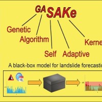 We developed GASAKe, Genetic Algorithm-based Self-Adaptive Kernel, a new model to predict the time of occurrence of rainfall induced landslides.
GASAKe predicts the time of occurrence of single landslides or groups of similar landslides, both shallow and deep-seated, using a threshold than when exceeded determines the initiation of the landslides. The triggering threshold is defined using historical information on rainfall and ...
We developed GASAKe, Genetic Algorithm-based Self-Adaptive Kernel, a new model to predict the time of occurrence of rainfall induced landslides.
GASAKe predicts the time of occurrence of single landslides or groups of similar landslides, both shallow and deep-seated, using a threshold than when exceeded determines the initiation of the landslides. The triggering threshold is defined using historical information on rainfall and ... Droughts, desertification and climate change in Calabria, Southern Italy
 Using long-term rainfall records obtained by the rain gauge network of the former Italian Hydrographic Service, in cooperation with colleagues in other CNR Institutes (ISAC and ISAFOM), we have studied the changes in the rainfall regimes in Calabria, Southern Italy.
Applying appropriate statistical methods, we checked the completeness of the historical records, verifying consistency and missing values in the records. We used the obtained ...
Using long-term rainfall records obtained by the rain gauge network of the former Italian Hydrographic Service, in cooperation with colleagues in other CNR Institutes (ISAC and ISAFOM), we have studied the changes in the rainfall regimes in Calabria, Southern Italy.
Applying appropriate statistical methods, we checked the completeness of the historical records, verifying consistency and missing values in the records. We used the obtained ... Earth observation and climate change
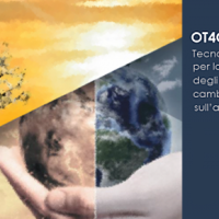 The OT4CLIMA project moves from the awareness that the impacts of climate change on the environment need to be better observed, understood, and modelled, especially at the local and regional scale, in order to put in place appropriate and effective risk mitigation ...
 Typify geo-hydrological events
 A Geo-hydrological event (EDId) (landslides, mass movements, floods, etc.) can result in a high social and economic impact, especially if it is generated by multiple simultaneous phenomena, when it is able to produce social hardships and economic damage characterized by important and lasting effects. The identification of the typical elements of the phenomena that can contribute to an EDId (typify) is essential to adequately define the risk ...
 Risk Management System (RMS)
 The management of emergencies, in particular those determined by natural events, is complex and must be able to use all the available cognitive elements. During emergencies, it is possible to acquire useful data regarding the processes that determine the same emergencies. These data can contribute to significantly improve planning and design of prevention ...
 Railways Meteo Security System
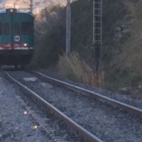
 In recent years, following short and intense meteoric events, along the railway line of the Department of Reggio Calabria, there have been a series of interruptions in correspondence of basins below 3-4 km2. Based on the current procedures for risk mitigation in RFI, in the event of a "red alert" issued by the Civil Protection, RFI management locate along the railway line personal in correspondence of the area in question. This procedure is ...
 From population risk perception to social vulnerability in coastal areas subject to climate change: a proposal for risk management strategies in two Mediterranean regions
 Coastal areas are particularly sensitive to climate change. Because these areas have become particularly susceptible to extreme physical phenomena because of a significant increase in human pressure, climate change will cause heightened exposure and vulnerability of the population. The Authorities ought to make strong efforts to: i) take the necessary measures and actions to reduce the negative impacts of the natural phenomena on the coastal ...
 Decree 473: early civil protection actions to cope with rainfall events that affected Calabria on November 2016 and January 2017
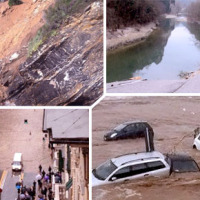
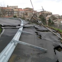
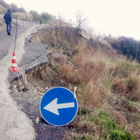 During about two months, two rain events that occurred in the periods 25-26 November 2016 and 22-25 January 2017 affected Calabria region, producing landslides and floods and causing huge damage on large ...
 Characterization, modelling and monitoring
 The project concerns the mitigation of natural hazards (mainly the effects on the territory and the anthropic environment caused by rains, earthquakes, volcanism, and Radon gas). The geological characterization is essential to frame the contexts and the expected phenomena. Numerical modeling and monitoring allow to predict the spatio-temporal evolution of the phenomena, and therefore to evaluate the risk for mitigation ...
 Progetto PON Governance
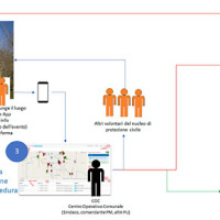
 Il progetto prevede un’attività di servizio e di supporto tecnico scientifico per la realizzazione di progetti standard che affrontano i temi della pianificazione comunale di protezione civile e degli strumenti che possono rendere maggiore la sua efficacia. Il progetto propone uno schema che consente di definire, con metodologia rigorosa e omogenea, le attività da svolgere e il modo in cui svolgerle, per la realizzazione di un modello di ...
 Smart Monitoring of basins subject to high geohydrological risk
 The R&D project SMoRI starts from two needs to be reconciled. The first, coming from the scientific community, concerns a best definition of integrated monitoring systems aimed at controlling the conditions of high geo-hydrological risk. The second need is to acquire by the industrial partners a specialized know-how on new technologies related to Cloud Computing and I.o.T. and on the environmental ...
 Hazard of alluvial fans
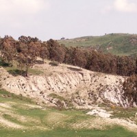
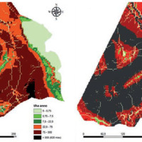
 In international literature, it is now widely recognized that alluvial fans are areas of high geomorphic activity. Debris flows and flash floods occur episodically in these environments, and place many communities at high risk. Calabria (southern Italy) is a region where alluvial fans widely occur. In this region, the presence of mountain fronts/alluvial and/or coastal plain, or deep and narrow valleys debouching into larger valleys are key ...
 Pilot Project “Mitigation of the desertification processes in Calabria, in areas with a very high vulnerability”
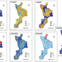
 Calabria is part of the 27% of the Italian territory deemed at desertification risk from the Plan of the National Area with Puglia, Sicilia and Sardegna. This project had a realization in an area called Valle dell’Esaro, close to Crotone, that is an area with high desertification risk. In fact, this area for its soil, climate, morphology characteristics and for the agricultural procedures represents the best site to test a model of good ...
 Identification and estimation of the parameters for assessing the risk of desertification
The Calabria region, because of its climatic, geomorphological and anthropic characteristics, is one of the regions most exposed to the risk of desertification in the Mediterranean basin. Methods already known in the literature and new approaches were applied at a basin scale on an area of the Ionian side, that, for rainfall and climatic characteristics, is one of the most exposed to this ... Methodology for the estimation of environmental risk indicators, using satellite remote sensing techniques
 EPSILON Italia, the leader of the partnership proposing the project, is a SME, located in Calabria, specializing in the delivery of advanced services for the protection and management of natural resources, with a high standard of quality and technological content. The SME is also actively involved in the development and implementation of new technologies and in R&D activities conducted both in their own and in partnership with universities ...
 Database of landslides in Calabria to be uploaded in the SyNaRMa computerized archives
 The purpose of Convention contracted between the Research Institute for Geo-Hydrologic Protection (Rende) and the Department of Physics of the University of Calabria for partnership in the Program CE INTERREG IIIB – ARCHIMED – SyNaRMa is to provide: i) the landslide-susceptibility maps for the different rock complexes of Calabria, ii) the definition of some important unstable slopes that can damage urban areas and main roads and railways of ...
 Alluvione Calabria: accordo tra Rfi, Cnr e Arpacal per la sicurezza della linea ferroviaria
 Articolo del 10 novembre 2015 tratto dal sito www.meteoweb.eu, riguardante la recente alluvione in Calabria, in cui si cita l'IRPI come uno dei tre enti che hanno aderito al progetto RAMSES (RAilway Meteorological SEcurity System), il cui Protocollo d’Intesa è stato firmato nei giorni scorsi.
Leggi l'articolo ...
Articolo del 10 novembre 2015 tratto dal sito www.meteoweb.eu, riguardante la recente alluvione in Calabria, in cui si cita l'IRPI come uno dei tre enti che hanno aderito al progetto RAMSES (RAilway Meteorological SEcurity System), il cui Protocollo d’Intesa è stato firmato nei giorni scorsi.
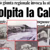
Leggi l'articolo ... “Tutti i corsi d’acqua della regione sono a rischio”
 Intervista a Carlo Tansi, della Sede Secondaria di Rende (CS) del CNR IRPI, su "Cronache del Garantista - Calabria" in relazione all'alluvione che ha colpito Corigliano e Rossano Calabro il 12 agosto ...
 Historical ARchive of COsenza
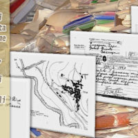
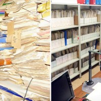 ARCO is the historical archive concerning the geo-hydrological events that occurred in Calabria (south Italy) between 1850 and 1990. The archive is made of 506 folders. 45 folders contain projects of land reclamation, management works of fluvial basins and refunding requests carried out after earthquakes. 461 folders, sorted per municipality, contain refunding requests due to geo-hydrological events, communications between citizens and public ...
 Innovative technologies at high environmental sustainability in the forest-based sector
 Millennium Ecosystems Assessment (ONU). Intergovernmental Convention on Climate and European Convention on the Protection of Forests. Integration of ground and remote technologies for Earth Observation and development of multi-resolution (spectral, spatial and temporal). Sustainable Forest Management (Ministerial Conference on the Protection of Forests in Europe). Decision support systems in the forest sector. Industrial technologies of the ...
 Investigations for the mitigation of geo-hydrological risk along the railway “Eccellente – Rosarno”
 Large part of the territory is affected by geomorphological instability, often threatening the anthropic environment. Technical and socio-economic reasons often impose coexistence with the risks. Therefore, appropriate risk mitigation and/or reduction strategies must be implemented. Field and laboratory investigations, monitoring, modelling techniques and cartographic analyses are essential tools to acquire the necessary ...
 Geothermal Atlas of Southern Italy Project
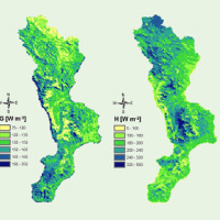
 The Geothermal Atlas project is aimed at the characterization, classification and mapping of geothermal resources, conventional and unconventional types, for the production of electricity in the regions of Southern Italy. It also provides training and information stretched to increase the skills of the industry and the public's knowledge about the various aspects of geothermal energy, especially the unconventional, in order to promote the ...
 Investigations of the Ianò and Maierato landslides, Calabria, southern Italy
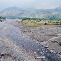
 In the winter of 2009-2010, after the previous winter 2008-2009 when widespread hydrogeological instabilities had affected the whole of Calabria, the same area was still hardly hit by numerous and heavier instability phenomena, punctual and areal. In the context outlined it was ordered by the Italian Government to draft a "Plan excerpt for urgent action" which covered, in particular, the main city of the region, Catanzaro (Ianò district), and ...
 Evaluating the geothermal potential in the Southern Regions of Italy
 VIGOR contributed to increasing knowledge in exploitation of geothermal resources. It was aimed at providing information useful to start exploration and utilization of geothermal energy, through reconnaissance, analyses and studies, valorise geothermal resources in Calabria, Campania, Puglia and Sicily.
In particular, geological and geothermal characterization were carried both at regional scale (i.e. maps of geothermal potential) and at the ...
VIGOR contributed to increasing knowledge in exploitation of geothermal resources. It was aimed at providing information useful to start exploration and utilization of geothermal energy, through reconnaissance, analyses and studies, valorise geothermal resources in Calabria, Campania, Puglia and Sicily.
In particular, geological and geothermal characterization were carried both at regional scale (i.e. maps of geothermal potential) and at the ... Triggering and evolution of the San Benedetto Ullano landslide
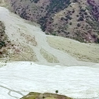
 With reference to landslides, Italy is exposed to high-risk conditions (Guzzetti, 2000). The abundant and prolonged rains fallen in the 2008-2009 and 2009-2010 wet seasons triggered numerous landslides in Calabria, mostly in its northernmost sector. Such geo-hydrological crises were severe enough to induce the Italian government to declare the State of Emergency on both ...
 Soverato: post alluvione
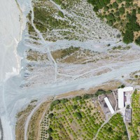
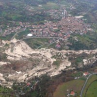
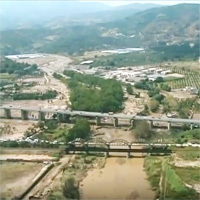 Riprese aeree effettuate dal CNR-IRPI il 10 settembre del 2000 sull'area di Soverato interessata dall'esondazione del torrente Beltrame. Il 9 settembre del 2000, una disastrosa alluvione colpì la parte nord di Soverato, facendo straripare il torrente Beltrame, distruggendo il Camping "Le Giare" e provocando 12 morti e 1 ...