
Theme: Civil Protection
Prediction of Rainfall-INduced landslides – Improving multi-scale TerritoriAL Early warning through aRTificial intelligence
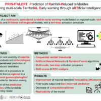 Predicting the occurrence of rainfall-induced landslides is a crucial task for civil protection purposes. Several landslide early warning systems are currently operating worldwide at different spatial scales. In Italy, landslide alerts are issued for territorial units named Alert Zones, covering a few thousand km². Usually, regional-scale warning models rely on rainfall thresholds, which require a few parameters and provide clear results in ...
 I-CHANGE project
Remotely Piloted Aircraft Systems for emergency response
 The use of remotely piloted aircraft systems (RPASs) in geosciences is often aimed at the acquisition of an image sequence to produce digital models and orthophotographs of the topographic surface. Such photogrammetric technique can be applied for rockfall hazard and risk assessment. To study rockfalls, an approach consists in the application of numerical models for the computation of rockfall trajectories. Data required for such simulations ...
 Overcoming together the traumas produced by natural disasters
 A recent research has been carried out by Marco Pagani, researcher of the Institute of Cognitive sciences and technologies of the Italian National Research Council (Istc-Cnr) in Rome. The research has documented, with electroencephalographic monitoring techniques (EEG), the cerebral effects deriving from the re-processing of a traumatic memory (https://www.cnr.it/it/news/5761/dall-emdr-un-aiuto-per-superare-i-traumi). In particular, the ...
 Detecting rainfall from the bottom up
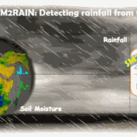 SM2RAIN is an innovative system for the estimation of the rainfall, based on measurements of the soil water content. SM2RAIN considers the soil as a natural rain gauge, and by measuring temporal variations of the soil water content, it estimates the rainfall falling on the soil, adopting a “bottom up” approach. Technically, SM2RAIN relies on the inversion of the soil water balance equation that computes the repartition of rainfall in ...
 Agreement with the Ligurian Regional Agency for Environmental Protection (ARPAL)
 Since 2013, CNR IRPI went in with the collection of information on rainfall events that have resulted in landslides in the Liguria region. Rainfall thresholds can be used in early warning systems for the prediction of the occurrence of rainfall-induced landslides. To respond to a request of the Italian national Department for Civil Protection (DPC), CNR IRPI designed and developed SANF, an Italian acronym for National Early Warning System for ...
 Sentinels for the Territory
 The knowledge of the geo-hydrological hazard of a territory and of the risk conditions for people, are essential for the implementation of civil protection activities. The monitoring activity by personnel, voluntary or not, is a strategic resource for all phases of civil ...
 Tessina and Lamosano Landslides Monitoring
 The Tessina Landslide has been, almost continuously, monitored by IRPI, Padova Unit, since its main reactivation in April 1992. Therefore the Veneto Region entrusted IRPI with the continuation of such activity to be extended to the Lamosano landslide too, in order to identify the most effective countermeasure to mitigate the induced ...
 Progetto PON Governance
 Il progetto prevede un’attività di servizio e di supporto tecnico scientifico per la realizzazione di progetti standard che affrontano i temi della pianificazione comunale di protezione civile e degli strumenti che possono rendere maggiore la sua efficacia. Il progetto propone uno schema che consente di definire, con metodologia rigorosa e omogenea, le attività da svolgere e il modo in cui svolgerle, per la realizzazione di un modello di ...
 Flood forecasting and hydraulic risk
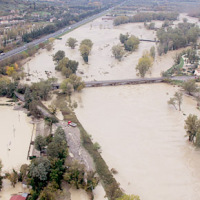 The project is focused on flood forecasting and hydraulic risk, i.e. the assessment of the effects of flooding in flood-prone areas also involving the vulnerability assessment of the hydraulic structures (dams, leaves, bridges, etc.).
The effects of flood events are not completely eliminated by structural measures, therefore it is necessary to develop complementary non-structural measures, such as real-time Flood Forecasting and Warning ...
The project is focused on flood forecasting and hydraulic risk, i.e. the assessment of the effects of flooding in flood-prone areas also involving the vulnerability assessment of the hydraulic structures (dams, leaves, bridges, etc.).
The effects of flood events are not completely eliminated by structural measures, therefore it is necessary to develop complementary non-structural measures, such as real-time Flood Forecasting and Warning ... Agreement with the Autonomous Region of Sardinia
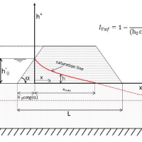
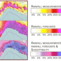
 In Italy, landslides are triggered by intense and/or prolonged rainfall. The spatial and temporal forecast of multiple landslides triggered by rainfall in wide areas relies primarily on empirical rainfall thresholds. It is widely believed that the thresholds are influenced by the local topographic (morphological), lithological, soil, and climatic settings. For this reason, it is necessary to define local rainfall thresholds. Reliable local ...
 Threedimensional Displacement Analysis
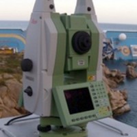
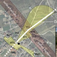
 The 3DA software is a new procedure that allows retrieving in near-real-time 3D surface deformation models starting from data acquired via robotized total stations or others system that acquire the surface displacements. The measurements are first pre-processed and then implemented on 3D maps that include vector arrows representative of the intensities and of the real directions of motion in a given system of coordinates. The 3D surface ...
 Sentinel for Geohazards regional monitoring and forecasting
 SAFETY aims at providing Civil Protection Authorities with the capability of periodically evaluating and assessing the potential impact of geohazards (volcanic activity, landslides and subsidence) on urban areas. The project improves the effort to detect and map geohazards, assess their activity and evaluate their impact on built-up areas and infrastructures ...
 H-SAF AS: Integration of PR-OBS-5 and SM-OBS-1 products through SM2RAIN algorithm for improving rainfall estimate
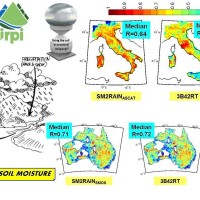 State-of-the-art satellite rainfall products are often the only way for measuring rainfall in remote areas of the world. However, these products may fail in properly reproducing the amount of precipitation reaching the ground, which is needed for hydrological applications. The integration of satellite soil moisture products is expected to significantly improve rainfall ...
 Use of SMAP soil moisture products for operational flood forecasting: data assimilation and antecedent wetness conditions assessment
 The project aims at using Soil Moisture Active and Passive (SMAP) soil moisture (SM) products at different spatial resolution (3, 9, and 36 km) for hydrological applications in Europe (mainly in ...
 Forecasting system for geo-hydrological risk
 Real time evaluation of the rainfall and soil moisture conditions over the analysis grid point, and the combination with the available vulnerability and susceptibility information for the definition of the dynamic risk ...
 Levees vulnerability database
 National levees database, where the levees are identified by a code consisting in two parts: the first one identifies the river; the second one is a sequential number increasing from downstream to upstream. For each levee the location, the characteristics and topographic surveys are reported along with vulnerability to overtopping and piping, flood hazard maps and information about levee inspection and ...
 Investigation of the Montaguto Landslide
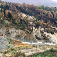
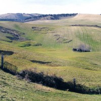
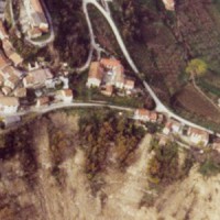
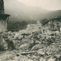
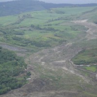 In the spring of 2006, a large failure started moving in the Montaguto municipality, Campania, southern Italy, 40 km ENE of Benevento and 35 km SW of Foggia. The movement was a partial reactivation of an older mass movement in the same general area. In April 2010, the earthflow reached the Cervaro River valley, advancing at a maximum rate of approximately 5 ...
 Landslide monitoring
 Following the recent technological development, the role of landslides monitoring has become increasingly important, especially for the study and management of large landslides in emergency scenarios. In the last decades, CNR IRPI developed a range of skills dedicated to the design, installation and management of monitoring systems that can be considered for a technical and scientific support in many national emergencies. CNR IRPI can apply ...
 Monitoraggio del Rischio da Frane con tecnologie EO
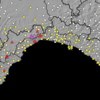
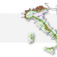 Le frane sono eventi del tutto naturali nell’evoluzione di un territorio, in particolare in Italia. Esse pongono un problema e diventano un pericolo allorché interagiscono con l’uomo e l’ambiente antropico. I movimenti franosi presentano una grande varietà fenomenologia. Le notevoli differenze nella tipologia, dimensione, e velocità di spostamento delle frane, rendono difficile e complessa la definizione della loro pericolosità, per ...
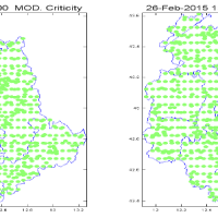
 SANF – Sistema di Allerta Nazionale per la previsione di Frane indotte dalla pioggia in Italia
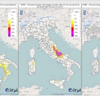 SANF is a landslide early warning system based on the comparison between rainfall measurements and forecasts and empirical rainfall thresholds. Specifically, the system consists of three components: (i) for rainfall and other data input and storage, (ii) for data processing and analysis, and (iii) for the production and delivery of the ...
 Civil Protection Competence Centre on Geo-Hydrological Risk
 In Italy landslides and floods are frequent, widespread and dangerous phenomena, that cause fatalities and serious economic damage. In our country, landslides and floods pose major problems of scientific interest and of social and economic relevance.
The Institute is a Competence Centre for the Italian national Civil Protection Department, an Office of the Prime Minister. For the Department of Civil Protection we execute research and ...
In Italy landslides and floods are frequent, widespread and dangerous phenomena, that cause fatalities and serious economic damage. In our country, landslides and floods pose major problems of scientific interest and of social and economic relevance.
The Institute is a Competence Centre for the Italian national Civil Protection Department, an Office of the Prime Minister. For the Department of Civil Protection we execute research and ... H-SAF and GPM: precipitation algorithm development and validation activity
 The proposal intends to contribute towards the establishment of a long-term partnership between the EUMETSAT Satellite Application Facility on support to Operational Hydrology and Water Management (H-SAF, or Hydrology SAF) and the NASA/JAXA Global Precipitation Measurement (GPM) ...
 Space advanced project for excellence in research and enterprise
The project SAPERE is an Industrial Research oriented project (PON and FAR funds) focused on promoting the competitiveness of the National Aerospace Technology Cluster. The participants to the project include 8 private firms of the Cluster (industrial component), with Thales Alenia Space Italia being the leader, as well as academic (University) and research (CNR-National Research Council) ...
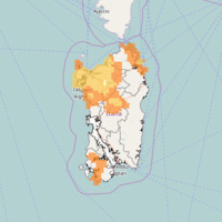
Rainfall thresholds for the possible initiation of rainfall-induced landslides in Apulia
 In Italy rainfall are among the main causes of trigger of shallow landslides, that yearly cause fatalities, damage, and severe economic losses. Identification of the amount of rainfall needed to trigger landslides, and the forecasting of rainfall-induced landslides, are of interest for the scientific community, as well as for the whole ...
 Ventennale dell’Alluvione in Piemonte del 1994
 Nel 2014 ricorrono vent’anni dalla tragica alluvione che nel novembre 1994 colpì gran parte del territorio piemontese, con perdita di vite umane, di beni mobili ed immobili. L’alluvione 1994 costituì altresì un momento storico nel campo della pianificazione territoriale, prevenzione e gestione della pericolosità e rischio geologico-idraulico, che si tradusse in dettami normativi, per l’epoca avanzati e lungimiranti. Da quell’evento ...
 SANF Liguria
 In Italy, landslides are triggered by intense and/or prolonged rainfall. The spatial and temporal forecast of multiple landslides triggered by rainfall in wide areas relies primarily on empirical rainfall thresholds. It is widely believed that the thresholds are influenced by the local topographic (morphological), lithological, soil, and climatic settings. For this reason, it is necessary to define local rainfall thresholds. Reliable local ...
 Analysis of the Mt. de La Saxe landslide
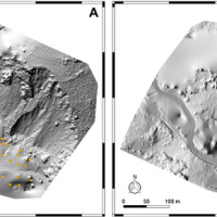
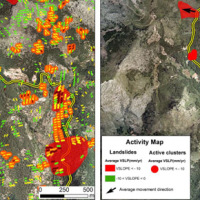
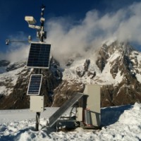
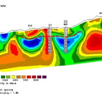
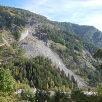 The Mont de La Saxe landslide affects the south-western side of Mont de La Saxe near Courmayeur, Valle d'Aosta. This landslide at present can be considered one of the most critical active landslides in the Italian Alps. The estimated unstable mass is more than eight millions of cubic meters and the main elements at risk are the hamlets of La Palud and Entreves, and the motorway access to the international tunnel of the Mont ...
 Topographic monitoring of the Costa Concordia vessel wreck
 Following the run aground off near the "Isola del Giglio" (Tuscany, Italy, January 13, 2012) of the cruise vessel "Costa Concordia", a monitoring system for handling the security of the SAR (Search and Rescue) operations and for the control of the ships' movements/deformations during the subsequent defueling and recovery phases has been progressively installed and ...
 Continuous monitoring of the seismogenic Paganica fault (AQ) after the April 6 2009 L’Aquila earthquake
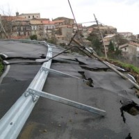
 The L’Aquila earthquake occurred the 6th April 2009, causing several casualties and damages to a large number of buildings and infrastructures. The event was a 6.3 moment magnitude (Mw). In the days following the earthquake, several aftershocks with Mw>4 affected the same general area. In total, within an area of about 50 km radius from L’Aquila town, the seismic sequence counted ca. 2×10⁴ events in about one year. Among the severely ...
 Triggering and evolution of the San Benedetto Ullano landslide
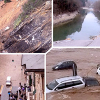
 With reference to landslides, Italy is exposed to high-risk conditions (Guzzetti, 2000). The abundant and prolonged rains fallen in the 2008-2009 and 2009-2010 wet seasons triggered numerous landslides in Calabria, mostly in its northernmost sector. Such geo-hydrological crises were severe enough to induce the Italian government to declare the State of Emergency on both ...
 Progetto Presídi
 Il progetto presidi soddisfa un’esigenza normativa (D.P.C.M. 27/02/2004) e conoscitiva della Protezione Civile Regionale del Piemonte; diventa uno strumento funzionale all’aggiornamento dei punti di criticità idrogeologica del territorio, individuati e verificati dopo una complessa indagine retrospettiva e lunga concertazione di diversi Enti territoriali competenti, e al loro monitoraggio durante le fasi parossistiche di eventi di piena o ...
 Prevention, Information and Early Warning pre-operational services to support the management of risks
 PREVIEW is an integrated project by the European Commission 6th Framework Programme, led by the EURORISK Consortium, a multi-disciplinary European Team of committing Actors of the domain: Civil Protections and Environmental Bodies; Scientific communities and Service operators, at national and regional level, for Meteorology, Hydrology, Seismology, Volcanology and GIS services based on Space data; and Industry. The project was organized around a ...