156 projects found

SOIL features and pedogenic processes as predisposing factors of SHAllow landsliDES
From 01/10/2023 to 28/02/2026
The project proposal aims at the assessment of the relationship between key soil properties (as result of peculiar weathering and pedogenic processes) and predisposing factors of shallow landslides, and the…
Flood pRediction In Small ungauged Basins of Italy through Enhanced runoff coefficient assEssment
From 28/09/2023 to 28/02/2026
The main objective of FRISBEE is to develop a reliable procedure for assessing the hydrological response of small basins throughout Italy to extreme rainfall events through the analysis and mapping…
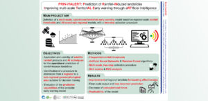
Prediction of Rainfall-INduced landslides – Improving multi-scale TerritoriAL Early warning through aRTificial intelligence
From 28/09/2023 to 27/09/2025
Project 202248MN7N_PE10_PRIN2022 – PNRR M4.C2.1.1 – Funded by European Union – Next Generation EU – CUP: B53D23006720006 Background Predicting the occurrence of rainfall-induced landslides is a crucial task for…
Application of climate change impact models on water supply systems in pilot basins of the Central Apennine District
Regional From 01/04/2023 to 31/03/2025
The ACQUACENTRO 2.1 project (Intervention Line L2 – Activity L2.1) aims to develop methodologies to analyze the potential impact of ongoing climate change on water supply systems located within the…

Responsive, Data ecosystem for Resilient and Operational SEcurity Strategies
European From 01/03/2023 to 28/02/2025
RED ROSES, Responsive Data Ecosystem for Resilient and Operational Security Strategies, is a project aimed at strengthening cross border cooperation between Italy and France in the management of natural hazards,…

Sentinel-3 Topography mission Assessment through Reference Techniques
Space agency From 27/07/2021 to 30/03/2023
Background The Copernicus Sentinel-3 Surface Topography Mission (STM) provides extremely valuable surface elevation information over inland waters, sea ice and land ice, thanks to its SAR altimeter which retrieves high-resolution…

National Centre for HPC, Big Data and Quantum Computing – Spoke 5
National From 01/09/2022 to 31/12/2025
Environmental degradation, the increase in natural disasters, and the relationship between these phenomena and climate change are among the scientific and social issues of greatest and growing global relevance. New…

mapping Site Effects at national and REgioNAl scale
From 01/05/2022 to 30/04/2025
The PRIN SERENA project, Mapping seismic site effects at regional and national scale, aims to develop a multidisciplinary and multiscale procedure for mapping seismic site effects in Italy. The objective…

Gestione delle Monografie Operative relative ai grandi fenomeni franosi inseriti nella rete di monitoraggio della regione autonoma Valle d’Aosta
Regional From 01/10/2021 to 31/12/2022
Background The Aosta Valley is a small alpine region affected by numerous landslides, varying in size and type, ranging from isolated rock falls to rotational/translational slides up to extensive deep…
Analisi di rischio di flusso della rete di monitoraggio delle frane della regione Lombardia
Regional From 03/06/2021 to 03/12/2022
Background Geological-geotechnical monitoring systems are one of the most effective tools for landslide characterization, both in terms of landslide detection and for monitoring purposes. The regional monitoring network of Regione…
Probabilistic floods and sediment transport forecasting in the Himalayas during the extreme events
Bilateral From 01/01/2022 to 31/12/2024
The project “Probabilistic floods and sediment transport forecasting in the Himalayas during extreme events (FLOSET)” is a research collaboration between Italian and Indian institutions funded under the Italy–India Joint Science…
Individual Change of HAbits Needed for Green European transition
From 01/11/2021 to 30/04/2025
Background The documented effects of climate change and environmental degradation are a threat to human societies on European and global scales. Climate change may have an impact on water availability,…
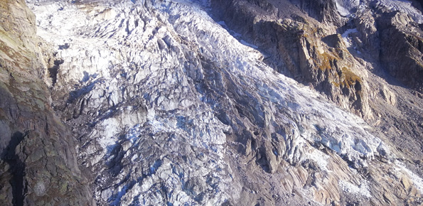
Laboratorio a Cielo aperto delle Grandes Jorasses per lo sviluppo di tecniche di monitoraggio di processi di instabilità in ambito glaciale
Regional From 10/10/2020 to 10/10/2023
Background Climate change has a powerful impact on high-altitude Alpine sectors and glaciers. This impact often turns into an increase in instability processes that can lead to very high-risk conditions.…

PRogetto IntegratO di mitigazione del RIschio da sprofondamento di caviTÀ
National From 16/01/2020
Purpose Il progetto intende formulare una metodologia innovativa, basata su un approccio multi-disciplinare, per una valutazione appropriata della suscettibilità al collasso di cavità artificiali in aree urbane del territorio italiano,…
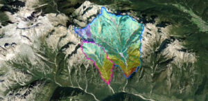
Assessing sediment connectivity and availability in several mountain catchments in the Veneto Region
European From 05/03/2020 to 31/03/2022
Background Mass wasting is a threat to residential areas and infrastructure, causing widespread destabilization in alpine stream channels, also in relation to ongoing climatic changes. Although hillslope sediment supply represents…