News

11th Asian Regional Conference: the IRPI CNR is contributing

CNR IRPI research scientists are contributing to the 11th Asian Regional Conference (ARC-11) of the International Association of Enginnering Geology and Environment (IAEG), held in Kathmandu, Nepal, from 28 to 30 November 2017. More than 400 participants from 30 countries contribute to the conference.
The conference was opened by the President of the Federal Democratic Republic of Nepal, Mrs. Bidhy Devi Bhandari.
More information on the conference is available here: http://iaegarc11ngs.com/
Before the conference, on 26 November, IRPI scientists participated as Italian representatives to the meeting of the Council of the International Association of Enginnering Geology and Environment (IAEG), also held in Kathmandu.

CNR IRPI at the China Italy Science, Technology & Innovation Week

It was officially opened today, in the presence of the Italian Minister of Education, University and Research Valeria Fedeli, his homologue Gang Wan, CNR President Massimo Inguscio and ASI President Roberto Battiston, the China Italy Science, Technology & Innovation Week.
Our Institute is present with the Moon Mapping Research Project (https://www.irpi.cnr.it/en/asi-asi-moon-mapping-project), which studies the topography and the composition of the lunar surface involving students from Italian and Chinese universities.

SAMSUNG CSC

The Italian team of the Moon Mapping project with the ASI President Battiston and some Chinese colleagues

SAMSUNG CSC

Sofia Fiorucci of the University of Perugia with Maria Teresa Brunetti, IRPI

At the end of the inauguration ceremony, the students gave to the two Ministers a copy of the map produced under the project.

news-china-italy-stiw-2017-1

The consign of the map to the Ministers

CNR IRPI attends the 6th International Forum on Opto-electronic Sensor-based Monitoring in Geo-engineering (6th OSMG-2017)

Luca Schenato from Padova Office of IRPI will give an invited talk at the plenary session of the 6th International Forum on Opto-electronic Sensor-based Monitoring in Geo-engineering (6th OSMG-2017) that will be held in Nanjing, China on 3-5 November 2017 (http://www.fosmg.com/). The forum theme of this edition is “Frontiers and Applications of Infrastructure Monitoring Technologies”, and Luca Schenato will present his activity about “Application of high-resolution OFDR-based distributed sensing to geotechnical problems: from a large scale physical model of a landslide to the monitoring of a foundation pile”.

Automated Inclinometer System: training course on “Study and monitoring activities”, Orvieto-Italy

Paolo Allasia and Giorgio Lollino of the Turin Section of the IRPI CNR, during a training course organized by the High School in the city of Orvieto have presented an innovative instrument developed and patented by IRPI CNR. The instrument allows robotically inclinometric measurements into the boreholes and is as an alternative approach to manual measurements and traditional in-place inclinometers. During the event, an instrumental demonstration was also carried out near of the famous Rupe di Orvieto.

https://www.irpi.cnr.it/focus/ais/

http://www.altascuola.org/news.php?id=news2

news-sistema-inclinometrico-automatizzato-orvieto-1
Demonstration of the system on the field (Rupe di Orvieto)

news-sistema-inclinometrico-automatizzato-orvieto-2

The IRPI CNR participate at the First Forum on: Rock Mechanics and Engineering Geology Forum on the Shaoxing University of China. The Rock Mechanical and Engineering Geological Problems for the Silk Road Economic Belt and 21st-Century Maritime Silk Road

Paolo Allasia and Giorgio Lollino of the Turin Section of IRPI CNR, were invited for a lecture at the University of Shaoxing during the first Rock Mechanics and Engineering Geology Forum. The symposium illustrated the main issues from a geological and engineering point of view of one of the most important and ambitious projects of the 21st century: the Belt and Road (B & R). The IRPI CNR illustrated how innovative monitoring techniques can mitigate the geo-hydrological issues related to this big infrastructure.

http://www.iaeg.info

http://www.sxfrg.org/

news-rock-mechanics-engineering-geology-forum-1
Paolo Allasia e Giorgio Lollino at the end of the lecture

news-rock-mechanics-engineering-geology-forum-2
Field trip at the Tianhuangping Pumped Storage Power Station

Fiber optic monitoring system on ‘Scientific Reports’

Luca Schenato and Alessandro Pasuto, from the IRPI Padova section, are co-authors of an article appeared in Scientific Reports (from the publishers of Nature) entitled “Distributed optical fiber detection for early detection of shallow landslides triggering”. The paper describes an experiment carried out on a physical model of a shallow landslide monitored with a distributed fiber optic strain system for the measurement of the strain field at the sliding surface. Source: www.nature.com/articles/s41598-017-12610-1

Nuovo articolo pubblicato dai ricercatori IRPI sulla tematica ‘Geo-hydrological risk perception’

Un nuovo lavoro, che vede tra i coautori i ricercatori dell’IRPI, Loredana Antronico e Roberto Coscarelli, è stato pubblicato sulla rivista International Journal of Disaster Risk Reduction: “Geo-hydrological risk perception: A case study in Calabria (Southern Italy)”.

La pubblicazione presenta i risultati di una indagine sulla percezione dei rischi naturali in un’area della Calabria interessata in un recente passato da eventi di dissesto geo-idrologico. Dall’indagine emerge che la popolazione, anche se con un elevato senso civico, non giudica positivamente l’operato degli Enti Locali, sia nell’ambito della gestione del territorio sia nell’ambito della formazione e dell’informazione della comunità. Inoltre, la popolazione, specie quella con un livello di formazione elevato, attribuisce, fra le cause dei fenomeni di dissesto idro-geologico, un ruolo rilevante all’azione antropica, fra cui l’abusivismo edilizio.

Vai all’articolo »


Editorial Board of PeerJ: two IRPI researchers joined

Two CNR IRPI researchers, Mauro Rossi and Marco Cavalli, have recently joined the Editorial Board of PeerJ (https://peerj.com/), a peer-review open access journal indexed in all major abstracting & indexing databases. PeerJ has recently expanded to explicitly include the Environmental Sciences and it is waiving all article processing charges (APCs) in the new subject areas for the next three months.

More details can be found here »

ASI TV: filmed at IRPI-CNR

Today, October 24, 2017, an ASI TV crew is hosted at our Institute’s headquarters for making a video clip on the activity carried out under the Moon Mapping project.

The video will be shown during the initial ceremony of the Innovation Forum scheduled for November 14, in Beijing (China), in the presence of the Italian Minister of Education Fedeli and his Chinese homologue Gang.


news-asi-tv-irpi-2017-0
news-asi-tv-irpi-2017-1
news-asi-tv-irpi-2017-2
news-asi-tv-irpi-2017-3

“Earthquake induced landslides” given by Hakan Tanyas

Questa mattina Hakan Tanyas (PhD @ ITC – The Netherlands) ospite presso la sede IRPI di Peurgia, ha tenuto una breve presentazione del suo lavoro inerente le frane sismo-indotte e loro modellazione basata sulle mappe di scuotimento, al fine di produrre un modello che possa contenere informazioni su diverse variabili geografiche, geologiche e sismologiche.

Un limite alla modellazione – che potrà basarsi su diverse unità cartografiche di riferimento – come ha spiegato Hakan, è posto dalla eterogeneità e qualità dei dati disponibili (inventari di frane e mappe di scuotimento).

Lo scopo della ricerca è fornire in tempi rapidi una valutazione dell’estensione dell’area potenzialmente interessata da frane indotte da eventi sismici, con conseguenze positive sulle operazioni di protezione civile.

news-earthquake-induced-landslides-2017-

IGU Commission on Hazard and Risk

Alessandro Mondini, Ricercatore IRPI, è membro della commissione IGU su Hazard and RISK. Il sito sui lavori della commissione è ora disponibile al seguente indirizzo,
http://oguchaylab.csis.u-tokyo.ac.jp/IGU_Hazard/index.html

New article published by an IRPI researcher on the Springer journal “Landslides”

New article published by an IRPI researcher on the Springer journal “Landslides”
Mauro Rossi, an IRPI researcher, is a co-author of a new paper published in “Landslides” (Impact Factor 3.6): “Reliability of water content estimation by profile probe and its effect on slope stability”.
The paper examines the calibration procedure of a probe (i.e. dielectric sensor) for measuring the soil water content and analyses its effects on the slope stability analysis. In shallow partially saturated soils, the use of inappropriate calibration equations may result in differences in soil water content estimate up to 10 percentage points, affecting the correct estimation of the suction stress and of the Factor of Safety.

Link to publication »

Partecipazione del CNR IRPI alla Notte dei Ricercatori

La sede di Padova del CNR IRPI ha partecipato il 29 settembre scorso alla Notte dei Ricercatori, evento organizzato a scala europea con lo scopo avvicinare la cittadinanza al mondo della ricerca.
In occasione della Notte dei Ricercatori, l’Area della Ricerca del CNR di Padova è stata aperta al pubblico per delle visite guidate ai laboratori, che hanno visto la partecipazione di circa 100 persone.
I ricercatori del CNR IRPI hanno sottolineato il contributo dei loro studi alla riduzione dei rischi geo-idrologici. Fra le attività presentate si segnalano la definizione di scenari di rischio per le grandi frane, il coinvolgimento della popolazione mediante iniziative di crowdsourcing in occasione di disastri naturali e l’interferometria da satellite.

news-padova_notte_ricercatori-2017

I tirocinanti dell’ITTS Alessandro Volta di Perugia, hanno presentato i risultati del lavoro svolto all’IRPI

Ormai è consolidato il gemellaggio tra l’IRPI e l’ITTS Alessandro Volta di Perugia: anche in questo avvio di anno scolastico gli studenti delle quarte e quinte hanno svolto un periodo di Alternanza Scuola Lavoro di quattro settimane presso la sede dell’IRPI di Perugia. I vari gruppi di lavoro coordinati dai ricercatori dell’Istituto, Ivan Marchesini e Mauro Rossi, hanno esposto oggi i risultati raggiunti in questo tirocinio.

I temi scelti, per il workshop mensile dei ragazzi, hanno riguardato ambiti IT di grande attualità per i settori di ricerca del Gruppo di Geomorfologia di Perugia: Analisi di dati meteo-climatici e geografici con restituzione di risultati aggregati e non in forma grafica anche 3D o 4D; Realtà virtuale aumentata per la visualizzazione della geologia del territorio; Utilizzo delle API di twitter per prelevare e geolocalizzare tweet che riguardano eventi connessi a dissesto idrogeologico al fine di creare un database ed analizzarne e mapparne i risultati; Rilevazione di dati sul territorio per mezzo di device mobili; Applicazione web per ottenere un elenco di punti sulla mappa in base alla ricerca di luoghi geologici; Utilizzo di servizi meteo nazionali o globali per interrogazione di reti meteo volontarie.

L’Istituto si appresta inoltre ad ospitare altri gruppi di studenti di altre scuole a partire dagli inizi del 2018.

(Alcuni scatti della giornata odierna: ragazzi al centro con insegnati e ricercatori ai lati)

news-itts-asl-2017-2

news-itts-asl-2017-3

news-itts-asl-2017-1

Mexico earthquake seen from space: Sentinel-1 radar images show how Mexico quake deformed the earth

Differential SAR interferometry (DInSAR) is a technique that allows to detect and measure deformations of the earth’s crust through the analysis of interferogram. Interferograms are generated from two images collected by radar transported on board of artificial satellites. Unlike other kind of sensor used in the remote sensing applications (e.g. optical cameras), radars allow to record the phase of the electromagnetic wave backscattered from the earth’s surface. Through the measurement of this phase, it is possible to reconstruct the target-sensor distance. The phase variations between successive acquisition, caused by mutations on the Earth’s surface, are recorded in the interferograms and represented by a series of fringes. These allow us to locate and quantify the deformation occured. DInSAR technique has been successfully applied to detect the effects on the earth’s surface due to subsidence, landslides, bradyseism, volcanic inflation-deflation cycles and telluric effects. Using two radar images collected by satellites Sentinel-1A/B of the European Space Agency we were able to quantify the deformations induced by the 7.1 magnitude earthquake that stroke Mexico on 19 September 2017.

The interferogram, generated from Sentinel-1A image collected the 17 of September, 2 days before the earthquake, and the acquisition the twin mission Sentinel-1B, post-event, 6 days later, shows clear concentric fringes in the area surrounding the epicenter (Figure 1).

(Figure 1: Interferometric fringes caused by the M 7.1 earthquake that stroke Mexico on 19 September 2017)

news-mantovani-terremoto-messico-2017-1

The phase information was converted in terms of displacement in Figure 2, which reproduces the earthquake effect on the earth surface. The first estimates indicate a crust subsidence (in red) of about 5 cm over an area of more than 1,000 square kilometers. At the margin of this region, two uplifting area (in blue) can be recognized, the most evident located south of the Cuernavaca city, west of the epicenter.

(Figure 2: Displacement map elaborated from the interferogram. Red areas represent the regions where the crust lowered, while the blue ones indicate a surface uplift. Green areas have not undergone variations.)

news-mantovani-terremoto-messico-2017-2

The work was carried out by Matteo Mantovani, IRPI CNR researcher at the Padua office.

2017 SMART RIVER AWARD assegnato al lavoro ‘Levee body vulnerability to seepage and impact of animal burrows’

Nell’ambito della Conferenza Internazionale REMTECH ESONDA EXPO (20-22 Settembre 2017, Ferrara, http://www.remtechexpo.com/it/esonda/smart-rivers-awards) sono stati assegnati gli Smart Rivers UNESCO Alta Scuola Rem Tech Awards. Il premio come Best Paper – categoria A è stato attribuito al contributo ‘Levee body vulnerability to seepage and impact of animal burrows’ di Michela Rosa Palladino, Silvia Barbetta, Stefania Camici, Pierluigi Claps e Tommaso Moramarco. Il lavoro descrive in sintesi l’attività svolta da M. R. Palladino nell’ambito del lavoro di tesi di dottorato in Ingegneria Ambientale (Politecnico di Torino, CICLO XXIX) svolto in stretta collaborazione con l’IRPI-CNR di Perugia (Tutors: Pierluigi Claps e Silvia Barbetta).

Luca Schenato, from the Padova branch of IRPI, has been recognized as one of the 2017 outstanding reviewers by Optical Society of America

“The Outstanding Reviewer program is one way that OSA is able to express its appreciation to those who have worked so conscientiously and tirelessly on behalf of our journals. OSA congratulates the 2017 class of Outstanding Reviewers for their well-deserved recognition and thanks the thousands of other volunteers worldwide who continuously participate in our rigorous peer-review process.” [Elizabeth Nolan, Deputy Executive Director of The Optical Society and Chief Publishing Officer].

Link »

IRPI is in the INDECIS project funded by EC

IRPI is one of the Principal Investigators of the project “INDECIS – INtegrated approach for the DEvelopment across Europe of user oriented Climate Indicators for GFCS high-priority Sectors: agriculture, disaster risk reduction, energy, health, water and tourism”, funded by EC by means the the “ERA4CS Joint Call  – Topic B: Researching and Advancing Climate Service Development by Institutional Integration”.

The INDECIS project will develop an integrated approach to produce a set of relevant climate indices targeting the high priority sectors of the World Meteorological Organization’s Global Framework for Climate Services (agriculture, disaster risk reduction, energy, health, water) plus tourism. Moreover, models and tools will be developed for  near-real time calculation, spatial interpolation, visualization and communication of climate monitoring.

With these aims, the INDECIS project will inventory and catalog existing datasets of precipitation, temperature, wind speed and sunshine duration. New methods and tools will be developed to operationally assure the quality and homogeneity of data sets. In parallel, information on climate indicators will be gathered and works to improve them in consultation with the stakeholdes will be carried out.

The staff of the INDECIS project, coordinated by Enric Aguillar of the University Rovira I Virgili/Center for Climate Change (C3) – Spain,  is composed by: University of Reading (UK), Finnish Meteorological Institute (FIN), BRGM/Water Division (F), CNR – IRPI (I), Universidad de Cantabria / Environmental Hydraulics Institute (E), Swedish Meteorological and Hydrological Institute (S), Department of the Environment, Community and Local Government (IRL), Agencia Estatal de Meteorología (E), Barcelona Supercomputer Center (BSC)/Earth Sciences Department (E), FCiencias.ID – Associacao para a Investigacao e Desenvolvimento de Ciencias (P), Global Change Research Institute – Czech Academy of Sciences (CZ), Royal Netherlands Meteorological Institute (NL), Royal Meteorological Institute of Belgium – Meteorological and Climatological Research  (B), National Meteorological Administration (RO), Instituto Pirenaico de Ecología/Consejo Superior de Investigaciones Científicas (E).

The CNR Unit of the project is coordinated by Roberto Coscarelli (IRPI – office of Cosenza).

The start of the project, that has a 3-year duration, is fixed in 15/09/2017.

Per informazioni: r.coscarelli@irpi.cnr.it

Link to the project web page »

Firmato il Memorandum of Understanding tra l’IRPI e l’Indian Institute of Technology di Roorkee per collaborazioni sui rischi naturali

L’Istituto di Ricerca per la Protezione Idrogeologica e l’Indian Institute of Technology di Roorkee hanno firmato un Protocollo di Intesa per promuovere una collaborazione scientifica nel campo dei Rischi Naturali. In particolare, oltre alla mobilità di ricercatori di ciascuna istituzione e l’organizzazione congiunta di corsi, workshop e conferenze, il Protocollo prevede lo sviluppo sinergico di attività di ricerca che mirano all’avanzamento delle conoscenze nei processi di base dei fenomeni dei rischi naturali in un contesto di cambiamenti globali. In tale ambito, è previsto lo scambio di informazioni, risorse e competenze riguardanti attività in materia di monitoraggio idrometeorologico (al suolo e da satellite), piene improvvise e fenomeni alluvionali, siccità, frane, acque sotterranee, fusione dei ghiacciai, cambiamenti climatici, ricerca e innovazione tecnologica.

Drought: Irpi Cnr examines soil moisture

Italy is currently experiencing dramatic drought conditions, caused by low rainfall (rainfall totals in the first half of 2017 80% below normal in several parts of Italy) and exceptionally high temperatures for most of 2017. In southern Italy the drought has led to abundant wildfires causing economic damages and losses of forests. Recently, because of ongoing water scarcity and yield losses, half of the Italian regions are going for asking the natural disaster status. For example, Rome is at risk of drastic water rationing while Coldiretti estimated €2bn worth of damage had been done to Italian agriculture so far.
A brand-new, long-term and globally available satellite soil moisture dataset now allows the Research Institute for Geo-Hydrological Protection of National Research Council (Irpi-Cnr) to closely monitor and predict the impact of the current drought situation. This near-real-time product is produced as part of the Copernicus Climate Changes Service (C3S) portfolio of the European Commission. Irpi-Cnr has been involved in its pre-operational development and assessment.

What do we see in the plots?
The new satellite dataset shows that during the last 10 days (Figure 1) in Italy the soils are much drier than usual. Nowhere else in Europe current soil moisture conditions are as abnormally low as in central Italy. However, also other parts of southern Europe suffer from severe drought, such as France and the Balkans. Like in Italy, these regions have been severely struck by forest fires during the last few weeks. At the same time, large parts of Germany and Poland and also the Bosporus have recently suffered torrential rainfall and floods. This is reflected by the wetter than usual conditions in the image.

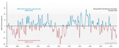
The new satellite dataset also allows to look at past soil moisture conditions (Figure 2). Soil moisture data from Southern Tuscany (Grosseto province) show that the soil has already been drier than normal since December 2016. Even though drier than normal conditions occur regularly, the current situation stands out for its intensity and persistence, similar as in the well-known drought years 2007 and 2012.

More details about the C3S satellite soil moisture product
The C3S soil moisture product is based on satellite measurements of microwaves that are either reflected or emitted by the Earth surface. The intensity of the measured signal strongly depends on the amount of water in the soil. The Vienna University of Technology (TU Wien) and the Dutch company VanderSat B.V. have developed methods to convert these measurements into estimates of soil moisture. With the support of various European partners, including Irpi-Cnr, they produced a long-term (1978-present) dataset in the context of the Climate Change Initiative of the European Space Agency (ESA). Within C3S, the Vienna-based Earth Observation Data Centre (EODC) updates this dataset every 10 days with the latest observations. The C3S data will be officially accessible through the European Centre for Medium-range Weather Forecasts (ECMWF) from January 2018 at http://climate.copernicus.eu/ but can already now be visually explored at http://rs.geo.tuwien.ac.at/data_viewer/c3s/.

How Irpi-Cnr uses C3S satellite soil moisture in their studies
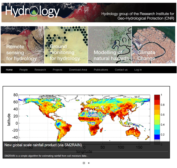
Irpi-Cnr is using the long-term C3S satellite soil moisture dataset for several hydrological applications in several regions of the world. For instance, Irpi-Cnr will use this dataset to develop a drought monitoring system in India. On the other hand, Irpi-Cnr  also uses the dataset to improve flood and landslide forecasts. IRPI-CNR will also use this dataset to estimate rainfall on a global scale (https://www.irpi.cnr.it/en/focus/sm2rain/), with projects funded by space agencies and by the Italian Department of Civil Protection. Specifically, the near-real-time availability of the dataset will allow IRPI-CNR to better monitor and make better predictions of natural hazards.

Conclusions
The drought conditions in Italy are expected to aggravate even more because no significant rain and continuing high temperatures are expected for the coming weeks. The satellite soil moisture dataset will be continuously used for monitoring drought conditions throughout the Italian territory and can support local and national authorities facing water scarcity.

Per informazioni:
Luca Brocca
luca.brocca@irpi.cnr.it
https://www.irpi.cnr.it/, http://hydrology.irpi.cnr.it/

Wouter Dorigo
Research Group Climate and Environmental Remote Sensing, Vienna University of Technology (TU Wien)
wouter.dorigo@tuwien.ac.at
http://climers.geo.tuwien.ac.at
Immagini:

SoilMoistureAnomaly
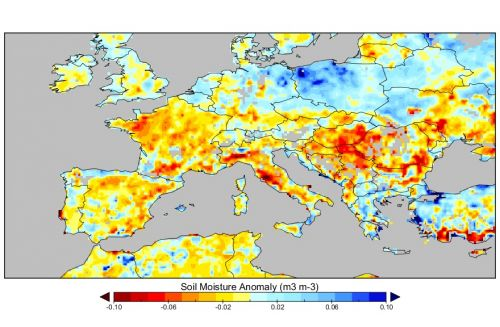
Deviations in soil moisture from conditions that are normally found in Mid-July

Anomaly

Soil moisture deviations from normal conditions over the last 10 years for the Grosseto province, Tuscany

An article of CNR IRPI among the most cited

According to the Geomorphology journal’s website, the article “Cavalli, M., Trevisani, S., Comiti, F., Marchi, L., 2013. Geomorphometric assessment of spatial sediment connectivity in small Alpine catchments. Geomorphology, 188, 31-41, doi: 10.1016 / j.geomorph.2012.05.007 “is, to date, among the 10 articles published since 2012 which have received the highest number of citations. Two of the authors (Marco Cavalli and Lorenzo Marchi) are researchers at the Research Institute for Geo-Hydrological Protection.
https://www.journals.elsevier.com/geomorphology/most-cited-articles

New paper published by IRPI researcher on High Impact journal Reviews on Geophysics (IF 12.3)

Luca Brocca, researcher of IRPI-CNR, is coauthor of a paper published on the High Impact journal Reviews on Geophysics (IF 12.3): “Validation practices for satellite based earth observation data across communities”.
The paper reviews state-of-the-art methods of satellite validation across different scientific communities and documents their similarities and differences. First the overall validation objectives and terminologies are specified, followed by a generic mathematical formulation of the validation problem. An outlook on the applicability and requirements of current Earth Observation validation approaches and targets is given.
The paper would serve as a reference for the future studies addressed to the validation of satellite observations.

Link:
http://onlinelibrary.wiley.com/doi/10.1002/2017RG000562/abstract

Tra le top 25 una pubblicazione firmata IRPI

L’articolo “Statistical approaches for the definition of landslide rainfall thresholds and their uncertainty using rain gauge and satellite data” – ( Rossi, M., Luciani, S., Valigi, D., Kirschbaum, D., Brunetti, M. T., Peruccacci, S., & Guzzetti, F. (2017). Statistical approaches for the definition of landslide rainfall thresholds and their uncertainty using rain gauge and satellite data. Geomorphology, 285, 16-27. https://doi.org/10.1016/j.geomorph.2017.02.001) – pubblicato dalla rivista Geomorphology è, ad oggi, tra i 25 più scaricati della rivista. La pubblicazione ha tra i vari autori alcuni ricercatori dell’Istituto di Ricerca per la Protezione Idrogeologica: Mauro Rossi, Maria Teresa Brunetti, Silvia Peruccacci e Fausto Guzzetti (Direttore).

 Most Downloaded Geomorphology Articles »

10th Japan-Italy joint workshop on sediment disaster prevention

The 10th edition of the Japan-Italy joint workshop on sediment disaster prevention”, will be held in Tokyo, Japan, from 12 to 16 June 2017, and will be jointly organised by the Ministry of Land, Infrastructure, Transport and Tourism and our Institute (MLITT). The workshop will be attended by CNR IRPI research scientists from Perugia and Padua. During the workshop, our scientists will deliver a number of talk at the MLITT headquarters in Tokyo, and at the National Institute for Land and Infrastructure Management (NILIM) in Tsukuba.

Picture: Friendly dinner after field investigation in Kumamoto area affected by a M. 7.3 earthquake in 2016

news-workshop-japan-italy-2017-2

MEDSCOPE project: the IRPI contribution

IRPI participates in the project “MEDSCOPE – Mediterranean Services Chain Based on Climate PrEdictions, funded through the ERA4CS Joint Call  – Topic B: Researching and Advancing Climate Service Development by Institutional integration.

The project aims to develop climate forecast capabilities and related services on seasonal-to-decadal timescales. The strategy will be based on exploiting the wide range of existing datasets of climate observations and forecasts to improve our understanding of sources and mechanisms of predictability.

The added value provided by MEDSCOPE to climate services will be assessed for various sectors with high societal impact, e.g. renewable energy, hydrology and agriculture and forestry. The IRPI contribution will cover this aspect of the project, with particular reference to the conditions and evolution of cryosphere resources (Task 4.2).

The MEDSCOPE project is coordinated by Silvio Gualdi of the CMCC Foundation, and the other partners are: CNR (P.I. Susanna Corti, ISAC), RMI, BSC, AEMET, Météo France, INRA.

For IRPI, Marta Chiarle, Guido Nigrelli and Giovanni Mortara, of the GeoClimAlp Research Group participate.

The start of the project is scheduled for summer 2017, for a duration of three years.

For information: marta.chiarle@irpi.cnr.it

http://www.jpi-climate.eu/nl/25223458-MEDSCOPE.html

http://geoclimalp.irpi.cnr.it/index.php/it/

Conclusione dello stage dei studenti dell’ITT di Catiglione del Lago

Dopo due settimane di stage, si è conclusa oggi, con una presentazione del lavoro svolto, l’esperienza di quattro studenti – del terzo anno dell’ITT di Castiglione del Lago (Perugia) – presso l’Istituto di Ricerca per la Protezione Idrogeologica di Perugia. I quattro ragazzi sollecitati dai loro professori e con il supporto dei ricercatori dell’IRPI hanno approfondito le loro conoscenze in materia di informatica ed elettronica mediante lo studio della famosa piattaforma hardware Arduino. Durante il loro stage hanno implementato dei prototipi di soluzioni di misurazione di grandezze fisiche ambientali di interesse idrogeologico – quali umidità, temperatura e distanza – e la loro archiviazione in database. Questo primo step fa parte di un programma più ampio che probabilmente vedrà i studenti coinvolti, con l’inizio del nuovo anno scolastico, in un progetto di realizzazione di una stazione meteo. Progetto che potrebbe avere una ricaduta pratica negli ambiti d’interesse dell’Istituto.

Foto dei studenti stagisti, da sinistra: Matteo Violi, Filippo Broccolini, Lorenzo Mencaroni, Lorenzo Bianciardi

news-stage-itt-castiglione-maggio-2017


Memex – Luoghi della scienza sbarca in Umbria

Tra i protagonisti del programma in onda su Rai Scuola anche i ricercatori del CNR-IRPI di Perugia.

La puntata “Umbria – Un viaggio alla scoperta dell’Italia della ricerca e della sperimentazione scientifica” verrà trasmessa martedì 6 giugno alle 21.30. Federica Fiorucci e Christian Massari spiegheranno al pubblico alcune fra le tematiche di ricerca affrontate dai ricercatori dell’Istituto.

In particolare verranno illustrate le attività per l’identificazione e la mappatura dei movimenti franosi svolte presso il laboratorio di foto interpretazione e le attività connesse al monitoraggio e previsione delle inondazioni.

Rai Scuola è visibile sul canale 146 del digitale terrestre, sul canale 33 di Tivùsat, sul canale 806 della piattaforma satellitare Sky e su www.raiscuola.rai.it

Landslide Risk Reduction: CNR IRPI has been appointed as World Centre of Excellence

CNR IRPI has been appointed as World Centre of Excellence on Landslide Risk Reduction (WCoEs)  by the International Consortium on Landslides (ICL), for the years 2017-2020, in regard to the theme “Methods and tools for landslide forecasting and risk mitigation and adaptation strategies”. The nominations follows the proposal presented by CNR IRPI last year, which, after a technical evaluation by an ICL Committee, and the endorsement by an Indipendent Panel of Experts, was supported by the Assistant Director-General for Natural Science of UNESCO. Yesterday, within the framework of the activities of the first day of the 4th World Landslide Forum, at Ljubljana (Slovenia), CNR IRPI was officially recognized WCoEs 2017-2020.


Photo: Mario Parise, on the behalf of the CNR IRPI Director, Fausto Guzzetti, is awarded by Qunli Han, Director of UNESCO Ecological and Earth Sciences.

news-Wlf4_2017_Ljubljana-parise
news-Wlf4_2017_Ljubljana-parise-group
news-certificato-IPL-4th-world-landslide-forum-Ljubljana-2017

Luca Schenato to the Seventh Meeting of the 418th Academic Year of the Galilean Academy

On Friday May 19, 2017, Luca Schenato, Researcher at Padova’s IRPI office, has been invited to attend the Seventh Meeting of the 418th Academic Year of the Galilean Academy of Sciences, Arts and Sciences, to present a talk entitled “Fiber Optic Sensors for Geo-hydrological Risks”.

The Galileiana Academy of Arts and Science, formerly Patavina Academy, heir of the ancient Accademia dei Ricovrati, was founded on the 25th of November 1599. It promotes an interdisciplinary research and cultural promotion activity carried out by the 200 members, eminent scholars of every branch of knowledge. Along with the traditional public meetings, it also promotes scientific conferences, symposia, study seminars that are the result of original and unpublished research.

The program of the meeting is here attached and further information can be found at http://www.accademiagalileiana.it/.

Dal gruppo di idrologia di Perugia l’articolo premiato come EWRI Best Case Study

L’articolo “Assessment of the Drought Hazard in the Tiber River Basin in Central Italy and a Comparison of New and Commonly Used Meteorological Indicators”, pubblicato nel 2015 su Journal of Hydrologic Engineering (ASCE) 20(8) (doi:10.1061/(ASCE)HE.1943-5584.0001094), è stato premiato come EWRI Best Case Study. Tra gli autori della pubblicazione Pamela Maccioni, Luca Brocca e Tommaso Moramarco del gruppo di Idrologia presso l’IRPI CNR di Perugia. La premiazione avverrà durante il World Environmental & Water Resources Congress al Sacramento Convention Center il prossimo 21-25 maggio.

Maggiori informazioni presso il sito web dell’evento »

Programma dell’evento »


La Società Idrologica Italiana (SII) bandisce il “Premio Florisa Melone” per la ricerca nel campo delle scienze idrologiche sul tema della “Innovazione nel Monitoraggio Idrologico e Idraulico”

Il Premio vuole essere un tributo alla memoria della dottoressa Melone, ricercatrice dell’Istituto di ricerca per la protezione idrogeologica e già socia della Società Idrologica Italiana, prematuramente scomparsa nel 2012. Nel corso della sua attività, la dottoressa ha svolto importanti e innovative ricerche nell’ambito dell’idrologia, spaziando dal monitoraggio dei bacini idrografici allo studio dei processi, dalla previsione delle piene al rischio alluvioni in un contesto di cambiamenti climatici.

Il premio, oltre a ricordare le elevate qualità scientifiche e morali della dottoressa, nasce con la finalità di incoraggiare l’autonomia di ricerca dei giovani iscritti alla Società Idrologica Italiana e stimolare nuove idee nel campo idrologico. Il premio, finanziato della famiglia della dottoressa Melone, assegna un supporto economico di 5000 euro a progetti di ricerca svolti da ricercatori che abbiano un’età̀ inferiore a 35 anni e abbiano conseguito il Dottorato di Ricerca.

Dettagli sulle modalità di partecipazione alla Call 2017 del premio con scadenza 15 giugno sono disponibili al link: http://www.sii-ihs.it/news.php?open=49&pb=home

Il CNR IRPI partecipa al progetto SicuraMente

“SicuraMente” è un progetto sperimentale di educazione e orientamento alla cultura della protezione civile, della sicurezza e dell’autoprotezione dai rischi. Il Progetto è finanziato dalla Presidenza del Consiglio dei Ministri – Dipartimento della Protezione Civile, patrocinato da enti di ricerca nazionali (tra i quali il CNR IRPI), e si inserisce tra le attività di interesse per la formazione dei cittadini. I destinatari del progetto SicuraMente sono proprio gli studenti universitari e delle Scuole secondarie di secondo grado ai quali si propone un percorso formativo che gli consenta, oltre che migliorare la propria conoscenza del territorio e dei suoi rischi, di accrescere in loro percezioni, motivazioni, conoscenze e competenze.

Presentazione SicuraMente >>

Locandina SicuraMente >>

Invito SicuraMente >>

I ragazzi dell’ITTS hanno presentato i risultati della collaborazione con l’IRPI

Si è svolta nella mattinata di oggi 14 aprile 2017, nella sala convegni dell’Istituto di Ricerca per la Protezione Idrogeologica (sede di Perugia), la presentazione dei lavori svolti dai ragazzi dell’ITTS Alessandro Volta di Perugia. I ragazzi del quarto e quinto superiore ad indirizzo informatico, coordinati dai loro professori ed alcuni ricercatori dell’IRPI,  hanno portato avanti una collaborazione con l’Istituto in vari momenti dell’anno scolastico. Una collaborazione che per la verità è ormai consolidata già da anni. I lavori hanno riguardato lo sviluppo di piattaforme web per la geolocalizzazione di fenomeni franosi e di archivi di pubblicazioni scientifiche e l’implementazione di realtà 3D per la simulazione di frane.

Alcuni scatti della mattinata.

news-itis-irpi-presentazione-2017-1-small news-itis-irpi-presentazione-2017-2-small news-itis-irpi-presentazione-2017-3-small


Premiata Giulia Bossi dal Consiglio Direttivo della IAEG

Il Consiglio Direttivo della Sezione italiana dell’International Association of Engineering Geology, presediuto dal prof. G.B. Crosta, ha premiato Giulia Bossi, assegnista della sede di Padova, per la tesi di dottorato “Statistical analysis of the error associated with the simplification of the stratigraphy in geotechnical models“. La tesi, sviluppata in collaborazione tra CNR-IRPI e Università degli Studi di Bologna, Alma Mater Studiorum, Dipartimento di Ingegneria Civile, Ambientale e dei Materiali, ha come oggetto l’influenza delle eterogeneità del terreno nella dinamica di versanti instabili. E’ stato sviluppato un algoritmo che permette di valutare la variabilità dei risultati per modelli bidimensionali e tridimensionali, l’algoritmo consente inoltre di calibrare automaticamente modelli di frane in back-analysis e identificare le aree in cui procedere per una seconda fase d’indagine per ridurre maggiormente l’incertezza globale del modello di stabilità del pendio.

I due vincitori  del premio usufruiranno di un rimborso delle spese di iscrizione relative al prossimo convegno internazionale della IAEG.

The Research Institute for Geo-Hydrological Protection is in one of the 8 Research Project funded by means of the “European ERA4CS Joint Call for Transnational Collaborative”

The Research Institute for Geo-Hydrological Protection is in one of the 8 Research Project funded by means of the “European ERA4CS Joint Call for Transnational Collaborative – Topic B: Researching and Advancing Climate Service Development by Institutional integration”. The funded project is “INDECIS  – Integrated approach for the development across Europe of user oriented climate indicators for GFCS high-priority sectors: agriculture, disaster risk reduction, energy, health, water and tourism”. It is coordinated by Enric Aguillar of the University Rovira I Virgili (Center for Climate Change, C3) – Spain – and member of the WMO  Executive Council Panel of Experts on Education and Training.

One of the aims of the project is the production of a set regarding relevant climate indices targeting the high priority sectors of the World Meteorological Organization’s Global Framework for Climate Services. INDECIS will inventory and catalog existing datasets of precipitation, temperature, wind speed and sunshine duration. It will search new data holdings and will develop new methods and tools to operationally assure their quality and homogeneity. It is also intended to use sectorial statistics and teleconnection indices to explore predictive relations and responses to climate variability and change.

Roberto Coscarelli, Researcher of the IRPI Cosenza office, is one of the INDECIS Principal Investigators coming from 12 European Countries.

Link to ERA4CS: http://www.jpi-climate.eu/ERA4CS

Seminari sul tema ‘modelli a rete neurale’ all’IRPI di Perugia

Oggi 30 marzo 2017 l’Istituto di Ricerca per la Protezione Idrogeologica – sede di Perugia – ospita due ricercatori Antonello Pasini e Stefano Amendola rispettivamente afferenti all’Istituto sull’Inquinamento Atmosferico di Roma e al Dipartimento di Matematica e Fisica dell’Università di Roma Tre.

I due studiosi, tratteranno due interessanti argomenti dal titolo “Modelli a rete neurale per applicazioni climatiche e di impatto” e “Un modello a rete neurale per il downscaling statistico delle previsioni stagionali”. Considerando il notevole interesse dell’IRPI alla ricerca in ambito di clima e previsioni climatiche, questo incontro potrebbe aprire nuovi ambiti di studio e di collaborazione.

IRPI Hydrology now online

The group of Hydrology publishes online the new website, with improved graphics and rich information contents. The website contains presentations and descriptions of the latest and advanced research in which the group is involved. The internal links allow the curious to explore research topics and to find exhaustive explanations to their questions. Finally, codes and datasets are freely available and constantly updated.

Link to the new web site » 

news-idrologia-marzo-2017

Terremoto e altri rischi naturali: la scienza per un futuro migliore

La ricerca al servizio di cittadini e istituzioni. Venerdì 10 marzo 2017 a Foligno

I ricercatori del CNR incontrano oggi i cittadini e le istituzioni della città di Foligno in un incontro dibattito sul tema dei rischi naturali. Terremoti, ma anche frane e inondazioni, sono fenomeni naturali frequenti in Umbria, comprendere le dinamiche e come queste interferiscano con la vita quotidiana di tutti noi è diventata una necessità inderogabile. La conoscenza dei possibili rischi a cui siamo soggetti è di estrema importanza per affrontarli con maggiore efficacia e consapevolezza. Questo il tema dell’incontro. I ricercatori del CNR parleranno delle conoscenze acquisite e delle ricerche in corso e illustreranno le attività che gli istituti stanno conducendo in supporto all’attuale emergenza terremoto.

Interverrà il presidente del CNR Massimo Inguscio, il direttore dell’Istituto di ricerca per la protezione idrogeologica Fausto Guzzetti, il direttore dell’istituto di geologia ambientale e di geoingegneria Paola Messina, il direttore dell’Istituto per le Tecnologie della Costruzione Antonio Occhiuzzi, e il direttore dell’Istituto per le Tecnologie Applicate ai Beni Culturali Paolo Mauriello.

Programma

Giulia Bossi alla presentazione del libro “100 Donne contro gli stereotipi”

L’8 Marzo si è tenuto a Milano, alla Fondazione Bracco, la presentazione del libro “100 Donne contro gli stereotipi”. All’evento hanno partecipato 100 scienziate italiane, ricercatrici in materie Science, Technology, Engineering and Mathematics (STEM), selezionate per confluire in un database a disposizione dei giornalisti per essere interpellate in qualità di esperte. Il database è accessibile online all’indirizzo 100esperte.it.

Tra le 100 esperte c’è Giulia Bossi, assegnista presso l’IRPI CNR della sede secondaria di Padova, che ha partecipato all’incontro.

Maggiori informazioni dal comunicato stampa »

Twitter – post dell’evento » 

Foto from Twitter by “Fondazione Bracco”

news-giulia-bossi-mar2017

Global scale irrigation assessment through SM2RAIN

On February 1st, 2017, IRPI-CNR started a new project funded by the European Space Agency entitled “WACMOS-Irrigation”. The main purpose of the project is the investigation of the potential of satellite soil moisture data for estimating irrigation on a global scale, by exploiting the SM2RAIN algorithm developed by IRPI-CNR.

news-brocca-esa-2017

Piernicola Lollino nuovo responsabile della sede IRPI CNR di Bari

Da oggi il nuovo responsabile della Sede secondaria IRPI CNR di Bari è l’Ing. Piernicola Lollino, che prende il posto del Dott. Mario Parise il quale, dopo anni di servizio come ricercatore presso il CNR, lascerà l’Istituto di Ricerca per la Protezione Idrogeologica per dedicarsi a tempo pieno all’insegnamento universitario.

Ricercatori italiani dell’IRPI nel team internazionale di ricerca per la riduzione del rischio da frana in India

Al via i lavori del progetto LANDSLIP – LANDSLIde multi-hazard assessment, Preparedness and early warning in south Asia. La cerimonia di apertura si terrà oggi 20 gennaio presso il Vivekananda International Foundation di Nuova Delhi. Il team internazionale collaborerà per migliorare i sistemi di previsione e monitoraggio dei movimenti franosi con l’obiettivo comune di ridurne l’impatto sulla popolazione, sostenere l’economia e migliorare la resilienza delle comunità in India.

Le frane in India sono causa di un alto numero di vittime, producono cospicue perdite a proprietà e consistenti danni a infrastrutture e servizi. I movimenti franosi sono infatti molto frequenti nelle aree montuose di questo paese e hanno un forte impatto sulle città, densamente popolate, lungo le principali arterie di collegamento e coinvolgono spesso siti Unesco patrimonio dell’umanità.

A causa della complessità delle condizioni ambientali, geologiche e geomorfologiche che controllano i movimenti franosi e la loro variabilità spaziale e temporale, le frane sono fenomeni intrinsecamente difficili da prevedere e gestire. I ricercatori inglesi, italiani e indiani lavoreranno insieme per sviluppare adeguati e innovativi sistemi di gestione del rischio e previsione dei movimenti franosi testando le loro ricerche in due aree di studio: nel Darjeeling, ai bordi della catena Himalaiana, e nel distretto del Nilgiris, nella parte meridionale dell’India nella catena dei monti Ghats.

Il consorzio del progetto LANDSLIP è composto da 36 ricercatori di differenti istituzioni inglesi, italiane e indiane. Per l’Italia sono coinvolti ricercatori dell’Istituto di ricerca per la protezione idrogeologica (IRPI) del Cnr che collaboreranno al progetto quadriennale con i colleghi inglesi del British Geological Survey (BGS), del King’s College London (KCL), della Newcastle University, e del UK Met Office. Per l’India sono coinvolti i geologi del Geological Survey of India (GSI). Il progetto rientra nell’ambito del programma internazionale SHEAR – Science for Humanitarian Emergencies And Resilience – finanziato dal governo inglese, dal NERC (Natural Environment Research Council) e dall’ESRC (Economic & Social Research Council), con l’obiettivo di sostenere e migliorare la resilienza ai disastri naturali, la risposta umanitaria tramite avanzati sistemi di monitoraggio, previsione e gestione dei rischi naturali nei paesi dell’Africa Sub-Sahariana e in quelli dell’Asia meridionale.

news-landslip-2017

Fausto Guzzetti nella Struttura per la ricostruzione nei territori interessati dal sisma di agosto 2016

Il direttore dell’IRPI, dottor Fausto Guzzetti, è stato nominato membro del Comitato Tecnico-Scientifico della Struttura del Commissario straordinario del Governo per la ricostruzione nei territori dei Comuni delle Regioni di Abruzzo, Lazio, Marche ed Umbria interessati dall’evento sismico del 24 agosto 2016. Il Comitato, istituito dal Commissario Vasco Errani con l’Ordinanza n. 11 del 9 gennaio 2017, ha il compito di definire i criteri di indirizzo per la pianificazione, la progettazione e la realizzazione degli interventi di ricostruzione con adeguamento sismico degli edifici distrutti e di ripristino con miglioramento sismico degli edifici danneggiati. Tali criteri dovranno garantire la compatibilità degli interventi con la tutela degli aspetti architettonici, storici e ambientali, anche mediante specifiche indicazioni dirette ad assicurare una architettura ecosostenibile e l’efficientamento energetico.

Centro Storico di Amatrice

Centro Storico di Amatrice

  (Foto di Federica Fiorucci)

Tommaso Moramarco is the new president of Società Idrologica Italiana

Since January 1, 2017, Tommaso Moramarco, senior researcher with IRPI CNR, is the new president of the Società Idrologica Italiana (SII). SII (http://www.sii-ihs.it/) aims to enable progress, enhancement and dissemination of Hydrological Sciences promoting the coordination and multidisciplinary collaboration in research aimed at qualitative and quantitative description of all components of the hydrological cycle processes. In particular, important themes are the flood forecasting, the natural hazards assessment and mitigation of extreme hydrological events along with the water resource management even in a climate change context. For this reason, SII fosters the tight cooperation among Research Institutions (like CNR and University), Ministries, Public Authorities and Private Consultants.

Rapporto Periodico sul Rischio posto alla Popolazione italiana da Frane e Inondazioni – Anno 2016

È disponibile nel sito Polaris il Rapporto Periodico sul Rischio posto alla Popolazione italiana da Frane e Inondazioni – Anno 2016.
Fra il 1° gennaio e il 31 dicembre 2016 in Italia le frane e le inondazioni hanno causato 4 morti, 3 dispersi e 12 feriti. Più in particolare, a causa delle frane una persona ha perso la vita e 12 sono rimaste ferite, mentre le inondazioni hanno causato 3 morti e 3 dispersi. Le persone che hanno dovuto abbandonare temporaneamente le proprie abitazioni a causa di tali eventi sono state oltre 8.900, di cui la maggior parte dovute alle inondazioni del novembre 2016 che hanno interessato il Piemonte e la Liguria. Nei dodici mesi considerati dal rapporto, frane e inondazioni hanno prodotto danni alla popolazione (morti, dispesi, feriti sfollati e senzatetto) in 69 comuni di 19 regioni. Il Rapporto Periodico contiene informazioni di sintesi sugli eventi meteoclimatici più intensi, in termini di danni diretti alla popolazione, occorsi in Italia fra il 1° gennaio e il 31 dicembre 2016, e fornisce mappe e statistiche sugli eventi di frana e di inondazione con danni alla popolazione verificatisi nel quinquennio 2011-2015, e nel cinquantennio 1966-2015.

http://polaris.irpi.cnr.it/report/last-report/

Project r.avaflow: fifth meeting in Innsbruck

On December 16th a researcher at the CNR IRPI participated in Innsbruck in the fifth meeting of r.avaflow project. r.avaflow is a transnational research project supported by the German Research Foundation (DFG), which is the lead agency, and the Austrian Research Fund (FWF) in the period 2014 – 2017. r.avaflow aims at creating a free software supporting experts in managing hazards from geophysical mass flows such as avalanches of snow or rock, or flows of debris or mud. CNR IRPI collaborates with r.avaflow project on behalf of the Autonomous Province of Bolzano – South Tyrol, which manages the debris-flow monitoring station of the Gadria catchment.

New fixed wing UAV for land survey

The GeoHazard Monitoring Group has recently completed, after a year of development, an aerial autonomous platform (UAV) totally self-made and based on a commercial fixed-wing V-TAIL frame, capable of carrying and handling multipurpose sensors (also simultaneously) for land surveying like RGB mirrorless cameras (photogrammetric flightplan), high precision real-time based GNSS positioning sensors; multispectral devices and High Resolution cameras.

The system, with over 1 hour of flight autonomy (payload depending), can takeoff by hand launch (no catapult or bungee needed) and perform an automatic landing with a glide scope or parachute.
Full automatic flight thanks to the integrated full open source autopilot and according with the laws, constantly oversaw by an operator with a portable ground station connected over a multipoint long range telemetry.

For more information:
marco.baldo@irpi.cnr.it
paolo.allasia@irpi.cnr.it

news-drone-2016-2
news-drone-2016-3
news-drone-2016-1


AIS, one year of inclinometer measurements in the Swiss alps

In the first days of November has been reached the first year of inclinometer measurements in the GUGLA landslide (Matther valley) using the Automatic Inclinometer System (developed and patented by the CNR IRPI). This test site, located at very high altitude (2950 m a.s.l.) has been an important stress test of the system with temperatures up to -22 ° C and snow cover also more than 2 meters. The obtained results have allowed a better interpretation of the kinematic of the landslide and to discover the depth of the sliding surfaces (just supposed until now) Moreover, thanks to the quasi-continuous inclinometer reading, was possible to investigate the relationship between deep displacements/air temperature and deep/surface displacements measured by the Permasense Swiss monitoring network.

For more information:
https://www.irpi.cnr.it/en/focus/ais/
paolo.allasia@irpi.cnr.it

news-Breithorn_AIS-2016-1-

news-Breithorn_AIS-2016-2


Technical visit to the areas affected by strong earthquakes in central Italy from August to October 2016

Between 4th and 7th December 2106, research scientists from our Institute will lead a delegation of the National Science and Technology Center for Disaster Reduction (NCDR), Taiwan, led by Prof. Hongey  Chen, in the areas hit by the recent earthquakes in Central Italy.

The Taiwanese delegation will visit the National Institute of Geophysics and Volcanology (INGV) and the Command and Control Directorate (Dicomac) of Rieti, established by the Itlian National Department of Civil Protection.

In Rieti, researchers of the  Inter-University Centre for Three Dimensional Seismotectonics Analysis — CRUST, led by Prof. Giusy Lavecchia, and of the CNR Institute of Environmental Geology and Geoengineering, will illustrate to the Taiwaneese delegation on aspects of the seismotectonic of the Central Apennines, and on seismic micro-zoning activities in Italy.

Thanks to the collaboration of theDepartment of Civil Protection, the NCDR delegation will have the unique opportunity to visit some of the towns most affected by the recent distruttive earthquakes in central Italy.


NCDR research scientists visit the Operational Seismic Monitoring Room at INGV, in Rome.

news-ncdr-taiwan-2 news-ncdr-taiwan-3


NCDR research scientists visit the DICOMAC in Rieti.

news-ncdr-taiwan-1


Lead by the Italian fire fighters and the Department of Civil Protection, NCDR research scientists visit the village of Pescara del Tronto destroyed by  the earthquakes.

Visita dei ricercatori dell'NCDR a Pescara del Tronto


Lead by the Italian fire fighters and the Department of Civil Protection, NCDR research scientists visit the tunnel along state road SS685 damaged by the earthquakes.

Tunnel SS685 6 Sep 2016

Gianluca Marcato at the International Workshop on Disaster Prevention and Mitigation Technology for Large-Scale Landslide

Gianluca Marcato from IRPI has been invited to participate at the 2016 International Workshop on Disaster Prevention and Mitigation Technology for Large-Scale Landslides at the Cheng Kung University, Tainan, Taiwan from November 7th to 9th, 2016.

The workshop is held by Soil and Water Conservation Bureau, Council of Agriculture and the Disaster Prevention Research Center, National Cheng Kung University. This year, Taiwanese government started a long-term (10 years) project of large-scale landslides mitigation. Gianluca Marcato was one of the experts contacted to improve the exchange of ideas over the large-scale landslide disaster mitigation and prevention.

news-marcato-novembre-2016-1 news-marcato-novembre-2016-2