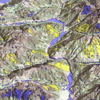
Italy is an extremely fragile territory, widely exposed to hydrogeological hazards affecting anthropic infrastructures and the natural environment. In this scenario, geomorphological maps, including the representation of the spatial distribution of landforms, have been used for a long time for the description of processes acting on the Earth’s surface. Geomorphological maps should represent the basic tool for the assessment of ...

Geodiversity refers to the variety of natural abiotic features, as the natural variety of geological (rocks, minerals), geomorphological (landforms, physical processes), hydrological and soil properties. The parameter “geomorphodiversity” is a measure of the dynamics of the Earth's surface and it has a key role in conservation of biodiversity and sustainability of ecosystems. Thus, it affects evolution of the biotic world and of human life. ...
A landslide is the movement of a mass of rock, debris or earth along a slope under the influence of gravity.
Landslides pose serious threats in many areas of the world, and knowing their location, distribution and classification is important for land use planning. Landslide identification and mapping is a fundamental activity for an effective defence from the damage caused by landslides to the population and to structures and the ...
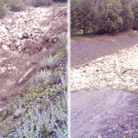
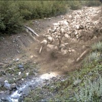
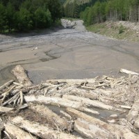
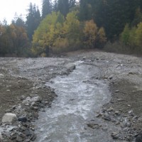
Not all that flows in creeks is water. Debris flows i.e., surges in which solid particles move together with little water, may occur in steep mountain streams, mainly as a consequence of intense rainfall. Debris flows have a high kinetic energy, and may cause major damage if they encroach buildings, roads and bridges. They are also a primary cause of landslide casualties. The video below shows an example of debris flows.
The low ...
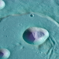
On Earth, landslides are hazardous phenomena often associated with economic damage and loss of human lives. The most common natural triggers of terrestrial landslides are intense or prolonged rainfall, earthquakes, rapid snow melting, and volcanic activity. But what are the main natural triggers of landslides on other solid bodies of the Solar System?
Since the early 70’s of the last century, landslides were observed on the surface of the ...
Landslide susceptibility is the propensity of a territory to generate landslides.
Many methods are available to determine landslide susceptibility, whereas only a few attempts were made to outline areas not likely to generate landslides i.e., non-susceptible landslide areas. This is surprising, because for planning purposes it is just as important (if not more important) to know where landslides are not expected than to know where landslides ...
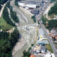
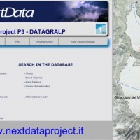
The IRPI Aerialphotografical archive consists of about 170000 aerial photographs of Northern Italy (1954-2005) useful for a stereoscopic vision. It also includes military flights (Royal Air Force) carried out during the Second World War. For some areas there are also rare aerial shots of the years 20, 30 and 40, often in diachronic form (5-10 years). The documentation refers to geo-hydrological events occurring on large areas and characterized ...
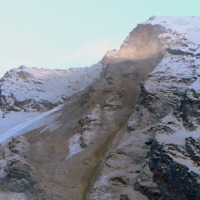
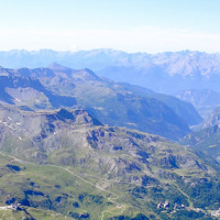
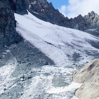
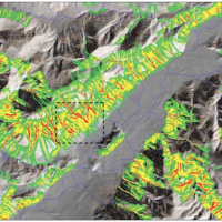
Climate change in the Greater Alpine Region is seriously affecting glacial and periglacial areas, especially for the presence of snow, glaciers and permafrost (cryosphere), with relevant consequences on slope stability. Cryosphere degradation, changes of the precipitation and temperature patterns and of the hydrological regimes, are some of the main terrestrial indicators of climatic change. Moreover, the increasing number of tourists and human ...
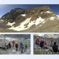
The researches at high-elevation sites continues, thanks to the RiST2 project (co-financed by Fondazione CRT of Torino). The study area is the Bessanese glacial basin. The Alpine environment and in particular the cryosphere, is responding quickly and with great intensity to climate change. The air temperature increase observed in the Alps urge the scientific communities involved in natural instability studies to consider not only air ...
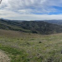
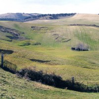
The Aosta Valley region presents a landscape almost totally occupied by mountain. In this context, a number of meaningful landslides is present, which vary from rock falls to deep-seated gravitational slope deformation (DsGSD), passing for the complex landslides. The study of these phenomena, finalized to guarantee suitable standard of safety and to facilitate a compatible development, results a fundamental necessity for this ...
The Alpine environment, and in particular the high-altitude one, is responding quickly and with great intensity to climate change, through evidences of geomorphological, hydrological and ecological type. Mountain glacier shrinkage and related outcropping of rock walls and debris, changes of the precipitation and temperature patterns, are some of the main terrestrial indicators of climatic ...
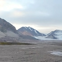
This project is embedded within the framework of the three Ny-Ålesund flagships: ‘Kongsfjorden system’, ‘Glaciology’ and ‘Terrestrial system’. The study of slopes and landscape modifications under a changing climate, is needed to understand the dynamic interaction between the cryosphere, hydrosphere, geosphere and biosphere, and how geosuccession and biosuccession (colonisation) processes develop over time. Records of landscape ...

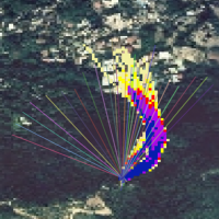
The 3DA software is a new procedure that allows retrieving in near-real-time 3D surface deformation models starting from data acquired via robotized total stations or others system that acquire the surface displacements. The measurements are first pre-processed and then implemented on 3D maps that include vector arrows representative of the intensities and of the real directions of motion in a given system of coordinates. The 3D surface ...
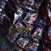
A Landslide Inventory Map (LIM) shows the location, spatial extent and type of landslides in a ...
Earthquakes and strong rainfall precipitations, cause worldwide landslide. Inventories of the ground effects of an event must be prepared in a few days or less for the residual risk management. Satellite images and image analysis techniques have started to back up traditional mapping methods. Purpose of this project is to increase the automatization of image ...

Water and sediment connectivity has emerged in recent years as a significant conceptual framework for understanding the transfer of surface water and sediment through landscapes. Connectivity can be seen both as a driver of hydrological and geomorphic processes within a catchment and as an emergent catchment property that is the result of processes acting at different ...
In Italy rainfall are among the main causes of trigger of shallow landslides, that yearly cause fatalities, damage, and severe economic losses. Identification of the amount of rainfall needed to trigger landslides, and the forecasting of rainfall-induced landslides, are of interest for the scientific community, as well as for the whole ...
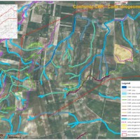
Il progetto GeSeFlu nasce dalla necessità della Regione Lombardia mediante il Piano Operativo Regionale (Direttiva Comunitaria 2000/60/CE) di disporre di specifici Programmi di Gestione dei sedimenti per i sottobacini redatti in attuazione della Direttiva del Comitato Istituzionale dell’Autorità di Bacino del fiume Po (deliberazione n. 9 del 5 aprile ...
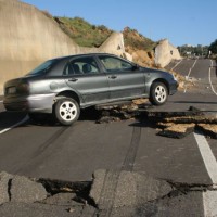
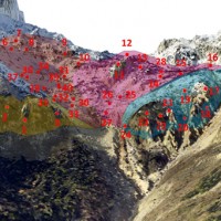
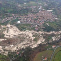
On December 3, 2013, a large landslide activated on the SW slope of Montescaglioso (Matera province, Basilicata), affecting an area with evidence of past instability. The landslide involved some 500 m of the main road to the village, and also interested several houses and other ...
Glaciers are widely recognized as the best terrestrial indicator of climate change. Nevertheless, occurred changes, even in recent times, are often poorly known. Italy has a unique, secular history of glaciological documentation that, jointly with a rich wealth of spatial, multitemporal data, allows an accurate reconstruction of recent glacier evolution. Unfortunately, these data are dispersed and/or difficult to ...
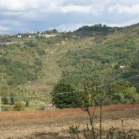
Castelfranci (Avellino, Campania) is located in the catchment of the Calore River, in correspondence of a N-S oriented stretch of the river. This territory is intensely affected by landslide development, which more than once was in the past at the origin of severe damage to the local community, and heavy losses to ...
The project explores and implements multi-scale and multi-sensor SAR change detection methodologies for event landslide mapping. Automated analysis for change detection is a challenging task due
to the inherent noisiness of SAR imagery and also to the high sensitivity to texture variability due to different acquisition angles. Moreover, pre-processing (de-speckling) may lead to the degradation
of the geometrical details and affect the ...
The understanding of the changing equilibrium between sediment supply from upstream and sediment transport capability of a river is important for the success of integrated water resource management. In Alpine river basins, intensive sediment transport processes and sediment continuity have a notable impact on several water management issues posing multiple use conflicts related to hydropower, ecology, flood control ...
At the beginning of November 2010 exceptional rainfall events stroke the Veneto Region causing the re-activation of the Rotolon landslide which is a serious threat to the town of Recoaro Terme, Vicenza, ...
Taiwan, an active orogenic belt with subtropical climate is characterized by a high uplift rate and several major typhoons each year. Italy is on one of the most seismically active regions in Europe because of the thrust of African plate on Eurasian continental one. Both experience numerous landslides along with earthquakes and intense rainfalls, causing heavy damages and casualties. The purpose of this project was to share scientific knowledge ...
Sediment transport in small mountain catchments (drainage area < 10-20 km2) is a fundamental process for the equilibrium and the dynamics of the whole channel network. At the same time, sediment transport can create high-risk conditions due to the occurrence of extreme phenomena such as debris flow, hyperconcentrated flow, and flood with intense bedload, usually triggered by intense and short duration rainfall. In order to properly manage ...
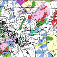
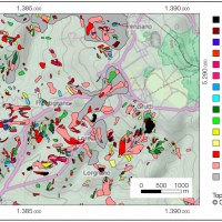
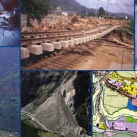
Existing geomorphological maps on the Apulian territory show some inconsistencies, that might have effects as concerns the limits of restriction areas for the location of works. To have available an updated and scientifically sound product, TRE Spa asked CNR IRPI a scientific consultancy for the production of geomorphological ...
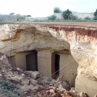
Within the framework of the project “Register of the Caves and Artificial Cavities of Apulia Region” (PO FESR 2007-2016), committed by the Ecology Service to the Apulian Speleological Federation (FSP), this latter involved CNR-IRPI to guarantee high scientific value to the documents to be produced, and to work with the cavers in the different phases of the ...
Decision matrices may contribute to mountain watershed management by defining coherent event scenarios that take into account the type of flow processes (e.g., water floods with bedload, debris flows), their geomorphic effects, and the interactions with hydraulic control ...
In the winter of 2009-2010, after the previous winter 2008-2009 when widespread hydrogeological instabilities had affected the whole of Calabria, the same area was still hardly hit by numerous and heavier instability phenomena, punctual and areal. In the context outlined it was ordered by the Italian Government to draft a "Plan excerpt for urgent action" which covered, in particular, the main city of the region, Catanzaro (Ianò district), and ...
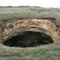
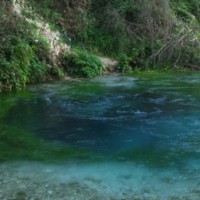
Sinkholes occur as sudden collapses of the ground, related to natural cavities produced by karst processes in soluble rocks, or to man-made cavities deriving from different types of human activities in different historical ages. Sinkholes are widespread all over the world, and the related hazard is extremely high, with very severe damage to built-up areas and human infrastructures, and heavy losses to the ...
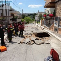
The widespread sinkholes that involve large sectors of the Apulian territory are related to natural cavities produced by karst processes in soluble rocks, or to man-made cavities deriving from different types of human activities in different historical ages. The related hazard is extremely high, with very severe damage to built-up areas and human infrastructures, and heavy losses to the ...
The high fragility of karst terrains, and the deriving vulnerability to a number of possible events, together with the presence of significant natural (first and foremost, groundwater), landscape and historical resources, are at the origin of the project activities, aimed at the safeguard of karst environments and the mitigation of the related ...
The territory of Calabria is affected by numerous landslides and, more generally, has a strong propensity to develop hydrogeological instability. A measure of this condition is provided by the data of the current PAI, limited to the examined areas (villages and households with more than 200 inhabitants), that identifies over 1700 high-risk situations and more than 700 at very high risk: a total of over 2,400 situations in which a hazard to the ...
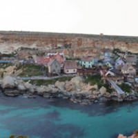
The research project can be included within the context of increasing hydrogeological instability also due to climate change and aims at investigating coastal instability in the island of Malta. This aspect has been until now slightly dealt with, despite significant risk issues, as evidenced from a series of accidents/damages recorded after landslide ...
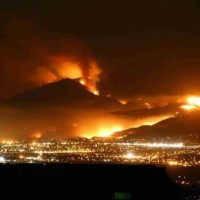
Wildfires can have profound effects on the hydrologic response of watersheds, and debris-flow activity is among the most destructive consequences of these effects. The continued high likelihood of catastrophic wildfires in Mediterranean climates has created the need to develop methods to identify and quantify potential debris flow hazards from burned ...
The observed increase in disastrous events over the last decades, associated with a low perception of risk by the communities involved, along with the lack of efficient, socially accepted and environmentally sound remedial measures are amongst the motivation behind this research project. The adaptation of a combined multi-risk-oriented analysis, in which the investigations focus more on the interdependence of events rather than on single event, ...
The Strategic Project PS_119 was aimed at developing a methodology for the landslide risk assessment, applicable at the regional scale and based on the most advanced knowledge in the fields of geology, geotechnics, structural engineering and urban planning. This assessment was based on a deterministic approach of the landslide processes and the risks related to them. The failure slope mechanisms, the structural damages due to landsliding and ...
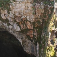
Evolution of cave and karst system occurs also by means of successive detachments of blocks from both the vault and the walls of the underground spaces. In show caves, this poses problems for the safety of visitors, and the issue must be carefully ...
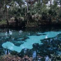
Sinkholes are among the main features of karst areas, and are extremely widespread in Florida, one of the sites most known for their occurrence and the likely interaction with the built-up environment. The Tampa area, in turn, shows an high frequency of events, which origin derives from different types of ...
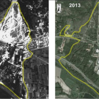
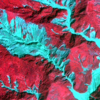
The study of the evolution of the watercourses is traditionally based on the use of historical maps and aerial photographs for the comprehension of the planimetric changes and on the use of topographical sections in order to have also the measure of the altimetric change occurred in the considered time interval.
Through this approach it is possible, for the Po basin, to have the first indications of the main watercourses evolution starting ...
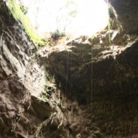
Evolution of cave and karst system occurs also by means of successive detachments of blocks from both the vault and the walls of the underground spaces. In show caves, this poses problems for the safety of visitors, and the issue must be carefully ...
About 25% of Albania is interested by karst landscapes in both carbonates and evaporite rocks, with a variety of surface and subsurface landforms worth to be exploited. Despite their high value in terms of natural heritage, in the past years these areas suffered from degradation and pollution problems, that were further exacerbated by the difficult social and economical situation of the Balkans in the ...
Debris flows and rockfalls are a familiar hazard in European mountain areas and regularly cause loss of life, livelihood and property. Hazard assessment is therefore increasingly required in land use planning. However, there are no standard techniques and existing operational techniques are qualitative.
DAMOCLES developed quantitative technologies for assessing the distribution of rapid slope failures and their hazard, for determining the ...
