
Puglia
The coloured circles represent the total number of activities (project, products and services, outreach, collaborations) that we have in the corresponding geographical zone
Map data: © OpenStreetMap contributors
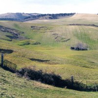
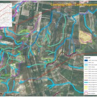
How much Mar Piccolo peculiarities are due to groundwater outflow
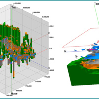 The Mar Piccolo basin is an internal sea basin located along the Ionian coast (Southern Italy), and it is surrounded primarily by fractured carbonate karstic environment.
In primarily karstic environments, infiltration is greater than runoff; in the karstic coastal Apulian aquifers, the groundwater discharge to the sea is more than two-fold greater than the surface discharge, notwithstanding the high discharges by wells. In such ...
The Mar Piccolo basin is an internal sea basin located along the Ionian coast (Southern Italy), and it is surrounded primarily by fractured carbonate karstic environment.
In primarily karstic environments, infiltration is greater than runoff; in the karstic coastal Apulian aquifers, the groundwater discharge to the sea is more than two-fold greater than the surface discharge, notwithstanding the high discharges by wells. In such ... Earthquake-induced landslides
 Landslides and earthquakes are important geological hazards in Italy, where mountains and hills dominate a landscape characterized by the presence of weak geological materials. The geological and morphological settings result in high susceptibility to landslides under seismic conditions. Italy is also one of the most active tectonic regions in Europe; and seismic shaking is known to have caused landslides in Italy.
Numerous historical ...
Landslides and earthquakes are important geological hazards in Italy, where mountains and hills dominate a landscape characterized by the presence of weak geological materials. The geological and morphological settings result in high susceptibility to landslides under seismic conditions. Italy is also one of the most active tectonic regions in Europe; and seismic shaking is known to have caused landslides in Italy.
Numerous historical ... Preventive evaluation of land instability hazards
 The urbanisation of seismically active areas, coupled with the ongoing change in climate patterns, require a shift in the approaches to land/infrastructure instability hazard assessment and risk reduction. This is particularly relevant in seismically active regions where the recurrent damage from landsliding, subsidence and ground deformations can be widespread. Geotechnical investigations and in situ monitoring of land prone to instability are ...
 Hydrogeological study for the risk analysis of a landfill.
 The company "Progetto Gestione Bacino Bari Cinque srl" has entrusted at the Research Institute for Geo-Hydrological Protection of the CNR the “Hydrogeological study for the risk analysis of the site where the plant of the treatment and disposal of solid urban waste of the same company is located in Contrada Martucci, municipality of Conversano ...
 Partenariato di studio e documentazione a supporto dell’attività legislativa sugli Obiettivi di Sviluppo Sostenibile e focus sul geoscambio termico
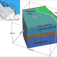 The topic of low geothermal enthalpy is crucial as a strategy to mitigate and adapt to climate change.
With this in mind, the structuring of environmental knowledge and information on the topic of low geothermal enthalpy in its various forms and a test site activity to deepen current knowledge on the regulatory context and on the effects on subsoil and on groundwater of geothermal plants is envisaged on a territorial ...
The topic of low geothermal enthalpy is crucial as a strategy to mitigate and adapt to climate change.
With this in mind, the structuring of environmental knowledge and information on the topic of low geothermal enthalpy in its various forms and a test site activity to deepen current knowledge on the regulatory context and on the effects on subsoil and on groundwater of geothermal plants is envisaged on a territorial ... Progetto PON Governance
 Il progetto prevede un’attività di servizio e di supporto tecnico scientifico per la realizzazione di progetti standard che affrontano i temi della pianificazione comunale di protezione civile e degli strumenti che possono rendere maggiore la sua efficacia. Il progetto propone uno schema che consente di definire, con metodologia rigorosa e omogenea, le attività da svolgere e il modo in cui svolgerle, per la realizzazione di un modello di ...
 Integrated assessment of geo-hydrological instability phenomena in the Apulia region, interpretative models and definition of rainfall thresholds for landslide triggering
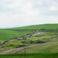 The Apulia region is affected by multiple types of geo-hydrological instability processes such as sinkholes, flash floods and landslides.
Landsliding mainly affects the north-western sector of the Region (bordering with Apennine chain) and the sea rocky cliffs.
The sub-Appennine Daunia portion of the Region is exposed to landslide risk due to hydro-geological setup of the soil/rock deposits, the poor mechanical properties of the ...
The Apulia region is affected by multiple types of geo-hydrological instability processes such as sinkholes, flash floods and landslides.
Landsliding mainly affects the north-western sector of the Region (bordering with Apennine chain) and the sea rocky cliffs.
The sub-Appennine Daunia portion of the Region is exposed to landslide risk due to hydro-geological setup of the soil/rock deposits, the poor mechanical properties of the ... Il patrimonio culturale è anche sotterraneo
 Sul mensile 'Almanacco della Scienza', a cura dell’Ufficio Stampa del Consiglio Nazionale delle Ricerche, un articolo che parla dell'evento di Taranto del 15 dicembre 2015 in cui è stato presentato il progetto "Il sottosuolo antropico meridionale". Per la prima volta, cinque Istituti di ricerca del CNR, tra i quali l'IRPI, uniscono le competenze in merito all'utilizzo antropico del sottosuolo nel meridione. In particolare Mario Parise ...
 Il comune di Taranto aderisce al progetto “Il sottosuolo antropico meridionale. Religione, infrastrutture, civiltà rupestre e buona pratica”
Il sito di informazione online della città di Taranto - www.tarantosette.it - dedica un'articolo al progetto "Il sottosuolo antropico meridionale. Religione, infrastrutture, civiltà rupestre e buona pratica", di cui anche l'Istituto di Ricerca per la Protezione Idrogeologica fa parte.
Vai all'articolo ... Frane e piene, il clima non c’entra
 Articolo a cura di Marisa Ingrosso sulla Gazzetta del Mezzogiorno del 17 agosto 2015, in cui l'ing. Maurizio Polemio, ricercatore presso la sede di Bari dell'Istituto di Ricerca per la Protezione Idrogeologica, spiega le cause dei disastri idrogeologici in ...
 RaiNews24: intervista a Mario Parise sugli eventi che hanno colpito la zona di Ginosa nel 2013 e 2014
 Mario Parise, responsabile della Sede Secondaria di Bari del CNR IRPI, viene intervistato l'11 agosto 2015 da RAI NEWS 24 in relazione agli eventi che hanno colpito la zona di Ginosa nel 2013 e 2014, isolando gran parte del centro storico.
Link al video (intervento di Mario Paridse a partire dal minuto ...
Mario Parise, responsabile della Sede Secondaria di Bari del CNR IRPI, viene intervistato l'11 agosto 2015 da RAI NEWS 24 in relazione agli eventi che hanno colpito la zona di Ginosa nel 2013 e 2014, isolando gran parte del centro storico.
Link al video (intervento di Mario Paridse a partire dal minuto ... Intervista a Mario Parise sull’emittente televisiva Telerama
Mario Parise, responsabile della Sede Secondaria di Bari del CNR IRPI, viene intervistato dall'emittente televisiva Telerama, nell'ambito della rubrica "Terre del Salento", in relazione alle cave sotterranee di Cutrofiano (provincia di Lecce) e ai relativi fenomeni di instabilità.
Link al video (intervento di Mario Paridse a partire dal minuto ... Monitoraggio del Rischio da Frane con tecnologie EO
 Le frane sono eventi del tutto naturali nell’evoluzione di un territorio, in particolare in Italia. Esse pongono un problema e diventano un pericolo allorché interagiscono con l’uomo e l’ambiente antropico. I movimenti franosi presentano una grande varietà fenomenologia. Le notevoli differenze nella tipologia, dimensione, e velocità di spostamento delle frane, rendono difficile e complessa la definizione della loro pericolosità, per ...
 Rainfall thresholds for the possible initiation of rainfall-induced landslides in Apulia
 In Italy rainfall are among the main causes of trigger of shallow landslides, that yearly cause fatalities, damage, and severe economic losses. Identification of the amount of rainfall needed to trigger landslides, and the forecasting of rainfall-induced landslides, are of interest for the scientific community, as well as for the whole ...
 Instability problems related to man-made cavities in the Municipality of Ginosa
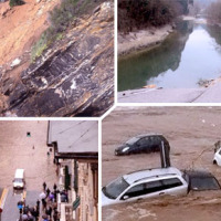
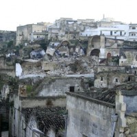 The territory of Ginosa was severely affected by flood and instability problems in October and in December 2013, as many other municipalities at the boundary between Apulia and Basilicata. In particular, on October 7, 2013, four fatalities and serious damage had to be registered. Following these events, other instabilities have occurred, including the collapse of a stretch of Via Matrice, above artificial cavities, on January 21, ...
 Analysis of instabilities in the historical centre of Mesagne
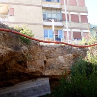
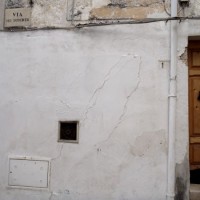 The instabilities that affected the historical part of Mesagne (Brindisi province, Apulia) since January 21, 2014, induced the local Authority to issue evacuation decrees for 18 families, corresponding to a total of 26 people. CNR IRPI was asked to provide scientific support for the identification of the processes at the origin of the ...
 Advanced and Integrated Monitoring of Earth DAMS
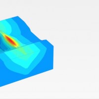 The project AIM-DAMS is aimed at developing a laboratory of integrated and advanced environmental monitoring for the control of the behavior of the earth-dams due to the different factors acting on the dams during their lifetime. Based on the integration of innovative and non-invasive sensors, as well as recent monitoring techniques and numerical modelling, the project is intended to fulfill the need of the dam management agencies of using ...
 Stability analysis in the Fantiano quarries
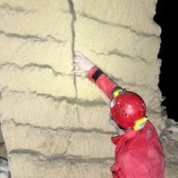
 The Fantiano quarries at Grottaglie (Taranto province) are an ancient sector of extraction of the local calcarenite rock, that is now used for concerts and shows. The instability phenomena observed in the quarries forced the Municipality of Grottaglie to ask to CNR-IRPI to perform stability analyses in the ...
 Geothermal Atlas of Southern Italy Project
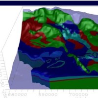
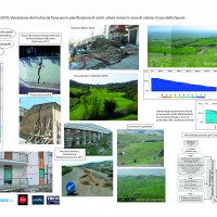
 The Geothermal Atlas project is aimed at the characterization, classification and mapping of geothermal resources, conventional and unconventional types, for the production of electricity in the regions of Southern Italy. It also provides training and information stretched to increase the skills of the industry and the public's knowledge about the various aspects of geothermal energy, especially the unconventional, in order to promote the ...
 La Ricerca ITaliana per il MARE
 UK The Italian maritime cluster represents for Italy an important economic sector contributing to 2.6% of national GDP, 11% of production in the industry of transport, and using almost 1% of the units of work identified in the country, share as high as 2% including the impact of upstream and downstream, for a total of around 480,000 employees (Cluster and maritime development in Italy and in the regions CENSIS - September 2011). In the European ...
 Sinkholes in the Marina di Lesina area
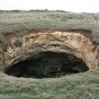
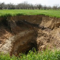
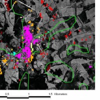
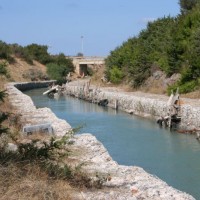 Sinkholes are in Apulia among the main geohazards, and are at the origin of severe interactions with the anthropogenic environment, and heavy losses to society. Since several years the territory of Marina di Lesina is diffusely affected by development of sinkholes (that have caused an emergency state to be declared), mostly concentrated near the Acquarotta Channel, linking the Lesina Lake to the Adriatic ...
 The Via Firenze Sinkhole of in the Municipality of Gallipoli
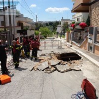
 Among the most recent sinkhole events, registered in Apulia region, that occurred in Via Firenze at Gallipoli on March 29, 2007, greatly raised the attention by public opinion, having affected (likely, without causing any fatalities) the built-up areas of one of the largest towns in Salento. The event pointed out to the need to carry out detailed studies on the sinkholes related to artificial ...
 Geomorphological studies on sectors of the Apulian territory
 Existing geomorphological maps on the Apulian territory show some inconsistencies, that might have effects as concerns the limits of restriction areas for the location of works. To have available an updated and scientifically sound product, TRE Spa asked CNR IRPI a scientific consultancy for the production of geomorphological ...
 Register of the caves and artificial cavities of Apulia
 Within the framework of the project “Register of the Caves and Artificial Cavities of Apulia Region” (PO FESR 2007-2016), committed by the Ecology Service to the Apulian Speleological Federation (FSP), this latter involved CNR-IRPI to guarantee high scientific value to the documents to be produced, and to work with the cavers in the different phases of the ...
 Evaluating the geothermal potential in the Southern Regions of Italy
 VIGOR contributed to increasing knowledge in exploitation of geothermal resources. It was aimed at providing information useful to start exploration and utilization of geothermal energy, through reconnaissance, analyses and studies, valorise geothermal resources in Calabria, Campania, Puglia and Sicily.
In particular, geological and geothermal characterization were carried both at regional scale (i.e. maps of geothermal potential) and at the ...
VIGOR contributed to increasing knowledge in exploitation of geothermal resources. It was aimed at providing information useful to start exploration and utilization of geothermal energy, through reconnaissance, analyses and studies, valorise geothermal resources in Calabria, Campania, Puglia and Sicily.
In particular, geological and geothermal characterization were carried both at regional scale (i.e. maps of geothermal potential) and at the ... DInSAR techniques for the assessment of sinkhole hazard
 Sinkholes occur as sudden collapses of the ground, related to natural cavities produced by karst processes in soluble rocks, or to man-made cavities deriving from different types of human activities in different historical ages. Sinkholes are widespread all over the world, and the related hazard is extremely high, with very severe damage to built-up areas and human infrastructures, and heavy losses to the ...
 GIS technologies for managing sinkhole hazard
 The widespread sinkholes that involve large sectors of the Apulian territory are related to natural cavities produced by karst processes in soluble rocks, or to man-made cavities deriving from different types of human activities in different historical ages. The related hazard is extremely high, with very severe damage to built-up areas and human infrastructures, and heavy losses to the ...
 Updating the list of Apulian municipalities with presence of man-made cavities
 The widespread occurrence of sinkholes related to man-made cavities in Apulia highlights the need to perform a careful reconnaissance of the artificial caves over the whole region, and of their stability conditions. Knowledge of the presence and typology of artificial cavity, and of its main features, is a mandatory step for the mitigation of the sinkhole ...
 Design and restore underground
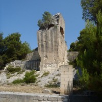
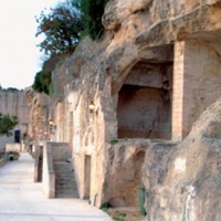 Puglia is one of the italian region with a higher density of hypogean sites of great value from the archaeological historical and artistic point of view. Many of them are in so precarious conditions that it is not possible to comprehend the precise history of the places and to define restoration interventions for their utilization and ...
 Landslide risk and urban planning in small settlements in Daunia
 The Strategic Project PS_119 was aimed at developing a methodology for the landslide risk assessment, applicable at the regional scale and based on the most advanced knowledge in the fields of geology, geotechnics, structural engineering and urban planning. This assessment was based on a deterministic approach of the landslide processes and the risks related to them. The failure slope mechanisms, the structural damages due to landsliding and ...
 Monitoring of the Castellana Caves
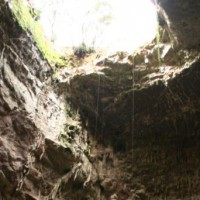
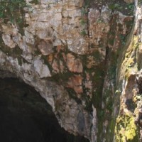 Evolution of cave and karst system occurs also by means of successive detachments of blocks from both the vault and the walls of the underground spaces. In show caves, this poses problems for the safety of visitors, and the issue must be carefully ...
 Landslide Early Warning Integrated System
 The focus on landslides results from the recognition that in many European countries slope instabilities affect urbanized areas and are a major threat to populations.
Through the integration of remotely sensed data with ground data we identify significant surface changes which are taking place on landslide susceptible slopes and this is used as input to the assessment of ...
The focus on landslides results from the recognition that in many European countries slope instabilities affect urbanized areas and are a major threat to populations.
Through the integration of remotely sensed data with ground data we identify significant surface changes which are taking place on landslide susceptible slopes and this is used as input to the assessment of ... Preliminary analysis of the stability conditions in some sectors of the Castellana Caves
 Evolution of cave and karst system occurs also by means of successive detachments of blocks from both the vault and the walls of the underground spaces. In show caves, this poses problems for the safety of visitors, and the issue must be carefully ...