
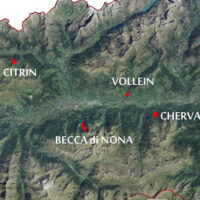
Valle d'Aosta
The coloured circles represent the total number of activities (project, products and services, outreach, collaborations) that we have in the corresponding geographical zone
Map data: © OpenStreetMap contributors
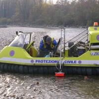
Gestione delle Monografie Operative relative ai grandi fenomeni franosi inseriti nella rete di monitoraggio della regione autonoma Valle d’Aosta
 The Aosta Valley is a small alpine region affected by numerous landslides, varying in size and type, ranging from isolated rock falls to rotational/translational slides up to extensive deep landslides. The study of such landslides, functional to a more effective risk management and to guarantee adequate safety standards, represents a primary necessity for a mountain territory like this ...
 Laboratorio a Cielo aperto delle Grandes Jorasses per lo sviluppo di tecniche di monitoraggio di processi di instabilità in ambito glaciale
 Climate change has a powerful impact on high-altitude Alpine sectors and glaciers. This impact often turns into an increase in instability processes that can lead to very high-risk conditions. These risk conditions can significantly affect the usability of areas characterized by intense tourist flows, making risk management very ...
 Role of climate change in the morphogenesis of glacial-periglacial environments and analysis of associated risks
 Climate change in the Greater Alpine Region is seriously affecting glacial and periglacial areas, especially for the presence of snow, glaciers and permafrost (cryosphere), with relevant consequences on slope stability. Cryosphere degradation, changes of the precipitation and temperature patterns and of the hydrological regimes, are some of the main terrestrial indicators of climatic change. Moreover, the increasing number of tourists and human ...
 Landslide Smart Network
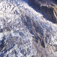
 Among all types of landslide phenomena present in Alpine environment, the rockfalls are certainly the most impacting, because they also are extremely widespread. Rockfall are very difficult to monitor and they are often managed exclusively through the execution of active or passive works aimed at risk mitigation. Due to the rockfalls impulsive behavior, it is a difficult task to locate them a priori. The problem of rockfalls can be approached ...
 We monitor the Planpincieux Glacier, along the Italian side of the Grandes Jorasses, Aosta Valley
 Glaciers are typical of the Alpine landscape, and an important source of water. Undoubtedly fascinating, glaciers are very complex and yet surprisingly poorly known. In the Alps, many studies focus on the volumetric changes of glaciers, proving their almost systematic reduction in the current climatic period. Little is known about the daily behaviour of Alpine glaciers. This is partly due to the inhospitable and not easily accessible ...
 Deep seated Gravitational Slope Deformation (DsGSD) analysis and criticalities assessment of the regional monitoring network of the landslides
 The Aosta Valley region presents a landscape almost totally occupied by mountain. In this context, a number of meaningful landslides is present, which vary from rock falls to deep-seated gravitational slope deformation (DsGSD), passing for the complex landslides. The study of these phenomena, finalized to guarantee suitable standard of safety and to facilitate a compatible development, results a fundamental necessity for this ...
 Se ne va il ghiaccio del Monte Rosa «Così le Alpi si fanno più piccole»
 Articolo pubblicato sul 'Quotidiano Nazionale', del 3 ottobre 2015, che descrive la situazione in cui versa il ghiacciaio del Monte Rosa interpellando anche, tra i vari esperti, il ricercatore associato dell'IRPI CNR di Torino, Giovanni Mortara.
[pdf-light-viewer ...
Articolo pubblicato sul 'Quotidiano Nazionale', del 3 ottobre 2015, che descrive la situazione in cui versa il ghiacciaio del Monte Rosa interpellando anche, tra i vari esperti, il ricercatore associato dell'IRPI CNR di Torino, Giovanni Mortara.
[pdf-light-viewer ... Aerofototeca
 The CNR IRPI archive preserves 170.000 aerial photographs useful for stereoscopic applications. Most part of those photographs were taken during a number of surveys carried out between 1954 and 2005 in tha Padan Plain, Triveneto and Liguria (Northern Italy) but some examples date from the 1920s, 1930s and 1940s.
In this documentation the effects of many floods and landslides events can be observed. In particular, we would mention the aerial ...
The CNR IRPI archive preserves 170.000 aerial photographs useful for stereoscopic applications. Most part of those photographs were taken during a number of surveys carried out between 1954 and 2005 in tha Padan Plain, Triveneto and Liguria (Northern Italy) but some examples date from the 1920s, 1930s and 1940s.
In this documentation the effects of many floods and landslides events can be observed. In particular, we would mention the aerial ... Postazione di monitoraggio a Mt. de La Saxe, Courmayeur
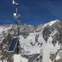
 13 Maggio 2015: È stata installata da parte del Geohazard Monitoring Group del CNR IRPI (U.O.S di Torino) la nuova postazione di monitoraggio del ghiacciaio di Planpincieux. Il Giacciaio di Planpicieux è uno dei ghiacciai del lato italiano del Massiccio del Monte ...
 Mountains fall down
 Radio interview (23/04/2014) to Daniele Giordan and Silvia Peppoloni by Rosella Panarese.
An active landslide of four hundred thousand cubic meters menaced to fall down from the Mont de la Saxe, near Courmayeur. Dozens of people evacuated, waiting for the landslide collapse. A continuous monitoring system that closely control the instable are evolution. Daniele Giordan, Research Institute for the hydrogeological Protection of the CNR of Turin, ...
Radio interview (23/04/2014) to Daniele Giordan and Silvia Peppoloni by Rosella Panarese.
An active landslide of four hundred thousand cubic meters menaced to fall down from the Mont de la Saxe, near Courmayeur. Dozens of people evacuated, waiting for the landslide collapse. A continuous monitoring system that closely control the instable are evolution. Daniele Giordan, Research Institute for the hydrogeological Protection of the CNR of Turin, ... In Courmayeur a complex active landslide linked to the recent evolution of a larger slope instability
La Repubblica, Italian newspaper, 22/04/2014.
Interview with Daniel Giordan on the recent evolution of the landslide of the Mont de La Saxe and related ... RelationsHips between meteo-climAtic paraMeters and ground surface deforMation time sEries in mountain enviRonments
 There is a systematic lack of information on the effects of the climate and environmental changes on the frequency and the intensity of landslides and their triggering phenomena (Huggel et al., 2012). The problem is particular severe in mountain area, where natural and human-driven climatic and environmental changes may alter significantly the frequency and the intensity of the slope processes, with largely unknown short and long-term effects ...
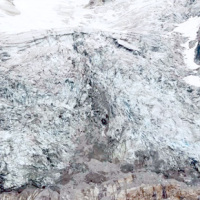
 Analysis and monitoring of Planpincieux Glacier, Monte Bianco massif (AO)
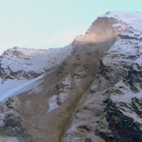
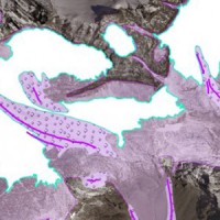
 The Planpincieux Glacier is one of the glaciers that characterize the Italian side of the massif of the Grandes Jorasses. It is considered a temperate glacier and its front is currently located near a morphological step that determines a strong propensity to the activation of frequent ice falls in particular during the summer. These phenomena are typical of this glacier, but its particular asset may cause, as already occurred in the past, to ...
 Analysis of the Mt. de La Saxe landslide
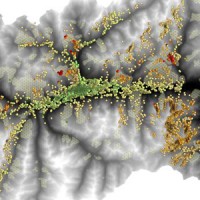
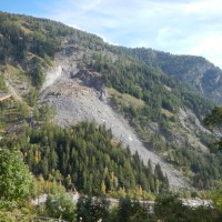 The Mont de La Saxe landslide affects the south-western side of Mont de La Saxe near Courmayeur, Valle d'Aosta. This landslide at present can be considered one of the most critical active landslides in the Italian Alps. The estimated unstable mass is more than eight millions of cubic meters and the main elements at risk are the hamlets of La Palud and Entreves, and the motorway access to the international tunnel of the Mont ...
 Micro-seismic network at the Carrel Hut on the Matterhorn
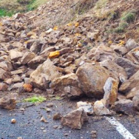
 The permafrost degradation is a probable cause of the increase of rock instabilities and rock falls observed in recent years in high mountain areas. It causes the thaw of the ice filling rock discontinuities producing water that subsequently freezes again, inducing stresses that lead to rock falls. Rock-falls are among the most hazardous instability processes in high mountain environments because of their velocity and the difficulty to ...
 Glacial hazards in the western Alps
 The project is included in Operative Program of the European cross-border territorial cooperation "Alcotra 2007-2013". It brings together specialized scientific expertise Italian and French that deal to study the mountain and its dangerousness. It is divided into a part of studies conducted on the entire framework of the Western Alps and in actions on the pilot sites identified by the ...
 Study of the riverbeds morphological evolution through the digital terrain models multi-temporal analysis
 The study of the evolution of the watercourses is traditionally based on the use of historical maps and aerial photographs for the comprehension of the planimetric changes and on the use of topographical sections in order to have also the measure of the altimetric change occurred in the considered time interval.
Through this approach it is possible, for the Po basin, to have the first indications of the main watercourses evolution starting ...
The study of the evolution of the watercourses is traditionally based on the use of historical maps and aerial photographs for the comprehension of the planimetric changes and on the use of topographical sections in order to have also the measure of the altimetric change occurred in the considered time interval.
Through this approach it is possible, for the Po basin, to have the first indications of the main watercourses evolution starting ...