
In Italy
The coloured circles represent the total number of activities (project, products and services, outreach, collaborations) that we have in the corresponding geographical zone
Map data: © OpenStreetMap contributors
Competenze e responsabilità: un problema aperto
 Articolo, scritto per la rivista Ecoscienza n. 3/2015, a cura di Fausto Guzzetti – CNR IRPI, riguardante il dissesto idrogeologico in Italia e alcune modalità diverse, a quelle fino ad ora attuate, per affrontare questo problema. A pagina ...
 Previsione operativa delle frane: il sistema sanf
Articolo, scritto per la rivista Ecoscienza n. 3/2015, a cura di Fausto Guzzetti – CNR IRPI, riguardante le caratteristiche del sistema di allertamento nazionale per la possibile occorrenza di fenomeni franosi. A pagina ... Statistica e modellistica per valutare il rischio frane
Articolo, scritto per la rivista Ecoscienza n. 3/2015, a cura di Fausto Guzzetti – CNR IRPI, riguardante la valutazione del rischio da frana. A pagina ... Frane e alluvioni, una lunga storia italiana
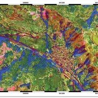
Articolo, scritto per la rivista Ecoscienza n. 3/2015, a cura di Fausto Guzzetti – CNR IRPI, riguardante frane e inondazioni in italia e il loro impatto sulla popolazione. A pagina ... STSE Water Cycle Multi-mission Observation Strategy for the Mediterranean
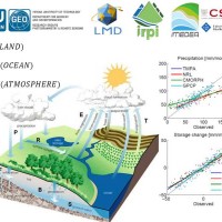 Monitoring the water cycle from satellite observations is one of the major goals of the EO community and closing the water budget has been a long-standing objective of international programs. After years of hard work, calibrating satellite data, improving inversion techniques, and facilitating the coherency of retrievals, it is admitted that the water cycle budget can now be ...
 Rischio frana due accordi per nuovi studi
Breve articolo dell'1 luglio 2015, scritto sul Messaggero Veneto, in cui si parla dell'IRPI CNR impegnato in due accordi per la prevenzione del rischio frana nella Valle del ... Photonics: Key Enabling Technologies at CNR
 The booklet, edited by the is reporting the main activities/results, within the Photonics KET (Key Enabling Technology), of all CNR’s Institutes, where there is a potential capability to underpin value chains in strategic areas, and thus to contribute to the scientific knowledge, to support the industrial leadership and to accelerate the development of advanced innovative solutions addressing societal challenges. And IRPI, with the research ...
 Giovani e ricerca, per il CNR vincono le donne
Articolo di attualità, pubblicato il 27/05/2015 su iodonna.it, che ritrae le storie dei quattro talenti italiani, tra i quali Angelica Tarpanelli (ricercatrice presso l'IRPI CNR di Perugia), che l'Accademia dei Lincei e il Consiglio Nazionale delle Ricerche hanno omaggiato per il loro contribuito allo sviluppo scientifico.
Vai ... Data on maximum annual rainfall in north-eastern Italy
 The database includes annual maximum rainfall corresponding to durations of 1, 3, 6, 12, 24 hours and 1, 2, 3, 4, 5 days for approximately 800 raingauges in north-eastern Italy (Trentino, Alto Adige, Veneto and Friuli Venezia Giulia). The database contains data until 1997 for the Autonomous Province of Bozen-Bolzano, 1990 for the Autonomous Province of Trento, and 1996 for Veneto and Friuli Venezia ...
 Aerofototeca
 The CNR IRPI archive preserves 170.000 aerial photographs useful for stereoscopic applications. Most part of those photographs were taken during a number of surveys carried out between 1954 and 2005 in tha Padan Plain, Triveneto and Liguria (Northern Italy) but some examples date from the 1920s, 1930s and 1940s.
In this documentation the effects of many floods and landslides events can be observed. In particular, we would mention the aerial ...
The CNR IRPI archive preserves 170.000 aerial photographs useful for stereoscopic applications. Most part of those photographs were taken during a number of surveys carried out between 1954 and 2005 in tha Padan Plain, Triveneto and Liguria (Northern Italy) but some examples date from the 1920s, 1930s and 1940s.
In this documentation the effects of many floods and landslides events can be observed. In particular, we would mention the aerial ... Historical ARchive of COsenza
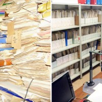 ARCO is the historical archive concerning the geo-hydrological events that occurred in Calabria (south Italy) between 1850 and 1990. The archive is made of 506 folders. 45 folders contain projects of land reclamation, management works of fluvial basins and refunding requests carried out after earthquakes. 461 folders, sorted per municipality, contain refunding requests due to geo-hydrological events, communications between citizens and public ...
 Postazione di monitoraggio a Mt. de La Saxe, Courmayeur
 13 Maggio 2015: È stata installata da parte del Geohazard Monitoring Group del CNR IRPI (U.O.S di Torino) la nuova postazione di monitoraggio del ghiacciaio di Planpincieux. Il Giacciaio di Planpicieux è uno dei ghiacciai del lato italiano del Massiccio del Monte ...
 Ricerca, il futuro è giovane
Articolo pubblicato nel portale meteoweb.eu il giorno 8 maggio 2015 a firma Peppe Caridi sulla consegna dei premi ‘Ricercatamente’, riservati a ricercatori under 35, promosso dal Consiglio nazionale delle ricerche e dall’Accademia nazionale dei lincei per valorizzare il talento dei giovani che hanno contribuito allo sviluppo della ricerca scientifica e tecnologica. Angelica Tarpanelli del CNR-IRPI di Perugia riceve il premio per i suoi ... Multi Scale and Multi Hazard MApping Space Solutions
 The exploitation of innovative methods of SAR and optical data processing, combined to the use of ancillary data, is able to provide useful products for the landslide and seismic hazard ...
 Cedimento del viadotto Himera sull’autostrada A19 presso Caltavuturo, Sicilia
 Intervento della dottoressa Paola Salvati (ricercatrice presso il CNR-IRPI di Perugia) alla trasmissione 'Uno Mattina' su RAI1 del giorno 13 aprile 2015, a seguito della frana che ha interrotto il viadotto Himera sull'autostrada A19 presso Caltavuturo e inerente al dissesto idrogeologico in Italia. Dal minuto ...
 I tecnici della Costa Concordia al lavoro per Ripe
Articolo del giorno 12 aprile 2015, sul quotidiano della provincia di Teramo 'La Città': i tecnici dell'IRPI che hanno monitorato la Costa Concordia ora alle prese con la frana di ... Rafforzato il rapporto con il CNR
Articolo del giorno 08/04/2015 del 'Corriere dell'Umbria' riguardante l'incontro del Presidente del CNR Luigi Nicolais e dei vari direttori del CNR di Perugia, con la Presidente della Regione Umbria Catiuscia Marini, avvenuto durante la mattinata del 7 aprile 2015 presso la sala conferenze ... Presidente Marini visita sedi e laboratori di Perugia
Resoconto della visita del 7 aprile 2015 della Presidente della Regione Umbria Catiuscia Marini nei centri di ricerca del CNR di Perugia, tra i quali lo stesso IRPI, dove si è svolto per gran parte l'incontro con il Presidente del CNR Luigi Nicolais e i direttori dei vari ... Un ‘polo della ricerca’ in via del Giochetto con Università e Cnr
Articolo del quotidiano online 'Umbria24' sull'incontro, avvenuto il 7 aprile 2015, tra il presidente del CNR Luigi Nicolais e la presidente della Regione Umbria Catiuscia Marini, insieme con i diversi direttori degli istituti del CNR che operano in ... Ripe di Civitella, prosegue il monitoraggio della Frana
Articolo pubblicato il 3 aprile 2015 dal quotidiano online 'L'Ancora Online' riguardante l'istallazione da parte del CNR-IRPI, di Torino e di Perugia, del sistema per il monitoraggio della frana di Ripe di Civitella (frazione del comune di Civitella del Tronto, in provincia di ... I danni di frane e inondazioni nel 2014
Articolo firmato da Alex Saragosa, pubblicato nel numero di marzo 2015 della rivista Le ... Alluvioni, incubo dei sindaci liguri. Ed è polemica sulle scuole chiuse
Articolo pubblicato su Repubblica, edizione Genova, il 4 marzo ... In cinquanta anni in Liguria morte centoventi persone per frane e alluvioni
Articolo pubblicato nel Corriere Mercantile il 4 marzo ... Il bilancio delle alluvioni che rende la Liguria la seconda regione in Italia per numero di vittime
Servizio di Primocanale news, edizione delle ore 13, andato in onda il 3 marzo 2015, in cui sono stati citati i dati forniti dall' IRPI-CNR.
[video width="320" height="240" ... Hydrological-hydraulic validation of satellite data
 The service aims to assess the potential of different satellite products (from active and passive micro-waves, optical, SAR, spectroradiometers, radiometers sensors) in retrieving the main hydrological-hydraulic variables such as rainfall, soil moisture, water level, flow velocity and discharge. This is pursued through a comprehensive validation analysis by using in-situ observed or modelled data for several sited located ...
 Prevenire le frane, Liguria capofila di un progetto del Cnr
Intervista trasmessa da Primocanale News a Fausto Guzzetti, direttore dell'Istituto di Ricerca per la Protezione Idrogeologica del CNR, in occasione del convegno “La responsabilità del sindaco nella protezione civile”, tenutosi a Genova il 3 marzo ... CNR-IRPI: in Liguria frane e inondazioni causano 120 vittime in 50 anni
Il TG di TeleGenova del 3 marzo 2015, edizione delle 19.15, cita i dati del CNR-IRPI.
[video width="320" height="240" ... CNR-IRPI: in 50 anni il dissesto idrogeologico ha causato in Liguria 120 morti
 Il GR regionale della Liguria del 3 marzo 2015, edizione delle 12.10, cita i dati del CNR-IRPI.
[audio ...
Il GR regionale della Liguria del 3 marzo 2015, edizione delle 12.10, cita i dati del CNR-IRPI.
[audio ... Control and validation of hydro-meteorological data
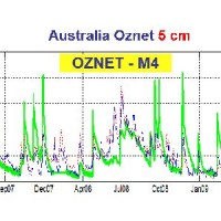
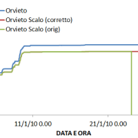 The analysis of hydro-meteorological data is required to verify the correct sensors functioning and possible presence of non-operational periods with missing data. When non-operational periods or malfunction occur, it could be possible to apply procedures for missing data reconstructions and wrong data ...
 Levees and bridges vulnerability
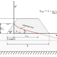
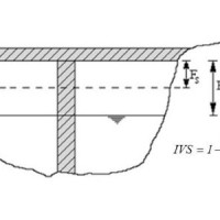 Assessment of bridge piers/abutments vulnerability to scour and overtopping hazard, assessment of levee vulnerability to seepage and overtopping hazard. The analysis is based on clearly identified criteria. Specifically, overtopping (IVS) and erosion (IVE) vulnerability indices are evaluated for each selected bridge, and the overtopping (IVsorm) and seepage vulnerability indices (IVsif) are calculated for the ...
 Flood events analysis
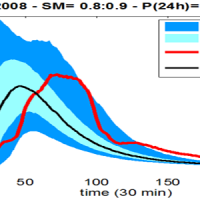
 The service is based on a procedure consisting of four main steps: the analysis of hydro-meteorological data for the reconstruction of flood event in terms of precipitations and saturation conditions of the soils; assessment of the hydrological response of the basin; runoff estimation in each hydrometric site of interest; flooded areas delineation and comparison with in-situ ...
 Climate change impact on extreme events
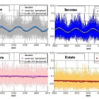 The service analyzes the climate change impact on the main hydro-meteorological variables involved in the hydrological cycle and, in particular, on extreme events of rainfall and discharge (droughts and floods). The service allows to evaluate the combined effects of natural and human processes related to climate change on surface runoff and groundwater, analyzing the possible consequences of such effects on the strategic water ...
 SM2RAIN dataset
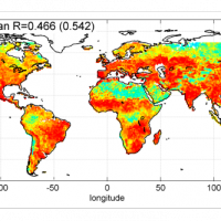 The rainfall dataset provides rainfall estimates obtained through the application of an inversion algorithm to soil moisture data. The algorithm has been applied to ground and satellite data, obtained through various satellite ...
 Forecasting system for geo-hydrological risk
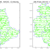 Real time evaluation of the rainfall and soil moisture conditions over the analysis grid point, and the combination with the available vulnerability and susceptibility information for the definition of the dynamic risk ...
 Hydraulic hazard maps
 Hydraulic hazard maps for return periods of 50, 100, 200 and 500 ...
 Dissesto idrogeologico. L’Italia di nuovo alle prese con pioggia e frane
Fausto Guzzetti, Director of the CNR "Istituto di Ricerca per la Protezione Idrogeologica", participates to the RAI 1 TV programme "Unomattina", on 27 February 2015. At ... Online il nuovo sito web dell’IRPI CNR
 Si aggiorna e cambia pelle il sito web dell'Istituto di Ricerca per la Protezione Idrogeologica (IRPI), uno dei dodici istituti del Dipartimento Scienze del Sistema Terra e Tecnologie per l'Ambiente del Cnr
Con il nuovo sito https://www.irpi.cnr.it è stato aggiornato anche il logo dell'Istituto. Il sito, con contenuti in italiano e in inglese, rappresenta la vetrina per i progetti di ricerca e di sviluppo tecnologico realizzati dall'Istituto ...
Si aggiorna e cambia pelle il sito web dell'Istituto di Ricerca per la Protezione Idrogeologica (IRPI), uno dei dodici istituti del Dipartimento Scienze del Sistema Terra e Tecnologie per l'Ambiente del Cnr
Con il nuovo sito https://www.irpi.cnr.it è stato aggiornato anche il logo dell'Istituto. Il sito, con contenuti in italiano e in inglese, rappresenta la vetrina per i progetti di ricerca e di sviluppo tecnologico realizzati dall'Istituto ... Aerial and terrrestrial LiDAR surveys
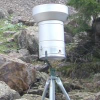
 The study of the evolution of the territory and especially of the of geo-hydrological instabilities can be often based on the use of high resolution digital terrain models. The possibility to make ad hoc surveys and repeat them over time can be useful for the identification and measurement of the topographic effects of a particular morphological process. LiDAR can be usually considered the best solution for the creation of high resolution DEM. ...
 Operational systems for flood wave forecasting (MISDc and STAFOM-RCM models) and flooding prediction (KS model)
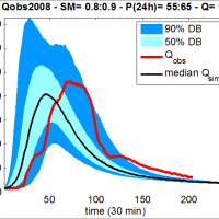
 Semi-distributed continuous hydrological model (MISDc) for real-time soil moisture estimate and river discharge prediction in the Upper-Middle Tiber River basin; flood wave routing model (STAFOM-RCM) for stage hydrograph forecasting at some selected hydrometric stations in the Tiber River basin; Rainfall-runoff database coupled with the kinematic model KS for an expeditious estimate of probability flooding ...
 Levees vulnerability database
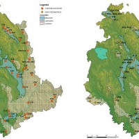
 National levees database, where the levees are identified by a code consisting in two parts: the first one identifies the river; the second one is a sequential number increasing from downstream to upstream. For each levee the location, the characteristics and topographic surveys are reported along with vulnerability to overtopping and piping, flood hazard maps and information about levee inspection and ...
 Siccità E Cambiamenti cLImatici
 SECLI Project is aimed to assess the combined effects of processes related to natural and anthropogenic climate change on water resources, both surface and groundwater, in the Umbrian territory, identifying the possible consequences of such effects on drinking water policy, and on how these may affect the existing system of withdrawals and ...
 Dynamic flooding scenarios
 The project activities were carried out in two phases:
"dynamic scenarios of flood risk" identification through hydrologic-hydraulic modeling addressed to Civil Protection activities (2009-2011);
operational implementation of developed dynamic scenarios of flood risk and results dissemination trough web-GIS technologies, also within the context of Floods Directive 2007/60 /EC (2012-203); flood forecasting models implementation; ...
The project activities were carried out in two phases:
"dynamic scenarios of flood risk" identification through hydrologic-hydraulic modeling addressed to Civil Protection activities (2009-2011);
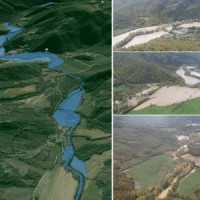
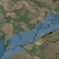
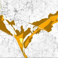
operational implementation of developed dynamic scenarios of flood risk and results dissemination trough web-GIS technologies, also within the context of Floods Directive 2007/60 /EC (2012-203); flood forecasting models implementation; ... Flooding-prone areas delineation
 The project activities were carried out in two phases:
delineation of flooding-prone areas for many river reaches selected in the secondary hydrographic network of Tiber River basin (2009-2011);
analysis of the severe flood event that affected the Paglia river basin on November ...
The project activities were carried out in two phases:
delineation of flooding-prone areas for many river reaches selected in the secondary hydrographic network of Tiber River basin (2009-2011);
analysis of the severe flood event that affected the Paglia river basin on November ... Analysis, control and hydro-meteorological data processing – Rating curve estimate
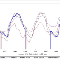 The activities of the project concerns the analysis and processing of hydro-meteorological data collected by the monitoring network of the Umbria Region for the period 1994-2014. In particular, the study regards the rainfall, temperature and water level time series. In addition, the discharge series corresponding to observed water levels are estimated for at hydrometric station through the rating curve estimated on the basis of flow velocity ...
 Flooding-prone areas delineation for hydraulic risk assessment for river reaches of the secondary hydrographic network in Tiber river basin
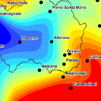
 The activities of the project concern the delineation of hazard maps for return periods of 50, 100, 200 and 500 years for many reaches of interest identified in the secondary hydrographic network of Tiber ...
 Integration of hydrometric measurements for river discharge monitoring and channel roughness coefficients assessment
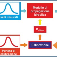 River discharge monitoring is fundamental for the study of the hydraulic regime of river flow and for the validation and calibration of rainfall-runoff models. The assessment of channel roughness coefficients associated with the measured discharges is fundamental for the calibration of flood routing models that can be used to address civil protection activities in real time. Unfortunately, the number of river flow monitoring stations in the ...