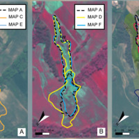
Landslides leave discernible signs on the land surface, most of which can be captured in remote sensing images. On the images the signs appear as modification of the photographic characteristics as tone, colour, mottling and texture, or/and as modification of morphological characteristics including shape, curvature, convexity and concavity. These signs are the landslide signature. Trained geomorphologists analyse remote sensing images and map ...
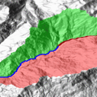
Quantitative geomorphological and environmental analysis requires the adoption of mapping units, well-defined spatial domains as basic mapping units which provide local boundaries to aggregate environmental and morphometric variables and to perform calculations. Grid cells, typically aligned with a digital elevation model, are the standard mapping unit choice. A wiser choice is represented by slope units, irregular terrain partitions delimited ...
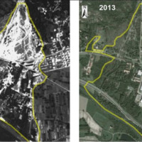
The IRPI Aerialphotografical archive consists of about 170000 aerial photographs of Northern Italy (1954-2005) useful for a stereoscopic vision. It also includes military flights (Royal Air Force) carried out during the Second World War. For some areas there are also rare aerial shots of the years 20, 30 and 40, often in diachronic form (5-10 years). The documentation refers to geo-hydrological events occurring on large areas and characterized ...
Making reports of rockfall in the area affected by the earthquake in central Italy in ...
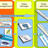
We provide maps and layers through standard OGC services and WebGIS applications.
Our aim is to disseminate information on landslides and floods hazards and the related risk.
More specifically the services focus on thematic data concerning landslides and floods, including: (i) landslide inventory maps at different scales and covering different geographical areas, (ii) landslide susceptibility, hazard and risk maps, and (iii) information on ...
Earthquakes and strong rainfall precipitations, cause worldwide landslide. Inventories of the ground effects of an event must be prepared in a few days or less for the residual risk management. Satellite images and image analysis techniques have started to back up traditional mapping methods. Purpose of this project is to increase the automatization of image ...
Glaciers are widely recognized as the best terrestrial indicator of climate change. Nevertheless, occurred changes, even in recent times, are often poorly known. Italy has a unique, secular history of glaciological documentation that, jointly with a rich wealth of spatial, multitemporal data, allows an accurate reconstruction of recent glacier evolution. Unfortunately, these data are dispersed and/or difficult to ...
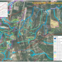
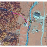
The occurrence of flash floods in mountainous catchments is often associated to relevant geomorphic effects, both in the channel network (channel changes and transport of large wood), and on the hillslopes (landslides and soil erosion). The concomitance of flash floods, channel changes and landslides enhances hazards and risk associated to individual ...
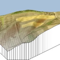
The application of distributed physically based models is possible on relatively small areas, typically hundreds or few thousands of km2. Distributed modelling of slope dynamics requires many sufficiently detailed information. Knowledge of geotechnical parameters and land use, digital terrain models, medium/high resolution cartography, temporal evolution of soil moisture conditions, are ...

The Geothermal Atlas project is aimed at the characterization, classification and mapping of geothermal resources, conventional and unconventional types, for the production of electricity in the regions of Southern Italy. It also provides training and information stretched to increase the skills of the industry and the public's knowledge about the various aspects of geothermal energy, especially the unconventional, in order to promote the ...
Existing geomorphological maps on the Apulian territory show some inconsistencies, that might have effects as concerns the limits of restriction areas for the location of works. To have available an updated and scientifically sound product, TRE Spa asked CNR IRPI a scientific consultancy for the production of geomorphological ...
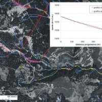
The accurate representation of the channel network is fundamental in cartography. The increasing availability of high-resolution, LiDAR-derived DTMs provides an excellent topographic basis for the representation of the channel network, but requires innovative techniques for managing and processing ...
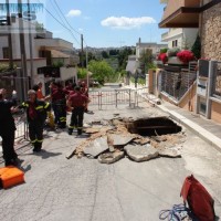
The widespread sinkholes that involve large sectors of the Apulian territory are related to natural cavities produced by karst processes in soluble rocks, or to man-made cavities deriving from different types of human activities in different historical ages. The related hazard is extremely high, with very severe damage to built-up areas and human infrastructures, and heavy losses to the ...
The assessment debris-flow hazard is of utmost importance in the management of alpine catchments. The analysis of morphometric variables of drainage basins and channels can contribute to preliminary assessment of debris-flow hazard at regional ...
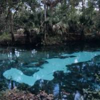
Sinkholes are among the main features of karst areas, and are extremely widespread in Florida, one of the sites most known for their occurrence and the likely interaction with the built-up environment. The Tampa area, in turn, shows an high frequency of events, which origin derives from different types of ...
