
In Italy
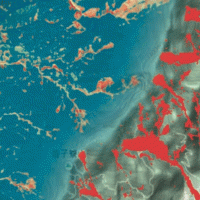
The coloured circles represent the total number of activities (project, products and services, outreach, collaborations) that we have in the corresponding geographical zone
Map data: © OpenStreetMap contributors
Rischio: gli italiani temono più l’uomo che la natura
 Comunicato stampa CNR del 7 maggio 2013 inerente l’indagine sulla percezione dei rischi commissionata dall’Istituto di ricerca per la protezione idrogeologica alla ...
 Sulla frana di Castelfranci interviene il CNR. Indagini scientifiche dell’IRPI
Articolo pubblicato sul quotidiano OTTOPAGINE, del 26 aprile 2013, riguardante la frana di Castelfranci, provincia di Avellino ... Ambiente: 9mila vittime tra 1950 e 2012. Danni per 240 mld euro
Lancio dell'Agenzia ASCA del 28 marzo 2013 riguardante l'intervento effettuato da Fausto Guzzetti e Roberto Zoboli nell'ambito della XIII Giornata Mondiale dell’Acqua. Convegno: "Calamità idrogeologiche: aspetti economici", organizzato dall'Accademia dei Lincei. Roma, 22 marzo ... Landslide Modelling and tools for vulnerability assessment Preparedness and REcovery management
 Il progetto FP7 LAMPRE - Landslide Modelling and tools for vulnerability assessment Preparedness and Recovery management svolge attività di ricerca innovative e di sviluppo tecnologico per migliorare le capacità del sistema Copernicus di far fronte a eventi di frana e alle loro conseguenze, in Europa e in altre parti del mondo. LAMPRE migliora il rischio di frana sforzi di mitigazione / preparazione e le attività di recupero e di ...
 Alarm and monitoring systems for debris and mud flows
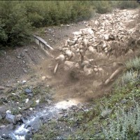
 Monitoring of debris flows in instrumented areas is carried out since many years in different Countries worldwide. It is still missing, however, an adequate standardization of methodologies, instrumentations and procedures. The instrumented areas are also employed for testing warning systems. Even though these latter have been more and more employed, a systematic experimentation of these systems has not yet been carried ...
 Increasing Resilience through Earth Observation
 To significantly contribute to the operational capacities in the context of Global Monitoring for Environment and Security (GMES)/ Copernicus by developing customised mapping and geo-information products addressing risk, vulnerability and assets ready for deployment in the prevention and preparedness phases – complementary to the GMES/Copernicus Emergency Management Service. Solutions to be provided are based for the most part on Earth ...
 L’Italia frana e affonda. Spende più per tamponare i danni che per mettere in sicurezza del territorio
Articolo pubblicato da Stefano Natoli nel blog "Il dato è tratto" del Sole 24ore il 15 novembre ... Dal 1960 4 mila vittime di frane e inondazioni
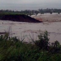
Articolo pubblicato dall'agenzia ANSA il 14 novembre ... Piove di più, nessuno cura i fiumi, così il maltempo diventa una tragedia
Articolo di Elena Dusi pubblicato su La Repubblica del 14 novembre ... Gli esperti e le evacuazioni: In due mesi 22 allarmi. Sta piovendo troppo sul territorio abbandonato
Articolo di Alessandra Mangiarotti pubblicato sul Corriere della Sera del 12 novembre ... RIVERbank Surveillance bAsed on Fiber optic sEnsors
 In the last decades Europe and Italy suffered many damaging floods, causing thousands of deaths, the displacement of millions of people and billions of euros in insured economic losses. Veneto Region has been also strongly stricken in 2010. The European Commission has identified the need for adaptation of risk management in several documents in order to reduce the likelihood and/or the impact of floods [1]. Starting from these remarks, the main ...
 Analysis of the Mt. de La Saxe landslide
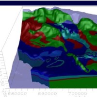
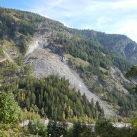 The Mont de La Saxe landslide affects the south-western side of Mont de La Saxe near Courmayeur, Valle d'Aosta. This landslide at present can be considered one of the most critical active landslides in the Italian Alps. The estimated unstable mass is more than eight millions of cubic meters and the main elements at risk are the hamlets of La Palud and Entreves, and the motorway access to the international tunnel of the Mont ...
 Geo-hydrological hazards in the Pogliaschina catchment
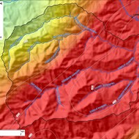 The occurrence of flash floods in mountainous catchments is often associated to relevant geomorphic effects, both in the channel network (channel changes and transport of large wood), and on the hillslopes (landslides and soil erosion). The concomitance of flash floods, channel changes and landslides enhances hazards and risk associated to individual ...
 Climate change on slope failures initiation in the Italian Alps
 Climate change in the Greater Alpine Region is seriously affecting glacial and periglacial areas, with relevant consequences on slope stability. Cryosphere degradation, changes of the precipitation and temperature patterns and of the hydrological regimes, are some of the main terrestrial indicators of climatic change. Moreover, the increasing number of tourists and human activities rise the level of ...
 Sediment management in Alpine basins
 The understanding of the changing equilibrium between sediment supply from upstream and sediment transport capability of a river is important for the success of integrated water resource management. In Alpine river basins, intensive sediment transport processes and sediment continuity have a notable impact on several water management issues posing multiple use conflicts related to hydropower, ecology, flood control ...
 Monitoring system for the Hahnebaum test site
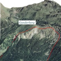 A Deep-seated Gravitational Slope Deformation (DGSD) affects the south-west flank of mount Ganderberg (Moso in Passiria – BZ). The continuous displacements of the landslide induce secondary hazardous phenomena. A 800.000 m3 rock slab shows signs of incipient movement; a detachment could create a natural barrier on the river ...
 Real-time monitoring of the “San Lorenzo” tunnel, Passo della Morte
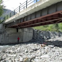
 The entrance of the tunnel "San Lorenzo" in Forni di Sotto (UD) has built over a an active landslide body. The gravitational deformations of the slope are damaging the lining of the tunnel and creating a hazardous ...
 Spatially distributed modelling of landslide phenomena
 The application of distributed physically based models is possible on relatively small areas, typically hundreds or few thousands of km2. Distributed modelling of slope dynamics requires many sufficiently detailed information. Knowledge of geotechnical parameters and land use, digital terrain models, medium/high resolution cartography, temporal evolution of soil moisture conditions, are ...
 Cose da fare – Errori da evitare
Articolo di Gian Antonio Stella pubblicato nel Corriere della Sera del 31 maggio ... Una valutazione economica dei danni causati dai disastri naturali
Articolo di Silvio Casucci e Paolo Liberatore pubblicato in Eddyburg.it il 29 maggio ... Variante, i residenti: «Il viadotto si è spostato di 3 centimetri»
Articolo di Noemi Bicchiarelli pubblicato su corrieredibologna.it il 22 maggio ... Variante Valico, tutte le parti in commissione
Articolo pubblicato su bologna2000.com il 22 maggio ... Study and monitoring of the Rotolon landslide
 At the beginning of November 2010 exceptional rainfall events stroke the Veneto Region causing the re-activation of the Rotolon landslide which is a serious threat to the town of Recoaro Terme, Vicenza, ...
 Ripoli, i cantieri ripartono «Ma controlli più mirati»
Articolo di Amelia Esposito pubblicato su corrieredibologna.it il 3 maggio ... Frana la Variante di Valico, pronto un piano di evacuazione dei paesi
Articolo di David Marceddu pubblicato il 3 maggio 2012 su ilfattoquotidiano.it edizione ... Variante di valico, i costruttori: “Inutilizzabile l’autostrada del Sole”
Articolo di Luigi Spezia pubblicato il 3 maggio 2012 su laRepubblica.it edizione di ... Le emergenze tra errori umani e scienza
 Intervista di Barbara Serra a Fausto Guzzetti trasmessa su Rai Tre nel programma Cosmo del 22 Aprile 2012 (a partire dal minuto 24 circa al minuto 38 ...
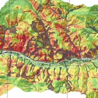
 Zonazione della suscettibilità da frana si scorrimento in Umbria
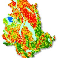 Realizzazione di modelli e carte di suscettibilità da frana tipo scorrimento per il territorio della Regione ...
 Alluvioni e frane: in Italia 10mila morti e 350 mila sfollati negli ultimi 112 anni
Articolo di Peppe Caridi pubblicato il 27 febbraio 2012 su ... La terra violata
Intervista a Fausto Guzzetti andata in onda su RaiTre il 29 Gennaio 2012 nella trasmissione Presadiretta di Riccardo Iacona.
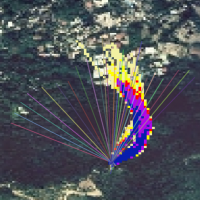
[video width="640" height="480" ... Topographic monitoring of the Costa Concordia vessel wreck
 Following the run aground off near the "Isola del Giglio" (Tuscany, Italy, January 13, 2012) of the cruise vessel "Costa Concordia", a monitoring system for handling the security of the SAR (Search and Rescue) operations and for the control of the ships' movements/deformations during the subsequent defueling and recovery phases has been progressively installed and ...
 L’ingegneria nei 150 anni dell’Italia unita
Articolo di Rita Viola pubblicato in Almanacco della Scienza n. 1 del 18 gennaio ... Geothermal Atlas of Southern Italy Project
 The Geothermal Atlas project is aimed at the characterization, classification and mapping of geothermal resources, conventional and unconventional types, for the production of electricity in the regions of Southern Italy. It also provides training and information stretched to increase the skills of the industry and the public's knowledge about the various aspects of geothermal energy, especially the unconventional, in order to promote the ...
 La Ricerca ITaliana per il MARE
 UK The Italian maritime cluster represents for Italy an important economic sector contributing to 2.6% of national GDP, 11% of production in the industry of transport, and using almost 1% of the units of work identified in the country, share as high as 2% including the impact of upstream and downstream, for a total of around 480,000 employees (Cluster and maritime development in Italy and in the regions CENSIS - September 2011). In the European ...
 Rainfall, seismicity, landslides and sediment discharge in mountain belts
 Taiwan, an active orogenic belt with subtropical climate is characterized by a high uplift rate and several major typhoons each year. Italy is on one of the most seismically active regions in Europe because of the thrust of African plate on Eurasian continental one. Both experience numerous landslides along with earthquakes and intense rainfalls, causing heavy damages and casualties. The purpose of this project was to share scientific knowledge ...
 Assessment of water Balances and Optimisation based Target setting across EU River Basins
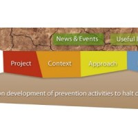 ABOT is one of the Pilot projects on Development of Prevention Activities to Halt Desertification in Europe, partly funded by DG Environment of the European Commission. The objective of the pilot projects is to support the development of concrete pilot initiatives on innovative technologies, techniques or practices in order to contribute to the exchanges of good practice and innovation for halting the desertification in ...
 Genova; Le Cinque Terre; Aulla; Messina: approfondimento sul tema delle alluvioni provocate da fenomeni meteorologici eccezionali.
Fausto Guzzetti interviene nella trasmissione "E se domani" di Alessandro Zanardi, andata in onda il 10 dicembre 2011 su RaiTre (a partire da 1:23:30 circa). Registrazione visualizzabile fino al 16 dicembre ... Dissesti idrogeologici, l’Italia sconta decenni di urbanizzazione selvaggia
Articolo di Gianluca Parnoffi pubblicato su Amaroma, a. 3, n. 2 (novembre 2011), pp- 22-23, contenente l'intervista a Fausto ... Liguria, il rischio-alluvione poteva essere ridotto con i soldi spesi per l’eolico
Articolo di Franco Battaglia pubblicato ne Il Giornale del 9 novembre ... Eventi calamitosi? È una vecchia storia…
Articolo di Anna Capasso pubblicato in Almanacco della Scienza n. 18 del ... Il Cnr risorsa per il Paese, anche nelle calamità
Editoriale di Francesco Profumo pubblicato in Almanacco della Scienza n. 18 del ... Intervista radiofonica a Fausto Guzzetti
 Intervista andata in onda nel programma Baobab di Rai RadioUno il 7 novembre 2011
[audio ...
Intervista andata in onda nel programma Baobab di Rai RadioUno il 7 novembre 2011
[audio ... Genova, negli ultimi 50 anni 103 morti per alluvioni e frane
Articolo da Repubblica.it ... Quelle mosse (impopolari) anti-alluvioni
Intervista a Fausto Guzzetti pubblicata su Il Secolo XIX del 5 novembre 2011, p. ... Trenta Minuti: ‘Campania da bollino rosso’
Intervista a Fausto Guzzetti andata in onda il 03/11/2011 sulla tramissione "Trenta Minuti" di Unis@und webradio
[audio ... Intervento di Fausto Guzzetti a UnoMattina in Famiglia del 29/10/2011
Intervista a Fausto Guzzetti durante il programma UnoMattina in Famiglia di Rai1 (a partire dal minuto 25 ... Alluvioni in Liguria, il cambiamento climatico non c’entra
Intervista di Marco Milano a Fausto Guzzetti pubblicata su scienzainrete.it (28 ootobre ... Intervista radiofonica a Fausto Guzzetti
Intervista durante il programma Baobab di Rai RadioUno del 27 ottobre 2011
[audio ... L’unica soluzione? Spostare le città delle zone a rischio”
Articolo apparso su La Stampa del 27 ottobre 2011, pag. 7, contenente l'intervista a Fausto ...