
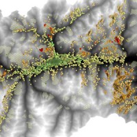
In Italy
The coloured circles represent the total number of activities (project, products and services, outreach, collaborations) that we have in the corresponding geographical zone
Map data: © OpenStreetMap contributors
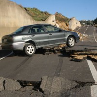
Maltempo, in Italia in 50 anni 500 inondazioni hanno provocato 1.760 vittime
 Articolo contenente dati del CNR-IRPI pubblicato nel sito de Il Fatto Quotidiano il 3 agosto ...
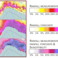
 L’algoritmo della pioggia per prevedere frane e alluvioni
Intervista pubblicata il 4 luglio 2014, sul sito web del quotidiano il CORRIERE DELLA SERA, riguardante l'algoritmo SM2RAIN per stimare la pioggia da dati di contenuto d’acqua satellitari a seguito della citazione su Nature (http://dx.doi.org/10.1038/509262e) della seguente pubblicazione:
Brocca, L., Ciabatta, L., Massari, C., Moramarco, T., Hahn, S., Hasenauer, S., Kidd, R., Dorigo, W., Wagner, W., Levizzani, V. (2014). Soil as a natural ... Innovative technologies at high environmental sustainability in the forest-based sector
 Millennium Ecosystems Assessment (ONU). Intergovernmental Convention on Climate and European Convention on the Protection of Forests. Integration of ground and remote technologies for Earth Observation and development of multi-resolution (spectral, spatial and temporal). Sustainable Forest Management (Ministerial Conference on the Protection of Forests in Europe). Decision support systems in the forest sector. Industrial technologies of the ...
 Spectral signatures library for semi-automatic event landslide recognition and mapping
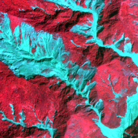 Earthquakes and strong rainfall precipitations, cause worldwide landslide. Inventories of the ground effects of an event must be prepared in a few days or less for the residual risk management. Satellite images and image analysis techniques have started to back up traditional mapping methods. Purpose of this project is to increase the automatization of image ...
 Scarpino, emergenza passata ma situazione rimane sotto esame
 Fausto Guzzetti parla della discarica di Scarpino (GE) nel servizio andato in onda su Tele Nord il 12 giugno ...
 Cambiamenti climatici, frane e inondazioni
Paola Salvati e Fausto Guzzetti parlano di dissesto idrogeologico nella puntata di Nautilus dedicata ai cambiamenti climatici, andata in onda il 5 giugno 2014 su Rai ... Debris flow of July 18, 2013 in the Gadria monitoring site
Il video youtube, a cura della 'Ripartizione Opere Idrauliche' della Provincia Autonoma di Bolzano, presenta una colata detritica registrata da una videocamera della stazione di monitoraggio del bacino del Rio Gadria (Vinschgau - Val Venosta) il 18 luglio 2013. Il CNR IRPI collabora dal 2010, anno di installazione della stazione, con la Ripartizione Opere Idrauliche, la Libera Università di Bolzano e l’Università di Padova alle attività di ... TG2 del 4 maggio 2014, edizione delle 20:30
Servizio nel quale si parla di alluvioni con il direttore del CNR-IRPI Fausto ... Marche, territorio fragile per frane e inondazioni
Articolo pubblicato nel sito del Corriere Adriatico il 4 maggio ... Maltempo: nelle Marche 10 grandi alluvioni negli ultimi 50 anni
Articolo pubblicato da meteoweb.eu il 4 maggio ... Renzi: “Impegno del governo dopo la conta danni”
Articolo pubblicato nel sito de Il Fatto Quotidiano il 4 maggio ... Inondazioni storiche nelle Marche
TGR Marche del 4 maggio 2014, edizione delle 19:30. Dal minuto 13:30 il servizio che parla delle inondazioni accadute nella regione Marche dal 1807 (dati ... Mountains fall down
 Radio interview (23/04/2014) to Daniele Giordan and Silvia Peppoloni by Rosella Panarese.
An active landslide of four hundred thousand cubic meters menaced to fall down from the Mont de la Saxe, near Courmayeur. Dozens of people evacuated, waiting for the landslide collapse. A continuous monitoring system that closely control the instable are evolution. Daniele Giordan, Research Institute for the hydrogeological Protection of the CNR of Turin, ...
Radio interview (23/04/2014) to Daniele Giordan and Silvia Peppoloni by Rosella Panarese.
An active landslide of four hundred thousand cubic meters menaced to fall down from the Mont de la Saxe, near Courmayeur. Dozens of people evacuated, waiting for the landslide collapse. A continuous monitoring system that closely control the instable are evolution. Daniele Giordan, Research Institute for the hydrogeological Protection of the CNR of Turin, ... In Courmayeur a complex active landslide linked to the recent evolution of a larger slope instability
La Repubblica, Italian newspaper, 22/04/2014.
Interview with Daniel Giordan on the recent evolution of the landslide of the Mont de La Saxe and related ... Connecting European Connectivity Research
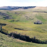
 Water and sediment connectivity has emerged in recent years as a significant conceptual framework for understanding the transfer of surface water and sediment through landscapes. Connectivity can be seen both as a driver of hydrological and geomorphic processes within a catchment and as an emergent catchment property that is the result of processes acting at different ...
 Intervista di F. Guzzetti a Radio3 Scienza
Intervento del direttore del CNR-IRPI Fausto Guzzetti in apertura della puntata del 26 marzo 2014 di Radio3 Scienza - quotidiano scientifico della terza rete.
[audio ... Investigations for the mitigation of geo-hydrological risk along the railway “Eccellente – Rosarno”
 Large part of the territory is affected by geomorphological instability, often threatening the anthropic environment. Technical and socio-economic reasons often impose coexistence with the risks. Therefore, appropriate risk mitigation and/or reduction strategies must be implemented. Field and laboratory investigations, monitoring, modelling techniques and cartographic analyses are essential tools to acquire the necessary ...
 20 years of continuous SAR observations benefit landslide studies
The European Space Agency (ESA), Earth Online web site (https://earth.esa.int/web/guest/pi-community/results) has picked and commented positively one of our latest papers published recently in the journal Remote Sensing of Environment 142 (2014), doi:10.1016/j.rse.2013.11.003. The paper deals with the exploitation of the ESA SAR data for the long-term monitoring of the Ivancich active landslide, Assisi, central ...
ITTS Volta e CNR IRPI per il futuro del monitoraggio idrogeologico
Articolo sulla Giornata di Studio CNR IRPI e ITTS A. Volta di Perugia tenutasi l'8 marzo 2014, pubblicato nel sito http://www.umbriajournal.com a firma Maria Cristina ... Rainfall thresholds for the possible initiation of rainfall-induced landslides in Apulia
 In Italy rainfall are among the main causes of trigger of shallow landslides, that yearly cause fatalities, damage, and severe economic losses. Identification of the amount of rainfall needed to trigger landslides, and the forecasting of rainfall-induced landslides, are of interest for the scientific community, as well as for the whole ...
 La cura che manca all’Italia dei disastri. Le frane sono 13 volte quelle dell’800
Articolo di Gian Antonio Stella, pubblicato sul Corriere della Sera del 2 febbraio 2014, contenente dati e mappe prese dal sito ... Instability problems related to man-made cavities in the Municipality of Ginosa
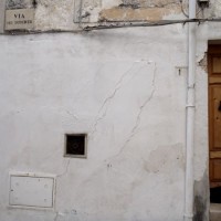
 The territory of Ginosa was severely affected by flood and instability problems in October and in December 2013, as many other municipalities at the boundary between Apulia and Basilicata. In particular, on October 7, 2013, four fatalities and serious damage had to be registered. Following these events, other instabilities have occurred, including the collapse of a stretch of Via Matrice, above artificial cavities, on January 21, ...
 Informatica. La ricerca Cnr apre nuovi portali
Articolo a pubblicato ne L'almanacco della scienza N. 2 del 29 gennaio ... TG2 Insieme (23 gennaio 2014)
Il direttore del CNR-IRPI dott. Fausto Guzzetti ospite del programma TG2 Insieme parla di rischio idrogeologico. Il suo intervento a partire dal minuto 11 circa.
[video width="320" height="240" ... RelationsHips between meteo-climAtic paraMeters and ground surface deforMation time sEries in mountain enviRonments
 There is a systematic lack of information on the effects of the climate and environmental changes on the frequency and the intensity of landslides and their triggering phenomena (Huggel et al., 2012). The problem is particular severe in mountain area, where natural and human-driven climatic and environmental changes may alter significantly the frequency and the intensity of the slope processes, with largely unknown short and long-term effects ...
 Ventennale dell’Alluvione in Piemonte del 1994
 Nel 2014 ricorrono vent’anni dalla tragica alluvione che nel novembre 1994 colpì gran parte del territorio piemontese, con perdita di vite umane, di beni mobili ed immobili. L’alluvione 1994 costituì altresì un momento storico nel campo della pianificazione territoriale, prevenzione e gestione della pericolosità e rischio geologico-idraulico, che si tradusse in dettami normativi, per l’epoca avanzati e lungimiranti. Da quell’evento ...
 Gestione dei Sedimenti Fluviali
 Il progetto GeSeFlu nasce dalla necessità della Regione Lombardia mediante il Piano Operativo Regionale (Direttiva Comunitaria 2000/60/CE) di disporre di specifici Programmi di Gestione dei sedimenti per i sottobacini redatti in attuazione della Direttiva del Comitato Istituzionale dell’Autorità di Bacino del fiume Po (deliberazione n. 9 del 5 aprile ...
 Analysis of instabilities in the historical centre of Mesagne
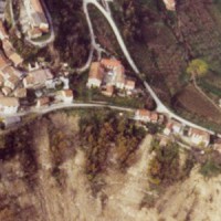
 The instabilities that affected the historical part of Mesagne (Brindisi province, Apulia) since January 21, 2014, induced the local Authority to issue evacuation decrees for 18 families, corresponding to a total of 26 people. CNR IRPI was asked to provide scientific support for the identification of the processes at the origin of the ...
 Mobile Application for Emergency Response and Support
 The responsibilities within natural hazards involve citizens and volunteers as first actors of civil protection. The prevention implicates technical volunteers, but the priority implies now awareness of local citizens. The involvement of population creates context-specific strategies of territorial surveillance and management. MAppERS empowers “crowd-sourced mappers” through smart phone applications and sensors, with geo-tagged information, ...
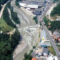
 The 3 December 2013 Montescaglioso landslide
 On December 3, 2013, a large landslide activated on the SW slope of Montescaglioso (Matera province, Basilicata), affecting an area with evidence of past instability. The landslide involved some 500 m of the main road to the village, and also interested several houses and other ...
 Lo studio del CNR sugli ultimi 60 anni. In Sardegna le inondazioni fanno più vittime che nel resto d’Italia
Articolo a firma Cristiana Pulcinelli pubblicato ne L'Unità del 20 novembre 2013 contenente l'intervista a Paola ... Prima di tutto
Dal minuto 7:30 circa intervista a Fausto Guzzetti durante la trasmissione Prima di tutto di Rai RadioUno, andata in onda il 20 novembre 2013. (Stralcio della puntata)
[audio ... L’Italia un territorio fragile. I numeri del dissesto idrogeologico
 Progetto interattivo de La Stampa, a cura di Paolo Bernocco e Lidia Catalano, realizzato anche con i dati del ...
 Cnr: sulla Sardegna alta mortalità per inondazioni
Articolo pubblicato nel sito de La Nuova Sardegna il 19 novembre ... Vittime delle alluvioni (1960-2012)
Infografica pubblicata nel sito ANSA il 19 novembre ... Solo sulla carta
Podcast della puntata del 20 novembre di Radio3 Scienza - quotidiano scientifico della terza rete, contenente l'intervista a Paola Salvati (dal minuto 2:15 circa)
[audio ... Tra 1960 e 2012 in Italia 541 inondazioni e 812 frane, oltre 4mila i morti
Articolo pubblicato da Adnkronos.com il 9 ottobre ... 1963-2013: anniversario del disastro del Vajont
Intervento della dott.ssa Paola Salvati nello spazio dedicato al 50° anniversario del disastro del Vajont, andato in onda durante la puntata del 9 ottobre 2013 di Geo&Geo (Rai3).
[video width="512" height="288" ... SANF Liguria
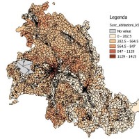
 In Italy, landslides are triggered by intense and/or prolonged rainfall. The spatial and temporal forecast of multiple landslides triggered by rainfall in wide areas relies primarily on empirical rainfall thresholds. It is widely believed that the thresholds are influenced by the local topographic (morphological), lithological, soil, and climatic settings. For this reason, it is necessary to define local rainfall thresholds. Reliable local ...
 Cost of Natural Hazards in Italy
 Economic analysis has produced a set of analysis on natural disasters to measure the impacts of the events, the possibility of insurance schemes, and the optimization of prevention policies. In Italy these economic analysis are not widespread and the information on damage is limited. The available estimates are limited to the public money spent for post-event reconstruction and do not correspond to the total social ...
 Advanced and Integrated Monitoring of Earth DAMS
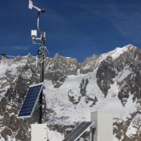
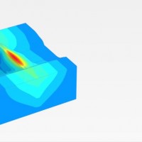 The project AIM-DAMS is aimed at developing a laboratory of integrated and advanced environmental monitoring for the control of the behavior of the earth-dams due to the different factors acting on the dams during their lifetime. Based on the integration of innovative and non-invasive sensors, as well as recent monitoring techniques and numerical modelling, the project is intended to fulfill the need of the dam management agencies of using ...
 Analysis and monitoring of Planpincieux Glacier, Monte Bianco massif (AO)
 The Planpincieux Glacier is one of the glaciers that characterize the Italian side of the massif of the Grandes Jorasses. It is considered a temperate glacier and its front is currently located near a morphological step that determines a strong propensity to the activation of frequent ice falls in particular during the summer. These phenomena are typical of this glacier, but its particular asset may cause, as already occurred in the past, to ...
 Terra Fragile
Reportage di Donato Placido trasmesso nella puntata di Tg2 Dossier del 6 luglio 2013. Dal minuto 50:50 circa descrizione delle attività del CNR-IRPI e intervista a Fausto Guzzetti.
[video width="320" height="240" ... DORIS Fourth Dissemination Meeting, Foligno, 20 giugno 2013
Servizio di Luciana Barbetti andato in onda nel TGR Umbria del 20 giugno 2013
[video width="480" height="320" ... Forum Scienza, Responsabilità e Governo
E' disponibile su YouTube il filmato del Forum Scienza, Responsabilità e Governo: La conoscenza scientifica per un approccio etico nella società del rischio organizzato da EcoScienza, rivista di ARPA Emilia-Romagna.
Al Forum ha partecipato con un intervento Fausto Guzzetti.
L'intervento di FG è da 2:31:00 - 2:48:00, e da 3:21:30 a ... Stability analysis in the Fantiano quarries
 The Fantiano quarries at Grottaglie (Taranto province) are an ancient sector of extraction of the local calcarenite rock, that is now used for concerts and shows. The instability phenomena observed in the quarries forced the Municipality of Grottaglie to ask to CNR-IRPI to perform stability analyses in the ...
 Scienza, Responsabilità e Governo
Il 12 giugno 2013, la rivista Ecoscienza, dell'ARPA Emilia-Romagna, ha organizzato un workshop sul tema Scienza, Responsabilità e Governo. Sono oggi disponibili nel sito della rivista (http://issuu.com/ecoscienza/docs/ecoscienza4_2013) gli interventi fatti al workshop, tra cui quello di F. ... Spatial-temporal evolution of glacial resources in the Italian Alps over the last 100 years
 Glaciers are widely recognized as the best terrestrial indicator of climate change. Nevertheless, occurred changes, even in recent times, are often poorly known. Italy has a unique, secular history of glaciological documentation that, jointly with a rich wealth of spatial, multitemporal data, allows an accurate reconstruction of recent glacier evolution. Unfortunately, these data are dispersed and/or difficult to ...
 Landslide maps for the Castelfranci municipality
 Castelfranci (Avellino, Campania) is located in the catchment of the Calore River, in correspondence of a N-S oriented stretch of the river. This territory is intensely affected by landslide development, which more than once was in the past at the origin of severe damage to the local community, and heavy losses to ...
 I sensori della Concordia per salvare San Giovanni
Articolo pubblicato nel Messaggero (Umbria) l'8 maggio 2013 che descrive le attività di monitoraggio della frana in località S. Giovanni Profiamma, nel Comune di Foligno (PG), che ha causato la chiusura della S.S. 3 Flaminia. Il Gruppo di Geomonitoraggio dell'Istituto ha installato una stazione totale robotizzata per il monitoraggio della ...