
Liguria
The coloured circles represent the total number of activities (project, products and services, outreach, collaborations) that we have in the corresponding geographical zone
Map data: © OpenStreetMap contributors
Prediction of Rainfall-INduced landslides – Improving multi-scale TerritoriAL Early warning through aRTificial intelligence
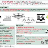 Predicting the occurrence of rainfall-induced landslides is a crucial task for civil protection purposes. Several landslide early warning systems are currently operating worldwide at different spatial scales. In Italy, landslide alerts are issued for territorial units named Alert Zones, covering a few thousand km². Usually, regional-scale warning models rely on rainfall thresholds, which require a few parameters and provide clear results in ...
 I-CHANGE project
Automated Inclinometer System (AIS) for deep-seated ground deformation measurements
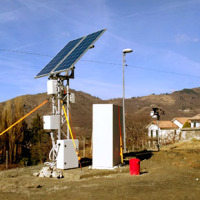
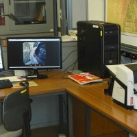
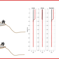 Our AIS (Automated Inclinometer System) allows for fully automatic inclinometer measurements in standard boreholes. The deep measurements have multiple applications, including (i) evaluating the rate of deep-seated ground deformation in landslide areas, (ii) evaluating the volume of deep-seated landslides, and (ii) assessing landslide hazards.
The AIS is composed of an electronic control manager, an inclinometer probe (with traditional ...
Our AIS (Automated Inclinometer System) allows for fully automatic inclinometer measurements in standard boreholes. The deep measurements have multiple applications, including (i) evaluating the rate of deep-seated ground deformation in landslide areas, (ii) evaluating the volume of deep-seated landslides, and (ii) assessing landslide hazards.
The AIS is composed of an electronic control manager, an inclinometer probe (with traditional ... Progetto ADAPT
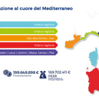 The ADAPT project, co-funded by the Interreg Italy-France Maritime Program 2014-2020, aims to adapt the Italian and French cities of the Upper Tyrrhenian to the consequences of climate change, with particular reference to the urban flash floods caused by intense meteorological ...
 Agreement with the Ligurian Regional Agency for Environmental Protection (ARPAL)
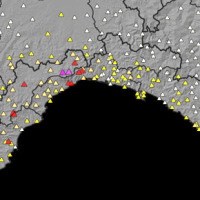 Since 2013, CNR IRPI went in with the collection of information on rainfall events that have resulted in landslides in the Liguria region. Rainfall thresholds can be used in early warning systems for the prediction of the occurrence of rainfall-induced landslides. To respond to a request of the Italian national Department for Civil Protection (DPC), CNR IRPI designed and developed SANF, an Italian acronym for National Early Warning System for ...
 Regenarating ECOsystems with Nature-based solutions for hydro-meteorological risk rEduCTion
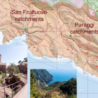 RECONECT is a Horizon 2020 project that aims to enhance the European reference framework on Nature Based Solutions (NBS) for hydro-meteorological risk reduction by demonstrating, referencing, upscaling and exploiting large-scale NBS in rural and natural areas. The Pilot site is the Portofino Natural Regional Park (Ligurian Apennines), 25 km E of Genoa. The park extends along both sides of the Promontory of Portofino, facing Tigullio and ...
 Study and monitoring activities on Arzeno landslide – Municipality of Ne (GE)
 The Municipality of Ne (GE) is involved by an important landslide in the Arzeno and Prato di Reppia areas. The phenomenon is monitored using standard techniques for some years. The goals of this study is increasing the knowledge of the phenomenon using automatic monitoring ...
 Geomorphometry and sediment dynamics in mountain catchments
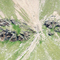
 The aim of the geomorphometric analysis is to derive indices capable of characterizing the spatial variability of specific hydro-geomorphological processes (e.g., sediment connectivity, erosion and deposit). The growing availability of high-resolution topographic data has increased the interest in geomorphometry and its applications. Debris-flow monitoring in instrumented areas and flash-flood documentation are invaluable ways to gather field ...
 Safe Landscapes: prevention and adaptation strategies
 The project aims at defining the type of expected natural hazards, the modeling approaches relevant for their evaluation, and possible monitoring tools in specific areas prone to landslide risk within the "UNESCO site Portovenere, Cinque Terre and the Islands (Palmaria, Tino and Tinetto)" along the "Blue Trail" from Monterosso through ...
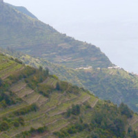
 I terrazzamenti nel Tigullio: storia, ambiente e rischio idrogeologico
 Presentato a Lavagna il concorso letterario "I terrazzamenti nel Tigullio: storia, ambiente e rischio idrogeologico". Rivolto alle scuole di ogni ordine e grado presenti sul territorio, il concorso si inserisce nelle attività legate al convegno “Paesaggi Terrazzati: scelte per il futuro”, che si terrà a Padova dal 6 al 15 ottobre 2016, e che vede IRPI tra gli organizzatori.
Vai all'articolo ...
Presentato a Lavagna il concorso letterario "I terrazzamenti nel Tigullio: storia, ambiente e rischio idrogeologico". Rivolto alle scuole di ogni ordine e grado presenti sul territorio, il concorso si inserisce nelle attività legate al convegno “Paesaggi Terrazzati: scelte per il futuro”, che si terrà a Padova dal 6 al 15 ottobre 2016, e che vede IRPI tra gli organizzatori.
Vai all'articolo ... Mappatura, Modellazione e Previsione Multiscala dei RIschi GEo-idroLogici
 Italy has a tradition of scientific research and technological development on hazardous natural phenomena in general, and specifically on geo-hydrological hazards. Within the CNR, the “Progetti Finalizzati” Soil Conservation and Geodynamics (in the ’70s and ’80s), and GNDCI – the National Group for the Defence from Hydrogeological Disasters (in the ’80s and ’90s), have contributed to the advancement of knowledge ...
 Un Paese nel fango. Frane, alluvioni e altri disastri annunciati. I fatti, i colpevoli, i rimedi
Nel quarto capitolo 'Il fango nella politica' del libro 'Un Paese nel fango. Frane, alluvioni e altri disastri annunciati. I fatti, i colpevoli, i rimedi' di D'Angelis Erasmo, è riportata un'affermazione di Fabio Luino, ricercatore presso l'Istituto di Ricerca per la Protezione Idrogeologica, in merito al rischio idrogeologico a ... Aerofototeca
 The CNR IRPI archive preserves 170.000 aerial photographs useful for stereoscopic applications. Most part of those photographs were taken during a number of surveys carried out between 1954 and 2005 in tha Padan Plain, Triveneto and Liguria (Northern Italy) but some examples date from the 1920s, 1930s and 1940s.
In this documentation the effects of many floods and landslides events can be observed. In particular, we would mention the aerial ...
The CNR IRPI archive preserves 170.000 aerial photographs useful for stereoscopic applications. Most part of those photographs were taken during a number of surveys carried out between 1954 and 2005 in tha Padan Plain, Triveneto and Liguria (Northern Italy) but some examples date from the 1920s, 1930s and 1940s.
In this documentation the effects of many floods and landslides events can be observed. In particular, we would mention the aerial ... Alluvioni, incubo dei sindaci liguri. Ed è polemica sulle scuole chiuse
 Articolo pubblicato su Repubblica, edizione Genova, il 4 marzo ...
 In cinquanta anni in Liguria morte centoventi persone per frane e alluvioni
Articolo pubblicato nel Corriere Mercantile il 4 marzo ... Il bilancio delle alluvioni che rende la Liguria la seconda regione in Italia per numero di vittime
 Servizio di Primocanale news, edizione delle ore 13, andato in onda il 3 marzo 2015, in cui sono stati citati i dati forniti dall' IRPI-CNR.
[video width="320" height="240" ...
Servizio di Primocanale news, edizione delle ore 13, andato in onda il 3 marzo 2015, in cui sono stati citati i dati forniti dall' IRPI-CNR.
[video width="320" height="240" ... Prevenire le frane, Liguria capofila di un progetto del Cnr
Intervista trasmessa da Primocanale News a Fausto Guzzetti, direttore dell'Istituto di Ricerca per la Protezione Idrogeologica del CNR, in occasione del convegno “La responsabilità del sindaco nella protezione civile”, tenutosi a Genova il 3 marzo ... CNR-IRPI: in Liguria frane e inondazioni causano 120 vittime in 50 anni
Il TG di TeleGenova del 3 marzo 2015, edizione delle 19.15, cita i dati del CNR-IRPI.
[video width="320" height="240" ... CNR-IRPI: in 50 anni il dissesto idrogeologico ha causato in Liguria 120 morti
 Il GR regionale della Liguria del 3 marzo 2015, edizione delle 12.10, cita i dati del CNR-IRPI.
[audio ...
Il GR regionale della Liguria del 3 marzo 2015, edizione delle 12.10, cita i dati del CNR-IRPI.
[audio ... Civil Protection Competence Centre on Geo-Hydrological Risk
 In Italy landslides and floods are frequent, widespread and dangerous phenomena, that cause fatalities and serious economic damage. In our country, landslides and floods pose major problems of scientific interest and of social and economic relevance.
The Institute is a Competence Centre for the Italian national Civil Protection Department, an Office of the Prime Minister. For the Department of Civil Protection we execute research and ...
In Italy landslides and floods are frequent, widespread and dangerous phenomena, that cause fatalities and serious economic damage. In our country, landslides and floods pose major problems of scientific interest and of social and economic relevance.
The Institute is a Competence Centre for the Italian national Civil Protection Department, an Office of the Prime Minister. For the Department of Civil Protection we execute research and ... Puntata di “Caterpillar” del 17/11/2014 – Rai Radio 2
Intervista a Fabio Luino durante la trasmissione "Caterpillar" andata in onda il 17/11/2014 su Rai Radio 2, riguardante l'alluvione in Liguria. Dal minuto ... Contro i disastri in campo il Cnr ma in Liguria nessuno se ne accorge e in 44 anni si piangono 100 morti
Articolo firmato Marco Preve pubblicato nel sito di Repubblica, edizione di Genova, il 4 novembre ... L’alluvione di Genova
Unomattina del 13 ottobre 2014. Dal minuto 19:25 circa Paola Salvati interviene nello spazio dedicato all'evento di Genova
[video width="512" height="288" ... Liguria, terra maledetta di disastri idrogeologici. Il primo evento risale al 1646
Articolo di Paola Salvati pubblicato ne Il Garantista il 12 ottobre ... Cnr: Liguria tra le regioni più colpite da frane e alluvioni. Dal 1970 oltre 100 tra morti e dispersi
Articolo pubblicato nel sito di Rainews il 10 ottobre ... Scarpino, emergenza passata ma situazione rimane sotto esame
Fausto Guzzetti parla della discarica di Scarpino (GE) nel servizio andato in onda su Tele Nord il 12 giugno ... TG2 Insieme (23 gennaio 2014)
Il direttore del CNR-IRPI dott. Fausto Guzzetti ospite del programma TG2 Insieme parla di rischio idrogeologico. Il suo intervento a partire dal minuto 11 circa.
[video width="320" height="240" ... SANF Liguria
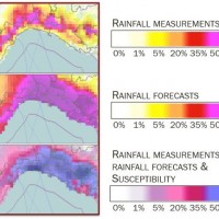 In Italy, landslides are triggered by intense and/or prolonged rainfall. The spatial and temporal forecast of multiple landslides triggered by rainfall in wide areas relies primarily on empirical rainfall thresholds. It is widely believed that the thresholds are influenced by the local topographic (morphological), lithological, soil, and climatic settings. For this reason, it is necessary to define local rainfall thresholds. Reliable local ...
 Landslide Modelling and tools for vulnerability assessment Preparedness and REcovery management
 Il progetto FP7 LAMPRE - Landslide Modelling and tools for vulnerability assessment Preparedness and Recovery management svolge attività di ricerca innovative e di sviluppo tecnologico per migliorare le capacità del sistema Copernicus di far fronte a eventi di frana e alle loro conseguenze, in Europa e in altre parti del mondo. LAMPRE migliora il rischio di frana sforzi di mitigazione / preparazione e le attività di recupero e di ...
 Geo-hydrological hazards in the Pogliaschina catchment
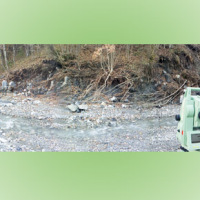
 The occurrence of flash floods in mountainous catchments is often associated to relevant geomorphic effects, both in the channel network (channel changes and transport of large wood), and on the hillslopes (landslides and soil erosion). The concomitance of flash floods, channel changes and landslides enhances hazards and risk associated to individual ...
 Genova; Le Cinque Terre; Aulla; Messina: approfondimento sul tema delle alluvioni provocate da fenomeni meteorologici eccezionali.
Fausto Guzzetti interviene nella trasmissione "E se domani" di Alessandro Zanardi, andata in onda il 10 dicembre 2011 su RaiTre (a partire da 1:23:30 circa). Registrazione visualizzabile fino al 16 dicembre ... Liguria, il rischio-alluvione poteva essere ridotto con i soldi spesi per l’eolico
Articolo di Franco Battaglia pubblicato ne Il Giornale del 9 novembre ... Genova, negli ultimi 50 anni 103 morti per alluvioni e frane
Articolo da Repubblica.it ... Alluvioni in Liguria, il cambiamento climatico non c’entra
Intervista di Marco Milano a Fausto Guzzetti pubblicata su scienzainrete.it (28 ootobre ...