
Theme: Mapping
Full cOveRage, Multi-scAle and multi-sensor geomorphological map: a practical tool for TerrItOrial plaNning
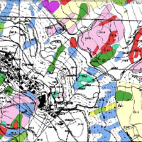
 Italy is an extremely fragile territory, widely exposed to hydrogeological hazards affecting anthropic infrastructures and the natural environment. In this scenario, geomorphological maps, including the representation of the spatial distribution of landforms, have been used for a long time for the description of processes acting on the Earth’s surface. Geomorphological maps should represent the basic tool for the assessment of ...
 How we map landslides
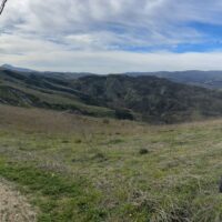
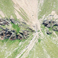
 A landslide is the movement of a mass of rock, debris or earth along a slope under the influence of gravity.
Landslides pose serious threats in many areas of the world, and knowing their location, distribution and classification is important for land use planning. Landslide identification and mapping is a fundamental activity for an effective defence from the damage caused by landslides to the population and to structures and the ...
A landslide is the movement of a mass of rock, debris or earth along a slope under the influence of gravity.
Landslides pose serious threats in many areas of the world, and knowing their location, distribution and classification is important for land use planning. Landslide identification and mapping is a fundamental activity for an effective defence from the damage caused by landslides to the population and to structures and the ... Integrated multi-scale methods for seismically induced landslide hazard zonation
 The research activity aims at defining a coherent and unambiguous framework for the assessment and zonation of seismically induced landslides, at different geographical, temporal and management scales. To this end, the project works at the pre-event temporal scale, concerning spatial planning and soil protection and corresponding to years to decades time periods, and at the real-time or civil protection scale, corresponding to time periods ...
 SaTellite based Runoff Evaluation And Mapping
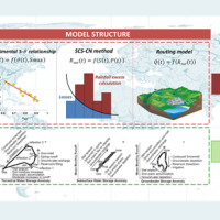 Water is at the centre of economic and social development; it is vital to maintain health, grow food, manage the environment, and create jobs. As well over half of the world’s potable water supply is extracted from rivers, either directly or from reservoirs, understanding the variability of the stored water on and below landmasses, i.e., total runoff, is of primary importance. In situ observations or land surface/hydrological models are ...
 Crowdmapping of earthquake induced rock falls
 Making reports of rockfall in the area affected by the earthquake in central Italy in ...
 SLOPES
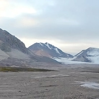 This project is embedded within the framework of the three Ny-Ålesund flagships: ‘Kongsfjorden system’, ‘Glaciology’ and ‘Terrestrial system’. The study of slopes and landscape modifications under a changing climate, is needed to understand the dynamic interaction between the cryosphere, hydrosphere, geosphere and biosphere, and how geosuccession and biosuccession (colonisation) processes develop over time. Records of landscape ...
 Threedimensional Displacement Analysis
 The 3DA software is a new procedure that allows retrieving in near-real-time 3D surface deformation models starting from data acquired via robotized total stations or others system that acquire the surface displacements. The measurements are first pre-processed and then implemented on 3D maps that include vector arrows representative of the intensities and of the real directions of motion in a given system of coordinates. The 3D surface ...
 Mappatura, Modellazione e Previsione Multiscala dei RIschi GEo-idroLogici
 Italy has a tradition of scientific research and technological development on hazardous natural phenomena in general, and specifically on geo-hydrological hazards. Within the CNR, the “Progetti Finalizzati” Soil Conservation and Geodynamics (in the ’70s and ’80s), and GNDCI – the National Group for the Defence from Hydrogeological Disasters (in the ’80s and ’90s), have contributed to the advancement of knowledge ...
 Sediment Connectivity Assessment
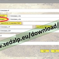 SedInConnect is a stand-alone application for the computation of the Sediment Connectivity Index (Cavalli et al., 2013, Crema et al., 2015).
The software has been developed in the frame of the SedAlp project, funded by the Alpine Space Programme (European Territorial Cooperation 2007-2013)
The output of the applied model is a topography-based index aiming at evaluating the potential connection between hillslopes and features acting as targets ...
SedInConnect is a stand-alone application for the computation of the Sediment Connectivity Index (Cavalli et al., 2013, Crema et al., 2015).
The software has been developed in the frame of the SedAlp project, funded by the Alpine Space Programme (European Territorial Cooperation 2007-2013)
The output of the applied model is a topography-based index aiming at evaluating the potential connection between hillslopes and features acting as targets ... Upper-middle Tiber river basin: the flood event of 25-28 november 2005
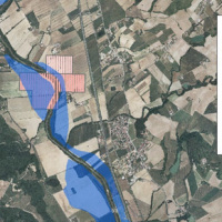 On 25-27 November 2005, the territory of central Italy was affected by heavy rainfall that hit the Tiber River basin and, mainly, the province of Perugia. The meteoric event had a significant phase with a duration of approximately 48 hours with widespread precipitation up to a maximum accumulated value higher than 100 mm. Significant increases in water levels occurred in most rivers of Upper-Middle Tiber
causing extended flooding in ...
On 25-27 November 2005, the territory of central Italy was affected by heavy rainfall that hit the Tiber River basin and, mainly, the province of Perugia. The meteoric event had a significant phase with a duration of approximately 48 hours with widespread precipitation up to a maximum accumulated value higher than 100 mm. Significant increases in water levels occurred in most rivers of Upper-Middle Tiber
causing extended flooding in ... Civil Protection Competence Centre on Geo-Hydrological Risk
 In Italy landslides and floods are frequent, widespread and dangerous phenomena, that cause fatalities and serious economic damage. In our country, landslides and floods pose major problems of scientific interest and of social and economic relevance.
The Institute is a Competence Centre for the Italian national Civil Protection Department, an Office of the Prime Minister. For the Department of Civil Protection we execute research and ...
In Italy landslides and floods are frequent, widespread and dangerous phenomena, that cause fatalities and serious economic damage. In our country, landslides and floods pose major problems of scientific interest and of social and economic relevance.
The Institute is a Competence Centre for the Italian national Civil Protection Department, an Office of the Prime Minister. For the Department of Civil Protection we execute research and ... Spectral signatures library for semi-automatic event landslide recognition and mapping
 Earthquakes and strong rainfall precipitations, cause worldwide landslide. Inventories of the ground effects of an event must be prepared in a few days or less for the residual risk management. Satellite images and image analysis techniques have started to back up traditional mapping methods. Purpose of this project is to increase the automatization of image ...
 Increasing Resilience through Earth Observation
 To significantly contribute to the operational capacities in the context of Global Monitoring for Environment and Security (GMES)/ Copernicus by developing customised mapping and geo-information products addressing risk, vulnerability and assets ready for deployment in the prevention and preparedness phases – complementary to the GMES/Copernicus Emergency Management Service. Solutions to be provided are based for the most part on Earth ...
 Extraterrestrial landslides
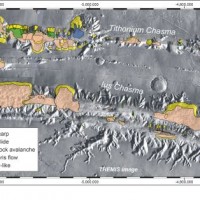 Landslides play an important role in the evolution of landscapes on Earth and on other solid planets of the Solar System. Surface gravity is the main factor driving landslides in solid planets. On Earth, landslides have been recognized in all continents, and in subaerial and submarine environments. The spatial and temporal range of the observed slope failures is extremely large on Earth. We are conducting a systematic mapping of landslides in ...
 Cassini Extended Mission
The project, funded by ASI under the coordination of INAF (Istituto di Astrofisica Spaziale), involved Italian research groups active in data analysis from Cassini-Huygens probe, orbiting around Saturn and its ...