
In the World
The coloured circles represent the total number of activities (project, products and services, outreach, collaborations) that we have in the corresponding geographical zone
Map data: © OpenStreetMap contributors
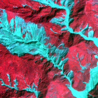
Land cover change detection and monitoring methodologies based on the combined use of S1 and S2 for natural resources and hazard management
 ESA Sentinels missions will provide enhanced capabilities in the revisit frequency, and the coverage. Their complete exploitation is in the combination of the two to advantage of a further increased revisiting time and in the use of different wavelenght domains. This reflects in the capabilities to detect features of changes induced by different factors including natural hazards and crop ...
 H-SAF and GPM: precipitation algorithm development and validation activity
 The proposal intends to contribute towards the establishment of a long-term partnership between the EUMETSAT Satellite Application Facility on support to Operational Hydrology and Water Management (H-SAF, or Hydrology SAF) and the NASA/JAXA Global Precipitation Measurement (GPM) ...
 Spectral signatures library for semi-automatic event landslide recognition and mapping
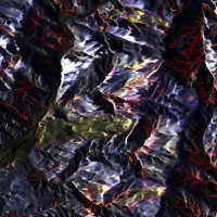
 Earthquakes and strong rainfall precipitations, cause worldwide landslide. Inventories of the ground effects of an event must be prepared in a few days or less for the residual risk management. Satellite images and image analysis techniques have started to back up traditional mapping methods. Purpose of this project is to increase the automatization of image ...
 Connecting European Connectivity Research
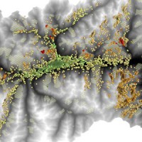
 Water and sediment connectivity has emerged in recent years as a significant conceptual framework for understanding the transfer of surface water and sediment through landscapes. Connectivity can be seen both as a driver of hydrological and geomorphic processes within a catchment and as an emergent catchment property that is the result of processes acting at different ...
 RelationsHips between meteo-climAtic paraMeters and ground surface deforMation time sEries in mountain enviRonments
 There is a systematic lack of information on the effects of the climate and environmental changes on the frequency and the intensity of landslides and their triggering phenomena (Huggel et al., 2012). The problem is particular severe in mountain area, where natural and human-driven climatic and environmental changes may alter significantly the frequency and the intensity of the slope processes, with largely unknown short and long-term effects ...
 Florida forecasts sinkhole burden
 Articolo pubblicato su NATURE, vol. 504, 12 december 2013, p. 196-197, in cui si cita il lavoro dell'IRPI sui sinkholes in ...
 Landslide Modelling and tools for vulnerability assessment Preparedness and REcovery management
 Il progetto FP7 LAMPRE - Landslide Modelling and tools for vulnerability assessment Preparedness and Recovery management svolge attività di ricerca innovative e di sviluppo tecnologico per migliorare le capacità del sistema Copernicus di far fronte a eventi di frana e alle loro conseguenze, in Europa e in altre parti del mondo. LAMPRE migliora il rischio di frana sforzi di mitigazione / preparazione e le attività di recupero e di ...
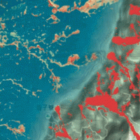
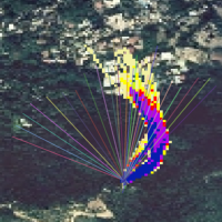
 SAR change detection methodologies for event landslide mapping
 The project explores and implements multi-scale and multi-sensor SAR change detection methodologies for event landslide mapping. Automated analysis for change detection is a challenging task due
to the inherent noisiness of SAR imagery and also to the high sensitivity to texture variability due to different acquisition angles. Moreover, pre-processing (de-speckling) may lead to the degradation
of the geometrical details and affect the ...
The project explores and implements multi-scale and multi-sensor SAR change detection methodologies for event landslide mapping. Automated analysis for change detection is a challenging task due
to the inherent noisiness of SAR imagery and also to the high sensitivity to texture variability due to different acquisition angles. Moreover, pre-processing (de-speckling) may lead to the degradation
of the geometrical details and affect the ... Alarm and monitoring systems for debris and mud flows
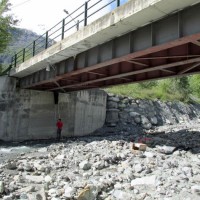 Monitoring of debris flows in instrumented areas is carried out since many years in different Countries worldwide. It is still missing, however, an adequate standardization of methodologies, instrumentations and procedures. The instrumented areas are also employed for testing warning systems. Even though these latter have been more and more employed, a systematic experimentation of these systems has not yet been carried ...
 Spatially distributed modelling of landslide phenomena
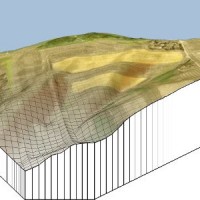 The application of distributed physically based models is possible on relatively small areas, typically hundreds or few thousands of km2. Distributed modelling of slope dynamics requires many sufficiently detailed information. Knowledge of geotechnical parameters and land use, digital terrain models, medium/high resolution cartography, temporal evolution of soil moisture conditions, are ...
 Rainfall, seismicity, landslides and sediment discharge in mountain belts
 Taiwan, an active orogenic belt with subtropical climate is characterized by a high uplift rate and several major typhoons each year. Italy is on one of the most seismically active regions in Europe because of the thrust of African plate on Eurasian continental one. Both experience numerous landslides along with earthquakes and intense rainfalls, causing heavy damages and casualties. The purpose of this project was to share scientific knowledge ...
 Karst sinkholes in urban areas in Florida
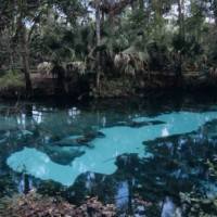 Sinkholes are among the main features of karst areas, and are extremely widespread in Florida, one of the sites most known for their occurrence and the likely interaction with the built-up environment. The Tampa area, in turn, shows an high frequency of events, which origin derives from different types of ...
 High pressure rheology
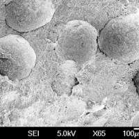 Some geological phenomena of high pressure shearing show an unusual low friction during rock on rock slipping, like the abnormally long rock avalanches runout (hypermobility) or the slip of faults during earthquakes. The project aims to study the effect of the dynamic fragmentation of rock granules on the motion shear resistance, starting from the consideration that dynamic fragmentation is ubiquitous in geological processes subject to shearing ...