
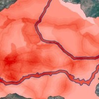
In Europe
The coloured circles represent the total number of activities (project, products and services, outreach, collaborations) that we have in the corresponding geographical zone
Map data: © OpenStreetMap contributors
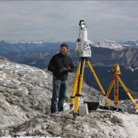
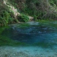
Zermatt (CH), Test site of DORIS project
 Interview with Fausto Guzzetti and Hugo Raetzo in Zermatt (CH), edited by Einstein science program of Swiss TV channel SF, ...
 FLoods and fIre Risk assessment and managEment
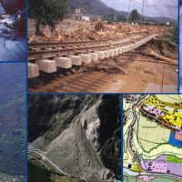
 FLIRE is a demonstration project aiming to the development of an integrated Decision Support System (DSS) for both flash floods and forest fires risk assessment and management. The DSS tool will be designed by using state of art tools, technologies and methods and taking into account prevention, adaptation and interaction issues. The final model will be online available to key stakeholders and relevant authorities (local and national) for the ...
 Sediment management in Alpine basins
 The understanding of the changing equilibrium between sediment supply from upstream and sediment transport capability of a river is important for the success of integrated water resource management. In Alpine river basins, intensive sediment transport processes and sediment continuity have a notable impact on several water management issues posing multiple use conflicts related to hydropower, ecology, flood control ...
 Spatially distributed modelling of landslide phenomena
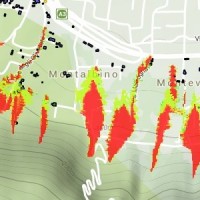
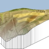 The application of distributed physically based models is possible on relatively small areas, typically hundreds or few thousands of km2. Distributed modelling of slope dynamics requires many sufficiently detailed information. Knowledge of geotechnical parameters and land use, digital terrain models, medium/high resolution cartography, temporal evolution of soil moisture conditions, are ...
 Assessment of water Balances and Optimisation based Target setting across EU River Basins
 ABOT is one of the Pilot projects on Development of Prevention Activities to Halt Desertification in Europe, partly funded by DG Environment of the European Commission. The objective of the pilot projects is to support the development of concrete pilot initiatives on innovative technologies, techniques or practices in order to contribute to the exchanges of good practice and innovation for halting the desertification in ...
 Changing Hydro-meteorological Risks as Analyzed by a New Generation of European Scientists
 The European Commission has identified the need for adaptations in risk management as a consequence to climate and environmental changes in several documents. The implementation of risk management measures such as disaster preparedness programmes, land-use planning, regulatory zoning and early warning systems are considered essential. Further, multi-risk assessment approaches are not used in planning practice: risk indicators are hardly used ...
 Ground Deformations Risk Scenarios: an advanced assessment service
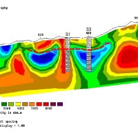
 DORIS - Ground Deformations Risk Scenarios: an advanced assessment service is an advanced downstream service for the detection, mapping, monitoring and forecasting of ground deformations, at different temporal and spatial scales and in various physiographic and climatic and environments. DORIS integrates traditional and innovative Earth Observation (EO) and ground based (non-EO) data and technologies to improve our understanding of the ...
 Glacial hazards in the western Alps
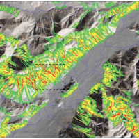
 The project is included in Operative Program of the European cross-border territorial cooperation "Alcotra 2007-2013". It brings together specialized scientific expertise Italian and French that deal to study the mountain and its dangerousness. It is divided into a part of studies conducted on the entire framework of the Western Alps and in actions on the pilot sites identified by the ...
 Investigation of postglacial fault zones using DInSAR
 Fennoscandia bears witness of the Pleistocene glaciation in the form of a series of large geological faults. Pärvie which is the longest runs for 150 km. No information is available on its state of activity and no surface deformations data have ever been collected. The length of the fault and its location, make the traditional monitoring techniques unfeasible and ...
 Landslide hazard in coastal areas: the natural laboratory of the Malta island
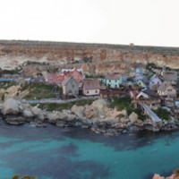 The research project can be included within the context of increasing hydrogeological instability also due to climate change and aims at investigating coastal instability in the island of Malta. This aspect has been until now slightly dealt with, despite significant risk issues, as evidenced from a series of accidents/damages recorded after landslide ...
 Long-term Permafrost Monitoring Network
 Permafrost is very sensitive to climate change and the risks associated with its degradation affect traffic routes, settlements and infrastructure. Data on the distribution of permafrost are inconsistent and there is no common strategy to tackle this problem. Local administrators should have the means to manage the risks associated with the degradation of the ...
 Mountain Risks: from prediction to management and governance
 The observed increase in disastrous events over the last decades, associated with a low perception of risk by the communities involved, along with the lack of efficient, socially accepted and environmentally sound remedial measures are amongst the motivation behind this research project. The adaptation of a combined multi-risk-oriented analysis, in which the investigations focus more on the interdependence of events rather than on single event, ...
 Hydrometeorological data resources and technologies for effective flash flood forecasting
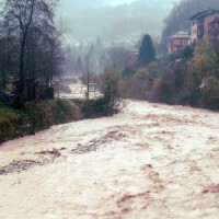 Flash-floods develop at space and time scales that conventional observation systems for rainfall and river discharge are not able to monitor. Consequently, the atmospheric and hydrological generating mechanisms of flash-floods are poorly understood, leading to highly uncertain forecasts of these ...
 Albanian International Center on Marine Sciences
 The project CISM faces problems related to marine Albanian waters in view of the Adriatic basin, which must meet various environmental problems in other portions of the Adriatic Sea, which are still influenced by the contribution of Albanian waters. CISM is not only a time of growth of the scientific culture of Albania, but also a landmark in the international scenario of the Adriatic ...
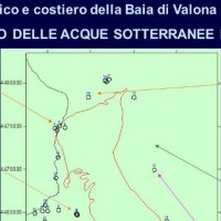
 Vulnerability maps for monitoring and management of groundwater resources in the Archimed area
 The project considered the strong demand of local institutions to select the best existing practices, in relation to different national and local characteristics, considering the regulatory ...
 Monitoring, Forecasting and Best Practices for FLOOD Mitigation & Prevention in the CADSES Region
 Hydrometeorological monitoring and flood forecasting are indispensable in preventing hydraulic hazard and ensuring civil protection. Implementing a sustainable plan to combat floods requires further activities, such as best practices for agricultural, forestry and land use management in flood risk areas. Methodologies must be developped within a transnational context, transending local ...
 Landslide Early Warning Integrated System
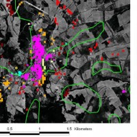 The focus on landslides results from the recognition that in many European countries slope instabilities affect urbanized areas and are a major threat to populations.
Through the integration of remotely sensed data with ground data we identify significant surface changes which are taking place on landslide susceptible slopes and this is used as input to the assessment of ...
The focus on landslides results from the recognition that in many European countries slope instabilities affect urbanized areas and are a major threat to populations.
Through the integration of remotely sensed data with ground data we identify significant surface changes which are taking place on landslide susceptible slopes and this is used as input to the assessment of ... Prevention, Information and Early Warning pre-operational services to support the management of risks
 PREVIEW is an integrated project by the European Commission 6th Framework Programme, led by the EURORISK Consortium, a multi-disciplinary European Team of committing Actors of the domain: Civil Protections and Environmental Bodies; Scientific communities and Service operators, at national and regional level, for Meteorology, Hydrology, Seismology, Volcanology and GIS services based on Space data; and Industry. The project was organized around a ...
 RISK-Advanced Weather forecasting system to Advice on Risk Events and management
The RISK-AWARE project contributed to at fostering our collective ability to forecast the consequences of severe meteorological conditions, including high intensity and prolonged rainfall periods. For the purpose, geological/geomorphological models that predict the location and timing of landslides, or the propensity of a territory to generate slope failures, are of primary ...
Responding to the risks from climate change
 ‘Response’ (or ‘Responding to the risks from climate change’) is a three-year Project supported by the LIFE financial instrument of the European Community, completed in December 2006. The Project provides a framework for understanding and preparing for the impacts of climate change around the European ...
 Karst ecosystems in Albania
 About 25% of Albania is interested by karst landscapes in both carbonates and evaporite rocks, with a variety of surface and subsurface landforms worth to be exploited. Despite their high value in terms of natural heritage, in the past years these areas suffered from degradation and pollution problems, that were further exacerbated by the difficult social and economical situation of the Balkans in the ...
 Debris fall assessment in mountain catchments for local end users
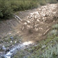
 Debris flows and rockfalls are a familiar hazard in European mountain areas and regularly cause loss of life, livelihood and property. Hazard assessment is therefore increasingly required in land use planning. However, there are no standard techniques and existing operational techniques are qualitative.
DAMOCLES developed quantitative technologies for assessing the distribution of rapid slope failures and their hazard, for determining the ...
Debris flows and rockfalls are a familiar hazard in European mountain areas and regularly cause loss of life, livelihood and property. Hazard assessment is therefore increasingly required in land use planning. However, there are no standard techniques and existing operational techniques are qualitative.
DAMOCLES developed quantitative technologies for assessing the distribution of rapid slope failures and their hazard, for determining the ...