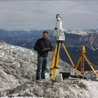
The Copernicus Sentinel-3 Surface Topography Mission (STM) provides extremely valuable surface elevation information over inland waters, sea ice and land ice, thanks to its SAR altimeter which retrieves high-resolution along-track elevation measurements, and to its orbit that covers high-latitude polar regions.
To ensure that these measurements can be used with confidence, and to maximize the return on investment of the Copernicus Sentinel-3 ...

The documented effects of climate change and environmental degradation are a threat to human societies on European and global scales. Climate change may have an impact on water availability, may increase the threat of flooding and flash-floods, and will challenge coastal regions due to rising sea levels. All this will have impacts on the economy and society. The role of citizens and their skills become important both in limiting human impacts ...
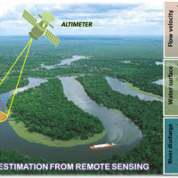
River discharge is defined as the amount of water flowing through a river over a specified period of time. Its estimate is crucial for all the operations of hydraulic structures design, the territorial planning and the flood risk assessment and management. River discharge at a specific river cross-section is not a direct measurement, but it is calculated by measuring other hydraulic quantities such as the flow velocity and the water depth, i.e. ...
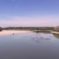
The Mar Piccolo basin is an internal sea basin located along the Ionian coast (Southern Italy), and it is surrounded primarily by fractured carbonate karstic environment.
In primarily karstic environments, infiltration is greater than runoff; in the karstic coastal Apulian aquifers, the groundwater discharge to the sea is more than two-fold greater than the surface discharge, notwithstanding the high discharges by wells. In such ...
The MUHA project is building upon the idea to address disaster management cycle consisting of preparedness-response-mitigation-rebuild components in the ADRION countries. It will connect the observed and modelled hazards and risks related to the integrated water cycle, by effectively join them with the existing and improved coping capacity developed by national, bilateral and EU Civil Protection ...
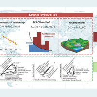
Water is at the centre of economic and social development; it is vital to maintain health, grow food, manage the environment, and create jobs. As well over half of the world’s potable water supply is extracted from rivers, either directly or from reservoirs, understanding the variability of the stored water on and below landmasses, i.e., total runoff, is of primary importance. In situ observations or land surface/hydrological models are ...
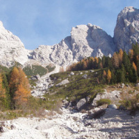
The dataset includes precipitation, temperature and discharge data recorded in the Missiaga catchment (Dolomites). The Missiaga catchment was monitored by CNR IRPI from 1983 to ...
With more than 5 million people affected, more than 1000 killed, and with estimated total damages exceeding 4.5 billion Euros just in Europe and during the last decade, floods are among the most disruptive natural events threatening our Society. Due to increase in extreme weather events and rapid socio-economic developments in vulnerable locations, the risks connected to floods in general are growing rapidly, and the awareness of these risks ...
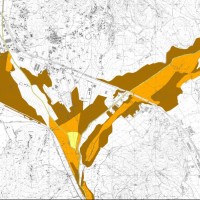
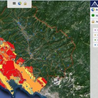
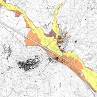
The activities of the project concern the delineation of hazard maps for return periods of 50, 100, 200 and 500 years for many reaches of interest identified in the secondary hydrographic network of Tiber ...
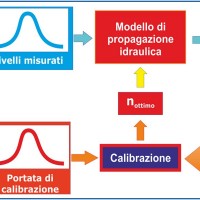
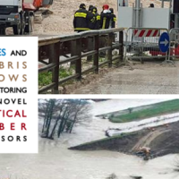
River discharge monitoring is fundamental for the study of the hydraulic regime of river flow and for the validation and calibration of rainfall-runoff models. The assessment of channel roughness coefficients associated with the measured discharges is fundamental for the calibration of flood routing models that can be used to address civil protection activities in real time. Unfortunately, the number of river flow monitoring stations in the ...
The main activities of the project, developed in the context of the program Nextdata funded by the Italian Ministry of Education, University and Research (MIUR), are:
collection, organization and analysis of the available hydro-meteorological and climate data for the characterization of the meteo-climate evolution in Apennine mountain areas;
extensive experimental campaigns for soil moisture monitoring in hillslope portions and ...
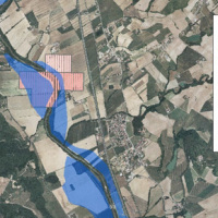
The Tiber River Basin Authority (ABT) and the Umbria Region (Service Water Resources and Hydraulic Risk), considering the verified underestimation of the flood-prone areas in the Paglia River basin provided by the Italian PAI (hydro-geological management plan) and the update of rating curves, decided to revise the hydrological study of the drainage basin in order to re-estimate the flood hazard maps for the Paglia River reach bounded upstream ...
The project activities concern:
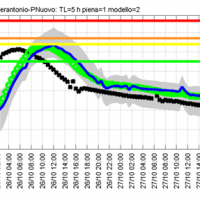
development and implementation of: 1) a semi-distributed continuous hydrological model (MISDc) for real-time soil moisture estimate and river discharge prediction in the Upper-Middle Tiber River basin; 2) a flood wave routing model (STAFOM-RCM) for stage hydrograph forecasting at some selected hydrometric stations in the Tiber River basin;
support for installation of soil moisture sensors in the ...
On 25-27 November 2005, the territory of central Italy was affected by heavy rainfall that hit the Tiber River basin and, mainly, the province of Perugia. The meteoric event had a significant phase with a duration of approximately 48 hours with widespread precipitation up to a maximum accumulated value higher than 100 mm. Significant increases in water levels occurred in most rivers of Upper-Middle Tiber
causing extended flooding in ...

Water and sediment connectivity has emerged in recent years as a significant conceptual framework for understanding the transfer of surface water and sediment through landscapes. Connectivity can be seen both as a driver of hydrological and geomorphic processes within a catchment and as an emergent catchment property that is the result of processes acting at different ...
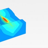
The project AIM-DAMS is aimed at developing a laboratory of integrated and advanced environmental monitoring for the control of the behavior of the earth-dams due to the different factors acting on the dams during their lifetime. Based on the integration of innovative and non-invasive sensors, as well as recent monitoring techniques and numerical modelling, the project is intended to fulfill the need of the dam management agencies of using ...
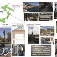
ABOT is one of the Pilot projects on Development of Prevention Activities to Halt Desertification in Europe, partly funded by DG Environment of the European Commission. The objective of the pilot projects is to support the development of concrete pilot initiatives on innovative technologies, techniques or practices in order to contribute to the exchanges of good practice and innovation for halting the desertification in ...
VIGOR contributed to increasing knowledge in exploitation of geothermal resources. It was aimed at providing information useful to start exploration and utilization of geothermal energy, through reconnaissance, analyses and studies, valorise geothermal resources in Calabria, Campania, Puglia and Sicily.
In particular, geological and geothermal characterization were carried both at regional scale (i.e. maps of geothermal potential) and at the ...
Permafrost is very sensitive to climate change and the risks associated with its degradation affect traffic routes, settlements and infrastructure. Data on the distribution of permafrost are inconsistent and there is no common strategy to tackle this problem. Local administrators should have the means to manage the risks associated with the degradation of the ...
The project considered the strong demand of local institutions to select the best existing practices, in relation to different national and local characteristics, considering the regulatory ...
