
Theme: Deformation
Kinematics of slow-moving active landslides
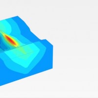
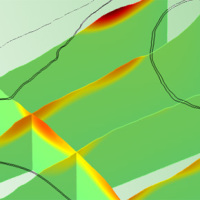 We experiment the application of 3D numerical modelling techniques for the analysis of the kinematics of slow-moving active landslides. The activity assesses the hazards posed by slow-moving landslides, determines the factors controlling the slope processes, investigates the potential evolution of the active slopes, and helps selecting appropriate slope mitigation strategies.
We exploit modern numerical modelling techniques based on finite ...
We experiment the application of 3D numerical modelling techniques for the analysis of the kinematics of slow-moving active landslides. The activity assesses the hazards posed by slow-moving landslides, determines the factors controlling the slope processes, investigates the potential evolution of the active slopes, and helps selecting appropriate slope mitigation strategies.
We exploit modern numerical modelling techniques based on finite ... Study and monitoring activities on Arzeno landslide – Municipality of Ne (GE)
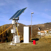 The Municipality of Ne (GE) is involved by an important landslide in the Arzeno and Prato di Reppia areas. The phenomenon is monitored using standard techniques for some years. The goals of this study is increasing the knowledge of the phenomenon using automatic monitoring ...
 Radar remote sensing techniques for the detection and measurements of ground surface deformations
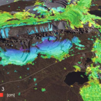 Space-borne radar interferometry or DInSAR (Differential Interferometric Synthetic Aperture Radar) is one of the latest techniques used for the detection and measurement of ground surface deformations caused by natural and / or man-made events. The DInSAR technique has been successfully used in the measurement of seismic deformations and of the effects of subsidence, unstable slopes and inflation of magma in volcanoes. The growth of space ...
 Threedimensional Displacement Analysis
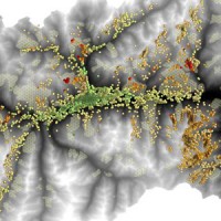
 The 3DA software is a new procedure that allows retrieving in near-real-time 3D surface deformation models starting from data acquired via robotized total stations or others system that acquire the surface displacements. The measurements are first pre-processed and then implemented on 3D maps that include vector arrows representative of the intensities and of the real directions of motion in a given system of coordinates. The 3D surface ...
 RelationsHips between meteo-climAtic paraMeters and ground surface deforMation time sEries in mountain enviRonments
 There is a systematic lack of information on the effects of the climate and environmental changes on the frequency and the intensity of landslides and their triggering phenomena (Huggel et al., 2012). The problem is particular severe in mountain area, where natural and human-driven climatic and environmental changes may alter significantly the frequency and the intensity of the slope processes, with largely unknown short and long-term effects ...
 Advanced and Integrated Monitoring of Earth DAMS
 The project AIM-DAMS is aimed at developing a laboratory of integrated and advanced environmental monitoring for the control of the behavior of the earth-dams due to the different factors acting on the dams during their lifetime. Based on the integration of innovative and non-invasive sensors, as well as recent monitoring techniques and numerical modelling, the project is intended to fulfill the need of the dam management agencies of using ...