
Taiwan, Republic of China
The coloured circles represent the total number of activities (project, products and services, outreach, collaborations) that we have in the corresponding geographical zone
Map data: © OpenStreetMap contributors
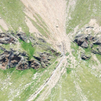
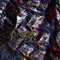
Earthquake-induced landslides
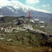 Landslides and earthquakes are important geological hazards in Italy, where mountains and hills dominate a landscape characterized by the presence of weak geological materials. The geological and morphological settings result in high susceptibility to landslides under seismic conditions. Italy is also one of the most active tectonic regions in Europe; and seismic shaking is known to have caused landslides in Italy.
Numerous historical ...
Landslides and earthquakes are important geological hazards in Italy, where mountains and hills dominate a landscape characterized by the presence of weak geological materials. The geological and morphological settings result in high susceptibility to landslides under seismic conditions. Italy is also one of the most active tectonic regions in Europe; and seismic shaking is known to have caused landslides in Italy.
Numerous historical ... Mappatura, Modellazione e Previsione Multiscala dei RIschi GEo-idroLogici
 Italy has a tradition of scientific research and technological development on hazardous natural phenomena in general, and specifically on geo-hydrological hazards. Within the CNR, the “Progetti Finalizzati” Soil Conservation and Geodynamics (in the ’70s and ’80s), and GNDCI – the National Group for the Defence from Hydrogeological Disasters (in the ’80s and ’90s), have contributed to the advancement of knowledge ...
 Land cover change detection and monitoring methodologies based on the combined use of S1 and S2 for natural resources and hazard management
 ESA Sentinels missions will provide enhanced capabilities in the revisit frequency, and the coverage. Their complete exploitation is in the combination of the two to advantage of a further increased revisiting time and in the use of different wavelenght domains. This reflects in the capabilities to detect features of changes induced by different factors including natural hazards and crop ...
 Spectral signatures library for semi-automatic event landslide recognition and mapping
 Earthquakes and strong rainfall precipitations, cause worldwide landslide. Inventories of the ground effects of an event must be prepared in a few days or less for the residual risk management. Satellite images and image analysis techniques have started to back up traditional mapping methods. Purpose of this project is to increase the automatization of image ...
 Landslide Modelling and tools for vulnerability assessment Preparedness and REcovery management
 Il progetto FP7 LAMPRE - Landslide Modelling and tools for vulnerability assessment Preparedness and Recovery management svolge attività di ricerca innovative e di sviluppo tecnologico per migliorare le capacità del sistema Copernicus di far fronte a eventi di frana e alle loro conseguenze, in Europa e in altre parti del mondo. LAMPRE migliora il rischio di frana sforzi di mitigazione / preparazione e le attività di recupero e di ...
 SAR change detection methodologies for event landslide mapping
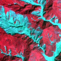
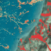
 The project explores and implements multi-scale and multi-sensor SAR change detection methodologies for event landslide mapping. Automated analysis for change detection is a challenging task due
to the inherent noisiness of SAR imagery and also to the high sensitivity to texture variability due to different acquisition angles. Moreover, pre-processing (de-speckling) may lead to the degradation
of the geometrical details and affect the ...
The project explores and implements multi-scale and multi-sensor SAR change detection methodologies for event landslide mapping. Automated analysis for change detection is a challenging task due
to the inherent noisiness of SAR imagery and also to the high sensitivity to texture variability due to different acquisition angles. Moreover, pre-processing (de-speckling) may lead to the degradation
of the geometrical details and affect the ... Rainfall, seismicity, landslides and sediment discharge in mountain belts
 Taiwan, an active orogenic belt with subtropical climate is characterized by a high uplift rate and several major typhoons each year. Italy is on one of the most seismically active regions in Europe because of the thrust of African plate on Eurasian continental one. Both experience numerous landslides along with earthquakes and intense rainfalls, causing heavy damages and casualties. The purpose of this project was to share scientific knowledge ...