
Veneto
The coloured circles represent the total number of activities (project, products and services, outreach, collaborations) that we have in the corresponding geographical zone
Map data: © OpenStreetMap contributors
What’s underneath?
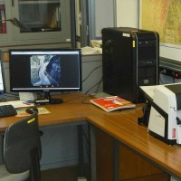
 When soil behaviour is studied, whether landslide soils are concern, levee materials or foundations, the problem regarding how much and how reliable information about the soil properties we have available has to be addressed.
Understanding “what’s beneath” the visible surface is fundamental, yet complicated. Drillings are performed to analyse the stratigraphy of soils (the order and the thickness of the different soil levels) and ...
When soil behaviour is studied, whether landslide soils are concern, levee materials or foundations, the problem regarding how much and how reliable information about the soil properties we have available has to be addressed.
Understanding “what’s beneath” the visible surface is fundamental, yet complicated. Drillings are performed to analyse the stratigraphy of soils (the order and the thickness of the different soil levels) and ... Assessing sediment connectivity and availability in several mountain catchments in the Veneto Region
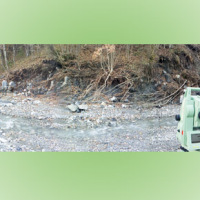
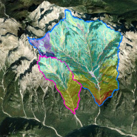 Mass wasting is a threat to residential areas and infrastructure, causing widespread destabilization in alpine stream channels, also in relation to ongoing climatic changes. Although hillslope sediment supply represents a critical factor for stream channel stability during heavy rainstorms, there is a general lack of procedures for quantifying sediment availability and composition. Moreover, we lack validated empirical models for estimating ...
 Fiber optic sensors engineering for the monitoring of structural reinforcements on unstable slopes
 Geo-Hydrological risks are one of the main sources of economic losses for our country causing a huge number of victims and damages. From 1966 to 2015, landslides and floods caused 1948 casualties, 3524 injured and more than 412,000 displaced people. The Venetian mountain has always been subject to major landslides and, almost every year, new emergencies occur with the intensification of the autumn and spring rains, which are increasing due to ...
 Rheology of geological processes
 Critical and depositional friction angles are characteristic for the deposition of a granular mass; the wrong angle adoption determines the ineffectiveness of a containment basin. The term is used with different meanings and measured by various procedures. The numerical simulation is a useful tool for the hazard assessment, but the definition of friction needed parameters requires insights on their ...
 Large landslides: Monitoring, Modelling and Mitigation
 The study of the dynamics of large landslide is a heuristic process based on the integration of multiple investigation techniques: geological and geomorphological analysis, monitoring systems (traditional and innovative) and numerical models. Risk mitigation may require major interventions that call for detailed studies on the specific ...
 Geomorphometry and sediment dynamics in mountain catchments
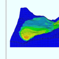
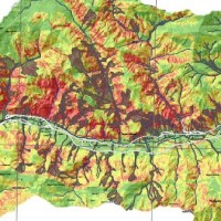
 The aim of the geomorphometric analysis is to derive indices capable of characterizing the spatial variability of specific hydro-geomorphological processes (e.g., sediment connectivity, erosion and deposit). The growing availability of high-resolution topographic data has increased the interest in geomorphometry and its applications. Debris-flow monitoring in instrumented areas and flash-flood documentation are invaluable ways to gather field ...
 Attività di studio sui conoidi alluvionali in Veneto
 On May 13, 2016, CNR IRPI presented in Belluno the results of the analysis of alluvial fans in the Veneto Region which envisage the development of a methodology for the analysis of floods and debris flows and the application to test areas in the Province of Belluno, Vicenza and Treviso. The results of the analysis have been mentioned, on 14/05/2016, in some articles of local ...
 Analysis of alluvial fans in the Veneto Region
 On May 13, 2016, CNR IRPI presented in Belluno the results of the analysis of alluvial fans in the Veneto Region which envisage the development of a methodology for the analysis of floods and debris flows and the application to test areas in the Province of Belluno, Vicenza and Treviso. The results of the analysis have been mentioned in a report of Antenna 3 News, on 13/05/2016.
Link to Antenna 3 News ...
On May 13, 2016, CNR IRPI presented in Belluno the results of the analysis of alluvial fans in the Veneto Region which envisage the development of a methodology for the analysis of floods and debris flows and the application to test areas in the Province of Belluno, Vicenza and Treviso. The results of the analysis have been mentioned in a report of Antenna 3 News, on 13/05/2016.
Link to Antenna 3 News ... Methodologies for the analysis of alluvial fans
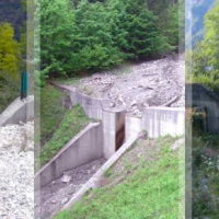 Some areas mapped in the Piani di Assetto Idrogeologico (Watershed Management Plan) of Piave, Brenta-Bacchiglione and Livenza Rivers require specific studies aimed at assigning a degree of hazard. Among the warning areas, there are numerous alluvial fans. The Soil Conservation Division of Veneto Region, in charge of the inquiry, identified the need to find an objective method for assessing the hazard of such ...
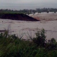
 Web-based relational database on the main levee breaches of the Po River (Northern Italy)
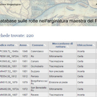 This is the web-based relational database on the main levee breaches of the Po River (Italy), which have occurred since the year 1800.
The database contains more than 200 fact sheets that show the information for each levee failure. For each fact sheet are attached documents and maps. The access is free of charge.
This database may provide a valid support in the design of defense interventions directed at the prevention and mitigation of ...
This is the web-based relational database on the main levee breaches of the Po River (Italy), which have occurred since the year 1800.
The database contains more than 200 fact sheets that show the information for each levee failure. For each fact sheet are attached documents and maps. The access is free of charge.
This database may provide a valid support in the design of defense interventions directed at the prevention and mitigation of ... Dolomiti, l’allarme del CNR: “Svuotate subito i canaloni”
 Articolo del "Corriere delle Alpi" del 09 agosto 2015.
Fausto Guzzetti (direttore del CNR IRPI) e Lorenzo Marchi (CNR IRPI - Sezione di Padova) forniscono la loro consulenza sul problema delle frane verificatesi tra Cortina e San Vito di ...
Articolo del "Corriere delle Alpi" del 09 agosto 2015.
Fausto Guzzetti (direttore del CNR IRPI) e Lorenzo Marchi (CNR IRPI - Sezione di Padova) forniscono la loro consulenza sul problema delle frane verificatesi tra Cortina e San Vito di ... RAI NEWS 24: Intervista a Fausto Guzzetti del CNR IRPI
 Fausto Guzzetti, Direttore del CNR IRPI, viene intervistato il 5 agosto 2015 da RAI NEWS 24 per capire meglio la tragedia del ...
 Rischio frana due accordi per nuovi studi
Breve articolo dell'1 luglio 2015, scritto sul Messaggero Veneto, in cui si parla dell'IRPI CNR impegnato in due accordi per la prevenzione del rischio frana nella Valle del ... Data on maximum annual rainfall in north-eastern Italy
 The database includes annual maximum rainfall corresponding to durations of 1, 3, 6, 12, 24 hours and 1, 2, 3, 4, 5 days for approximately 800 raingauges in north-eastern Italy (Trentino, Alto Adige, Veneto and Friuli Venezia Giulia). The database contains data until 1997 for the Autonomous Province of Bozen-Bolzano, 1990 for the Autonomous Province of Trento, and 1996 for Veneto and Friuli Venezia ...
 Aerofototeca
 The CNR IRPI archive preserves 170.000 aerial photographs useful for stereoscopic applications. Most part of those photographs were taken during a number of surveys carried out between 1954 and 2005 in tha Padan Plain, Triveneto and Liguria (Northern Italy) but some examples date from the 1920s, 1930s and 1940s.
In this documentation the effects of many floods and landslides events can be observed. In particular, we would mention the aerial ...
The CNR IRPI archive preserves 170.000 aerial photographs useful for stereoscopic applications. Most part of those photographs were taken during a number of surveys carried out between 1954 and 2005 in tha Padan Plain, Triveneto and Liguria (Northern Italy) but some examples date from the 1920s, 1930s and 1940s.
In this documentation the effects of many floods and landslides events can be observed. In particular, we would mention the aerial ... 1963-2013: anniversario del disastro del Vajont
Intervento della dott.ssa Paola Salvati nello spazio dedicato al 50° anniversario del disastro del Vajont, andato in onda durante la puntata del 9 ottobre 2013 di Geo&Geo (Rai3).
[video width="512" height="288" ... Increasing Resilience through Earth Observation
 To significantly contribute to the operational capacities in the context of Global Monitoring for Environment and Security (GMES)/ Copernicus by developing customised mapping and geo-information products addressing risk, vulnerability and assets ready for deployment in the prevention and preparedness phases – complementary to the GMES/Copernicus Emergency Management Service. Solutions to be provided are based for the most part on Earth ...
 RIVERbank Surveillance bAsed on Fiber optic sEnsors
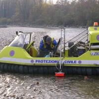
 In the last decades Europe and Italy suffered many damaging floods, causing thousands of deaths, the displacement of millions of people and billions of euros in insured economic losses. Veneto Region has been also strongly stricken in 2010. The European Commission has identified the need for adaptation of risk management in several documents in order to reduce the likelihood and/or the impact of floods [1]. Starting from these remarks, the main ...
 La Ricerca ITaliana per il MARE
 UK The Italian maritime cluster represents for Italy an important economic sector contributing to 2.6% of national GDP, 11% of production in the industry of transport, and using almost 1% of the units of work identified in the country, share as high as 2% including the impact of upstream and downstream, for a total of around 480,000 employees (Cluster and maritime development in Italy and in the regions CENSIS - September 2011). In the European ...
 Innovative System for Monitoring and assessment of hIgh risk LANDslides
 One of the main challenges in the field of engineering geology is the comprehension of the triggering mechanisms of landslides and the forecast of possible evolutionary scenarios in order to assess the correct mitigation measures. Landslides can be initiated by a variety of triggers: from earthquakes to meteorological events, including intense or prolonged rainfall, rapid snow melting, and variations of the surface temperature conditions. ...
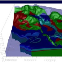
 Study of the riverbeds morphological evolution through the digital terrain models multi-temporal analysis
 The study of the evolution of the watercourses is traditionally based on the use of historical maps and aerial photographs for the comprehension of the planimetric changes and on the use of topographical sections in order to have also the measure of the altimetric change occurred in the considered time interval.
Through this approach it is possible, for the Po basin, to have the first indications of the main watercourses evolution starting ...
The study of the evolution of the watercourses is traditionally based on the use of historical maps and aerial photographs for the comprehension of the planimetric changes and on the use of topographical sections in order to have also the measure of the altimetric change occurred in the considered time interval.
Through this approach it is possible, for the Po basin, to have the first indications of the main watercourses evolution starting ...