
Toscana
The coloured circles represent the total number of activities (project, products and services, outreach, collaborations) that we have in the corresponding geographical zone
Map data: © OpenStreetMap contributors
Progetto ADAPT
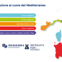 The ADAPT project, co-funded by the Interreg Italy-France Maritime Program 2014-2020, aims to adapt the Italian and French cities of the Upper Tyrrhenian to the consequences of climate change, with particular reference to the urban flash floods caused by intense meteorological ...
 Geomorphometry and sediment dynamics in mountain catchments
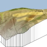
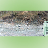 The aim of the geomorphometric analysis is to derive indices capable of characterizing the spatial variability of specific hydro-geomorphological processes (e.g., sediment connectivity, erosion and deposit). The growing availability of high-resolution topographic data has increased the interest in geomorphometry and its applications. Debris-flow monitoring in instrumented areas and flash-flood documentation are invaluable ways to gather field ...
 Sentinel for Geohazards regional monitoring and forecasting
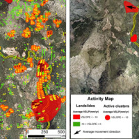 SAFETY aims at providing Civil Protection Authorities with the capability of periodically evaluating and assessing the potential impact of geohazards (volcanic activity, landslides and subsidence) on urban areas. The project improves the effort to detect and map geohazards, assess their activity and evaluate their impact on built-up areas and infrastructures ...
 Lazio, Abruzzo e Toscana contano i danni
 Articolo contenente dati del CNR-IRPI pubblicato nel sito del Sole 24 ore il 17 ottobre 2015, riguardante i danni provocati dal maltempo dei giorni scorsi.
Vai ...
Articolo contenente dati del CNR-IRPI pubblicato nel sito del Sole 24 ore il 17 ottobre 2015, riguardante i danni provocati dal maltempo dei giorni scorsi.
Vai ... Multi Scale and Multi Hazard MApping Space Solutions
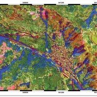 The exploitation of innovative methods of SAR and optical data processing, combined to the use of ancillary data, is able to provide useful products for the landslide and seismic hazard ...
 Spatially distributed modelling of landslide phenomena
 The application of distributed physically based models is possible on relatively small areas, typically hundreds or few thousands of km2. Distributed modelling of slope dynamics requires many sufficiently detailed information. Knowledge of geotechnical parameters and land use, digital terrain models, medium/high resolution cartography, temporal evolution of soil moisture conditions, are ...
 Variante, i residenti: «Il viadotto si è spostato di 3 centimetri»
Articolo di Noemi Bicchiarelli pubblicato su corrieredibologna.it il 22 maggio ... Variante Valico, tutte le parti in commissione
Articolo pubblicato su bologna2000.com il 22 maggio ... Ripoli, i cantieri ripartono «Ma controlli più mirati»
Articolo di Amelia Esposito pubblicato su corrieredibologna.it il 3 maggio ... Frana la Variante di Valico, pronto un piano di evacuazione dei paesi
Articolo di David Marceddu pubblicato il 3 maggio 2012 su ilfattoquotidiano.it edizione ... Variante di valico, i costruttori: “Inutilizzabile l’autostrada del Sole”
Articolo di Luigi Spezia pubblicato il 3 maggio 2012 su laRepubblica.it edizione di ... Topographic monitoring of the Costa Concordia vessel wreck
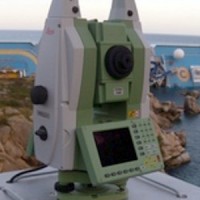 Following the run aground off near the "Isola del Giglio" (Tuscany, Italy, January 13, 2012) of the cruise vessel "Costa Concordia", a monitoring system for handling the security of the SAR (Search and Rescue) operations and for the control of the ships' movements/deformations during the subsequent defueling and recovery phases has been progressively installed and ...