
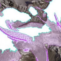
Piemonte
The coloured circles represent the total number of activities (project, products and services, outreach, collaborations) that we have in the corresponding geographical zone
Map data: © OpenStreetMap contributors
The improvement of the expressive and learning abilities of the adult
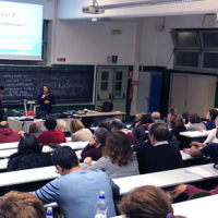 The researches and the experimentations carried out, in the learning field, by the IRPI Institute during the last years, started out initially in the field of geoethics, have allowed to set up principles and didactic tools that offer today practical and usable tools to significantly improve, in a relatively short period of time, the expressive, learning and assimilation capacities of students and adults.
The researches have been originally ...
The researches and the experimentations carried out, in the learning field, by the IRPI Institute during the last years, started out initially in the field of geoethics, have allowed to set up principles and didactic tools that offer today practical and usable tools to significantly improve, in a relatively short period of time, the expressive, learning and assimilation capacities of students and adults.
The researches have been originally ... Automated Inclinometer System (AIS) for deep-seated ground deformation measurements
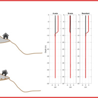 Our AIS (Automated Inclinometer System) allows for fully automatic inclinometer measurements in standard boreholes. The deep measurements have multiple applications, including (i) evaluating the rate of deep-seated ground deformation in landslide areas, (ii) evaluating the volume of deep-seated landslides, and (ii) assessing landslide hazards.
The AIS is composed of an electronic control manager, an inclinometer probe (with traditional ...
Our AIS (Automated Inclinometer System) allows for fully automatic inclinometer measurements in standard boreholes. The deep measurements have multiple applications, including (i) evaluating the rate of deep-seated ground deformation in landslide areas, (ii) evaluating the volume of deep-seated landslides, and (ii) assessing landslide hazards.
The AIS is composed of an electronic control manager, an inclinometer probe (with traditional ... Debris-flow monitoring in the Alps
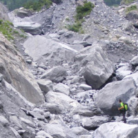
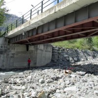
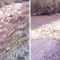 Not all that flows in creeks is water. Debris flows i.e., surges in which solid particles move together with little water, may occur in steep mountain streams, mainly as a consequence of intense rainfall. Debris flows have a high kinetic energy, and may cause major damage if they encroach buildings, roads and bridges. They are also a primary cause of landslide casualties. The video below shows an example of debris flows.
The low ...
Not all that flows in creeks is water. Debris flows i.e., surges in which solid particles move together with little water, may occur in steep mountain streams, mainly as a consequence of intense rainfall. Debris flows have a high kinetic energy, and may cause major damage if they encroach buildings, roads and bridges. They are also a primary cause of landslide casualties. The video below shows an example of debris flows.
The low ... The strong retreat of the Italian glaciers
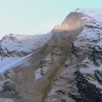
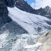
 Between the late 19th and early 21st century, in the Alps the average air temperature has increased by about 2 °C, more than twice the increase in temperature in the northern hemisphere, of 0.8 °C. In the same period, precipitation showed a tendency towards an increase in the northern part of the Alps, and a tendency towards a decrease in the southern sector of the Alps.
Since the end of the Little Ice Age (about 1850), glaciers in the ...
Between the late 19th and early 21st century, in the Alps the average air temperature has increased by about 2 °C, more than twice the increase in temperature in the northern hemisphere, of 0.8 °C. In the same period, precipitation showed a tendency towards an increase in the northern part of the Alps, and a tendency towards a decrease in the southern sector of the Alps.
Since the end of the Little Ice Age (about 1850), glaciers in the ... ALMOND-F, an ALarm and MONitoring system for Debris-Flows
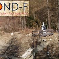 ALMOND-F is an innovative unit for the microseismic detection of debris flows using a network of geophones.
The microseismic detection of debris flows is more complex than other types of monitoring. Use of the geophones requires: (1) the selection of the level of amplification of the signal, which depends on the distance from the stream; (2) the selection of the sampling frequency of the seismic signal, which must be sufficiently high; (3) ...
ALMOND-F is an innovative unit for the microseismic detection of debris flows using a network of geophones.
The microseismic detection of debris flows is more complex than other types of monitoring. Use of the geophones requires: (1) the selection of the level of amplification of the signal, which depends on the distance from the stream; (2) the selection of the sampling frequency of the seismic signal, which must be sufficiently high; (3) ... Migliorare l’attenzione del pubblico per una più efficace comunicazione del rischio
 La sperimentazione ad ampio raggio condotta negli ultimi anni per testare sul campo la funzionalità e l’efficacia della procedura semplificata per la rielaborazione dei ricordi traumatici (RINOEL) ha consentito di evidenziare con sempre maggior chiarezza gli effetti esercitati da tali ricordi sull’attenzione di una persona. La capacità di concentrazione di un individuo, e dunque la sua abilità di focalizzare l’attenzione, risente ...
 Role of climate change in the morphogenesis of glacial-periglacial environments and analysis of associated risks
 Climate change in the Greater Alpine Region is seriously affecting glacial and periglacial areas, especially for the presence of snow, glaciers and permafrost (cryosphere), with relevant consequences on slope stability. Cryosphere degradation, changes of the precipitation and temperature patterns and of the hydrological regimes, are some of the main terrestrial indicators of climatic change. Moreover, the increasing number of tourists and human ...
 Landslide monitoring Innovative methods and instruments
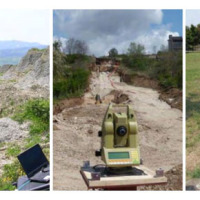 The development of new systems for monitoring of landslides is often the synthesis of geomatics and applied geology. In particular, the development of innovative low-cost systems must have a strong geomatics and technological component supported by the definition of required elements done by end users (engineering geologists). The development of low-cost monitoring systems can represent a strategic choice, above all, to guarantee an increasing ...
 RiST2, the research go on
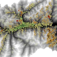
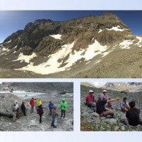 The researches at high-elevation sites continues, thanks to the RiST2 project (co-financed by Fondazione CRT of Torino). The study area is the Bessanese glacial basin. The Alpine environment and in particular the cryosphere, is responding quickly and with great intensity to climate change. The air temperature increase observed in the Alps urge the scientific communities involved in natural instability studies to consider not only air ...
 Cooperative Internet-of-Data Rural/Alpine Community Environment
 Environmental sensor monitoring is continuously developing, both in terms of quantity (i.e. measurement sites), and quality (i.e. technological innovation). Environmental monitoring is carried out by either public or private entities for their own specific purposes, such as scientific research, civil protection, support to industrial and agricultural activities, services for citizens, security, education and information.
The left Cenischia ...
Environmental sensor monitoring is continuously developing, both in terms of quantity (i.e. measurement sites), and quality (i.e. technological innovation). Environmental monitoring is carried out by either public or private entities for their own specific purposes, such as scientific research, civil protection, support to industrial and agricultural activities, services for citizens, security, education and information.
The left Cenischia ... Monitoring of the Gollone landslide, Acceglio (CN)
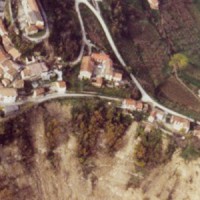
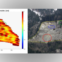 The landslide monitoring represents a strategic activity, especially for those phenomena for which it is not possible (for technical or financial reasons) to realize stabilization interventions of the landslide. Nevertheless, the data acquisition is only the first part of the project, to which it is necessary to couple an on line management of the processed data and to realize monitoring ...
 Preserving the quality of the scientific information
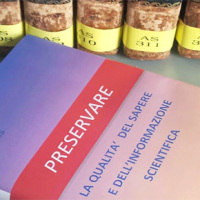 Producing knowledge implies the responsibility to divulge it with quality, making it available for everyone. With the advent of the Internet the possibilities to retransmit knowledge have grown, but the danger is also grown of a deterioration of its quality, as the Nobel prize Gell-mann already denounced in the nineties. The project intends to propose solutions to this kind of problem, contributing to improve the expressive capacity of thesis ...
 Geomorphometry and sediment dynamics in mountain catchments
 The aim of the geomorphometric analysis is to derive indices capable of characterizing the spatial variability of specific hydro-geomorphological processes (e.g., sediment connectivity, erosion and deposit). The growing availability of high-resolution topographic data has increased the interest in geomorphometry and its applications. Debris-flow monitoring in instrumented areas and flash-flood documentation are invaluable ways to gather field ...
 Il lago che non c’è più. Addio all'”Effimero”
 Articolo del quotidiano La Stampa del 02 agosto 2016.
Vai all'articolo ...
Articolo del quotidiano La Stampa del 02 agosto 2016.
Vai all'articolo ... RiST project: Scientific and Technological research in the Bessanese glacial basin (Balme, NW Italian Alps)
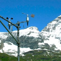
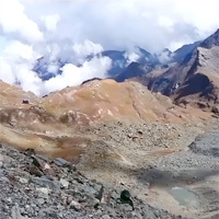
 The Alpine environment, and in particular the high-altitude one, is responding quickly and with great intensity to climate change, through evidences of geomorphological, hydrological and ecological type. Mountain glacier shrinkage and related outcropping of rock walls and debris, changes of the precipitation and temperature patterns, are some of the main terrestrial indicators of climatic ...
 Natural instability processes at high-elevation sites
 Natural instability processes at high-elevation sites and relationships with climate variability: research activities by IRPI GeoClimAlp
Short description of the GeoClimAlp activities, mainly oriented to the study of natural instability processes at high-elevation sites, also analysing their relationships with climate variability: the example of the Bessanese glacial basin during the summer 2015. Contact person: Marta Chiarle ...
Natural instability processes at high-elevation sites and relationships with climate variability: research activities by IRPI GeoClimAlp
Short description of the GeoClimAlp activities, mainly oriented to the study of natural instability processes at high-elevation sites, also analysing their relationships with climate variability: the example of the Bessanese glacial basin during the summer 2015. Contact person: Marta Chiarle ... Web-based relational database on the main levee breaches of the Po River (Northern Italy)
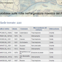 This is the web-based relational database on the main levee breaches of the Po River (Italy), which have occurred since the year 1800.
The database contains more than 200 fact sheets that show the information for each levee failure. For each fact sheet are attached documents and maps. The access is free of charge.
This database may provide a valid support in the design of defense interventions directed at the prevention and mitigation of ...
This is the web-based relational database on the main levee breaches of the Po River (Italy), which have occurred since the year 1800.
The database contains more than 200 fact sheets that show the information for each levee failure. For each fact sheet are attached documents and maps. The access is free of charge.
This database may provide a valid support in the design of defense interventions directed at the prevention and mitigation of ... Se ne va il ghiaccio del Monte Rosa «Così le Alpi si fanno più piccole»
 Articolo pubblicato sul 'Quotidiano Nazionale', del 3 ottobre 2015, che descrive la situazione in cui versa il ghiacciaio del Monte Rosa interpellando anche, tra i vari esperti, il ricercatore associato dell'IRPI CNR di Torino, Giovanni Mortara.
[pdf-light-viewer ...
Articolo pubblicato sul 'Quotidiano Nazionale', del 3 ottobre 2015, che descrive la situazione in cui versa il ghiacciaio del Monte Rosa interpellando anche, tra i vari esperti, il ricercatore associato dell'IRPI CNR di Torino, Giovanni Mortara.
[pdf-light-viewer ... Aerofototeca
 The CNR IRPI archive preserves 170.000 aerial photographs useful for stereoscopic applications. Most part of those photographs were taken during a number of surveys carried out between 1954 and 2005 in tha Padan Plain, Triveneto and Liguria (Northern Italy) but some examples date from the 1920s, 1930s and 1940s.
In this documentation the effects of many floods and landslides events can be observed. In particular, we would mention the aerial ...
The CNR IRPI archive preserves 170.000 aerial photographs useful for stereoscopic applications. Most part of those photographs were taken during a number of surveys carried out between 1954 and 2005 in tha Padan Plain, Triveneto and Liguria (Northern Italy) but some examples date from the 1920s, 1930s and 1940s.
In this documentation the effects of many floods and landslides events can be observed. In particular, we would mention the aerial ... Advanced Environment Monitoring System (SMAT) – F2
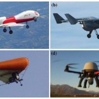 The environment monitoring has several purposes, including the prevention of geo-hydrogeological risks, forest fires, or prevention and suppression of illegal activities. The SMAT-F2 main objective is to define, design and develop an advanced monitoring system of the territory based on innovative unmanned air systems, coordinated by a supervision and coordination station (SSC). The first phase of the project, called SMAT-F1, finished at ...
 Tre progetti europei per la Val Maira
Articolo pubblicato sul quotidiano online TargatoCN, il 23 Ottobre 2014, nel quale si parla delle due giornate di convegno -17-18 ottobre 2014, San Damiano (CN)- dedicate alla presentazione di tre progetti europei che condividono la Val Maira come area di studio che hanno visto la partecipazione attiva del CNR IRPI di ... RelationsHips between meteo-climAtic paraMeters and ground surface deforMation time sEries in mountain enviRonments
 There is a systematic lack of information on the effects of the climate and environmental changes on the frequency and the intensity of landslides and their triggering phenomena (Huggel et al., 2012). The problem is particular severe in mountain area, where natural and human-driven climatic and environmental changes may alter significantly the frequency and the intensity of the slope processes, with largely unknown short and long-term effects ...
 Ventennale dell’Alluvione in Piemonte del 1994
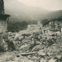
 Nel 2014 ricorrono vent’anni dalla tragica alluvione che nel novembre 1994 colpì gran parte del territorio piemontese, con perdita di vite umane, di beni mobili ed immobili. L’alluvione 1994 costituì altresì un momento storico nel campo della pianificazione territoriale, prevenzione e gestione della pericolosità e rischio geologico-idraulico, che si tradusse in dettami normativi, per l’epoca avanzati e lungimiranti. Da quell’evento ...
 Alarm and monitoring systems for debris and mud flows
 Monitoring of debris flows in instrumented areas is carried out since many years in different Countries worldwide. It is still missing, however, an adequate standardization of methodologies, instrumentations and procedures. The instrumented areas are also employed for testing warning systems. Even though these latter have been more and more employed, a systematic experimentation of these systems has not yet been carried ...
 Glacial hazards in the western Alps
 The project is included in Operative Program of the European cross-border territorial cooperation "Alcotra 2007-2013". It brings together specialized scientific expertise Italian and French that deal to study the mountain and its dangerousness. It is divided into a part of studies conducted on the entire framework of the Western Alps and in actions on the pilot sites identified by the ...
 Progetto Presídi
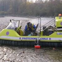
 Il progetto presidi soddisfa un’esigenza normativa (D.P.C.M. 27/02/2004) e conoscitiva della Protezione Civile Regionale del Piemonte; diventa uno strumento funzionale all’aggiornamento dei punti di criticità idrogeologica del territorio, individuati e verificati dopo una complessa indagine retrospettiva e lunga concertazione di diversi Enti territoriali competenti, e al loro monitoraggio durante le fasi parossistiche di eventi di piena o ...
 Study of the riverbeds morphological evolution through the digital terrain models multi-temporal analysis
 The study of the evolution of the watercourses is traditionally based on the use of historical maps and aerial photographs for the comprehension of the planimetric changes and on the use of topographical sections in order to have also the measure of the altimetric change occurred in the considered time interval.
Through this approach it is possible, for the Po basin, to have the first indications of the main watercourses evolution starting ...
The study of the evolution of the watercourses is traditionally based on the use of historical maps and aerial photographs for the comprehension of the planimetric changes and on the use of topographical sections in order to have also the measure of the altimetric change occurred in the considered time interval.
Through this approach it is possible, for the Po basin, to have the first indications of the main watercourses evolution starting ...