
France
The coloured circles represent the total number of activities (project, products and services, outreach, collaborations) that we have in the corresponding geographical zone
Map data: © OpenStreetMap contributors
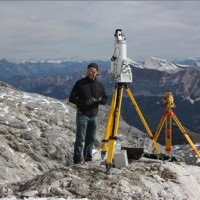
Sentinel-3 Topography mission Assessment through Reference Techniques
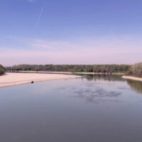 The Copernicus Sentinel-3 Surface Topography Mission (STM) provides extremely valuable surface elevation information over inland waters, sea ice and land ice, thanks to its SAR altimeter which retrieves high-resolution along-track elevation measurements, and to its orbit that covers high-latitude polar regions.
To ensure that these measurements can be used with confidence, and to maximize the return on investment of the Copernicus Sentinel-3 ...
The Copernicus Sentinel-3 Surface Topography Mission (STM) provides extremely valuable surface elevation information over inland waters, sea ice and land ice, thanks to its SAR altimeter which retrieves high-resolution along-track elevation measurements, and to its orbit that covers high-latitude polar regions.
To ensure that these measurements can be used with confidence, and to maximize the return on investment of the Copernicus Sentinel-3 ... Where we should not expect landslides?
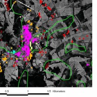
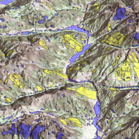 Landslide susceptibility is the propensity of a territory to generate landslides.
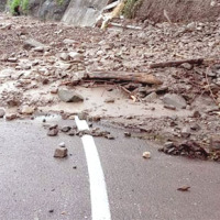
Many methods are available to determine landslide susceptibility, whereas only a few attempts were made to outline areas not likely to generate landslides i.e., non-susceptible landslide areas. This is surprising, because for planning purposes it is just as important (if not more important) to know where landslides are not expected than to know where landslides ...
Landslide susceptibility is the propensity of a territory to generate landslides.
Many methods are available to determine landslide susceptibility, whereas only a few attempts were made to outline areas not likely to generate landslides i.e., non-susceptible landslide areas. This is surprising, because for planning purposes it is just as important (if not more important) to know where landslides are not expected than to know where landslides ... ALMOND-F, an ALarm and MONitoring system for Debris-Flows
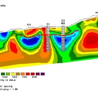
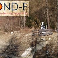 ALMOND-F is an innovative unit for the microseismic detection of debris flows using a network of geophones.
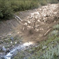
The microseismic detection of debris flows is more complex than other types of monitoring. Use of the geophones requires: (1) the selection of the level of amplification of the signal, which depends on the distance from the stream; (2) the selection of the sampling frequency of the seismic signal, which must be sufficiently high; (3) ...
ALMOND-F is an innovative unit for the microseismic detection of debris flows using a network of geophones.
The microseismic detection of debris flows is more complex than other types of monitoring. Use of the geophones requires: (1) the selection of the level of amplification of the signal, which depends on the distance from the stream; (2) the selection of the sampling frequency of the seismic signal, which must be sufficiently high; (3) ... Progetto ADAPT
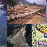
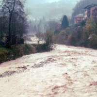
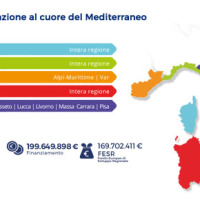 The ADAPT project, co-funded by the Interreg Italy-France Maritime Program 2014-2020, aims to adapt the Italian and French cities of the Upper Tyrrhenian to the consequences of climate change, with particular reference to the urban flash floods caused by intense meteorological ...
 Towards geohazards resilient infrastructure under changing climates
 A trend of increasingly frequent intense rainfalls and changing rainfall patterns is causing a relevant number of landslides and floods affecting urban areas and engineering infrastructures such as roads, railways. Recently Transport networks across Europe experienced several failures the reasons of which are still poorly understood.. To improve the current situation, a step change in the way we design reliable and effective defence structures ...
 Connecting European Connectivity Research
 Water and sediment connectivity has emerged in recent years as a significant conceptual framework for understanding the transfer of surface water and sediment through landscapes. Connectivity can be seen both as a driver of hydrological and geomorphic processes within a catchment and as an emergent catchment property that is the result of processes acting at different ...
 Sediment management in Alpine basins
 The understanding of the changing equilibrium between sediment supply from upstream and sediment transport capability of a river is important for the success of integrated water resource management. In Alpine river basins, intensive sediment transport processes and sediment continuity have a notable impact on several water management issues posing multiple use conflicts related to hydropower, ecology, flood control ...
 Changing Hydro-meteorological Risks as Analyzed by a New Generation of European Scientists
 The European Commission has identified the need for adaptations in risk management as a consequence to climate and environmental changes in several documents. The implementation of risk management measures such as disaster preparedness programmes, land-use planning, regulatory zoning and early warning systems are considered essential. Further, multi-risk assessment approaches are not used in planning practice: risk indicators are hardly used ...
 Glacial hazards in the western Alps
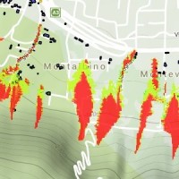
 The project is included in Operative Program of the European cross-border territorial cooperation "Alcotra 2007-2013". It brings together specialized scientific expertise Italian and French that deal to study the mountain and its dangerousness. It is divided into a part of studies conducted on the entire framework of the Western Alps and in actions on the pilot sites identified by the ...
 Long-term Permafrost Monitoring Network
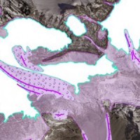
 Permafrost is very sensitive to climate change and the risks associated with its degradation affect traffic routes, settlements and infrastructure. Data on the distribution of permafrost are inconsistent and there is no common strategy to tackle this problem. Local administrators should have the means to manage the risks associated with the degradation of the ...
 Mountain Risks: from prediction to management and governance
 The observed increase in disastrous events over the last decades, associated with a low perception of risk by the communities involved, along with the lack of efficient, socially accepted and environmentally sound remedial measures are amongst the motivation behind this research project. The adaptation of a combined multi-risk-oriented analysis, in which the investigations focus more on the interdependence of events rather than on single event, ...
 Hydrometeorological data resources and technologies for effective flash flood forecasting
 Flash-floods develop at space and time scales that conventional observation systems for rainfall and river discharge are not able to monitor. Consequently, the atmospheric and hydrological generating mechanisms of flash-floods are poorly understood, leading to highly uncertain forecasts of these ...
 Landslide Early Warning Integrated System
 The focus on landslides results from the recognition that in many European countries slope instabilities affect urbanized areas and are a major threat to populations.
Through the integration of remotely sensed data with ground data we identify significant surface changes which are taking place on landslide susceptible slopes and this is used as input to the assessment of ...
The focus on landslides results from the recognition that in many European countries slope instabilities affect urbanized areas and are a major threat to populations.
Through the integration of remotely sensed data with ground data we identify significant surface changes which are taking place on landslide susceptible slopes and this is used as input to the assessment of ... Prevention, Information and Early Warning pre-operational services to support the management of risks
 PREVIEW is an integrated project by the European Commission 6th Framework Programme, led by the EURORISK Consortium, a multi-disciplinary European Team of committing Actors of the domain: Civil Protections and Environmental Bodies; Scientific communities and Service operators, at national and regional level, for Meteorology, Hydrology, Seismology, Volcanology and GIS services based on Space data; and Industry. The project was organized around a ...
 Responding to the risks from climate change
 ‘Response’ (or ‘Responding to the risks from climate change’) is a three-year Project supported by the LIFE financial instrument of the European Community, completed in December 2006. The Project provides a framework for understanding and preparing for the impacts of climate change around the European ...