Geological-geotechnical monitoring systems are one of the most effective tools for landslide characterization, both in terms of landslide detection and for monitoring purposes. The regional monitoring network of Regione Lombardia represents an exemplary case in Italy, with as many as 44 landslides monitored, of which more than half in real time.
The management of monitoring networks and early warning systems represents a complex component, in ...
Landslide susceptibility is the propensity of a territory to generate landslides.
Many methods are available to determine landslide susceptibility, whereas only a few attempts were made to outline areas not likely to generate landslides i.e., non-susceptible landslide areas. This is surprising, because for planning purposes it is just as important (if not more important) to know where landslides are not expected than to know where landslides ...

Despite the large number and frequency of landslides and floods that affect our territories, and the information on landslides and floods available also online, the subject of geo-hydrological hazards remains poorly known to the Italian citizens. The lack of understanding reflects in the limited perception of the population on the geo-hydrological risks in Italy.
One reason for the lack of understanding is the way in which the subject of ...
The research activity aims at defining a coherent and unambiguous framework for the assessment and zonation of seismically induced landslides, at different geographical, temporal and management scales. To this end, the project works at the pre-event temporal scale, concerning spatial planning and soil protection and corresponding to years to decades time periods, and at the real-time or civil protection scale, corresponding to time periods ...
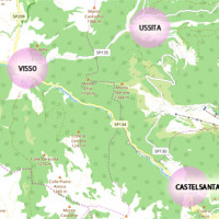
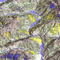
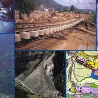
The seismic events that have affected central Italy since 24 August 2016 have caused extensive damage in the municipalities of Castelsantagelo sul Nera, Ussita and Visso (Marche Region). In order to proceed with the reconstruction, it is necessary to carry out interventions to reduce the hydraulic risk in urban ...
The management of emergencies, in particular those determined by natural events, is complex and must be able to use all the available cognitive elements. During emergencies, it is possible to acquire useful data regarding the processes that determine the same emergencies. These data can contribute to significantly improve planning and design of prevention ...
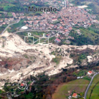
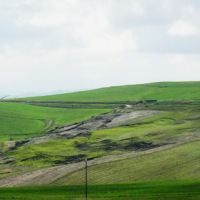
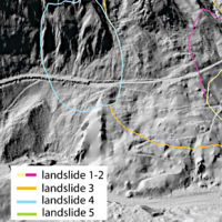
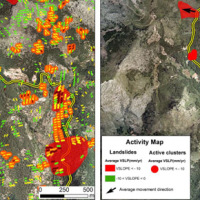
The Maierato landslide (Vibo Valentia Province) is a complex movement, which involved a significant thickness of geomaterials (rocks and soils) and rapidly flowed away for one kilometre. Owing that, the surrounding zone is interested by the same geological settings that predisposed the Maierato landslide, it is useful to identify any elements indicative of the presence of instabilities that can be triggered and evolved as the Maierato ...
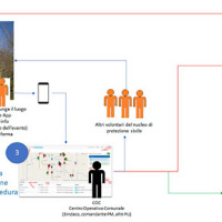
The knowledge of the geo-hydrological hazard of a territory and of the risk conditions for people, are essential for the implementation of civil protection activities. The monitoring activity by personnel, voluntary or not, is a strategic resource for all phases of civil ...
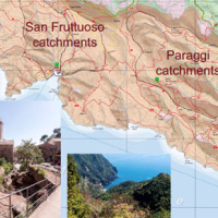
RECONECT is a Horizon 2020 project that aims to enhance the European reference framework on Nature Based Solutions (NBS) for hydro-meteorological risk reduction by demonstrating, referencing, upscaling and exploiting large-scale NBS in rural and natural areas. The Pilot site is the Portofino Natural Regional Park (Ligurian Apennines), 25 km E of Genoa. The park extends along both sides of the Promontory of Portofino, facing Tigullio and ...
A trend of increasingly frequent intense rainfalls and changing rainfall patterns is causing a relevant number of landslides and floods affecting urban areas and engineering infrastructures such as roads, railways. Recently Transport networks across Europe experienced several failures the reasons of which are still poorly understood.. To improve the current situation, a step change in the way we design reliable and effective defence structures ...
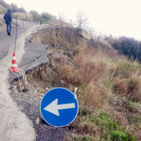
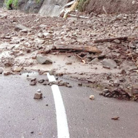
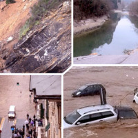
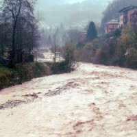
During about two months, two rain events that occurred in the periods 25-26 November 2016 and 22-25 January 2017 affected Calabria region, producing landslides and floods and causing huge damage on large ...
Il progetto prevede un’attività di servizio e di supporto tecnico scientifico per la realizzazione di progetti standard che affrontano i temi della pianificazione comunale di protezione civile e degli strumenti che possono rendere maggiore la sua efficacia. Il progetto propone uno schema che consente di definire, con metodologia rigorosa e omogenea, le attività da svolgere e il modo in cui svolgerle, per la realizzazione di un modello di ...
The Apulia region is affected by multiple types of geo-hydrological instability processes such as sinkholes, flash floods and landslides.
Landsliding mainly affects the north-western sector of the Region (bordering with Apennine chain) and the sea rocky cliffs.
The sub-Appennine Daunia portion of the Region is exposed to landslide risk due to hydro-geological setup of the soil/rock deposits, the poor mechanical properties of the ...
L’area del "Passo della Morte" (UD) è interessata da una situazione di grave dissesto a causa della presenza di più movimenti franosi. Questi sono caratterizzati da elevata pericolosità in relazione alle caratteristiche intrinseche dei fenomeni (volumetrie e velocità di spostamento), alla morfologia del versante ed alla geologia dell'area. La loro presenza mette a rischio la rete stradale che collega la Carnia con il Cadore e l’asta ...

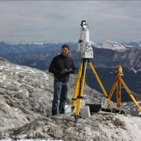
The 3DA software is a new procedure that allows retrieving in near-real-time 3D surface deformation models starting from data acquired via robotized total stations or others system that acquire the surface displacements. The measurements are first pre-processed and then implemented on 3D maps that include vector arrows representative of the intensities and of the real directions of motion in a given system of coordinates. The 3D surface ...
SAFETY aims at providing Civil Protection Authorities with the capability of periodically evaluating and assessing the potential impact of geohazards (volcanic activity, landslides and subsidence) on urban areas. The project improves the effort to detect and map geohazards, assess their activity and evaluate their impact on built-up areas and infrastructures ...
In Italy landslides and floods are frequent, widespread and dangerous phenomena, that cause fatalities and serious economic damage. In our country, landslides and floods pose major problems of scientific interest and of social and economic relevance.
The Institute is a Competence Centre for the Italian national Civil Protection Department, an Office of the Prime Minister. For the Department of Civil Protection we execute research and ...
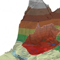
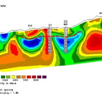
The understanding of the changing equilibrium between sediment supply from upstream and sediment transport capability of a river is important for the success of integrated water resource management. In Alpine river basins, intensive sediment transport processes and sediment continuity have a notable impact on several water management issues posing multiple use conflicts related to hydropower, ecology, flood control ...
The entrance of the tunnel "San Lorenzo" in Forni di Sotto (UD) has built over a an active landslide body. The gravitational deformations of the slope are damaging the lining of the tunnel and creating a hazardous ...
Permafrost is very sensitive to climate change and the risks associated with its degradation affect traffic routes, settlements and infrastructure. Data on the distribution of permafrost are inconsistent and there is no common strategy to tackle this problem. Local administrators should have the means to manage the risks associated with the degradation of the ...
The observed increase in disastrous events over the last decades, associated with a low perception of risk by the communities involved, along with the lack of efficient, socially accepted and environmentally sound remedial measures are amongst the motivation behind this research project. The adaptation of a combined multi-risk-oriented analysis, in which the investigations focus more on the interdependence of events rather than on single event, ...
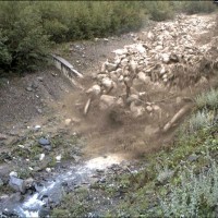
Flash-floods develop at space and time scales that conventional observation systems for rainfall and river discharge are not able to monitor. Consequently, the atmospheric and hydrological generating mechanisms of flash-floods are poorly understood, leading to highly uncertain forecasts of these ...
PREVIEW is an integrated project by the European Commission 6th Framework Programme, led by the EURORISK Consortium, a multi-disciplinary European Team of committing Actors of the domain: Civil Protections and Environmental Bodies; Scientific communities and Service operators, at national and regional level, for Meteorology, Hydrology, Seismology, Volcanology and GIS services based on Space data; and Industry. The project was organized around a ...
