
The 3DA software is a new procedure that allows retrieving in near-real-time 3D surface deformation models starting from data acquired via robotized total stations or others system that acquire the surface displacements. The measurements are first pre-processed and then implemented on 3D maps that include vector arrows representative of the intensities and of the real directions of motion in a given system of coordinates. The 3D surface ...
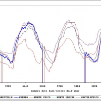
The activities of the project concerns the analysis and processing of hydro-meteorological data collected by the monitoring network of the Umbria Region for the period 1994-2014. In particular, the study regards the rainfall, temperature and water level time series. In addition, the discharge series corresponding to observed water levels are estimated for at hydrometric station through the rating curve estimated on the basis of flow velocity ...
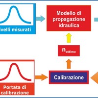
River discharge monitoring is fundamental for the study of the hydraulic regime of river flow and for the validation and calibration of rainfall-runoff models. The assessment of channel roughness coefficients associated with the measured discharges is fundamental for the calibration of flood routing models that can be used to address civil protection activities in real time. Unfortunately, the number of river flow monitoring stations in the ...
The main activities of the project, developed in the context of the program Nextdata funded by the Italian Ministry of Education, University and Research (MIUR), are:
collection, organization and analysis of the available hydro-meteorological and climate data for the characterization of the meteo-climate evolution in Apennine mountain areas;
extensive experimental campaigns for soil moisture monitoring in hillslope portions and ...
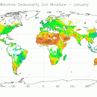
The CCI Programme wants to contribute to the data bases collecting ECVs required by GCOS (Global Climate Observing System) and other international parties. In particular, the Soil Moisture CCI will analyse the needs of the climate research community in terms of soil moisture data, adapt soil moisture satellite measurements for their use by the climate research community and create a long-term consistent soil moisture time series, based on ...
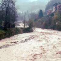
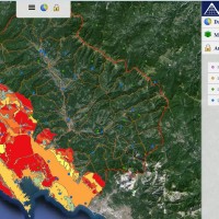
Flash-floods develop at space and time scales that conventional observation systems for rainfall and river discharge are not able to monitor. Consequently, the atmospheric and hydrological generating mechanisms of flash-floods are poorly understood, leading to highly uncertain forecasts of these ...
