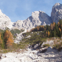
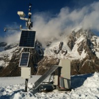
The dataset includes precipitation, temperature and discharge data recorded in the Missiaga catchment (Dolomites). The Missiaga catchment was monitored by CNR IRPI from 1983 to ...
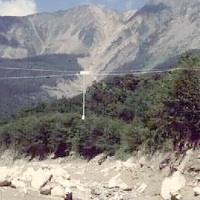
This dataset consists of rainfall data and debris-flow hydrographs recorded in the Moscardo Torrent (Carnic Alps, northeastern Italy).
The Moscardo Torrent was instrumented for debris-flow monitoring by CNR IRPI (Torino office) in 1989; the research was then continued in collaboration with the Padova office. Since 2010 the monitoring activities are carried on in collaboration with the University of Udine (Dept. of Agricultural and ...

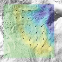
The 3DA software is a new procedure that allows retrieving in near-real-time 3D surface deformation models starting from data acquired via robotized total stations or others system that acquire the surface displacements. The measurements are first pre-processed and then implemented on 3D maps that include vector arrows representative of the intensities and of the real directions of motion in a given system of coordinates. The 3D surface ...
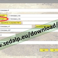
SedInConnect is a stand-alone application for the computation of the Sediment Connectivity Index (Cavalli et al., 2013, Crema et al., 2015).
The software has been developed in the frame of the SedAlp project, funded by the Alpine Space Programme (European Territorial Cooperation 2007-2013)
The output of the applied model is a topography-based index aiming at evaluating the potential connection between hillslopes and features acting as targets ...
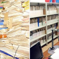
ARCO is the historical archive concerning the geo-hydrological events that occurred in Calabria (south Italy) between 1850 and 1990. The archive is made of 506 folders. 45 folders contain projects of land reclamation, management works of fluvial basins and refunding requests carried out after earthquakes. 461 folders, sorted per municipality, contain refunding requests due to geo-hydrological events, communications between citizens and public ...
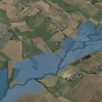
The service is based on a procedure consisting of four main steps: the analysis of hydro-meteorological data for the reconstruction of flood event in terms of precipitations and saturation conditions of the soils; assessment of the hydrological response of the basin; runoff estimation in each hydrometric site of interest; flooded areas delineation and comparison with in-situ ...
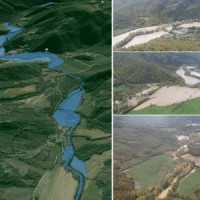
Hydraulic hazard maps for return periods of 50, 100, 200 and 500 ...
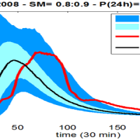
Semi-distributed continuous hydrological model (MISDc) for real-time soil moisture estimate and river discharge prediction in the Upper-Middle Tiber River basin; flood wave routing model (STAFOM-RCM) for stage hydrograph forecasting at some selected hydrometric stations in the Tiber River basin; Rainfall-runoff database coupled with the kinematic model KS for an expeditious estimate of probability flooding ...
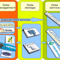
We provide maps and layers through standard OGC services and WebGIS applications.
Our aim is to disseminate information on landslides and floods hazards and the related risk.
More specifically the services focus on thematic data concerning landslides and floods, including: (i) landslide inventory maps at different scales and covering different geographical areas, (ii) landslide susceptibility, hazard and risk maps, and (iii) information on ...
Following the recent technological development, the role of landslides monitoring has become increasingly important, especially for the study and management of large landslides in emergency scenarios. In the last decades, CNR IRPI developed a range of skills dedicated to the design, installation and management of monitoring systems that can be considered for a technical and scientific support in many national emergencies. CNR IRPI can apply ...
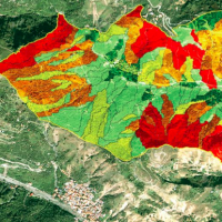
A landslide susceptibility map forecasts where landslides are expected to occur in the future based on terrain conditions, including local morphological, geological, and land use settings. Using different colors, a landslide susceptibility map shows forecasted levels of landslide susceptibility in a region. Using specific software, LSMMs can be prepared whene new landslides or new environmental (e.g., morphological, geological, land use) data ...
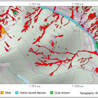
An Event Landslide Inventory Map (ELIM) shows the location and extent of landslides caused by a specific natural trigger, such as an intense rainfall event, a period of prolonged rainfall, a rapid snowmelt event, or an earthquake. The methods and tools developed by CNR-IRPI allow preparation of an ELIM anywhere recent landslides have left discernible ...
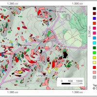
A Landslide Inventory Map (LIM) shows the location, spatial extent and type of landslides in a ...
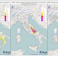
SANF is a landslide early warning system based on the comparison between rainfall measurements and forecasts and empirical rainfall thresholds. Specifically, the system consists of three components: (i) for rainfall and other data input and storage, (ii) for data processing and analysis, and (iii) for the production and delivery of the ...
Based on the application of numerical modelling techniques, CNR – IRPI can provide consulting services on stability/instability conditions and kinematical evolution of potentially unstable slopes, underground caves, embankments, open-pit mines, landfills and any other type of natural or man-made soil/rock structure at ...
